ألاسكا
ألاسكا
| |
|---|---|
| ولاية ألاسكا | |
| الكنية: The Last Frontier | |
| الشعار: North to the Future | |
| النشيد: Alaska's Flag | |
.svg&filetimestamp=20210310123608&) خريطة الولايات المتحدة، موضح فيها ألاسكا | |
| البلد | الولايات المتحدة |
| قبل الولائية | Territory of Alaska |
| انضمت للاتحاد | January 3, 1959 (49th) |
| العاصمة | Juneau |
| أكبر مدينة | Anchorage |
| أكبر منطقة عمرانية | Anchorage metropolitan area |
| Government | |
| • الحاكم | Mike Dunleavy (R) |
| • نائب الحاكم | Kevin Meyer (R) |
| المجلس التشريعي | Alaska Legislature |
| • المجلس العلوي | Senate |
| • المجلس السفلى | House of Representatives |
| القضاء | Alaska Supreme Court |
| سناتورات الولايات المتحدة |
|
| وفد مجلس النواب | Don Young (R) (at-large) (القائمة) |
| Area | |
• Total | 663٬268 ميل² (1٬717٬856 كم²) |
| • Land | 571٬951 ميل² (1٬481٬346 كم²) |
| • Water | 91٬316 ميل² (236٬507 كم²) 13.77% |
| • Rank | 1st |
| Dimensions | |
| • Length | 1٬420 mi (2٬285 km) |
| • Width | 2٬261 mi (3٬639 km) |
| Elevation | 1٬900 ft (580 m) |
| Highest elevation | 20٬310 ft (6٬190٫5 m) |
| Lowest elevation | 0 ft (0 m) |
| Population | |
• Total | 710٬249 |
| • Rank | 48th |
| • Density | 1٫26/sq mi (0٫49/km2) |
| • Rank | 50th |
| • الدخل الأوسط للأسرة | $73٬181[2] |
| • ترتيب الدخل | 8th |
| Demonyms | Alaskan |
| اللغة | |
| • اللغة الرسميةs | Ahtna, Alutiiq, Dena'ina, Deg Xinag, English, Eyak, Gwich'in, Haida, Hän, Holikachuk, Inupiaq, Koyukon, Lower Tanana, St. Lawrence Island Yupik, Tanacross, Tlingit, Tsimshian, Unangax̂, Upper Kuskokwim, Upper Tanana, Yup'ik |
| • اللغة المحكية |
|
| Time zones | |
| east of 169°30' | UTC−09:00 (Alaska) |
| • Summer (DST) | UTC−08:00 (ADT) |
| west of 169°30' | UTC−10:00 (Hawaii-Aleutian) |
| • Summer (DST) | UTC−09:00 (HADT) |
| اختصار البريد | AK |
| ISO 3166 code | US-AK |
| خط العرض | 51°20'N to 71°50'N |
| خط الطول | 130°W to 172°E |
| Website | alaska |
| رموز ولاية Alaska | |
|---|---|
 The علم Alaska | |
 The ختم Alaska | |
| الشارات الحية | |
| الطائر | Willow ptarmigan |
| سلالة الكلاب | Alaskan Malamute |
| السمكة | King salmon |
| الزهرة | Forget-me-not |
| الحشرة | Four-spot skimmer dragonfly |
| الثديي |
|
| الشجرة | Sitka Spruce |
| الشارات الجامدة | |
| الأحفورة | Woolly Mammoth |
| الحجر الكريم | Jade |
| المعدن | Gold |
| غيرهم | Dog mushing (state sport) |
| State route marker | |
 | |
| State quarter | |
 Released in 2008 | |
| قوائم رموز الولايات الأمريكية | |

ألاسكا (إنگليزية: Alaska؛ /əˈlæskə/ (![]() استمع)؛ ألوت: Alax̂sxax̂؛ إنوپياق: Alaasikaq؛ Alutiiq: Alas'kaaq؛ يوپيك: Alaskaq؛[3] تلنگيت: Anáaski)، هي ولاية أمريكية تقع في أقصى الشمال الغربي لـالساحل الغربي. شبه مفصولة عن الولايات المتحدة، تحد مقاطعات كندية كولومبيا الكندية ومنطقة يوكون من الشرق ولها حدود بحرية مع أوكورگ تشوكوتكا الذاتية التابعة لروسيا في الغرب مقابل مضيق بيرنگ. وفي الشمال، بحرا تشوكتشي وبوفورت والمحيط الأطلسي، بينما يقع المحيط الهادي في الجنوب والجنوب الغربي.
تعد ألاسكا أكبر ولاية في الولايات المتحدة من حيث المساحة، حيث أن مساحتها الكلية أكبر من الولايات الثلاث الأكبر التالية وهي تكساس وكاليفورنيا ومونتانا مجتمعات، و سابع أكبر قسم تابع لدولة في العالم. إنها ثالث أقل ولاية مأهولة و الأقل كثافة سكانية، ولكنها أكثر منطقة مأهولة تقع شمال خط عرض 60، بتعداد سكاني يقدر ب 738432 منذ 2015، أكثر من أربعة أضعاف التعداد السكاني لشمال كندا و گرينلاند.[4] يعيش زهاء نصف سكان ألاسكا ضمن منطقة أنكوراج الحضرية. عاصمة الولاية جونو هي ثاني أكبر مدينة في الولايات المتحدة، تضم منطقة أوسع من ولاتي رود أيلاند وديلاوير. العاصمة السابقة لألاسكا ستكا هي أكبر مدينة في الولايات المتحدة من حيث المساحة.
استمع)؛ ألوت: Alax̂sxax̂؛ إنوپياق: Alaasikaq؛ Alutiiq: Alas'kaaq؛ يوپيك: Alaskaq؛[3] تلنگيت: Anáaski)، هي ولاية أمريكية تقع في أقصى الشمال الغربي لـالساحل الغربي. شبه مفصولة عن الولايات المتحدة، تحد مقاطعات كندية كولومبيا الكندية ومنطقة يوكون من الشرق ولها حدود بحرية مع أوكورگ تشوكوتكا الذاتية التابعة لروسيا في الغرب مقابل مضيق بيرنگ. وفي الشمال، بحرا تشوكتشي وبوفورت والمحيط الأطلسي، بينما يقع المحيط الهادي في الجنوب والجنوب الغربي.
تعد ألاسكا أكبر ولاية في الولايات المتحدة من حيث المساحة، حيث أن مساحتها الكلية أكبر من الولايات الثلاث الأكبر التالية وهي تكساس وكاليفورنيا ومونتانا مجتمعات، و سابع أكبر قسم تابع لدولة في العالم. إنها ثالث أقل ولاية مأهولة و الأقل كثافة سكانية، ولكنها أكثر منطقة مأهولة تقع شمال خط عرض 60، بتعداد سكاني يقدر ب 738432 منذ 2015، أكثر من أربعة أضعاف التعداد السكاني لشمال كندا و گرينلاند.[4] يعيش زهاء نصف سكان ألاسكا ضمن منطقة أنكوراج الحضرية. عاصمة الولاية جونو هي ثاني أكبر مدينة في الولايات المتحدة، تضم منطقة أوسع من ولاتي رود أيلاند وديلاوير. العاصمة السابقة لألاسكا ستكا هي أكبر مدينة في الولايات المتحدة من حيث المساحة.
احتلت ألاسكا من قبل شعوب محلية متعددة لآلاف السنين قبل وصول الأوروپيين. تعتبر الولاية أول نقطة دخول للاستيطان في أمريكا الشمالية عبر جسر بيرنگ البري. كان الروس أول من استوطن في المنطقة في بدايات القرن الثامن عشر وأسسوا أمريكا الروسية في نهاية المطاف، والتي تشكل معظم مساحة الولاية حالياً. أدت تكاليف وصعوبة حماية تلك الملكية البعيدة إلى بيعها للولايات المتحدة في 1867 مقابل 7.2مليون دولار أمريكي، أي قرابة سنتين لكل آكر (4.74 دولار للكيلومتر المربع). مرت المنطقة بعدة تغييرات إدارية قبل أن تنظم كـ منطقة في 11 مايو 1912. أدرجت كالولاية التاسعة والأربعين في الولايات المتحدة في 3 يتاير عام 1959.[5]
رغم أنها تمتلك أحد أصغر النظم لااقتصادية في البلاد، إلا أن ألاسكا نصيب الفرد من الدخل من أعلى النسب، يعود ذلك إلى الاقتصاد المتنوع الذي يسوده صيد الأسماك، الغاز الطبيعي و النفط، فكل ما كر موجود بوفرة. تعد قواعد القوى المسلحة الأمريكية و السياحة جزءاً هاماً جداً من الاقتصاد، أكثر من نصف مساحة الولاية أرض عامة مملوكة اتحادياً، من ضمن ذلك معظم الغابات المحلية، المنتزهات، ومأوى الحياة البرية.
عدد السكان الأصليين في ألاسكا يفوق باقي الولايات، بنسبة تزيد عن 15%. [6] هناك قرابة 24 لغة أصلية محكية ويمارس سكان ألاسكا الأصليون أثراً هاماً في السياسة المحلية والدولية.
التسمية
قدم اسم "ألاسكا" (روسية: Аля́ска, النطق Alyáska) في الفترة الستعمارية الروسية حين استخدم للدلالة على شببه جزيرة ألاسكا. اشتق منمصطلحفي لغة الإلويت، والذي يدل مجازياً على البر، ويعني حرفياً المكان الذي تتجه إليه حركة البحر.[7][8][9]
التاريخ
قبل الاستعمار

احتلت العديد من الشعوب المحلية ألاسكا لآلاف الأعوام قبل وصول الأوروپيين إلى المنطقة. تظهر الدراسات اللغوية وأبحاث الحمض النووي أدلة حول استيطان أمريكا الشمالية عبر جسر بيرنگ البري.[10] وجدت بقايا جثة رضيعة تبلغ من العمر ستة أسابيع عند موقع نهر أپوارد سن في وادي نهر تانانا في ألاسكا.يثبت الحمض النووي للرضيعة أنها تنتمي إلى سكان مختلفين جينياً عن باقي المجموعات الأصلية الموجودة في مكان آخر في العالم الجديد في نهاية العصر الجليدي. بين پوتر، عالم آثار في جامعة فربانكس في ألاسكا، اكتشف بقايا الجثة في نهر أپوارد سن في 2013 وسمى هذه المجموعة الجديدة البرينگيين القدماء. [11] طور شعب تيلنجت مجتمعاً يسوده نظام قرابة أمومي فيما يخص ميراث الملكية والنسب في المنطقة التي تتمثل اليوم في جنوب شرق ألاسكا بالإضافة إلى أجزاء من كولومبيا البريطانية و يوكون. كما كان هايدا الشهير بتفرد فنونه، في الجنوب الشرقي. أتى شعب تسمشيان إلى ألاسكا من كولومبيا البريطانية عام 1887، حين أذن لهم الرئيس گروڤر كليڤلاند ولاحقاً مجلس الشيوخ الأمريكي باستيطان جزيرة آنيت وأسسوا مدينة متلاكاتلا. عانى أولئك الشعوب الثلاثة بالإضافة إلى غيرهم من الشعوب الأصلية في الساحل الشمالي الغربي للمحيط الهادي انتشار مرض الجدري منذ أواخر القرن الثامن عشر وحتى منتصف القرن التاسع عشر، مع ظهور أوبئة مؤلمة في 1830 و1860، ما أدى إلى ارتفاع نسبة الوفيات وتفكك في المجتمع.
ما زالت جزر الإلويت موطن مجتمع شعب الإلويت البحري، بالرغم من أنه كان أول الشعوب الصلية تعرضاً للاستغلال على يد الروس. غرب وجنوب غرب ألاسكا موطن يوپ 'إك، بينما يعيش أنسباؤهم ألوتيك~ساگپياك في الجنوب الأوسط من ألاسكا اليوم. شعب گويتش'إن من المنطقة الشمالية الداخلية هو من أثاباسكان يعرفون اليوم باعتمادهم على الوعل ضمن مأوى الحياة البرية المحلية الأطلسية المتنازع عليه. يقطن شعب إنوپيات واسع الانتشار المنحدرات الشمالية و جزيرة ديومد الصغرى.

الاستعمار


وفقاً لبعض الأبحاث، فإن أول استيطان روسي في ألاسكا حدث في القرن السابع عشر.[12] وباء على تلك النظرية، في 1648، وصلت عدة كوتش تابعة لبعثة سميون دزنيوڤ إلى سواحل ألاسكا بسبب عاصفة وأسست المستوطنة. هذه النظرية مبنية على شهادة عالم الجغرافيا بـتشوكتشي نكولاي دوركين، الذي زار ألاسكا في 1764-1765 أبلغ عن قرية عند نهر خوڤرين يقطنها "ملتحون" "يصلون لـأيقونات". يربط بعض الباحثون الحديثون خوڤرين بـنهر كويوك.[13]
يعتقد أن أول سفينة أوروبية وصلت إلى ألاسكا هي سانت گابرييل تحت سلطة المستكشف م. س. گڤوزدڤ ومساعده في الإبحار إ. فيودروڤ في 21 أغسطس 1732، أثناء بعثة الخيال السيبيري أ. ف. شستاكوڤ والمستكشف الروسي دمتري پاڤلوتسكي (1729-1735).[14] ظهر تواصل أوروپي آخر مع ألاسكا في 1741 حين قاد ڤيتوس بيرنگ بعثة للبحرية الروسية على متن سفينة سانت پيتر. بعد عودة طاقمه إلى روسيا حاملاً فراء ثعلب النهر الذي اعتبر أفخر فرو في العالم، بدأت جمعيات صغيرة من تجار الفراء بالإبحار من شواطئ سيبيريا نحو الجزر الإلوتية. أسست أول مستوطنة أوروپية دائمة عام 1784.
بين 1774 و 1800، إسپانيا عدة بعثات إلى ألاسكا لتؤكد مطابها في شمال غرب المحيط الهادي. في 1789، بنيت مستوطنة إسپانية و حصن في نوتكا ساوند. أطلقت تلك البعثات أسماءً على المناطق مثل ڤالديز، بوكارلي، و كردوڤا. لاحقاً، تابعت الشركة الروسية الأمريكية ووسعت البرنامج الاستعماري أثناء بداية وحتى منتصف القرن التاسع عشر. تغير اسم ستكا إلى نيو أركينگل من 1804 وحتى 1867، في جزيرة بارانوف في الكسندر أركيپلاگو فيما يعرف اليوم بـجنوب شرق ألاسكا، أصبحت عاصمة أمريكا الروسية. وبقيت العاصمة بعد أن انتقل الاستعمار إلى الولايات المتحدة. لم يستعمر الروس ألاسكا كلياً، ولم تكن المستعمرة ذات نفع كبير. بقيت الدلائل على الاستعمار الروسي من خلال الأسماء والكنائس في جنوب شرق ألاسكا. فاوض وليام ه سيواردوزير الخارجية في الولايات المتحدة أمر صفقة ألاسكا (تعرف كذلك بسيوارد فولي)، الروس في 1867 مقابل 7.2 مليون دولار. خطط للصفقة أيضاً حاكم روسيا المعاصر تسار الكسندر الثاني، إمبراطور الإمبراطورية الروسية، ملك پولندة و دوق فنلندة الأكبر،[15] تمت الصفقة في 30 مارس عام 1867. بعد ستة أشهر، وصل المفوضون إلى ستكا وتم ترتيب الانتقال الرسمي، رفع العلم رسمياً في حصن ستكا في 18 أكتوبر 1867. في المراسم، سار 250 جندياً بزيهم الرسمي إلى منزل الحاكم في "كاسل هل"، حيث أنزلت الفرق الروسية علمها ورفع علم الولايات المتحدة. يحتفل بهذا الحدث على أنه عيد ألاسكا، وهي عطلة رسمية في 18 أكتوبر. كانت ألاسكا محكومة من الجيش في البداية، وأديرت على أنها ناحية منذ 1884، بوجود حاكم عينه رئيس الولايات المتحدة. وضع المقر الرئيسي لـمحكمة ناحية فدرالية في ستكا. في العقود الأولى من حكم الولايات المتحدة لألاسكا، كانت سيتكا المكان الوحيد الذي يسكنه مستوطنون أمريكيون. نظموا "حكومة مدينة مؤقتة" والتي كانت أول حكومة محلية ولكن ليس بالمعنى القانوني [16]لم يظهر التشريع الذي يسمح لاعتبار مجتمعات ألاسكا أن تشارك قانونياً كمدن حتى 1990، وكان الحكم الذاتي للمدن محدوداً جداً أو غير متوفر حتى سرى مفعول اعتبارها ولاية عام 1959.
ألاسكا كأراضي أمريكية مدمجة
منذ 1890 وحتى بدايات 1910، تم التوسع إلى بعض المناطق، استقطب التنقيب عن الذهب في ألاسكا و منطقة يوكون القريبة آلاف عمال المناجم والمستوطنين. اعتبرت ألاسكا منطقة منظمة رسمياً عام 1912. انتقلت عاصمة ألاسكا والتي كانت ستكا حتى 1906، إلى الشمال في جونو. بدأ بناء قصر حاكم ألاسكا في العام نفسه. استقر المهاجرون الأورپيون من النروج والسويد في جنوب شرق ألاسكا حيث بدأوا بمهنة صيد السمك والتحطيب.

أثناء الحرب العالمية الأولى، ركزت حملة الجزر الإلوتية على أتو، أگاتو، وكسكا، والتي كانت محتلة من قبل إمبراطورية اليابان. [17] أثناء الاحتلال الياباني، قُتل مواطن أمريكي أبيض وموظفان من الهيئة البحرية للولايات المتحدة في أتو وكسكا تباعاً، واحتجز تقريباً 50 من المواطنين الإلوتيين وثمانية بحارين في اليابان. توفي قرابة نصف الإلوتيين أثناء فترة الاعتقال.[18] أصبح كل من أونالاسكا/الميناء الهولندي و أداك قواعداً هامة في جيش الولايات المتحدة، القوى الجوية للولايات المتحدة والهيئة البحرية للولايات المتحدة. تضمن برنامج الإعارة والاسئجار التابع للولايات المتحدة طيران الطائرات الحربية الأمريكية فوق كندا وفيربانكس ثم نوم، استحوذ طيارون سوڤيتيون على الطائرات التي تنقلهم كي يقاتلوا الغزو الألماني للاتحاد السوڤيتي. ساهم بناء القواعد العسكرية في النمو السكاني في بعض مدن ألاسكا.
ولاية ألاسكا
كان ضم ألاسكا كولاية قضية هامة لـجيمس وكرشام في بدايات تبوئه منصب مندوب الكونگرس. بعد عقود، اكتسبت حركة الولاية أول أثر حقيقي لها بعد الاستفتاء الإقليمي عام 1946. تبع ذلك بفترة قصيرة لجنة ولاية ألاسكا و الجمعية الدستورية في ألاسكا.وجد داعمو الولاية أنفسهم يقاتلون معارك هامة ضد خصومهم السياسيين، غالباً في كونگرس الولايات المتحدة وضمن ألاسكا. وافق الكونگرس على اعتبارها ولاية في 7 يوليو 1958. أعلنت ألاسكا كولاية بشكل رسمي في 3 يناير 1959.
في 1960، قال المكتب الإحصائي أن نسبة البيض في ألاسكا 72%، والسود 3% والهنود الأمريكيين وسكان ألاسكا الأصليين 18.8%.[19]

زلزال الجمعة الطيبة
في 27 مارس 1947، أودى زلزال الجمعة الطيبة بحياة 133 شخصاً ودمر عدة بلدات وأجزاءً من مجتمعات ساحلية، ناجمة بشكل أساسي عن تسونامي والانزلاقات الأرضية. كان ثاني أقوى زلزال في التاريخ المسجل، مع درجة العزم 9.2 (أقوى بألف مرة من زلزال سان فرانسيسكو 1989).[20] اعتبر أن الوقت (5:36 مساءً)، والفصل (الربيع) وموقع مركز الزلزال كانت عواملاً في نجاة آلاف الناس وتحديداً في أنكوراج. [ممن؟]
النفط
قاد اكتشاف النفط عام 1968 في خليج پرودو وإكمال نظام الأنانبيب الناقلة في ألاسكا عام 1977، إلى ثورة في النفط. مولت العائدات الملكية من النفط ميزانيات كبيرة للولاية منذ 1980 وبعدها. وفي نفس العام، وليس مصادفةً، ألغت ألاسكا ضريبة الولاية.
في 1989، اصطدمت إكسون ڤالديز بشعاب مرجانية، سكبت 1100 لتر من النفط على مسافة 1800 ميل من الشريط الساحلي. يبدو اليوم أن الجدال ما بين فلسفتي الحفاظ أو تطويرالتنقيب عن النفط مستمر في مأوى الحياة البرية في الأطلسي و منجك پيبل.
مسح موارد التراث
مسح موارد ألاسكا التراثية هو جرد محدود لكل المواقع التاريخية وماقبل التاريخية ضمن ولاية ألاسكا، يحفظها مكتب التاريخ والآثار. تضمن مسح الموارد الثقافية أدوات وهياكل وأبنية ومواقع ومناطق وطرق سفر شريطة أن يكون عمرها أكثر من 50 عاماً. اعتباراً من 31 يناير 2012، أبلغ عن أكثر من 35 ألف موقع.[21]
المدن والبلدات والأحياء

.jpg&filetimestamp=20230904042124&)


Alaska is not divided into counties, as most of the other U.S. states, but it is divided into boroughs.[22] Delegates to the Alaska Constitutional Convention wanted to avoid the pitfalls of the traditional county system and adopted their own unique model.[23] Many of the more densely populated parts of the state are part of Alaska's 16 boroughs, which function somewhat similarly to counties in other states. However, unlike county-equivalents in the other 49 states, the boroughs do not cover the entire land area of the state. The area not part of any borough is referred to as the Unorganized Borough.
The Unorganized Borough has no government of its own, but the U.S. Census Bureau in cooperation with the state divided the Unorganized Borough into 11 census areas solely for the purposes of statistical analysis and presentation. A recording district is a mechanism for management of the public record in Alaska. The state is divided into 34 recording districts which are centrally administered under a state recorder. All recording districts use the same acceptance criteria, fee schedule, etc., for accepting documents into the public record.
Whereas many U.S. states use a three-tiered system of decentralization—state/county/township—most of Alaska uses only two tiers—state/borough. Owing to the low population density, most of the land is located in the Unorganized Borough. As the name implies, it has no intermediate borough government but is administered directly by the state government. In 2000, 57.71% of Alaska's area has this status, with 13.05% of the population.[24]
Anchorage merged the city government with the Greater Anchorage Area Borough in 1975 to form the Municipality of Anchorage, containing the city proper and the communities of Eagle River, Chugiak, Peters Creek, Girdwood, Bird, and Indian. Fairbanks has a separate borough (the Fairbanks North Star Borough) and municipality (the City of Fairbanks).
The state's most populous city is Anchorage, home to 291,247 people in 2020.[25] The richest location in Alaska by per capita income is Denali ($42,245). Yakutat City, Sitka, Juneau, and Anchorage are the four largest cities in the U.S. by area.
المدن والأماكن المعينة بالإحصاء (حسب التعداد)
As reflected in the 2020 United States census, Alaska has a total of 355 incorporated cities and census-designated places (CDPs).[26] The tally of cities includes four unified municipalities, essentially the equivalent of a consolidated city–county. The majority of these communities are located in the rural expanse of Alaska known as "The Bush" and are unconnected to that contiguous North American road network. The table at the bottom of this section lists about the 100 largest cities and census-designated places in Alaska, in population order.
Of Alaska's 2020 U.S. census population figure of 733,391, 16,655 people, or 2.27% of the population, did not live in an incorporated city or census-designated place.[25] Approximately three-quarters of that figure were people who live in urban and suburban neighborhoods on the outskirts of the city limits of Ketchikan, Kodiak, Palmer and Wasilla. CDPs have not been established for these areas by the United States Census Bureau, except that seven CDPs were established for the Ketchikan-area neighborhoods in the 1980 Census (Clover Pass, Herring Cove, Ketchikan East, Mountain Point, North Tongass Highway, Pennock Island and Saxman East), but have not been used since. The remaining population was scattered throughout Alaska, both within organized boroughs and in the Unorganized Borough, in largely remote areas.
|
|
الجغرافيا
تقع ألاسكا في أقصى الشمال وأقصى الغرب بالنسبة إلى الولايات المتحدة وتملك أطول ساحل شرقي لأن الجزر الإلوتية تمتد إلى النصف الشرقي من الكرة الأرضية. [27] ألاسكا هي الولاية الوحيدة غير المجاورة في قارة أمريكا الشمالية، يفصلها عن واشنطن مسافة 800 كيلومتر من كولومبيا البريطانية (كندا). إنها فعلياً جزء من الولايات المتحدة في أمريكا الشمالية ولكنها غير مشمولة أحياناً في الاستخدام الدارج للكلمة.ليست ألاسكا جزءاً من الولايات المتحدة المتجاورة، تدعى غالباً باسم "ال48 السفلية". تقع العاصمة جونو على البر في قارة أمريكا الشمالية ولكنها غير متصلة طرقياً بباقي نظام الطرق السريعة في أمريكا الشمالية.
يحد الولاية يوكون الكندية وكولومبيا البريطانية من الشرق (ما يجعلها الولاية الوحيدة التي تحد مناطق كندية)، خليج ألاسكا والمحيط الهادي من الجنوب والجنوب الغربي، بحر بيرنگ و مضيق بيرنگ و بحر تشوكتشي من الغرب والمتجمد الشمالي من الشمال. تلتلقي مياه ألاسكا الإقليمية بمياه روسيا الإقليمية عند مضيق بيرنگ حيث أن جزيرة ديومود الكبيرة الروسية تبعد عن جزيرة ديومود الصغيرة ألاسكا 4.8 كيلومتر. تمتلك ألاسكا خطاً ساحلياً أطول من بقية الولايات المتحدة مجتمعة.[28]

بمساحة 1,717,856 كيلومتر مربع، تعتبر ألاسكا أكبر ولاية في الولايات المتحدة، وتبلغ مساحتها أكبر من ضعفي حجم ثاني أكبر ولاية أمريكية وهي تكساس. ألاسكا في المركز السابع من أكبر المناطق التابعة لدولة من حيث المساحة، ولو أنها أمة مستقلة لكان ترتيبها 19 من حيث الحجم، حيث أنها أكبر من إيران.
With its myriad islands, Alaska has nearly 34،000 ميل (55،000 km) of tidal shoreline. The Aleutian Islands chain extends west from the southern tip of the Alaska Peninsula. Many active volcanoes are found in the Aleutians and in coastal regions. Unimak Island, for example, is home to Mount Shishaldin, which is an occasionally smoldering volcano that rises to 10،000 أقدام (3،000 m) above the North Pacific. The chain of volcanoes extends to Mount Spurr, west of Anchorage on the mainland. Geologists have identified Alaska as part of Wrangellia, a large region consisting of multiple states and Canadian provinces in the Pacific Northwest, which is actively undergoing continent building.
One of the world's largest tides occurs in Turnagain Arm, just south of Anchorage, where tidal differences can be more than 35 أقدام (10.7 m).[29]
Alaska has more than three million lakes.[30] Marshlands and wetland permafrost cover 188،320 ميل مربع (487،700 km2) (mostly in northern, western and southwest flatlands). Glacier ice covers about 28،957 ميل مربع (75،000 km2) of Alaska.[31] The Bering Glacier is the largest glacier in North America, covering 2،008 ميل مربع (5،200 km2) alone.[32]
المناطق
لا يوجد حدود موضحة بشكل رسمي تفصل مناطق ألاسكا المتعددة، ولكن هناك ست مناطق كبرى:
جنوب الوسط
تضم أكثر منطقة مأهولة في ألاسكا أنكوراج، وادي ماتانوسكا-سوسيتنا و شبه جزيرة كيناي. يشكل الريف مناطق غير مأهولة غالباً جنوب قمم ألاسكا وغرب جبال رنگلويقع أيضاً ضمن جنوب الوسط، مثل منطقة برينس وليام ساوند ومجتمعات كوردوڤا و ڤالديز.[33]
جنوب الشرق
يشار إليها أيضاً بپانهاندل أو المعبر الضيق، إنها أكثر مناطق ألاسكا قرباً من الولايات المتجاورة، حيث أنها المكان التي ظهر فيه أول استيطان غير مجاور في الأعوام التي تلت صفقة ألاسكا. يطغى على المنطقة أرخبيل ألكسندر بالإضافة إلى غابة تونگاس الوطنية، وهي أكبر غابات الولايات المتحدة. تضم العاصمة جونو، والعاصمة السابقة ستكا و كيتشيكان التي كان يوماً ما أكبر مدن ألاسكا.[34] يزود طريق مارين السريع المنطقة بخدمة طقية برية نشطة حيث أنه صلة الوصل بين المنطقة والدولة، فهناك ثلاث مجتمعات فحسب تتمتع باتصال مباشر بنظام الطرق لولايات أمريكا الشمالية المباشرة وهي (هاينسوهايدر وسكاگوي).[35]
المنطقة الداخلية

المنطقة الداخلية هي أكبر مناطق ألاسكا وهي بمعظمها برية غير مأهولة. فيربانكس هي أكبر مدينة في المنطقة. تقع هناك محمية وحديقة دينالي الوطنية. تقع هناك أيضاً دينالي والتي كانت تعرف بجبل مكنيلي وهو أعلى جبل في أمريكا الشمالية.
جنوب الغرب

الكثافة السكانية منخفضة في جنوب غرب ألاسكا وتمتد مساحة 800 كيلومتر إلى الداخل من بحر بيرنگ. يعيش معظم السكان على طول الشريط الساحلي. تقع جزيرة كودياك أيضاً في الجنوب الغربي. يقع هناك دلتا يوكون-كوسكوكويم الهائل هو أحد أكبر دالات الأنهار في العالم. تعتبر بعض أجزاء شبه جزيرة ألاسكا جزءاً من الجنوب الغربي، بينما تعتبر باقي الأجزاء تابعة للجز الإلوتية (انظر في الأسفل).
السهوب الشمالية
المنحدر الشمالي عبارة عن سهول جليدية تتناثر فيه بعض القرى الصغيرة. تشتهر المنطقة بمخزونها الهائل من النفط الخام حيث أنها تضم كلاً من مخزون النفط الوطني-ألاسكا وحقل نفط خليج برودو.[36] مدينة أوتكياڤيك، التي كانت تعرف باسم بارو، وهي المدينة التي تقع في أقصى غرب الولايات المتحدة، موجودة هناك أيضاً. منطقة شمال غرب الأطلسي ومعه كوتزبيو ويضم أيضاً وادي نهر كوبيوك، يعتبر جزءاً من المنطقة. رغم ذلك، نادراً ما يعتبر أنوبيات القاطنين في المنحدر الشمالي وفي شمال غرب المتجمد الشمالي أنفسهم شعباً واحداً.[37]
جزر ألوشن
.png&filetimestamp=20230822110341&)
While primarily part of Southwest Alaska when grouped economically, the Aleutian islands are sometimes recognized as an alternate group from the rest of the region due to the geographic separation from the continent. تشكل أكثر من 300 جزيرة بركانية صغيرة هذه السلسة والتي تمتد على أكثر من (1900 كيلومتر) في عمق المحيط الهادي. تقع بعض تلك الجزر في نصف الكرة الأرضية الشرقي، ولكن رسم خط التاريخ الدولي غرب 180 درجة وذلك من أجل إبقاء الولاية كلها، وبالتالي كل قارة أمريكا الشمالية، في نفس التاريخ اليومي الرسمي. احتلت اثنتين من تلك الجزر من قبل القوات اليابانية في الحرب العالمة الثانية وهما أتو وكسكا.
الخصائص الطبيعية

يشكل نظام الإقليم الباسفيكي الجبلي لولاية ألاسكا جزءًا من السلاسل الجبلية التي تمتد جنوبًا بمحاذاة ساحل المحيط الهادي حتى جنوبي كاليفورنيا في الولايات المتحدة. وتنعطف السلاسل الجبلية في ألاسكا من جزر ألوُشيَن في الغرب مخترقة جنوب أواسط ألاسكا ثم تتواصل في محاذاة الساحل في الجنوب الشرقي من الولاية.
وينقسم الإقليم الباسفيكي الجبلي إلى أقسام فرعية، ففي الجنوب الشرقي توجد أراضٍ ساحلية طولها 640كم تسمى يد مقلاة ألاسكا.وهي عبارة عن لسان أرض شبيه بيد المقلاة. وتوجد في هذا الإقليم الفرعي جبال عالية وحقول ثلجية. وتمتد من يد مقلاة ألاسكا نحو الشمال الغربي، سلسلة جبال سانت إلياس. ومنها ترتفع في اتجاه الشمال الغربي أيضًا جبال رانجل. وتمتد جبال تشوغاش وكيناي بجانب الساحل من سلسلة جبال سانت إلياس غربًا إلى شبه جزيرة كِينَال وجزيرة كُودياَك.
أما جبال تالكيتنا الواقعة إلى الشمال من أنكورج فهي سلسلة قليلة الارتفاع وعرة تشققت قممها بفعل الأنهار الجليدية. تعتبر سلسلة جبال ألاسكا ـ وهي تضم جبل ماكنلي ـ أبعد أجزاء سلاسل جبال المحيط الهادئ عن الساحل.
تمتد شبه جزيرة ألاسكا وجزر ألوشيان إلى الجنوب الغربي على هيئة سلسلة طويلة. وتبدو جبال الألوشيان هذه كالعمود الفقري لشبه الجزيرة، فهي تمتد بطول يبلغ 2,570 كم، وبها كثير من البراكين النشطة. تضم سلاسل جبال المحيط الهادئ بقعتين مهمتين من الأراضي السهلية المنخفضة. تتكون سلاسل جبال الروكي في ألاسكا من سلسلة جبال بروكس ومنحدراتها. ولجبال بروكس قمم شديدة الانحدار جزَّأتها الأنهار الجليدية. ويقع في أقصى الشمال السهل الساحلي للمحيط القطبي الشمالي. ويقع تحت هذا السهل وبُسْمك يبلغ 300م مايسمى بِرْمَافرُسْت أي الأرض دائمة التجمد. يبلغ طول ساحل ألاسكا بصفة عامة 10,686كم، وهو بذلك أطول من كل سواحل الولايات المتحدة مجتمعة. يحتل نهر يوكون ـ وهو أهم الطرق المائية في ألاسكا ـ المرتبة الخامسة بين أنهار أمريكا الشمالية من حيث الطول. وفي ألاسكا أيضًا آلاف البحيرات، أكبرها بحيرة إليامنا الواقعة في شبه جزيرة ألاسكا. تنتشر في الوديان الواسعة والضيقة في ألاسكا آلاف الأنهار الجليدية، خصوصًا عند السواحل في الجنوب والجنوب الشرقي من الولاية. وكثير من هذه الأنهار يمكن الوصول إليها ودراسة أحوالها في سهولة.
البحيرات
يوجد في ألاسكا أكثر من 3 ملايين بحيرة. [38] تغطي برمافورست الأراضي الجافة والأراضي الرطبة بمساحة 487,700 كيلومترمربع (معظمها في الشمال والغرب والجنوب الغربي من الأراضي المنبسطة). يغطي الجليد مساحة 75،000 كيلومتر مربع من ألاسكا. [39] مجمع بيرنگ الجليد هو الأكبر في أمريكا الشمالية ويغطي 5،200 كيلومتر مربع لوحده. [40]
ملكية الأراضي

حسب تقرير صدر في أكتوبر عام 1988 عن مكتب الولايات المتحدة لإدارة الأراضي، فإن قرابة 65% من أراضي ألاسكا ممتلكة ومدارة من قبل [الحكومة الفيدرالية للولايات المتحدة|حكومة الولايات المتحدة الفيدرالية]] كأراض عامة، من ضمنها جزء من الغابة الوطنية، والمنتزهات الوطنية و مأوى الحياة البرية الوطني.[42] يدير منها مكتب إدارة الأراضي 35 مليون هكتار أي 23.8% .تدير المؤسسة الأمريكية للأسماك والحياة البرية مأوى الحياة البرية الوطني في المتجمد الشمالي. إنه أكبر مأوى للحياة البرية في العالم وتبلغ مساحته 6.5 مليون هكتار.
تمتلك ولاية ألاسكا من باقي مساحة اليابسة 41 مليون هكتار، استحقاقها بموجب قانون ولاية ألاسكا. تترك بعض تلك المساحة عادة للأقاليم المنظمة المذكورة سابقاً، بموجب الأحكام التشريعية المتعلقة بالأقاليم حديثة التشكيل. تخصص أجزاء أصغر من أجل الأفرع الريفية والفرص المتعلقة بتكوين المنازل ولكنها لا تتمتع بشعبية كبيرة بسبب مواقعها النائية عديمة المواصلات. تمتلك جامعة ألاسكا كـجامعة منحة أرض مساحةً كبيرةً وتديرها بشكل مستقل.
هناك 18 مليون هكتار تملكها 12 شركة إقليمية وعشرات الشركات المحلية بموجب قانون تسوية مطالب السكان الأصليين في ألاسكا (ANCSA) عام 1971. غالباً ما تروج الشركة الإقليمية الأصلية ديون المحدودة نفسها على أنها أكبر مالك خاص للأراضي في ألاسكا في الإعلانات وغيرها من وسائل التواصل. ألغيت الأحكام التي تسمح ببيع ملكية أراضي الشركات في السوق المفتوحة قبل أن تصبح سارية المفعول في 1991.عملياً، للشركات حق الملكية (من ضمن ذلك الملكية المبطنة في بعض الحالات، وهي ميزة لا يتمتع بها أفراد ألاسكا) ولكن لا يمكنها بيع الأرض. ولكن مخصصات الأفراد الأصلية قد تباع في السوق المفتوحة.
تملك مصالح خاصة متعددة بقية الأراضي، ويبلغ الإجمالي منها إلى واحد بالمئة من الولاية. ألاسكا، بالهامش الأكبر، هي الولاية ذات النسبة الأقل في ملكية الأراضي الخاصة، هذا إذا استثني من ذلك ملكية الشركات الأصلية.
المناخ


| الموقع | يوليو (°F) | يوليو (°C) | يناير (°F) | يناير (°C) |
|---|---|---|---|---|
| أنكوراج | 65/51 | 18/10 | 22/11 | −5/−11 |
| جونو | 64/50 | 17/11 | 32/23 | 0/−4 |
| كتشيكان | 64/51 | 17/11 | 38/28 | 3/−1 |
| أونالاسكا | 57/46 | 14/8 | 36/28 | 2/−2 |
| فيربانكس | 72/53 | 22/11 | 1/−17 | −17/−27 |
| فرونت يوكون | 73/51 | 23/10 | −11/−27 | −23/−33 |
| نوم | 58/46 | 14/8 | 13/−2 | −10/−19 |
| أوتكياڤيك | 47/34 | 08/1 | −7/−19 | −21/−28 |
الديموغرافيا
| التعداد | Pop. | ملاحظة | %± |
|---|---|---|---|
| 1880 | 33٬426 | — | |
| 1890 | 32٬052 | −4٫1% | |
| 1900 | 63٬592 | 98٫4% | |
| 1910 | 64٬356 | 1٫2% | |
| 1920 | 55٬036 | −14٫5% | |
| 1930 | 59٬278 | 7٫7% | |
| 1940 | 72٬524 | 22٫3% | |
| 1950 | 128٬643 | 77٫4% | |
| 1960 | 226٬167 | 75٫8% | |
| 1970 | 300٬382 | 32٫8% | |
| 1980 | 401٬851 | 33٫8% | |
| 1990 | 550٬043 | 36٫9% | |
| 2000 | 626٬932 | 14�0% | |
| 2010 | 710٬231 | 13٫3% | |
| 2019 (تق.) | 731٬545 | 3�0% | |
| 1930 and 1940 censuses taken in preceding autumn Sources: 1910–2010, US Census Bureau[44] 2018 Estimate[4] | |||
العرقية

| Racial composition | 1970[45] | 1990[45] | 2000[46] | 2010[47] |
|---|---|---|---|---|
| White | 78.8% | 75.5% | 69.3% | 66.7% |
| Native | 16.9% | 15.6% | 15.6% | 14.8% |
| Asian | 0.9% | 3.6% | 4.0% | 5.4% |
| Black | 3.0% | 4.1% | 3.5% | 3.3% |
| Native Hawaiian and other Pacific Islander |
– | – | 0.5% | 1.0% |
| Other race | 0.4% | 1.2% | 1.6% | 1.6% |
| Multiracial | – | – | 5.5% | 7.3% |
اللغات
- Inupiaq
- Siberian Yupik
- Central Alaskan Yup'ik
- Alutiiq
- Unangax
- Dena'ina
- Deg Xinag
- Holikachuk
- Koyukon
- Upper Kuskokwim
- Gwich'in
- Tanana
- Upper Tanana
- Tanacross
- Hän
- Ahtna
- Eyak
- Tlingit
- Haida
- Tsimshian
الديانات


| الانتماء | % من السكان | |
|---|---|---|
| المسيحيون | 62 | |
| پروتستانت | 37 | |
| پروتستانت تبشيريون | 22 | |
| پروتستانت التيار العام | 12 | |
| كنيسة سوداء | 3 | |
| كاثوليك | 16 | |
| مورمون | 5 | |
| شهود يهوى | 0.5 | |
| أرثوذكس شرقيون | 5 | |
| مسيحيون آخرون | 0.5 | |
| غير منتمي | 31 | |
| لا شيء بالتحديد | 20 | |
| لا أدري | 6 | |
| ملحدون | 5 | |
| ديانات غير المسيحية | 6 | |
| يهود | 0.5 | |
| مسلمون | 0.5 | |
| بهائيون | 0.2 | |
| بوذيون | 1 | |
| هندوس | 0.5 | |
| ديانات أخرى غير مسيحية | 4 | |
| لا أدري/رفضوا الاجابة | 1 | |
| الإجمالي | 100 | |
الاقتصاد

- التوظيف العام (2016): 266,072
- عدد المؤسسات التوظيفية: 21,077[49]
كان إجمالي نتاج الولاية 55 مليار في 2018، ال48 في الأمة. كان معدل دخل الفرد في عام 2018، 73،000 دولار، في المركز السابع في البلاد. وفق دراسة عام 2013 لفينكس الدولية للتسويق، نسبة الأثرياء في ألاسكا هي خامس أعلى نسبة في الولايات المتحدة، بنسبة تبلغ 6.75 بالمئة.[50] تسيطر صناعات الغاز والنفط على اقتصاد ألاسكا حيث أن أكثر من 80% من إيرادات الولاية تأتي من استخراج النفط. منتج التصدير الأساسي الآخر في ألاسكا (إلى جانب النفط والغاز) هو ثمار البحر، بشكل أساس السلمون والقد والبلوق والسلطعون.
تمثل الزراعة شقاً بسيطاً من اقتصاد ألاسكا. يستهلك معظم منتوج الزراعة ضمن الولاية ويتضمن الغراس ومشتقات الحليب والخضار والماشية. التصنيع محدود، مع استيراد معظم المواد الغذائية والسلع العامة من أماكن أخرى.
يتم التوظيف بشكل أساسي في الحكومة والصناعة مثل استخراج الموارد الطبيعية والشحن والنقل. تعد القواعد العسكرية مكوناً بالغ الأهمية في فيربانكس نورث ستار وأنكوراج وبلدات جزر كودياك بالإضافة إلى كودياك. تعد المعونات الفدرالية جزءاً هاماً من الاقتصاد كذلك حيث تسمح للولاية أن تبقي نسبة الضرائب منخفضة. تتكون منتجاتها الصناعية من البترول الخام والغاز الطبيعي والفحم والذهب والمعادن الثمينة والزنك وغيره من المناجم ومعالجة ثمار البحر والخشب والتحطيب. يوجد أيضاً قطاع السياحة والخدمات النامي. ساهم السواح بالاقتصاد عبر دعم السكن المحلي.
الطاقة

يوجد في ألاسكا وفرة في مصادر الطاقة بالرغم من أن حقولها النفطية استنزفت بشكل كبير. وجدت حقول النفط والغاز الكبرى في منحدرات ألاسكا الشمالية (ANS) وأحواض كوك إنلت ولكن وفقاً لـإدارة معلومات الطاقة، بحلول فبراير 2014، تراجعت ألاسكا إلى المركز الرابع في البلاد بانتاج النفط الخام بعد تكساس، وداكوتا الشمالية وكاليفورنيا. [51][52] لا يزال خليج برودو في المنحدر الشمالي في ألاسكا ثاني أضخم حقل نفط في الولايات المتحدة حيث ينتج عادةً 400،000 برميل يومياً، بالرغم من أنه في بدايات 2014 كانت شركة باكن فورميشن تنتج أكثر من (64,000 م3/ي) يومياً[53] كان خليج برودو أكبر حقل نفط تقليدي مكتشفاً أمريكا الشمالية ولكنه كان أصغر من حقل أثاباسكا النفطي الرملي الهائل في كندا الذي كان ينتج بحلول 2014 قرابة (140,000 م3/ي) يومياً من النفط التقليدي ومر بمئات الأعوام وهو يمتلك نفس معدل القدرة الإنتاجية.[54]
يستطيع نظام الأنابيب في ألاسكا نقل وضخ 2.1 مليون برميل من النفط الخام يومياً وأكثر من أي أنبوب نقل نفط آخر في الولايات المتحدة. بالإضافة إلى كميات الفحم الضخمة التي عثر عليها في أحواض الفحم القاري وشبه القاري والفحم الحجري في ألاسكا. تقدر هيئة المسح الجيولوجي في الولايات المتحدة أن هناك 85.4 ترليون قدم مكعب من الغاز الطبيغي غير المكتشف والقابل للاستخراج من بلورات الغاز الطبيعي في منحدرات ألاسكا الشمالية.ref>"Gas Hydrates on Alaska's North Slope". Usgs.gov. Archived from the original on June 1, 2010. Retrieved June 2, 2010.</ref> تقدم ألاسكا قدراً كبيراً من الطاقة الكهرومائية في البلاد من أنهارها المتعددة. تقدم مساحة شواطئ ألاسكا الكبيرة قدراً كبيراً من طاقة الرياح والطاقة الحرارية الأرضية كذلك.[55]


يعتمد اقتصاد ألاسكا على وقود الديزل، الذي تتزايد تكاليفه، من أجل التدفئة والنقل والطاقة الكهربائية والإنارة. رغم أن طاقة الرياح والطاقة الكهرومائية وفيرة وغير مستنفذة، اعتبرت الاقتراحات لنظام طاقة يشمل الولاية (مثال: الشبكات الكهربائية منخفضة الكلفة) أنها غير اقتصادية (في زمن التقرير عام 2001) بسبب أسعار الوقود (أقل من 50 ¢ للگالون)، والمسافات الشاسعة وانخفاض الكثافة السكانية.[56] كلفة گالون الغاز في ألاسكا المدنية اليوم أعلى بما بين 30 إلى 50 سنتاً من المعدل الوطني، الأسعار في المناطق الريفية أعلى بصورة ملحوظة لأنها تعتمد على تكاليف النقل وذروة الاستخدام الموسمي والبنية التحتية القريبة لتطوير البترول وغير ذلك من العوامل.
الصندوق الدائم
صندوق ألاسكا الدائم هو موازنة مرخصة دستورياً لإيرادات النفط، أسسها الناخبون عام 1976 لإدارة الفائض من إيرادات النفط في الولاية من أجل مراقبة نظام أنابيب ألاسكا الذي كان حديث الإنشاء حينها. اقترح الصندوق الحاكم كيث ميلر عشية عقد البيع التأجيري لخليج برودو عام 1969، خوفاً من أن تنفق الهيئة التشريعية كل إيرادات البيع (والتي بلغت قيمتها 900 مليون دولار) دفعة واحدة. ثم أيد الفكرة الحاكم جاي هاموند و ممثل ألاسكا في كيناي هيو مالون. وأصبح فرصةً سياسيةً مرغوبة منذ ذلك الحين، يحول الإيرادات التي تودع عادةً في الصندوق العام.
كتب دستور ألاسكا لتثبيط تكريس صندوق الولاية لغايات محددة. أصبح الصندوق الدائم الاستثناء النادر لذلك، وذبك بسبب الحالة السياسية التي يشوبها عدم الثقة خلال زمن إحداثه. انطلاقاً من مبلغه المبدأي وهو 734,000 دولار، نما الصندوق إلى 50 مليار دولار كنتيجة لبرامج استثمار النفط الملكية والكبرى.[57] يستثمر معظم المبلغ، هذا إذا لم يكن كله، خارج ألاسكا. أدى ذلك لدعوات من سياسيي ألاسكا للاستثمار ضمن الولاية إلا أنها لم تلق ترحيباً.
بدءاً من 1982، دفعت أسهم من أرباح الصندوق السنوية إلى سكان ألاسكا المؤهلين، تراوحت بين 1000 دولار عام 1982 (ما يعادل تعويضات ثلاث سنوات، حيث أن توزيع المدفوعات علق في قضية بشأن تحايل في التوزيع)، وحتى 3269 دولار في 2008 (والذي يتضمن "اقتطاع موارد" لمرة واحدة بقيمة 1200 دولار). كل عام، يأخذ مجلس الولاية التشريعي 8% من المكاسب ويعيد 3% منها إلى رأس المال تحسباً للتضخم، توزع ال 5% المتبيقية على سكان ألاسكا المؤهلين. من أجل التأهل للاستفادة من أسهم الصندوق الدائم، يجب على المرء أن يكون قد سكن الولاية مدة لا تقل عن 12 شهراً وحافظ على الإقامة الدائمة الخاضعة للغياب المأذون به. ref>"State of Alaska Permanent Fund Division". Pfd.state.ak.us. Archived from the original on April 20, 2010. Retrieved June 2, 2010.</ref> وألا يكون مجرماً بحكم محكمة أو بتهمة جنائية التي تندرج تحت تصنيفات عدم الأهلية المتنوعة وقد تحول مبلغ الدفعات إلى الحجز المدني.
يعتبر الصندوق الدائم أحد الأمثلة الهامة على سياسة "الدخل الأساسي" في العالم.[58]
تكلفة المعيشة
لطالما كانت كلفة البضائع في ألاسكا أعلى من كلفتها في الولايات ال 48 المتجاورة. يتلقى موظفو الحكومة الفدرالية وتحديداً عمال الخدمات البريدية في الولايات المتحدة (USPS) والعسكريون في الخدمة، مصروف تكاليف معيشة تقدر قيمته عادة ب 25% من المدخول الأصلي، رغم أن تكاليف المعيشة انخفضت، إلا انها لا تزال تتمتع بأعلاها في البلاد.[59]
يعاني ريف ألاسكا من ارتفاع في أسعار الأغذية والسلع الاستهلاكية مقارنة ببقية البلاد وذلك بسبب بنية النقل التحتية المحدودة نسبياً. [59]
الزراعة وصيد الأسماك

بسبب الطقس في الشمال وقصر الفصل الإنتاجي، تظهر الزراعة بنسبة قليلة نسبياً في ألاسكا. تقع معظم المزارع إما في وادي ماتانوسكا، قرابة 64 كيلومتر شمال شرق أنكوراج، أو في شبه جزيرة كيناي التي تقع 97 كيلومتراً جنوب غرب أنكوراج. موسم الإنتاج القصير الذي يبلغ 100 يوم، يسمح بزراعة محاصيل معينة ولكن أيام الصيف المشمسة الطويلة تجعل موسم الإنتاج وفيراً. المحاصيل الأساسية هي البطاطا والجزر والخس والملفوف.
وادي تانانا موقع زراعي هام آخر، وتحديداً منطقة دلتا جنكشن، تقع 160 كيلومتر جنوب شرق فيربانكس، بوجود تجمع كبير من المزارع الي تزرع المحاصيل، تقع معظم تلك المزارع شمال وشرق فورت غريلي. خصصت المنطقة وطورت تحت برنامج يرعاه هاموند خلال فترته الثانية كحاكم. تتكون محاصيل منطقة الدلتا من الشعير والتبن. يقع غرب فيربانكس تجمع آخر للمزارع الصغيرة تخدم المطاعم والفانادق والسياحة و الزراعة المدعومة مجتمعياً.
Alaskan agriculture has experienced a surge in growth of market gardeners, small farms and farmers' markets in recent years, with the highest percentage increase (46%) in the nation in growth in farmers' markets in 2011, compared to 17% nationwide.[60] The peony industry has also taken off, as the growing season allows farmers to harvest during a gap in supply elsewhere in the world, thereby filling a niche in the flower market.[61]


Alaska, with no counties, lacks county fairs. However, a small assortment of state and local fairs (with the Alaska State Fair in Palmer the largest), are held mostly in the late summer. The fairs are mostly located in communities with historic or current agricultural activity, and feature local farmers exhibiting produce in addition to more high-profile commercial activities such as carnival rides, concerts and food. "Alaska Grown" is used as an agricultural slogan.
Alaska has an abundance of seafood, with the primary fisheries in the Bering Sea and the North Pacific. Seafood is one of the few food items that is often cheaper within the state than outside it. Many Alaskans take advantage of salmon seasons to harvest portions of their household diet while fishing for subsistence, as well as sport. This includes fish taken by hook, net or wheel.[62]
Hunting for subsistence, primarily caribou, moose, and Dall sheep is still common in the state, particularly in remote Bush communities. An example of a traditional native food is Akutaq, the Eskimo ice cream, which can consist of reindeer fat, seal oil, dried fish meat and local berries.
Alaska's reindeer herding is concentrated on Seward Peninsula, where wild caribou can be prevented from mingling and migrating with the domesticated reindeer.[63]
Most food in Alaska is transported into the state from "Outside", and shipping costs make food in the cities relatively expensive. In rural areas, subsistence hunting and gathering is an essential activity because imported food is prohibitively expensive. Although most small towns and villages in Alaska lie along the coastline, the cost of importing food to remote villages can be high, because of the terrain and difficult road conditions, which change dramatically, due to varying climate and precipitation changes. The cost of transport can reach as high as 50¢ per pound ($1.10/kg) or more in some remote areas, during the most difficult times, if these locations can be reached at all during such inclement weather and terrain conditions. The cost of delivering a 1 غالون أمريكي (3.8 L) of milk is about $3.50 in many villages where per capita income can be $20,000 or less. Fuel cost per gallon is routinely twenty to thirty cents higher than the contiguous United States average, with only Hawaii having higher prices.[64][65]
النقل

الطرق


Alaska has few road connections compared to the rest of the U.S. The state's road system covers a relatively small area of the state, linking the central population centers and the Alaska Highway, the principal route out of the state through Canada. The state capital, Juneau, is not accessible by road, only a car ferry; this has spurred debate over decades about moving the capital to a city on the road system, or building a road connection from Haines. The western part of Alaska has no road system connecting the communities with the rest of Alaska.

The Interstate Highways in Alaska consists of a total of 1082 miles. One unique feature of the Alaska Highway system is the Anton Anderson Memorial Tunnel, an active Alaska Railroad tunnel recently upgraded to provide a paved roadway link with the isolated community of Whittier on Prince William Sound to the Seward Highway about 50 ميل (80 km) southeast of Anchorage at Portage. At 2.5 ميل (4.0 km), the tunnel was the longest road tunnel in North America until 2007.[66] The tunnel is the longest combination road and rail tunnel in North America.
السكك الحديدية


Built around 1915, the Alaska Railroad (ARR) played a key role in the development of Alaska through the 20th century. It links north Pacific shipping through providing critical infrastructure with tracks that run from Seward to Interior Alaska by way of South Central Alaska, passing through Anchorage, Eklutna, Wasilla, Talkeetna, Denali, and Fairbanks, with spurs to Whittier, Palmer and North Pole. The cities, towns, villages, and region served by ARR tracks are known statewide as "The Railbelt". In recent years, the ever-improving paved highway system began to eclipse the railroad's importance in Alaska's economy.
The railroad played a vital role in Alaska's development, moving freight into Alaska while transporting natural resources southward, such as coal from the Usibelli coal mine near Healy to Seward and gravel from the Matanuska Valley to Anchorage. It is well known for its summertime tour passenger service.
The Alaska Railroad was one of the last railroads in North America to use cabooses in regular service and still uses them on some gravel trains. It continues to offer one of the last flag stop routes in the country. A stretch of about 60 ميل (100 km) of track along an area north of Talkeetna remains inaccessible by road; the railroad provides the only transportation to rural homes and cabins in the area. Until construction of the Parks Highway in the 1970s, the railroad provided the only land access to most of the region along its entire route.
In northern Southeast Alaska, the White Pass and Yukon Route also partly runs through the state from Skagway northwards into Canada (British Columbia and Yukon Territory), crossing the border at White Pass Summit. This line is now mainly used by tourists, often arriving by cruise liner at Skagway. It was featured in the 1983 BBC television series Great Little Railways.
The Alaska Rail network is not connected to Outside. (The nearest link to the North American railway network is the northwest terminus of the Canadian National Railway at Prince Rupert, British Columbia, several hundred miles to the southeast.) In 2000, the U.S. Congress authorized $6 million to study the feasibility of a rail link between Alaska, Canada, and the lower 48.[67][68][69]
Some private companies provides car float service between Whittier and Seattle.
النقل البحري
Many cities, towns and villages in the state do not have road or highway access; the only modes of access involve travel by air, river, or the sea.

Alaska's well-developed state-owned ferry system (known as the Alaska Marine Highway) serves the cities of southeast, the Gulf Coast and the Alaska Peninsula. The ferries transport vehicles as well as passengers. The system also operates a ferry service from Bellingham, Washington and Prince Rupert, British Columbia, in Canada through the Inside Passage to Skagway. The Inter-Island Ferry Authority also serves as an important marine link for many communities in the Prince of Wales Island region of Southeast and works in concert with the Alaska Marine Highway.
In recent years, cruise lines have created a summertime tourism market, mainly connecting the Pacific Northwest to Southeast Alaska and, to a lesser degree, towns along Alaska's gulf coast. The population of Ketchikan for example fluctuates dramatically on many days—up to four large cruise ships can dock there at the same time.
النقل الجوي
Cities not served by road, sea, or river can be reached only by air, foot, dogsled, or snowmachine, accounting for Alaska's extremely well developed bush air services—an Alaskan novelty. Anchorage and, to a lesser extent Fairbanks, is served by many major airlines. Because of limited highway access, air travel remains the most efficient form of transportation in and out of the state. Anchorage recently completed extensive remodeling and construction at Ted Stevens Anchorage International Airport to help accommodate the upsurge in tourism (in 2012–2013, Alaska received almost two million visitors).[70]
Regular flights to most villages and towns within the state that are commercially viable are challenging to provide, so they are heavily subsidized by the federal government through the Essential Air Service program. Alaska Airlines is the only major airline offering in-state travel with jet service (sometimes in combination cargo and passenger Boeing 737-400s) from Anchorage and Fairbanks to regional hubs like Bethel, Nome, Kotzebue, Dillingham, Kodiak, and other larger communities as well as to major Southeast and Alaska Peninsula communities.
.jpg&filetimestamp=20210310123620&)
The bulk of remaining commercial flight offerings come from small regional commuter airlines such as Ravn Alaska, PenAir, and Frontier Flying Service. The smallest towns and villages must rely on scheduled or chartered bush flying services using general aviation aircraft such as the Cessna Caravan, the most popular aircraft in use in the state. Much of this service can be attributed to the Alaska bypass mail program which subsidizes bulk mail delivery to Alaskan rural communities. The program requires 70% of that subsidy to go to carriers who offer passenger service to the communities.
Many communities have small air taxi services. These operations originated from the demand for customized transport to remote areas. Perhaps the most quintessentially Alaskan plane is the bush seaplane. The world's busiest seaplane base is Lake Hood, located next to Ted Stevens Anchorage International Airport, where flights bound for remote villages without an airstrip carry passengers, cargo, and many items from stores and warehouse clubs. In 2006 Alaska had the highest number of pilots per capita of any U.S. state.[71]
القانون والحكومة
حكومة الولاية

Like all other U.S. states, Alaska is governed as a republic, with three branches of government: an executive branch consisting of the governor of Alaska and his or her appointees which head executive departments; a legislative branch consisting of the Alaska House of Representatives and Alaska Senate; and a judicial branch consisting of the Alaska Supreme Court and lower courts.
The state of Alaska employs approximately 16,000 people statewide.[72]
The Alaska Legislature consists of a 40-member House of Representatives and a 20-member Senate. Senators serve four-year terms and House members two. The governor of Alaska serves four-year terms. The lieutenant governor runs separately from the governor in the primaries, but during the general election, the nominee for governor and nominee for lieutenant governor run together on the same ticket.
Alaska's court system has four levels: the Alaska Supreme Court, the Alaska Court of Appeals, the superior courts and the district courts.[73] The superior and district courts are trial courts. Superior courts are courts of general jurisdiction, while district courts hear only certain types of cases, including misdemeanor criminal cases and civil cases valued up to $100,000.[73]
The Supreme Court and the Court of Appeals are appellate courts. The Court of Appeals is required to hear appeals from certain lower-court decisions, including those regarding criminal prosecutions, juvenile delinquency, and habeas corpus.[73] The Supreme Court hears civil appeals and may in its discretion hear criminal appeals.[73]
سياسة الولاية
| Year | ديمقراطي | جمهوري | غيرهم |
|---|---|---|---|
| 1958 | 59.6% 29,189 | 39.4% 19,299 | |
| 1962 | 52.3% 29,627 | 47.7% 27,054 | |
| 1966 | 48.4% 32,065 | 50.0% 33,145 | |
| 1970 | 52.4% 42,309 | 46.1% 37,264 | |
| 1974 | 47.4% 45,553 | 47.7% 45,840 | |
| 1978 | 20.2% 25,656 | 39.1% 49,580 | |
| 1982 | 46.1% 89,918 | 37.1% 72,291 | |
| 1986 | 47.3% 84,943 | 42.6% 76,515 | |
| 1990 | 30.9% 60,201 | 26.2% 50,991 | 38.9% 75,721[أ] |
| 1994 | 41.1% 87,693 | 40.8% 87,157 | |
| 1998 | 51.3% 112,879 | 17.9% 39,331 | |
| 2002 | 40.7% 94,216 | 55.9% 129,279 | |
| 2006 | 41.0% 97,238 | 48.3% 114,697 | |
| 2010 | 37.7% 96,519 | 59.1% 151,318 | |
| 2014 | 0.0% 0 | 45.9% 128,435 | 48.1% 134,658[ب] |
| 2018 | 44.4% 125,739 | 51.4% 145,631 | |
| 2022 | 24.2% 63,755 | 50.3% 132,392 |
تسجيل الناخبين
#DDDDDD #E81B23 #3333FF white| Voter registration as of January 3, 2021 [75] | |||||
|---|---|---|---|---|---|
| Party | Total voters | Percentage | |||
| Unaffiliated | 338,931 | 56.52% | |||
| Republican | 149,173 | 24.87% | |||
| Democratic | 81,355 | 13.57% | |||
| Minor parties | 30,245 | 5.04% | |||
| Total | 599,704 | 100% | |||
الضرائب
To finance state government operations, Alaska depends primarily on petroleum revenues and federal subsidies. This allows it to have the lowest individual tax burden in the United States.[76] It is one of five states with no sales tax, one of seven states with no individual income tax, and—along with New Hampshire—one of two that has neither.[77] The Department of Revenue Tax Division[78] reports regularly on the state's revenue sources. The Department also issues an annual summary of its operations, including new state laws that directly affect the tax division. In 2014 the Tax Foundation ranked Alaska as having the fourth most "business friendly" tax policy, behind only Wyoming, South Dakota, and Nevada.[79]
While Alaska has no state sales tax, 89 municipalities collect a local sales tax, from 1.0 to 7.5%, typically 3–5%. Other local taxes levied include raw fish taxes, hotel, motel, and bed-and-breakfast 'bed' taxes, severance taxes, liquor and tobacco taxes, gaming (pull tabs) taxes, tire taxes and fuel transfer taxes. A part of the revenue collected from certain state taxes and license fees (such as petroleum, aviation motor fuel, telephone cooperative) is shared with municipalities in Alaska.
The fall in oil prices after the fracking boom in the early 2010s has decimated Alaska's state treasury, which has historically received about 85 percent of its revenue from taxes and fees imposed on oil and gas companies.[80] The state government has had to drastically reduce its budget, and has brought its budget shortfall from over $2 billion in 2016 to under $500 million by 2018. In 2020, Alaska's state government budget was $4.8 billion, while projected government revenues were only $4.5 billion.[81]
السياسة الفدرالية

Alaska regularly supports Republicans in presidential elections and has done so since statehood. Republicans have won the state's electoral college votes in all but one election that it has participated in (1964). No state has voted for a Democratic presidential candidate fewer times. Alaska was carried by Democratic nominee Lyndon B. Johnson during his landslide election in 1964, while the 1960 and 1968 elections were close. Since 1972, however, Republicans have carried the state by large margins. In 2008, Republican John McCain defeated Democrat Barack Obama in Alaska, 59.49% to 37.83%. McCain's running mate was Sarah Palin, the state's governor and the first Alaskan on a major party ticket. Obama lost Alaska again in 2012, but he captured 40% of the state's vote in that election, making him the first Democrat to do so since 1968.
The Alaska Bush, central Juneau, midtown and downtown Anchorage, and the areas surrounding the University of Alaska Fairbanks campus and Ester have been strongholds of the Democratic Party. The Matanuska-Susitna Borough, the majority of Fairbanks (including North Pole and the military base), and South Anchorage typically have the strongest Republican showing.
الانتخابات
Alaska has had a long history of primary defeats for incumbent U.S. Senators, with Ernest Gruening, Mike Gravel and Lisa Murkowski all being defeated for the nomination to their re-election. However, Murkowski won re-election with a write-in campaign. Despite this, Alaska has had some long-serving congressmen, with Ted Stevens serving as U.S. Senator for 40 years, and Don Young serving as the at-large representative for 49 years.

In the 2020 election cycle, Alaskan voters approved Ballot Measure 2.[82] The measure passed by a margin of 1.1%, or about 4,000 votes.[83] The measure requires campaigns to disclose the original source and any intermediaries for campaign contributions over $2,000. The measure also establishes non-partisan blanket primaries for statewide elections (like in Washington state and California) and ranked-choice voting (like in Maine).[83] Measure 2 makes Alaska the third state with jungle primaries for all statewide races, the second state with ranked choice voting, and the only state with both.
The first race to use the new system of elections was the 2022 special election to fill Alaska's only U.S. House seat, left vacant by the death of Don Young, won by Mary Peltola, the first Democrat to win the House seat since 1972, and the first Alaskan Native to be elected to the United States Congress in history.
- Alaska's current statewide elected officials
-

-

-
 Lisa Murkowski, senior United States senator
 -
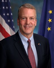 Dan Sullivan, junior United States senator
 -
 Mary Peltola, United States congresswoman
.jpg&filetimestamp=20200330045331&)
.jpg&filetimestamp=20210310123625&)


التعليم

The Alaska Department of Education and Early Development administers many school districts in Alaska. In addition, the state operates a boarding school, Mt. Edgecumbe High School in Sitka, and provides partial funding for other boarding schools, including Nenana Student Living Center in Nenana and The Galena Interior Learning Academy in Galena.[84]
There are more than a dozen colleges and universities in Alaska. Accredited universities in Alaska include the University of Alaska Anchorage, University of Alaska Fairbanks, University of Alaska Southeast, and Alaska Pacific University.[85] Alaska is the only state that has no institutions that are part of NCAA Division I.
The Alaska Department of Labor and Workforce Development operates AVTEC, Alaska's Institute of Technology.[86] Campuses in Seward and Anchorage offer one-week to 11-month training programs in areas as diverse as Information Technology, Welding, Nursing, and Mechanics.
Alaska has had a problem with a "brain drain". Many of its young people, including most of the highest academic achievers, leave the state after high school graduation and do not return. اعتبارا من 2013[تحديث], Alaska did not have a law school or medical school.[87] The University of Alaska has attempted to combat this by offering partial four-year scholarships to the top 10% of Alaska high school graduates, via the Alaska Scholars Program.[88]
الصحة العامة
The Alaska State Troopers are Alaska's statewide police force. They have a long and storied history, but were not an official organization until 1941. Before the force was officially organized, law enforcement in Alaska was handled by various federal agencies. Larger towns usually have their own local police and some villages rely on "Public Safety Officers" who have police training but do not carry firearms. In much of the state, the troopers serve as the only police force available. In addition to enforcing traffic and criminal law, wildlife Troopers enforce hunting and fishing regulations. Due to the varied terrain and wide scope of the Troopers' duties, they employ a wide variety of land, air, and water patrol vehicles.
Many rural communities in Alaska are considered "dry", having outlawed the importation of alcoholic beverages.[89] Suicide rates for rural residents are higher than urban.[90]
Domestic abuse and other violent crimes are also at high levels in the state; this is in part linked to alcohol abuse.[91] Alaska has the highest rate of sexual assault in the nation, especially in rural areas. The average age of sexually assaulted victims is 16 years old. In four out of five cases, the suspects were relatives, friends or acquaintances.[92]
الثقافة


Some of Alaska's popular annual events are the Iditarod Trail Sled Dog Race from Anchorage to Nome, World Ice Art Championships in Fairbanks, the Blueberry Festival and Alaska Hummingbird Festival in Ketchikan, the Sitka Whale Fest, and the Stikine River Garnet Fest in Wrangell. The Stikine River attracts the largest springtime concentration of American bald eagles in the world.
The Alaska Native Heritage Center celebrates the rich heritage of Alaska's 11 cultural groups. Their purpose is to encourage cross-cultural exchanges among all people and enhance self-esteem among Native people. The Alaska Native Arts Foundation promotes and markets Native art from all regions and cultures in the State, using the internet.[93]
الموسيقى
Influences on music in Alaska include the traditional music of Alaska Natives as well as folk music brought by later immigrants from Russia and Europe. Prominent musicians from Alaska include singer Jewel, traditional Aleut flautist Mary Youngblood, folk singer-songwriter Libby Roderick, Christian music singer-songwriter Lincoln Brewster, metal/post hardcore band 36 Crazyfists and the groups Pamyua and Portugal. The Man.
There are many established music festivals in Alaska, including the Alaska Folk Festival, the Fairbanks Summer Arts Festival the Anchorage Folk Festival, the Athabascan Old-Time Fiddling Festival, the Sitka Jazz Festival, and the Sitka Summer Music Festival. The most prominent orchestra in Alaska is the Anchorage Symphony Orchestra, though the Fairbanks Symphony Orchestra and Juneau Symphony are also notable. The Anchorage Opera is currently the state's only professional opera company, though there are several volunteer and semi-professional organizations in the state as well.
The official state song of Alaska is "Alaska's Flag", which was adopted in 1955; it celebrates the flag of Alaska.
في السينما والتلفزيون

رموز الولاية

- State motto: North to the Future
- Nicknames: "The Last Frontier" or "Land of the Midnight Sun" or "Seward's Icebox"
- State bird: willow ptarmigan, adopted by the Territorial Legislature in 1955. It is a small (15–17 in أو 380–430 mm) Arctic grouse that lives among willows and on open tundra and muskeg. Plumage is brown in summer, changing to white in winter. The willow ptarmigan is common in much of Alaska.
- State fish: king salmon, adopted 1962.
- State flower: wild/native forget-me-not, adopted by the Territorial Legislature in 1917.[94] It is a perennial found throughout Alaska, from Hyder to the Arctic Coast, and west to the Aleutians.
- State fossil: woolly mammoth, adopted 1986.
- State gem: jade, adopted 1968.
- State insect: four-spot skimmer dragonfly, adopted 1995.
- State land mammal: moose, adopted 1998.
- State marine mammal: bowhead whale, adopted 1983.
- State mineral: gold, adopted 1968.
- State song: "Alaska's Flag"
- State sport: dog mushing, adopted 1972.
- State tree: Sitka spruce, adopted 1962.
- State dog: Alaskan Malamute, adopted 2010.[95]
- State soil: Tanana,[96] adopted unknown.
انظر أيضاً
الهوامش
- ^ Wally Hickel would rejoin the Republican party after winning the election as a member of the Alaskan Independence Party.
- ^ Byron Mallott, the Democratic gubernatorial nominee, suspended his campaign and became the running mate of Bill Walker, an independent who left the Republican Party. They won the election with 48.1% or 134,658 votes.
المصادر
- ^ "Elevations and Distances in the United States". United States Geological Survey. 2001. Archived from the original on October 15, 2011. Retrieved October 21, 2011.
- ^ "Median Annual Household Income". The Henry J. Kaiser Family Foundation. Archived from the original on December 28, 2017. Retrieved January 27, 2018.
- ^ Barr, Wilma; Frey, Lucille (1980). Living in Alaska Yungnaqneq Alaskami. Anchorage, Alaska: National Bilingual Materials Development Center.
- ^ أ ب "QuickFacts Alaska; United States". 2018 Population Estimates. United States Census Bureau, Population Division. March 14, 2019. Archived from the original on February 5, 2019. Retrieved March 14, 2019.
- ^ Video: 49th Star. Alaska Statehood, New Flag, Official, 1959/01/05 (1959). Universal Newsreel. 1959. Archived from the original on May 15, 2012. Retrieved February 20, 2012.
- ^ "U.S. Census Bureau QuickFacts: Alaska". census.gov. Retrieved February 17, 2020.
- ^ Bergsland, Knut, ed. (1994). Aleut Dictionary: Unangam Tunudgusii. Alaska Native Language Center. ISBN 978-1-55500-047-9., at pp. 49 (Alaxsxi-x = mainland Alaska), 50 (alagu-x = sea), 508 (-gi = suffix, object of its action).
- ^ Bright, William (2007). Native American Placenames in the United States. University of Oklahoma Press. ISBN 978-0806135984.
- ^ Ransom, J. Ellis. 1940. "Derivation of the Word "Alaska", " American Anthropologist n.s., 42: pp. 550–551
- ^ "Map of Human Migration". Archived from the original on May 19, 2017. Retrieved November 5, 2016.
- ^ "Lost Native American Ancestor Revealed in Ancient Child's DNA". National Geographic. January 3, 2018. Archived from the original on January 3, 2018. Retrieved January 3, 2018.
- ^ Свердлов Л. М. Русское поселение на Аляске в XVII в.? "Природа". М., 1992. No. 4. С.67–69.
- ^ Postnikov, Alexey V. (2000). "Outline of the History of Russian Cartography". Regions: a Prism to View the Slavic Eurasian World. Archived from the original on January 17, 2013. Retrieved June 6, 2012.
- ^ Аронов В. Н. Патриарх Камчатского мореходства. // "Вопросы истории рыбной промышленности Камчатки": Историко-краеведческий сб.—Вып. 3.—2000. Вахрин С. Покорители великого океана. Петроп.-Камч.: Камштат, 1993.
- ^ The man who $old Alaska – Anchorage Daily News
- ^ Wheeler, Keith (1977). "Learning to cope with 'Seward's Icebox'". The Alaskans. Alexandria: Time–Life Books. pp. 57–64. ISBN 978-0-8094-1506-9.
- ^ these three Aleutian outer islands are about 460 ميل (740 km) away from mainland USSR, 920 ميل (1،480 km) from mainland Alaska, 950 ميل (1،530 km) from Japan.
- ^ Cloe, John Haile; Service, United States National Park (2017). Attu: the forgotten battle (in الإنجليزية). Government Printing Office. ISBN 978-0-9965837-3-2.
- ^ "Alaska—Race and Hispanic Origin: 1880 to 1990". U.S. Census Bureau. Archived from the original on December 24, 2014. Retrieved April 18, 2012.
- ^ Taylor, Alan. "1964: Alaska's Good Friday Earthquake - The Atlantic". www.theatlantic.com (in الإنجليزية). Retrieved 2021-02-04.
- ^ Alaska Heritage Resources Survey Archived مايو 13, 2014 at the Wayback Machine, Department of Natural Resources—Alaska.gov (retrieved May 9, 2014)
- ^ "Alaska Boroughs—"Official" sites". Official Borough Websites. CountyState.Info. Archived from the original on October 27, 2007. Retrieved September 13, 2007.
- ^ "Local Government". Alaska Humanities Forum. Archived from the original on November 5, 2021. Retrieved November 4, 2021.
- ^ Dixon, Mim (September 18, 2019). What Happened To Fairbanks?: The Effects of the Trans-alaska Oil Pipeline on the Community Of Fairbanks, Alaska. Routledge. ISBN 978-1-000-01076-3. Archived from the original on March 31, 2023. Retrieved November 8, 2020.
- ^ أ ب ت "2020 Census Data – Cities and Census Designated Places" (Web). State of Alaska, Department of Labor and Workforce Development. Archived from the original on August 13, 2021. Retrieved October 31, 2021.
- ^ "Places (2020): Alaska" (TXT). United States Census Bureau. Archived from the original on March 18, 2021. Retrieved October 31, 2021.
- ^ "Facts About Alaska, Alaska Kids' Corner, State of Alaska". alaska.gov. n.d. Archived from the original on January 9, 2019. Retrieved April 13, 2018.
- ^ Benson, Carl (September 2, 1998). "Alaska's Size in Perspective". Geophysical Institute, University of Alaska Fairbanks. Archived from the original on November 25, 2007. Retrieved November 19, 2007.
- ^ Porco, Peter (June 23, 2003). "Long said to be second to Fundy, city tides aren't even close". Anchorage Daily News: A1.
- ^ "Alaska Hydrology Survey". Division of Mining, Land, and Water; Alaska Department of Natural Resources. Archived from the original on March 30, 2014. Retrieved May 4, 2014.
- ^ Group, Office of Communications—OC Web. "Glacier and Landscape Change in Response to Changing Climate". www2.usgs.gov. Archived from the original on February 3, 2018. Retrieved February 2, 2018.
- ^ "Beringglacier.org". beringglacier.org. Archived from the original on January 2, 2018. Retrieved February 2, 2018.
- ^ "Travel Information on South Central Alaska". 2006. Archived from the original on April 19, 2011. Retrieved April 22, 2011.
- ^ "1927: When Ketchikan was the Largest City in Alaska". Sitnews US. April 30, 2007. Archived from the original on May 10, 2012. Retrieved July 24, 2012.
- ^ Alaska Department of Transportation and Public Facilities. "The Alaska Marine Highway System" (PDF). Alaska Department of Transportation and Public Facilities. Archived from the original (PDF) on مارس 30, 2013. Retrieved أبريل 21, 2012.
- ^ Alaska.com. "Alaska.com". Alaska.com. Archived from the original on June 3, 2010. Retrieved June 2, 2010.
- ^ Hersher, Rebecca (December 1, 2016). "Barrow, Alaska, Changes Its Name Back To Its Original 'Utqiaġvik'". National Public Radio. Retrieved December 14, 2020.
- ^ "Alaska Hydrology Survey". Division of Mining, Land, and Water; Alaska Department of Natural Resources. Archived from the original on March 30, 2014. Retrieved May 4, 2014.
- ^ Group, Office of Communications—OC Web. "Glacier and Landscape Change in Response to Changing Climate". www2.usgs.gov. Archived from the original on February 3, 2018. Retrieved February 2, 2018.
- ^ "Beringglacier.org". beringglacier.org. Archived from the original on January 2, 2018. Retrieved February 2, 2018.
- ^ "Western States Data Public Land Acreage". Wildlandfire.com. November 13, 2007. Archived from the original on July 27, 2011. Retrieved June 2, 2010.
- ^ "Alaska Land Ownership". Archived from the original on June 28, 2002. Retrieved May 4, 2014.
- ^ "Alaska climate averages". Weatherbase. Archived from the original on November 1, 2015. Retrieved November 1, 2015.
- ^ "ALASKA Population of Counties by Decennial Census: 1900 to 1990". Archived from the original on February 1, 2014. Retrieved May 18, 2014.
- ^ أ ب Population Division, Laura K. Yax. "Historical Census Statistics on Population Totals By Race, 1790 to 1990, and By Hispanic Origin, 1970 to 1990, For The United States, Regions, Divisions, and States". Archived from the original on July 25, 2008.
- ^ "Population of Alaska—Census 2010 and 2000 Interactive Map, Demographics, Statistics, Quick Facts—CensusViewer". censusviewer.com. Archived from the original on March 5, 2016. Retrieved January 6, 2014.
- ^ Center for New Media and Promotions(C2PO). "2010 Census Data". census.gov. Retrieved December 11, 2017.
{{cite web}}: CS1 maint: numeric names: authors list (link) - ^ "Adults in Alaska". Pew Research Center's Religion & Public Life Project. May 11, 2015. Archived from the original on January 14, 2016. Retrieved January 1, 2016.
- ^ "Archived copy". Archived from the original on October 15, 2019. Retrieved November 11, 2019.
{{cite web}}: CS1 maint: archived copy as title (link) - ^ Frank, Robert (January 15, 2014). "Top states for millionaires per capita". CNBC. Archived from the original on January 22, 2014. Retrieved January 22, 2014.
- ^ "EIA State Energy Profiles: Alaska". U.S. Energy Information Administration. March 27, 2014. Archived from the original on May 22, 2014. Retrieved May 21, 2014.
- ^ "Rankings: Crude Oil Production, February 2013". United States Energy Information Administration. Archived from the original on October 19, 2013. Retrieved May 19, 2014.
- ^ "ND Monthly Bakken Oil Production Statistics" (PDF). North Dakota Department of Mineral Resources. Archived (PDF) from the original on July 14, 2014. Retrieved May 21, 2014.
- ^ "Crude Oil Forecast, Markets and Transportation". Canadian Association of Petroleum Producers. June 2013. Archived from the original on May 22, 2014. Retrieved May 21, 2014.
- ^ "EIA State Energy Profiles: Alaska". Tonto.eia.doe.gov. August 27, 2009. Archived from the original on November 3, 2010. Retrieved November 7, 2010.
- ^ "Screening Report for Alaska Rural Energy Plan" (PDF). April 2001. Archived from the original (PDF) on February 16, 2008. Retrieved April 11, 2006.
- ^ "Alaska Permanent Fund Corporation". apfc.org. Archived from the original on May 20, 2007. Retrieved May 29, 2007.
- ^ "Alaska's Citizens' Dividend Set To Be Near Highest Ever". BIEN. Archived from the original on November 3, 2015. Retrieved November 3, 2015.
- ^ أ ب "Economic Forecast Released". Economic Forecast Released. Retrieved 2021-02-04.
- ^ "More than 1,000 New Farmers Markets Recorded Across Country as USDA Directory Reveals 17 Percent Growth—USDA Newsroom". Usda.gov. August 5, 2011. Archived from the original on January 17, 2013. Retrieved June 14, 2012.
- ^ "Welcome to The Alaska Peony Growers Association". Alaskapeonies.org. Archived from the original on June 30, 2012. Retrieved June 14, 2012.
- ^ "Alaska Department of Fish and Game". Adfg.alaska.gov. Archived from the original on June 24, 2011. Retrieved May 29, 2011.
- ^ "Reindeer Herding". Reindeer.salrm.uaf.edu. Archived from the original on November 19, 2010. Retrieved November 7, 2010.
- ^ "Daily Fuel Gauge Report". Automobile Association of America. Archived from the original on June 20, 2013. Retrieved May 18, 2013.
- ^ "Retail Fuel Pricing and News". Oil Price Information Service. Archived from the original on June 2, 2013. Retrieved May 18, 2013.
- ^ completion of the 3.5-ميل (5.6 km) Interstate 93 tunnel as part of the "Big Dig" project in Boston, Massachusetts.
- ^ Barbara Yaffe (January 2, 2011). "Alaska Oil / BC Tar sands via rail". Archived from the original on December 19, 2010. Retrieved January 2, 2011.
- ^ Allan Dowd (June 27, 2007). "Economic study touts Alaska-Canada rail link". Reuters. Archived from the original on July 13, 2019. Retrieved January 2, 2011.
- ^ AlaskaCanadaRail.org (January 2, 2005). "Alaska Canada Rail Link". Archived from the original on April 25, 2011. Retrieved January 2, 2011.
- ^ State of Alaska Office of Economic Development. Economic Impact of Alaska's Visitor Industry Archived مايو 22, 2014 at the Wayback Machine . January 2014. Retrieved May 21, 2014.
- ^ Out of the estimated 663,661 residents, 8,550 were pilots, or about one in 78, Federal Aviation Administration. 2005 U.S. Civil Airman Statistics Archived ديسمبر 29, 2009 at the Wayback Machine
- ^ "State of Alaska Workforce Profile Fiscal Year 2013" (PDF). Dop.state.ak.us. Archived from the original (PDF) on March 30, 2014. Retrieved May 25, 2014.
- ^ أ ب ت ث "About the Alaska Court System". State.ak.us. Archived from the original on September 13, 2009. Retrieved June 2, 2010.
- ^ Leip, David. "General Election Results—Alaska". United States Election Atlas. Archived from the original on June 4, 2011. Retrieved November 18, 2016.
- ^ https://www.elections.alaska.gov/statistics/2021/JAN/VOTERS%20BY%20PARTY%20AND%20PRECINCT.htm
- ^ CNN Money (2005). "How tax friendly is your state?" Retrieved from CNN website Archived سبتمبر 13, 2017 at the Wayback Machine.
- ^ "12 states that have either no income or sales taxes". Newsday. Archived from the original on February 15, 2019. Retrieved February 14, 2019.|
- ^ "Alaska Department of Revenue". Tax.state.ak.us. Archived from the original on June 10, 2010. Retrieved June 10, 2010.|
- ^ "How Friendly Is Your State's Tax System? The Tax Foundation's 2014 State Business Tax Climate Index". The Tax Foundation. October 9, 2013. Archived from the original on July 12, 2010. Retrieved May 25, 2014.
- ^ Cohn, Scott (July 10, 2018). "Alaska, Shackled with a 'Grave' Budget Crisis, is America's Worst State for Business". CNBC (in الإنجليزية).
- ^ Garber, Jonathan (May 8, 2020). "Plunging oil prices, coronavirus fuel budget crisis in petroleum-rich Alaska". Fox Business.
- ^ Kitchenman, Andrew (November 17, 2020). "Alaska will have a new election system: Voters pass Ballot Measure 2". KTOO. Archived from the original on November 18, 2020. Retrieved December 23, 2020.
- ^ أ ب "Alaska Ballot Measure 2, Top-Four Ranked-Choice Voting and Campaign Finance Laws Initiative (2020)". Ballotpedia. Archived from the original on November 13, 2020. Retrieved December 23, 2020.
- ^ "Asset Building in Residence Life". Alaska ICE. April 4, 2009. Archived from the original on October 9, 2007.
- ^ These are the only three universities in the state ranked by U.S. News & World Report. "Archived copy". Archived from the original on January 1, 2007. Retrieved January 3, 2007.
{{cite web}}: CS1 maint: archived copy as title (link) - ^ "AVTECHome Page". Avtec.labor.state.ak.us. Archived from the original on October 9, 2011. Retrieved September 7, 2012.
- ^ House Bill 43 'University Institutes of Law And Medicine', February 5, 2013, http://akdemocrats.org/?bill=hb43, retrieved on December 21, 2013
- ^ "UA Scholars Program—Frequently Asked Questions". Archived from the original on March 9, 2008. Retrieved December 28, 2009.
- ^ "Alaska State Troopers Alaska Bureau of Alcohol and Drug Enforcement Control Board" (PDF). Dps.state.ak.us. Archived from the original (PDF) on December 30, 2013. Retrieved May 30, 2014.
- ^ "State of Alaska". Hss.state.ak.us. Archived from the original on September 25, 2009. Retrieved June 2, 2010.
- ^ "Survey reveals higher rate of violence against Alaska women". Archived from the original on May 31, 2014. Retrieved May 30, 2014.
- ^ D'oro, Rachel (January 30, 2008). "Rural Alaska steeped in sexual violence". USA Today. Archived from the original on November 5, 2010. Retrieved December 31, 2010.
- ^ "Alaska Native Arts Foundation". alaskanativearts.org. Archived from the original on July 17, 2014. Retrieved November 28, 2019.
- ^ "Alaska Conservation Foundation—State Symbols". Archived from the original on February 25, 2009. Retrieved May 10, 2007.
- ^ "It's official: Malamute now Alaska's state dog". KTUU.com, Alaska's news and information source. May 13, 2010. Archived from the original on July 7, 2013. Retrieved June 2, 2010.
- ^ "State Soils". USDA Natural Resources Conservation Service. n.d. Archived from the original on May 1, 2017.
وصلات خارجية
- ألاسكا at Curlie
- Alaska's Digital Archives
- Alaska Inter-Tribal Council
- الفيلم القصير Alaska (1967) متاح للتنزيل المجاني على أرشيف الإنترنت [more]
 Geographic data related to ألاسكا at OpenStreetMap
- Who Owns/Manages Alaska? (map)
- Carl J. Sacarlasen Diary Extracts at Dartmouth College Library
- M.E. Diemer Alaska Photographs at Dartmouth College Library
- Alfred Hulse Brooks Photographs and Papers. Yale Collection of Western Americana, Beinecke Rare Book and Manuscript Library.
الحكومة الفدرالية الأمريكية
- Alaska State Guide from the Library of Congress
- Energy & Environmental Data for Alaska
- USGS real-time, geographic, and other scientific resources of Alaska
- US Census Bureau
- Alaska State Facts
- Alaska Statehood Subject Guide from the Eisenhower Presidential Library
- Alaska Statehood documents, Dwight D. Eisenhower Presidential Library
حكومة ولاية ألاسكا
- State of Alaska website
- Alaska State Databases
- Alaska Department of Natural Resources, Recorder's Office
| سبقه أريزونا |
قائمة الولايات الأمريكية حسب تاريخ لانضمام للاتحاد انضمت في 3 يناير 1959 (49th) |
تبعه Hawaii |
- CS1 maint: numeric names: authors list
- Pages using gadget WikiMiniAtlas
- Short description is different from Wikidata
- Articles containing ألوت-language text
- Articles containing إنوپياق-language text
- Articles containing Central Yupik-language text
- Articles containing تلنگيت-language text
- Articles containing Alutiiq-language text
- Pages using infobox settlement with no coordinates
- Articles containing إنگليزية-language text
- Pages using Lang-xx templates
- Pages including recorded pronunciations
- Articles containing روسية-language text
- Articles with hatnote templates targeting a nonexistent page
- Articles with specifically marked weasel-worded phrases from June 2020
- Pages using US Census population needing update
- جميع المقالات التي فيها عبارات متقادمة
- Pages with empty portal template
- Articles with Curlie links
- Portal-inline template with redlinked portals
- Coordinates on Wikidata
- ألاسكا
- المحيط المتجمد الشمالي
- مستعمرات روسية سابقة
- دول وأراضي تأسست في 1959
- ولايات أمريكية
- ولايات الساحل الغربي للولايات المتحدة
- ولايات بمناطق زمنية متعددة
- تأسيسات 1959 في الولايات المتحدة
- غرب الولايات المتحدة
- صفحات مع الخرائط