إدرنه
Edirne | |
|---|---|
  .JPG&filetimestamp=20210912231616&) .JPG&filetimestamp=20190405033942&)  .JPG&filetimestamp=20190405033940&) .JPG&filetimestamp=20190405033940&)  From top down, left to right: Selimiye Mosque, Meriç Bridge, Ali Pasha Bazaar, Treaty of Lausanne Monument and Museum, Trakya University (formerly Karaağaç railway station), Old Mosque, Town Hall, Historical Express | |
 Emblem of Edirne Metropolitan Municipality | |
 Edirne Location in Turkey  Edirne Location in Turkey's Marmara Region  Edirne Location in the Mediterranean Basin | |
| الإحداثيات: 41°40′37″N 26°33′20″E / 41.67694°N 26.55556°E | |
| Country | |
| المنطقة | مرمرة |
| المحافظة | إدرنه |
| الحكومة | |
| • Mayor | Recep Gürkan (CHP) |
| • Governor | Dursun Ali Şahin |
| المساحة | |
| • Province | 6٬098 كم² (2٬354 ميل²) |
| • City | 844 كم² (326 ميل²) |
| المنسوب | 42 m (138 ft) |
| التعداد | |
| • الكثافة | 196٫7/km2 (509/sq mi) |
| • Province | 407٬763 |
| • City | 165٬979 |
| منطقة التوقيت | UTC+3 (TRT) |
| Postal code | 22000 |
| مفتاح الهاتف | (+90) 284 |
| Licence plate | 22 |
إدرنه (US: /eɪˈdɪərnə, ɛˈ-/,[2][3] تركية: [eˈdiɾne]), historically known as Adrianople (/ˌeɪdriəˈnoʊpəl/; لاتينية: Hadrianopolis; founded by the Roman emperor Hadrian on the site of a previous Thracian settlement named Uskudama)[4] is a city in Turkey, in the northwestern province of Edirne and East Thrace, close to Turkey's borders with Greece and Bulgaria (3.24 miles or 5.22 kilometers from the Greek border at the closest point).[5] Edirne was the capital city of the Ottoman Empire from 1369 to 1453,[6] before Constantinople became the empire's capital. The estimated population in 2019 was 185,408.
أسس الرومان مدينة أدريانوپل في القرن الثاني الميلادي واحتلها العثمانيون في سنة 1362 م وصارت عاصمتهم من 1365 م إلى 1453 م والآن هي عاصمة المقاطعة التي تسمى أيضا بأسم أدرنة.
عدد سكانها -حسب إحصائية 2002- هو حوالي 124 ألف نسمة. من أشهر مبانيها المسجد الذي بناه السلطان سليم الثاني في 1575 م وكان قد صممه المعماري الشهير سنان ومناراته هي أعلى المنارات في تركيا وتبلغ من الإرتفاع 70.1 مترا.

الأسماء وأصولها
The city was founded as Hadrianopolis (Ἁδριανούπολις in Greek), named after the Roman emperor Hadrian. This name is still used in the modern Greek language (Αδριανούπολη, Adrianoúpoli). The Ottoman name Edrine (أدرنة) derives from the Greek name. The name Adrianople was used in English until the Turkish adoption of the Latin alphabet in 1928, upon which Edirne became the internationally recognized name. بالبلغارية: Одрин (تـُنطـَق [ˈɔdrin]), Romanian and أرومانية: [Odrina] Error: {{Lang}}: text has italic markup (help), ألبانية: Edrenë, Slovene: Odrin and بالصربية: Једрене, are all adapted forms of the name Hadrianopolis.
التاريخ

| السنة | تعداد | ±% |
|---|---|---|
| 1400s | 70٬000 | — |
| 1500s | 105٬000 | +50.0% |
| 1700s | 35٬000 | −66.7% |
| 1800s | 33٬000 | −5.7% |
| 1900s | 68٬661 | +108.1% |
| 1927 | 34٬528 | −49.7% |
| 1965 | 78٬161 | +126.4% |
| 1970 | 84٬531 | +8.1% |
| 1975 | 94٬449 | +11.7% |
| 1980 | 105٬503 | +11.7% |
| 1985 | 120٬663 | +14.4% |
| 1990 | 124٬361 | +3.1% |
| 2000 | 140٬830 | +13.2% |
| 2010 | 152٬993 | +8.6% |
| 2014 | 165٬979 | +8.5% |
The area around Edirne has been the site of numerous major battles and sieges, from the days of the Roman Empire. The vagaries of the border region between Asia and Europe gives rise to Edirne's historic claim to be the most frequently contested spot on the globe.[7]
القِدم
The city was refounded by the Roman Emperor Hadrian on the site of a previous Thracian settlement known as Uskadama, Uskudama, Uskodama or Uscudama.[4] Hadrian developed it, adorned it with monuments, and changed its name to Hadrianopolis (which would later be pronounced Adrianopolis, Anglicised as Adrianople). Licinius was defeated there by Constantine I in 324, and Emperor Valens was killed by the Goths there during the Battle of Adrianople in 378.
العصور الوسطى

In 813, the city was temporarily seized by Khan Krum of Bulgaria who moved its inhabitants to the Bulgarian lands north of the Danube.[8]
During the existence of the Latin Empire of Constantinople, the Crusaders were decisively defeated by the Bulgarian Emperor Kaloyan in the Battle of Adrianople (1205). In 1206 Adrianople and its territory was given to the Byzantine aristocrat Theodore Branas as a hereditary fief by the Latin regime.[9] Theodore Komnenos, Despot of Epirus, took possession of it in 1227, but three years later was defeated at Klokotnitsa by Emperor Ivan Asen II of Bulgaria.
In 1362, the Ottoman Empire under Sultan Murad I invaded Thrace. Murad captured Adrianople, probably in 1369 (the date is disputed). The city became "Edirne" in Turkish, reflecting the Turkish pronunciation.[10] Murad moved the Ottoman capital to Adrianople. Mehmed the Conqueror (Sultan Mehmed II) was born in Adrianople, where he came under the influence of some Hurufis dismissed by Taşköprüzade in the Şakaiki Numaniye as "Certain accursed ones of no significance", who were burnt as heretics by Mahmud Pasha.[11]
The city remained the Ottoman capital for 84 years until 1453, when Mehmed II took Constantinople (present-day Istanbul) and moved the capital there.
Edirne is famed for its many mosques, domes, minarets, and palaces from the Ottoman period.
شهدت أدرنة والمناطق المجاورة لها ما لا يقل عن 16 معركة حاسمة عبر العصور وتبادل حكمها عدة دول من ضمنها روسيا مرتين في القرن التاسع عشر وبلغاريا في 1912 م.
ومن المعارك المهمة التي وقعت على مشارفها المعركة التي هُزِمت فيها القوات الرومانية على يد القوط الغربيين في عام 378م، مما أدى إلى فتح بلاد الإغريق للأجانب غير اليونانيين. ثم استولى العثمانيون على المدينة في عام 1360م. استولت عليها القوات الروسية من الأتــراك بـين عامي 1829 و1878م، واحتل البلغاريون المدينة خلال حرب البلقان الأولى.
السلطان محمد الثاني، فاتح القسطنطينية، وُلِد في إدرنه.
بهاء الله، مؤسس البهائية، عاش في إدرنه من 1863 حتى 1868. وكان منفياً هناك من قِبل الدولة العثمانية قبل أن تـُشدد عقوبته بالنفي إلى المنفى الجماعي العثماني في عكا.

العصر الحديث

Under Ottoman rule, Adrianople was the principal city of the administrative unit, the eponymous Eyalet of Adrianople, and after land reforms in 1867, the Vilayet of Adrianople.
Sultan Mehmed IV left the palace in Constantinople and died in Adrianople in 1693.
During his exile in the Ottoman Empire, the Swedish king Charles XII stayed in the city during most of 1713.[12]
Baháʼu'lláh, the founder of the Baháʼí Faith, lived in Edirne from 1863 to 1868. He was exiled there by the Ottoman Empire before being banished further to the Ottoman penal colony in Akka. He referred to Adrianople in his writings as the "Land of Mystery".[13]
Adrianople was a sanjak centre during the Ottoman period and was bound to, successively, the Rumeli Eyalet and Silistre Eyalet before becoming a provincial capital of the Eyalet of Edirne at the beginning of the 19th century; until 1878, the Eyalet of Adrianople comprised the sanjaks of Edirne, Tekfurdağı, Gelibolu, Filibe, and İslimye.
Adrianople was briefly occupied by imperial Russian troops in 1829 during the Greek War of Independence and in 1878 during the Russo-Turkish War of 1877–1878. The city suffered a fire in 1905. In 1905 it had about 80,000 inhabitants, of whom 30,000 were Turks; 22,000 Greeks; 10,000 Bulgarians; 4,000 Armenians; 12,000 Jews; and 2,000 more citizens of unclassified ethnic/religious backgrounds.[citation needed]
Adrianople was a vital fortress defending Ottoman Constantinople and Eastern Thrace during the Balkan Wars of 1912–13. It was briefly occupied by the Bulgarians in 1913, following the Siege of Adrianople. The Great Powers–Britain, Italy, France, and Russia–attempted to coerce the Ottoman Empire into ceding Adrianople to Bulgaria during the temporary winter truce of the First Balkan War. The belief that that government was willing to give up the city created a political scandal in the Ottoman government in Constantinople (as Adrianople was a former capital of the Empire), leading to the 1913 Ottoman coup d'état. Although it was victorious in the coup, the Committee of Union and Progress under Enver Pasha was unable to stop the Bulgarians from capturing the city after the fighting resumed in the Spring. Despite relentless pressure from the Great powers (Russia, Britain, France) the Ottoman empire never officially ceded the city to Bulgaria. Edirne was swiftly reconquered by the Ottoman empire during the Second Balkan War under the leadership of Enver Pasha (who would proclaim himself the "second conqueror of Adrianople", after Murad I) following the total collapse of the Bulgarian military might in the region.
The entire Armenian population of the city was deported during the Armenian genocide on 27–28 October 1915 and 17–18 February 1916, ending up in Syria and Mesopotamia. Their property and businesses were sold at low prices to Turkish Muslims.[14]
It was ceded to Greece by the Treaty of Sèvres in 1920, but recaptured and annexed by Turkey after the decisive Greek defeat at the end of the Greco-Turkish War, also known as the Western Front of the larger Turkish War of Independence, in 1922. During the Greek administration, Edirne (officially known as Adrianople) was the capital of the Adrianople Prefecture.
Adrianople became known in Western languages as "Edirne" circa 1930.[15] From 1934 onwards Edirne was the seat of the Second Inspectorate General, in which an Inspector General governed the provinces Edirne, Çanakkale, Tekirdaĝ and Kırklareli.[16] The Inspectorate Generals governmental posts were abandoned in 1948,[17] but the legal framework of them was only abolished in 1952, under the government of the Democrat Party.[18]
According to the 2007 census, Edirne Province had a population of 382,222 inhabitants. The city is a commercial centre for woven textiles, silks, carpets and agricultural products.

الجغرافيا
المناخ
Edirne has a borderline humid subtropical (Cfa) and hot-summer Mediterranean climate (Csa) in the Köppen climate classification, and a temperate oceanic climate (Do) in the Trewartha climate classification. Edirne has hot, moderately dry summers and chilly, wet and often snowy winters.
| بيانات المناخ لـ Edirne (1991–2020, extremes 1930–2020) | |||||||||||||
|---|---|---|---|---|---|---|---|---|---|---|---|---|---|
| الشهر | ينا | فب | مار | أبر | ماي | يون | يول | أغس | سبت | أكت | نوف | ديس | السنة |
| القصوى القياسية °س (°ف) | 20.5 (68.9) |
23.3 (73.9) |
28.0 (82.4) |
33.5 (92.3) |
37.1 (98.8) |
42.6 (108.7) |
44.1 (111.4) |
41.9 (107.4) |
39.9 (103.8) |
35.8 (96.4) |
28.0 (82.4) |
22.8 (73.0) |
44.1 (111.4) |
| متوسط القصوى اليومية °س (°ف) | 7.1 (44.8) |
10.2 (50.4) |
14.3 (57.7) |
19.8 (67.6) |
25.5 (77.9) |
30.1 (86.2) |
32.7 (90.9) |
33.1 (91.6) |
27.9 (82.2) |
21.0 (69.8) |
14.4 (57.9) |
8.4 (47.1) |
20.4 (68.7) |
| المتوسط اليومي °س (°ف) | 2.8 (37.0) |
4.8 (40.6) |
8.3 (46.9) |
13.2 (55.8) |
18.5 (65.3) |
22.9 (73.2) |
25.3 (77.5) |
25.4 (77.7) |
20.6 (69.1) |
14.8 (58.6) |
9.3 (48.7) |
4.4 (39.9) |
14.2 (57.6) |
| متوسط الدنيا اليومية °س (°ف) | −0.4 (31.3) |
0.7 (33.3) |
3.5 (38.3) |
7.3 (45.1) |
12.1 (53.8) |
16.1 (61.0) |
18.2 (64.8) |
18.3 (64.9) |
14.2 (57.6) |
9.9 (49.8) |
5.4 (41.7) |
1.2 (34.2) |
8.9 (48.0) |
| الصغرى القياسية °س (°ف) | −19.5 (−3.1) |
−19.0 (−2.2) |
−12.0 (10.4) |
−4.1 (24.6) |
0.7 (33.3) |
6.0 (42.8) |
8.0 (46.4) |
8.9 (48.0) |
0.2 (32.4) |
−3.7 (25.3) |
−9.4 (15.1) |
−14.9 (5.2) |
−19.5 (−3.1) |
| متوسط تساقط الأمطار mm (inches) | 65.8 (2.59) |
53.3 (2.10) |
52.8 (2.08) |
44.0 (1.73) |
57.5 (2.26) |
46.0 (1.81) |
39.6 (1.56) |
24.0 (0.94) |
39.2 (1.54) |
66.1 (2.60) |
66.4 (2.61) |
70.5 (2.78) |
625.2 (24.61) |
| Average precipitation days | 10.50 | 9.57 | 11.57 | 11.23 | 11.70 | 9.90 | 6.47 | 4.57 | 6.40 | 8.90 | 10.00 | 11.47 | 112.3 |
| Mean monthly ساعات سطوع الشمس | 68.2 | 98.9 | 130.2 | 171.0 | 229.4 | 255.0 | 288.3 | 279.0 | 198.0 | 136.4 | 87.0 | 58.9 | 2٬000٫3 |
| المتوسط اليومي ساعات سطوع الشمس | 2.2 | 3.5 | 4.2 | 5.7 | 7.4 | 8.5 | 9.3 | 9.0 | 6.6 | 4.4 | 2.9 | 1.9 | 5.5 |
| Source: Turkish State Meteorological Service[19] | |||||||||||||
المعالم

.JPG&filetimestamp=20210912231615&)

.JPG&filetimestamp=20210912231614&)
الثقافة والشراكة مع اوروبا


الاقتصاد
من جملة ما تشتهر به إدرنه صناعة الجبن الأبيض وصناعة الصابون.
معرض صور

Interior view of the Grand Synagogue of Edirne
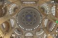
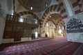
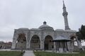
Interior view of the Selimiye Mosque, Edirne
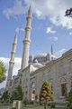
View of the Selimiye Mosque, Edirne
View of the Selimiye Mosque, Edirne
A house in Edirne from the Ottoman period
Interior of Eski Cami
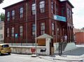
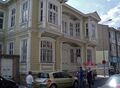
A historic elementary school building

Edirne Main Street
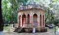
IV.Mehmet Hunting Kiosk
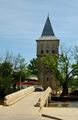
Fatih Bridge over the Tunca River, with the Kasr-ı Adalet (Justice Pavilion) tower seen in the background

Ghazi Mihal Mosque
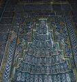
Part of Muradiye Mosque mihrab
Muradiye Mosque front

A Roman Tower still standing
.JPG&filetimestamp=20210912231613&)


.JPG&filetimestamp=20210912231622&)
.JPG&filetimestamp=20210912231622&)


.jpg&filetimestamp=20210912231619&)
,_Front.jpg&filetimestamp=20090529232330&)


.JPG&filetimestamp=20210912231615)
.JPG&filetimestamp=20210912231614)
انظر أيضاً
البلدات التوأم
أشخاص بارزون
- Sultans
- Bayezid I (1360—1403), Ottoman sultan from 1389 to 1402
- Mahmud I (1696—1754), Ottoman sultan from 1730 to 1754
- Mehmed the Conqueror (1432–1481), Ottoman sultan who conquered Constantinople (today Istanbul)
- Mustafa II (1664–1703), Ottoman sultan from 1695 to 1703
- Osman III (1699—1757), Ottoman sultan from 1754 to 1757
- Şahin Giray (1745-1787), last khan of Crimea
- تاريخيا
- Caleb Afendopolo (before 1430-1499), Jewish polyhistor
- Athanasius I of Constantinople (1230—1310), Ecumenical Patriarch of Constantinople
- Athanasius V of Jerusalem (died 1844), Greek Orthodox Patriarch of Jerusalem
- Hagop Baronian (1843—1891), Ottoman Armenian writer, satirist, educator
- Elijah Bashyazi (c. 1420—1490), Karaite Jewish hakham
- Theodore Branas, Byzantine general
- Nikephoros Bryennios (ethnarch), Byzantine general
- Abraham ben Raphael Caro, 18th-century Ottoman rabbi
- Karpos Papadopoulos (1790s-1871), Member of the Filiki Eteria
- Theoklitos Polyeidis (1698-1759), Greek scholar, teacher, translator, priest and monk
- Dionysius V of Constantinople (1820-1891), Ecumenical Patriarch of Constantinople
- Joseph Halévy (1827—1917), Ottoman-born Jewish-French Orientalist and traveler
- Abdulcelil Levni (died 1732), Ottoman court painter and miniaturist
- Neşâtî (?–1674), Ottoman poet
- Georgi Valkovich (1833—1892), Bulgarian physician, diplomat and politician
- Yirmisekiz Mehmed Çelebi (died 1732), Ottoman statesman and ambassador
- Stefanos Koumanoudis (1818-1899), Greek archaeologist, university teacher, writer and translator
- معاصرون
- Cem Adrian (born 1980), Turkish singer-songwriter, author, producer and film director
- Şevket Süreyya Aydemir (1897—1976), Turkish writer, intellectual, economist, historian
- Atılay Canel (born 1955), Turkish football coach
- Cavit Erdel (1884—1933), Ottoman Army officer and Turkish Army general
- Hüsrev Gerede (1884-1962), Ottoman and Turkish Army officer, politician and diplomat
- Avra Theodoropoulou (1880-1863), Greek musician and activist
- Ragıp Gümüşpala (1897-1964), 11th Chief of the General Staff of the Turkish Armed Forces
- Acun Ilıcalı (born 1969), Turkish television personality and producer
- Haşim İşcan (1898-1968), Turkish high school teacher, province governor and the first elected mayor of Istanbul
- Kemal Kerinçsiz (born 1960), Turkish ultra-nationalist lawyer
- Özlem Kolat (born 1984), Turkish classical clarinet player
- Michael Petkov (1850-1921), Bulgarian Eastern Catholic priest
- Muharrem Korhan Yamaç (born 1972), Paralympics, world and European champion disabled sport shooter
- Nikos Zachariadis (1903—1973), General Secretary of the Communist Party of Greece
- Gökberk Ergeneman (born 1995) National Tennis Player
انظر أيضاً
المراجع
https://www.academia.edu/23674853/Edirne_Ta%C5%9F_K%C3%B6pr%C3%BCleri_Edirne_Stone_Bridges
- ^ "HGK" (PDF). General Command of Mapping.
- ^ "Edirne". Collins English Dictionary. HarperCollins. Retrieved 3 August 2019.
- ^ قالب:Cite Merriam-Webster
- ^ أ ب "Edirne". Encyclopaedia Britannica. Retrieved 31 May 2018.
- ^ "Google Maps". Google Maps (in الإنجليزية). Retrieved 2021-07-25.
- ^ "In 1363 the Ottoman capital moved from Bursa to Edirne, although Bursa retained its spiritual and economic importance." Ottoman Capital Bursa. Official website of Ministry of Culture and Tourism of the Republic of Turkey. Retrieved 19 December 2014. Contradicted by refs cited in Conquest of Adrianople
- ^ Keegan, John (1993). A History of Warfare. Random House. pp. 70–71. ISBN 0-7126-9850-7.
- ^ Hupchick, Dennis (2017). The Bulgarian-Byzantine Wars for Early Medieval Balkan Hegemony: silver-lined skulls and blinded armies. US: Palgrave Macmillan. p. 107. ISBN 9783319562056.
- ^ Saint-Guillain, G. (1216) Identities and Allegiances in the Eastern Mediterranean after 1204, Routledge, p. 66
- ^ "It served as the capital of the Ottoman Empire from 1413 until 1458 and flourished as an administrative, commercial, and cultural centre." "Edirne" Encyclopædia Britannica. Retrieved 19 December 2014
- ^ John Kingsley Birge, The Bektashi Order of Dervishes, 1982 (p 60 - 62)
- ^ "Adrianopel" in Nordisk familjebok (2nd edition, 1904)
- ^ "Bahaʼi Reference Library - The Kitáb-i-Aqdas, Page 196". Reference.bahai.org. 31 December 2010. Retrieved 30 July 2011.
- ^ Kévorkian, Raymond (2011). The Armenian Genocide: A Complete History (in الإنجليزية). Bloomsbury Publishing. pp. 546–548. ISBN 978-0-85771-930-0.
- ^ Romein, Jan (translated by R. T. Clark). The Asian Century: A History of Modern Nationalism in Asia (De eeuw van Azie). University of California Press, 1962. p. 170. "In 1930 geographical names were 'turkicized'. [...] Adrianople Edirne, and so on."
- ^ Cagaptay, Soner (2006). Islam, Secularism, and Nationalism in Modern Turkey; Who is a Turk. Routledge. p. 47.
- ^ Bayir, Derya (2016-04-22). Minorities and Nationalism in Turkish Law (in الإنجليزية). Routledge. p. 141. ISBN 978-1-317-09579-8.
- ^ Bozarslan, Hamit (2008-04-17). Fleet, Kate; Faroqhi, Suraiya; Kasaba, Reşat; Kunt, I. Metin (eds.). The Cambridge History of Turkey (in الإنجليزية). Cambridge University Press. p. 343. ISBN 978-0-521-62096-3.
- ^ "Resmi İstatistikler: İllerimize Ait Mevism Normalleri (1991–2020)" (in التركية). Turkish State Meteorological Service. Archived from the original on 11 January 2019. Retrieved 11 April 2021.
خطأ استشهاد: الوسم <ref> ذو الاسم "h1" المُعرّف في <references> غير مستخدم في النص السابق.
خطأ استشهاد: الوسم <ref> ذو الاسم "cnnt1" المُعرّف في <references> غير مستخدم في النص السابق.
خطأ استشهاد: الوسم <ref> ذو الاسم "s1" المُعرّف في <references> غير مستخدم في النص السابق.
<ref> ذو الاسم "evdb3" المُعرّف في <references> غير مستخدم في النص السابق.للاستزادة
- Gökbilgin, M. Tayyib (1991). "Edirne". Encyclopaedia of Islam, Volume 2 (2nd ed.). Leiden: Brill. pp. 683–686. ISBN 90-04-07026-5.
- Wasti, Syed Tanvir (July 2004). "The 1912-13 Balkan Wars and the Siege of Edirne". Middle Eastern Studies. Taylor & Francis, Ltd. 40 (4): 59–78. doi:10.1080/00263200410001700310. JSTOR 4289928. S2CID 145595992.
- Yerolympous, Alexandra. "A Contribution to the Topography of 19th Century Adrianople". Balkan Studies: 49–72.
وصلات خارجية
- Edirne Stone Bridges - "History of Edirne"
- Edirne Directory
- GCatholic.org
- Edirne Weather Forecast Information
- Photographs of the town and monuments taken by Disk Osseman
- Awarded "EDEN - European Destinations of Excellence" non-traditional tourist destination 2008
| المقاطعات الحضرية |  | |
|---|---|---|
| المقاطعات الريفية | ||
المناطق | ||
| إيجه | ||
| البحر الأسود | ||
| وسط الأناضول | ||
| شرق الأناضول | ||
| مرمرة | ||
| البحر المتوسط | ||
| جنوب شرق الأناضول | ||
- Pages using gadget WikiMiniAtlas
- CS1 التركية-language sources (tr)
- Articles with hatnote templates targeting a nonexistent page
- Missing redirects
- Short description is different from Wikidata
- Coordinates on Wikidata
- Pages with plain IPA
- Articles containing لاتينية-language text
- Pages using Lang-xx templates
- Articles containing Ancient Greek (to 1453)-language text
- Articles containing Greek-language text
- Articles containing بلغارية-language text
- Lang and lang-xx template errors
- Articles containing ألبانية-language text
- Articles containing Slovene-language text
- Articles containing صربية-language text
- Articles with unsourced statements from April 2017
- محافظة إدرنه
- مدن تركيا
- منطقة مرمرة
- إدرنه
- Catholic titular sees in Europe
- عواصم وطنية سابقة
- Jewish communities in Turkey
- أماكن مأهولة تأسست في القرن الثاني
- مواقع رومانية في تركيا
- معسكرات الفيالق الرومانية في البلقان
- Titular sees in Europe