قانسو
| ||||||||||||||||||||||||||||||||||||||||||||||||||||||||||||||||||||||||||
| ||||||||||||||||||||||||||||||||||||||||||||||||||||||||||||||||||||||||||


.jpg&filetimestamp=20220630023515&)


.svg&filetimestamp=20200825060937&)
.svg&filetimestamp=20200825060935&)
گانسو (صينية مبسطة: 甘肃; صينية تقليدية: 甘肅; پنين: Gānsù; ويد-گايلز: Kan-su, Kansu, or Kan-suh) هي مقاطعة تقع في الشمال الغربي لجمهورية الصين الشعبية. وتقع بين چينگهاي ومنغوليا الداخلية و Huangtu Plateaus, وتحدها منغوليا إلى الشمال وشينجيانگ إلى الغرب. النهر الأصفر يمر عبر الجزء الجنوبي من المقاطعة. ويبلغ عدد سكانها نحو 26 مليون (2004) وبها نسبة تركز عالية من الصينيين الهوي. عاصمة المقاطعة هي لانژو, التي تقع في الجزء الجنوبي الشرقي من گانسو. گانسو كثيراً ما تُختصر إلى گان Gan أو لونگ Long (陇/隴), وتـُعرف كذلك باسم غرب جبال لونگ Long West أو يمين جبال لونگ Long Right, وتلك الجبال تقع إلى الشرق من گانسو. Part of Gansu's territory is located in the Gobi Desert. The Qilian mountains are located in the south of the Province.
Gansu has a population of 26 million, ranking 22nd in China. Its population is mostly Han, along with Hui, Dongxiang and Tibetan minorities. The most common language is Mandarin. Gansu is among the poorest administrative divisions in China, ranking 31st in GDP per capita. Most of Gansu's economy is based on the mining industry and the extraction of minerals, especially rare earth elements. Tourism also plays a role in Gansu's economy.
The State of Qin originated in what is now southeastern Gansu and went on to form the first known Empire in what is now China. The Northern Silk Road ran through the Hexi Corridor, which passes through Gansu, resulting in it being an important strategic outpost and communications link for the Chinese empire.
The city of Jiayuguan, the second most populated city in Gansu, is known for its section of the Great Wall and the Jiayuguan Pass fortress complex.
الاسم
گانسو هو اسم مركـَّب استـُعمِل لأول مرة في أسرة سونگ الصين, من محافظتين من أسرتي سوي و تانگ (州): Gan (around Zhangyi) and Su (around Jiuquan).
Gansu is a compound of the names of Gānzhou (now the main urban district and seat of Zhangye) and Sùzhou (an old name and the modern seat of Jiuquan), formerly the two most important Chinese settlements in the Hexi Corridor.
Gansu is abbreviated as "甘" (Gān) or "陇" (Lǒng), and was also known as Longxi (陇西; '[land] west of Long') or Longyou (陇右; '[land] right of Long') prior to early Western Han dynasty, in reference to the Long Mountain (the modern day Liupan Mountain's southern section) between eastern Gansu and western Shaanxi. [citation needed]
التاريخ

Gansu's name is a compound name first used during the Song dynasty. It is a combination of the names of two prefecture (州) in the Sui and Tang dynasty: Gan (around Zhangye) and Su (around Jiuquan). Its eastern part forms part of one of the cradles of ancient Chinese civilisation.
گانسو القديمة
In prehistoric times, Gansu was host to Neolithic cultures. The Dadiwan culture, from where archaeologically significant artifacts have been excavated, flourished in the eastern end of Gansu from about 6000 BC to about 3000 BC.[6] The Majiayao culture and part of the Qijia culture took root in Gansu from 3100 BC to 2700 BC and 2400 BC to 1900 BC respectively.
The Yuezhi originally lived in the very western part of Gansu until they were forced to emigrate by the Xiongnu around 177 BCE.
The State of Qin, known in China as the founding state of the Chinese empire, grew out from the southeastern part of Gansu, specifically the Tianshui area. The Qin name is believed to have originated, in part, from the area.[7][8] Qin tombs and artifacts have been excavated from Fangmatan near Tianshui, including one 2200-year-old map of Guixian County.[9]
العصر الامبراطوري


In imperial times, Gansu was an important strategic outpost and communications link for the Chinese empire, as the Hexi Corridor runs along the "neck" of the province. The Han dynasty extended the Great Wall across this corridor, building the strategic Yumenguan (Jade Gate Pass, near Dunhuang) and Yangguan fort towns along it. Remains of the wall and the towns can be found there. The Ming dynasty built the Jiayuguan outpost in Gansu. To the west of Yumenguan and the Qilian Mountains, at the northwestern end of the province, the Yuezhi, Wusun, and other nomadic tribes dwelt (Shiji 123), occasionally figuring in regional imperial Chinese geopolitics.
By the Qingshui treaty, concluded in 823 between the Tibetan Empire and the Tang dynasty, China lost much of western Gansu province for a significant period.[10]
After the fall of the Uyghur Khaganate, a Buddhist Yugur (Uyghur) state called the Ganzhou Uyghur Kingdom was established by migrating Uyghurs from the Khaganate in part of Gansu that lasted from 848 to 1036 AD.
Along the Silk Road, Gansu was an economically important province, as well as a cultural transmission path. Temples and Buddhist grottoes[11] such as those at Mogao Caves ('Caves of the Thousand Buddhas') and Maijishan Caves contain artistically and historically revealing murals.[12] An early form of paper inscribed with Chinese characters and dating to about 8 BC was discovered at the site of a Western Han garrison near the Yumen pass in August 2006.[13]
The Xixia or Western Xia dynasty controlled much of Gansu as well as Ningxia.
The province was also the origin of the Dungan Revolt of 1862–77. Among the Qing forces were Muslim generals, including Ma Zhan'ao and Ma Anliang, who helped the Qing crush the rebel Muslims. The revolt had spread into Gansu from neighbouring Qinghai.
There was another Dungan revolt from 1895 to 1896.
الصين الجمهورية
As a result of frequent earthquakes, droughts and famines, the economic progress of Gansu was significantly slower than that of other provinces of China until recently. Based on the area's abundant mineral resources it has begun developing into a vital industrial center. An earthquake in Gansu at 8.6 on the Richter scale killed around 180,000 people mostly in the present-day area of Ningxia in 1920, and another with a magnitude of 7.6 killed 275 in 1932.[14]
The Muslim Conflict in Gansu (1927–1930) was a conflict against the Guominjun.
While the Muslim General Ma Hongbin was acting chairman of the province, Muslim General Ma Buqing was in virtual control of Gansu in 1940. Liangzhou District in Wuwei was previously his headquarters in Gansu, where he controlled 15 million Muslims.[15] Xinjiang came under Kuomintang (Nationalist) control after their soldiers entered via Gansu.[16] Gansu's Tienshui was the site of a Japanese-Chinese warplane fight.[17]
Gansu was vulnerable to Soviet penetration via Xinjiang.[18] Gansu was a passageway for Soviet supplies during the Second Sino-Japanese War.[19] Lanzhou was a destination point via a road coming from Dihua (Ürümqi).[20] Lanzhou and Lhasa were designated to be recipients of a new railway.[when?][21]
The Kuomintang Islamic insurgency in China (1950–1958) was a prolongation of the Chinese Civil War in several provinces including Gansu.
الجغرافيا


Gansu has an area of 454،000 متر كيلومربع (175،000 sq mi), and the vast majority of its land is more than 1،000 متر (3،300 ft) above sea level. It lies between the Tibetan Plateau and the Loess Plateau, bordering Mongolia (Govi-Altai Province) to the northwest, Inner Mongolia and Ningxia to the north, Shaanxi to the east, Sichuan to the south, and Xinjiang to the west. The Yellow River passes through the southern part of the province. The province contains the geographical centre of China, marked by the Center of the Country Monument at 35°50′40.9″N 103°27′7.5″E / 35.844694°N 103.452083°E.[22]
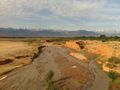
Part of the Gobi Desert is located in Gansu, as well as small parts of the Badain Jaran Desert and the Tengger Desert.
The Yellow River gets most of its water from Gansu, flowing straight through Lanzhou. The area around Wuwei is part of Shiyang River Basin.[23]
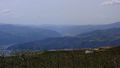
The landscape in Gansu is very mountainous in the south and flat in the north. The mountains in the south are part of the Qilian Mountains, while the far western Altyn-Tagh contains the province's highest point, at 5،830 متر (19،130 ft).
A natural land passage known as Hexi Corridor, stretching some 1،000 كيلومتر (620 mi) from Lanzhou to the Jade Gate, is situated within the province. It is bound from north by the Gobi Desert and Qilian Mountains from the south.
Gansu generally has a semi-arid to arid continental climate (Köppen BSk or BWk) with warm to hot summers and cold to very cold winters, although diurnal temperature ranges are often so large that maxima remain above 0 °C (32 °F) even in winter. However, due to extreme altitude, some areas of Gansu exhibit a subarctic climate (Dwc) – with winter temperatures sometimes dropping to −40 °C (−40 °F). Most of the limited precipitation is delivered in the summer months: winters are so dry that snow cover is confined to very high altitudes and the snow line can be as high as 5،500 متر (18،040 ft) in the southwest.
-
-
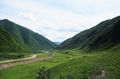
 Qilian Mountains southeast of Jiuquan
 -
 Terrace farms near Tianshui
 -
 Grasslands in Min County
 -
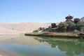
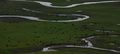 Wetland by the Yellow River, Maqu County

.jpg&filetimestamp=20200825060943&)


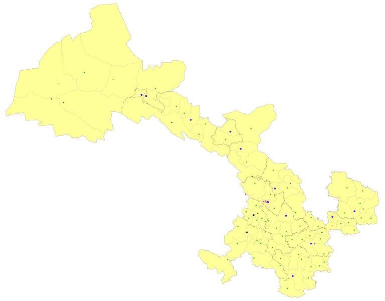
التقسيمات الإدارية
Gansu is divided into fourteen prefecture-level divisions: twelve prefecture-level cities and two autonomous prefectures:
| التقسيمات الادارية لـگانسو | |||||||||||
|---|---|---|---|---|---|---|---|---|---|---|---|
| Division code[24] | Division | Area in km2[25] | Population 2010[26] | Seat | Divisions[27] | ||||||
| Districts | Counties | Aut. counties | CL cities | ||||||||
| 620000 | Gansu Province | 425800.00 | 25,575,254 | Lanzhou city | 17 | 58 | 7 | 4 | |||
| 620100 | Lanzhou city | 13,103.04 | 3,616,163 | Chengguan District | 5 | 3 | |||||
| 620200 | Jiayuguan city* | 2,935.00 | 231,853 | Shengli Subdistrict | |||||||
| 620300 | Jinchang city | 7,568.84 | 464,050 | Jinchuan District | 1 | 1 | |||||
| 620400 | Baiyin city | 20,164.09 | 1,708,751 | Baiyin District | 2 | 3 | |||||
| 620500 | Tianshui city | 14,312.13 | 3,262,548 | Qinzhou District | 2 | 4 | 1 | ||||
| 620600 | Wuwei city | 32,516.91 | 1,815,054 | Liangzhou District | 1 | 2 | 1 | ||||
| 620700 | Zhangye city | 39,436.54 | 1,199,515 | Ganzhou District | 1 | 4 | 1 | ||||
| 620800 | Pingliang city | 11,196.71 | 2,068,033 | Kongtong District | 1 | 6 | |||||
| 620900 | Jiuquan city | 193,973.78 | 1,095,947 | Suzhou District | 1 | 2 | 2 | 2 | |||
| 621000 | Qingyang city | 27,219.71 | 2,211,191 | Xifeng District | 1 | 7 | |||||
| 621100 | Dingxi city | 19,646.14 | 2,698,622 | Anding District | 1 | 6 | |||||
| 621200 | Longnan city | 27,856.69 | 2,567,718 | Wudu District | 1 | 8 | |||||
| 622900 | Linxia Hui Autonomous Prefecture | 8,116.57 | 1,946,677 | Linxia city | 5 | 2 | 1 | ||||
| 623000 | Gannan Tibetan Autonomous Prefecture | 38,311.56 | 689,132 | Hezuo city | 7 | 1 | |||||
| * – direct-piped cities – does not contain any county-level divisions | |||||||||||
| Administrative divisions in Chinese and varieties of romanizations | ||||
|---|---|---|---|---|
| English | Chinese | Pinyin | ||
| Gansu Province | 甘肃省 | Gānsù Shěng | ||
| Lanzhou city | 兰州市 | Lánzhōu Shì | ||
| Jiayuguan city | 嘉峪关市 | Jiāyùguān Shì | ||
| Jinchang city | 金昌市 | Jīnchāng Shì | ||
| Baiyin city | 白银市 | Báiyín Shì | ||
| Tianshui city | 天水市 | Tiānshuǐ Shì | ||
| Wuwei city | 武威市 | Wǔwēi Shì | ||
| Zhangye city | 张掖市 | Zhāngyè Shì | ||
| Pingliang city | 平凉市 | Píngliáng Shì | ||
| Jiuquan city | 酒泉市 | Jiǔquán Shì | ||
| Qingyang city | 庆阳市 | Qìngyáng Shì | ||
| Dingxi city | 定西市 | Dìngxī Shì | ||
| Longnan city | 陇南市 | Lǒngnán Shì | ||
| Linxia Hui Autonomous Prefecture | 临夏回族自治州 | Línxià Huízú Zìzhìzhōu | ||
| Gannan Tibetan Autonomous Prefecture | 甘南藏族自治州 | Gānnán Zàngzú Zìzhìzhōu | ||
The fourteen Prefecture of Gansu are subdivided into 82 county-level divisions (17 districts, 4 county-level cities, 58 counties, and 3 autonomous counties).
المناطق الحضرية
| Population by urban areas of prefecture & county cities | |||||
|---|---|---|---|---|---|
| # | City | Urban area[28] | District area[28] | City proper[28] | Census date |
| 1 | Lanzhou | 2,438,595 | 2,628,426 | 3,616,163 | 2010-11-01 |
| 2 | Tianshui | 544,441 | 1,197,174 | 3,262,549 | 2010-11-01 |
| 3 | Baiyin | 362,363 | 486,799 | 1,708,752 | 2010-11-01 |
| 4 | Wuwei | 331,370 | 1,010,295 | 1,815,059 | 2010-11-01 |
| 5 | Jiuquan | 255,739 | 428,346 | 1,095,947 | 2010-11-01 |
| 6 | Pingliang | 248,421 | 504,848 | 2,068,033 | 2010-11-01 |
| 7 | Linxia | 220,895 | 274,466 | part of Linxia Prefecture | 2010-11-01 |
| 8 | Zhangye | 216,760 | 507,433 | 1,199,515 | 2010-11-01 |
| 9 | Jiayuguan | 216,362 | 231,853 | 231,853 | 2010-11-01 |
| 10 | Jinchang | 195,409 | 228,561 | 464,050 | 2010-11-01 |
| 11 | Qingyang | 181,780 | 377,528 | 2,211,191 | 2010-11-01 |
| 12 | Dingxi | 158,062 | 420,614 | 2,698,624 | 2010-11-01 |
| 13 | Longnan | 136,468 | 555,004 | 2,567,718 | 2010-11-01 |
| 14 | Dunhuang | 111,535 | 186,027 | see Jiuquan | 2010-11-01 |
| (15) | Huating[أ] | 88,454 | 189,333 | see Pingliang | 2010-11-01 |
| 16 | Yumen | 78,940 | 159,792 | see Jiuquan | 2010-11-01 |
| 17 | Hezuo | 57,384 | 90,290 | see Gannan Prefecture | 2010-11-01 |
- ^ Huating County is currently known as Huating CLC after census.
مشروع مكافحة التصحر
بنك التنمية الآسيوي يعمل حالياً مع State Forestry Administration of China on the Silk Road Ecosystem Restoration project, designed to prevent degradation and desertification in Gansu. It is estimated to cost up to US$150 million.
السياسة

Secretaries of the CPC Gansu Committee: The Secretary of the CPC Gansu Committee is the highest ranking office within Gansu Province. [29]
- Zhang Desheng (张德生): 1949-1954
- Zhang Zhongliang (张仲良): 1954-1961
- Wang Feng (汪锋): 1961-1966
- Hu Jizong (胡继宗): 1966-1967
- Xian Henghan (冼恒汉): 1970-1977
- Song Ping (宋平): 1977-1981
- Feng Jixin (冯纪新): 1981-1983
- Li Ziqi (李子奇): 1983-1990
- Gu Jinchi (顾金池): 1990-1993
- Yan Haiwang (阎海旺): 1993-1998
- Sun Ying (孙英): 1998-2001
- Song Zhaosu (宋照肃): 2001-2003
- Su Rong (苏荣): 2003-2007
- Lu Hao (陆浩): April 2007[29] - incumbent
الاقتصاد

الانتاج الزراعي يضم القطن, زيت بذرة الكتان, الذرة, البطيخ (شمام بايلان له شهيرة كبيرة في أرجاء الصين), millet, و القمح. وتشتهر گانسو كمصدر للأعشاب الطبية البرية التي تـُستخدم في الطب الصيني.
إلا أن معظم اقتصاد گانسو يعتمد على التعدين واستخراج المعادن, وخاصة العناصر الترابية النادرة. وتحتوي المقاطعة على رواسب هامة من الأنتيمون, الكروم والفحم والكوبالت والنحاس والفلوريت والجبس والإريديوم والحديد والرصاص والحجر الجيري والزئبق وميرابيليت والنيكل والنفط الخام والبلاتين وترويليت والتنگستن والزنك وغيرها. حقول النفط في يومن وتشانگ تشينگ يعتبروا من الحقول الهامة في الصين.
Industries other than mining include electricity generation, petrochemicals, oil exploration machinery, and building materials.
According to some sources, the province is also a center of China's nuclear industry.
الديمغرافيا

اللغات
الثقافة

السياحة

مركز إطلاق الفضاء
The Jiuquan Satellite Launch Center is located in the Gobi desert in Gansu Province.
طوابع البريد
التعليم
الجامعات والكليات
الموارد الطبيعية
الأرض
المعادن
الطاقة
الحياة النباتية والحيوانية[30]
انظر ايضا
المصادر
- ^ "Communiqué of the Seventh National Population Census (No. 3)". National Bureau of Statistics of China. 11 May 2021. Retrieved 11 May 2021.
{{cite web}}: CS1 maint: url-status (link) - ^ "Gansu - China knoema.com" (in الإنجليزية). baidu. Retrieved 2020-12-26.
- ^ GDP-2021 is a preliminary data "Home - Regional - Quarterly by Province" (Press release). China NBS. March 1, 2022. Retrieved March 23, 2022.
- ^ "Sub-national HDI - Subnational HDI - Global Data Lab". globaldatalab.org. Retrieved 2020-04-17.
- ^ 1957–, Powers, John (2017). The Buddha party: how the people's Republic of China works to define and control Tibetan Buddhism. New York. pp. Appendix B, page 6. ISBN 9780199358151. OCLC 947145370.
{{cite book}}:|last=has numeric name (help)CS1 maint: location missing publisher (link) CS1 maint: multiple names: authors list (link) - ^ Dadiwan Relics Break Archeological Records
- ^ Xinhua – English Archived 5 مارس 2012 at the Wayback Machine
- ^ People's Daily Online – Chinese surname history: Qin
- ^ Over 2,200-Year-old Map Discovered in NW China Archived 12 مارس 2007 at the Wayback Machine
- ^ Turghun Almas, "Uygurlar", Kashgar, 1989.
- ^ English.people.com.cn
- ^ "Artistic treasures of Maiji Mountain caves" by Alok Shrotriya and Zhou Xue-ying. Asianart.com
- ^ Xinhuanet.com
- ^ NGDC. "Comments for the Significant Earthquake". Retrieved 2 November 2010.
- ^ Harrison Forman (19 July 1942). "Moslem War Lord Isolated by China; Ma Pu-ching Sent to Swamps of Tibet With the Title of Reclamation Commissioner Member of a Noted Clan Vital Route to Russia Passes Through Area With 15,000,000 Believers in the Koran". The New York Times.
- ^ Hsiao-ting Lin (13 September 2010). Modern China's Ethnic Frontiers: A Journey to the West. Routledge. pp. 76–. ISBN 978-1-136-92393-7.
- ^ Alan Armstrong (2006). Preemptive Strike: The Secret Plan that Would Have Prevented the Attack on Pearl Harbor. Lyons Press. pp. 122–. ISBN 978-1-59228-913-4.
airfield kansu.
- ^ Peter Fleming (19 August 2014). News from Tartary: An Epic Journey Across Central Asia. I.B.Tauris. pp. 264–. ISBN 978-0-85773-495-2.
- ^ Andrew D. W. Forbes (9 October 1986). Warlords and Muslims in Chinese Central Asia: A Political History of Republican Sinkiang 1911–1949. CUP Archive. pp. 146–. ISBN 978-0-521-25514-1.
- ^ Tetsuya Kataoka (1974). Resistance and Revolution in China: The Communists and the Second United Front. University of California Press. pp. 170–. ISBN 978-0-520-02553-0.
airfield kansu.
- ^ Ginsburgs (11 November 2013). Communist China and Tibet: The First Dozen Years. Springer Science & Business Media. pp. 100–. ISBN 978-94-017-5057-8.
- ^ English.people.com.cn
- ^ FutureWater. "Groundwater Management Exploration Package". # Wageningen, Netherlands. Archived from the original on 24 July 2011. Retrieved 15 June 2009.
- ^ 中华人民共和国县以上行政区划代码 (in الصينية المبسطة). Ministry of Civil Affairs.
- ^ Shenzhen Bureau of Statistics. 《深圳统计年鉴2014》 (in الصينية المبسطة). China Statistics Print. Archived from the original on 12 May 2015. Retrieved 29 May 2015.
- ^ Census Office of the State Council of the People's Republic of China; Population and Employment Statistics Division of the National Bureau of Statistics of the People's Republic of China (2012). 中国2010年人口普查分乡、镇、街道资料 (1 ed.). Beijing: China Statistics Print. ISBN 978-7-5037-6660-2.
- ^ Ministry of Civil Affairs (August 2014). 《中国民政统计年鉴2014》 (in الصينية المبسطة). China Statistics Print. ISBN 978-7-5037-7130-9.
- ^ أ ب ت 国务院人口普查办公室、国家统计局人口和社会科技统计司编 (2012). 中国2010年人口普查分县资料. Beijing: China Statistics Print. ISBN 978-7-5037-6659-6.
- ^ أ ب خطأ استشهاد: وسم
<ref>غير صحيح؛ لا نص تم توفيره للمراجع المسماةxinhua - ^ http://www.gansu.gov.cn/en/BasicDetail.asp?CID=50
وصلات خارجية
أماكن قريبة من قانسو | |
|---|---|
| مقاطعات |  | |
|---|---|---|
| مناطق الحكم الذاتي | ||
| البلديات | ||
| SAR | ||
1 تايوان تطالب بها جمهورية الصين الشعبية إلا أن جمهورية الصين(ROC) تديرها. انظر الوضع السياسي لتايوان. | ||
- Pages using gadget WikiMiniAtlas
- CS1 maint: url-status
- CS1 errors: numeric name
- CS1 maint: location missing publisher
- CS1 uses الصينية-language script (zh)
- CS1 الصينية المبسطة-language sources (zh-hans)
- Articles containing صينية-language text
- Short description is different from Wikidata
- Coordinates on Wikidata
- Articles containing Pinyin-language text
- مقالات تحتوي نصوصاً باللغة الصينية المبسطة
- Articles with unsourced statements from March 2014
- Vague or ambiguous time from July 2017
- Articles with hatnote templates targeting a nonexistent page
- گانسو
- مقاطعات جمهورية الصين الشعبية
- آسيا الداخلية
- منغوليا
- غرب الصين
- تأسيسات 1666 في الصين