نهر ميزوري
| Missouri River | |
| Pekitanoui, River of the West, Yellow River[1] | |
 Part of the Missouri River in North Dakota
| |
| Name origin: The Missouria tribe, whose name in turn meant “people with wooden canoes”[1] | |
| البلد | |
|---|---|
| States | Montana, North Dakota, South Dakota, Nebraska, Iowa, Kansas, Missouri |
| الروافد | |
| - يسار | Jefferson, Sun, Marias, Milk, James, Big Sioux, Grand, Chariton |
| - يمين | Madison, Gallatin, Yellowstone, Little Missouri, Cheyenne, White, Niobrara, Platte, Kansas, Osage, Gasconade |
| المدن | Great Falls, MT, Bismarck, ND, Pierre, SD, Sioux City, IA, Omaha, NE, Kansas City, KS, Kansas City, MO, St. Louis, MO |
| المنبع الرئيسي | Jefferson River |
| - الموقع | Centennial Mountains, مونتانا |
| - elevation | 9,030 ft (2,752 m) |
| - coordinates | 44°33′01″N 111°28′20″W / 44.55028°N 111.47222°W [2] |
| منبع ثانوي | Madison River |
| - الموقع | Near Madison Junction, Teton County, وايومنگ |
| - المنسوب | 8,215 ft (2,504 m) |
| - الاحداثيات | 44°20′37″N 110°52′43″W / 44.34361°N 110.87861°W |
| إلتقاء المنابع | Jefferson and Madison Rivers |
| - الموقع | Three Forks, مونتانا |
| - elevation | 4,042 ft (1,232 m) |
| - الاحداثيات | 45°55′39″N 111°20′39″W / 45.92750°N 111.34417°W [1] |
| المصب | Mississippi River |
| - الموقع | Spanish Lake, near St. Louis, Missouri |
| - الارتفاع | 404 ft (123 m) [1] |
| - الاحداثيات | 38°48′49″N 90°07′11″W / 38.81361°N 90.11972°W [1] |
| الطول | 2,341 mi (3,767 km) [3] |
| الحوض | 529,350 sq mi (1,371,010 km2) [4] |
| التدفق | for Hermann, MO; RM 97.9 (RKM 157.6) |
| - المتوسط | 86,340 cu ft/s (2,445 m3/s) [5] |
| - الأقصى | 712,200 cu ft/s (20,167 m3/s) [6] |
| - الأدنى | 602 cu ft/s (17 m3/s) |
 Map of the Missouri River and its tributaries in North America
| |
نهر ميزوري (Missouri River) هو نهر في الولايات المتحدة الغربية. وهو رافد من نهر الميسيسيبي، وأطول منه. يعد في الحقيقة النهر الأطول في أمريكا الشمالية. يتدفق ميزوري في أغلب مساراته عبر السهول الكبرى، وهي واحدة من أجف الأجزاء في أمريكا الشمالية.
. . . . . . . . . . . . . . . . . . . . . . . . . . . . . . . . . . . . . . . . . . . . . . . . . . . . . . . . . . . . . . . . . . . . . . . . . . . . . . . . . . . . . . . . . . . . . . . . . . . . . . . . . . . . . . . . . . . . . . . . . . . . . . . . . . . . . . . . . . . . . . . . . . . . . . . . . . . . . . . . . . . . . . . .
المسار
مصدر نهر ميزوري في جبال الروكي، في ولاية مونتانا. يتدفق ميزوري شرقا، عبر مونتانا، إلى جنوب الحدود مع كندا. يدخل ولاية داكوتا الشمالية وبعد ذلك يتجه جنوبا، ويتدفق عبر داكوتا الجنوبية. ثم يجري على طول آيوا، ونبراسكا، وميزوري، وكانزاس.
بالقرب من كانزاس سيتي، يتجه النهر شرقا إلى ولاية ميزوري. يتدفق شرقا عبر الولاية، ثم ينضم إلى ميسيسيبي شمال مدينة سانت لويس، ميزوري. ميزوري كان مهماً جداً بالنسبة للأمريكيين الأصليين الذين عاشوا في السهول الكبرى، كما كان مهما جدا أيضا في تاريخ الولايات المتحدة. استعمل ميزوري كطريق لبعثة لويس وكلارك بين عامي 1804 و 1806.
المفيض
-George Fitch, circa 1840[7]
With a drainage basin spanning 529,350 square miles (1,371,000 km2),[4] the Missouri's catchment encompasses nearly one-sixth of the area of the United States[8] or just over five percent of the continent of North America.[9] The mostly flat, arid basin, comparable to the size of the Canadian province of Quebec, encompasses most of the northern Great Plains, stretching over 1,500 miles (2,400 km) from the Rocky Mountains in the west to the Mississippi River valley in the east. From north to south it reaches well over 1,600 miles (2,600 km), from the southern extreme of western Canada in the north to the Arkansas River valley of the south. Compared with the Mississippi River above their confluence, the Missouri is actually much longer (150%) and drains a far greater area (309%). However, the flow of the Missouri at the confluence accounts for only 45 percent of the total amount of water below the meeting of the rivers.[5][10]

الروافد الرئيسية
Over 95 major tributaries and hundreds of smaller ones feed the Missouri River, with most of the larger ones coming in as the river draws close to the mouth.[11] The largest by discharge are the Yellowstone, Osage, Kansas and Platte. On the other end of the scale is the tiny Roe River in Montana, which at 201 feet (61 m) long is commonly held to be the world's shortest river.[12] Tributaries of the Missouri River over 40 miles (64 km) long[13] are listed going downstream also noting the state in which they enter.


The longest tributaries of the Missouri, as measured from the mouth to the farthest source (regardless of naming changes), are listed in the below table in addition to their respective drainage basins and discharges.
Statistics of the Missouri's ten longest tributaries
| ||||||||||||||||||||||||||||||||||||||||||||
|---|---|---|---|---|---|---|---|---|---|---|---|---|---|---|---|---|---|---|---|---|---|---|---|---|---|---|---|---|---|---|---|---|---|---|---|---|---|---|---|---|---|---|---|---|
 Yellowstone River, the largest tributary, which enters in North Dakota
|
التدفق

Missouri River monthly discharges at Hermann, MO[28]
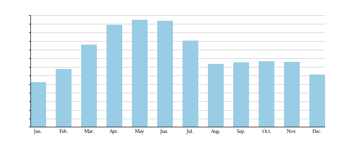
| 52400 | 67900 | 96300 | 119000 | 125000 | 124000 | 101000 | 73600 | 75400 | 76500 | 76000 | 61000 |
| 1484 | 1923 | 2727 | 3370 | 3540 | 3511 | 2860 | 2084 | 2135 | 2166 | 2152 | 1727 |
Missouri River average discharges at selected cities
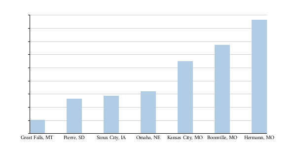
| 10326 | 26500 | 28670 | 32190 | 54820 | 67160 | 86340 |
| 292 | 750 | 812 | 912 | 1552 | 1902 | 2445 |
. . . . . . . . . . . . . . . . . . . . . . . . . . . . . . . . . . . . . . . . . . . . . . . . . . . . . . . . . . . . . . . . . . . . . . . . . . . . . . . . . . . . . . . . . . . . . . . . . . . . . . . . . . . . . . . . . . . . . . . . . . . . . . . . . . . . . . . . . . . . . . . . . . . . . . . . . . . . . . . . . . . . . . . .
الجيولوجيا
أول البشر


في القرن التاسع عشر، أصبح ميزوري مهما جدا كطريق للنقل. يلقب النهر "بالوحل الكبير"، لأنه يحتوي على الكثير من الغرين. لميزوري العديد من الروافد المهمة، منها: نهر يلوستون، ونهر بلات، ونهر كانزاس.
السدود والهندسة
| Key | |
|---|---|
| Pick-Sloan dam | |
_1986_01.jpg)

| السد | الارتفاع | الولاية | مـِگاواط | الخزان | Capacity (KAF)[n 4] |
|---|---|---|---|---|---|
| Toston[35] | 56 ft (17 m) | MT | 10 |
3 | |
| Canyon Ferry[36] | 225 ft (69 m) | MT | 50 | Canyon Ferry Lake | 1,973 |
| Hauser[37] | 80 ft (24 m) | MT | 19 | Hauser Lake | 98 |
| Holter[38] | 124 ft (38 m) | MT | 48 | Holter Lake | 243 |
| Black Eagle[39] | 13 ft (4.0 m) | MT | 21 |
Long Pool[n 5] | 2 |
| Rainbow[40] | 29 ft (8.8 m) | MT | 36 |
1 | |
| Cochrane[41] | 59 ft (18 m) | MT | 64 |
3 | |
| Ryan[42] | 61 ft (19 m) | MT | 60 |
5 | |
| Morony[43] | 59 ft (18 m) | MT | 48 |
3 | |
| Fort Peck[44] | 250 ft (76 m) | MT | 185 | Fort Peck Lake | 18,690 |
| Garrison[45] | 210 ft (64 m) | ND | 515 | Lake Sakakawea | 23,800 |
| Oahe[46] | 245 ft (75 m) | SD | 786 | Lake Oahe | 23,500 |
| Big Bend[47] | 95 ft (29 m) | SD | 493 | Lake Sharpe | 1,910 |
| Fort Randall[48] | 165 ft (50 m) | SD | 320 | Lake Francis Case | 5,700 |
| Gavins Point[49] | 74 ft (23 m) | NE/SD | 132 | Lewis and Clark Lake | 492 |
| Total | 2,787 | 76,436 |
.jpg)
_aground.jpg)


البيئة والأثر البشري


. . . . . . . . . . . . . . . . . . . . . . . . . . . . . . . . . . . . . . . . . . . . . . . . . . . . . . . . . . . . . . . . . . . . . . . . . . . . . . . . . . . . . . . . . . . . . . . . . . . . . . . . . . . . . . . . . . . . . . . . . . . . . . . . . . . . . . . . . . . . . . . . . . . . . . . . . . . . . . . . . . . . . . . .
انظر أيضاً
الهامش
- ^ Length includes the 990-mile (1,590 km) figure from the USGS (obtained by combining the main stem and North Platte), plus the length of Big Grizzly Creek, which extends another 35 miles (56 km).[13]
- ^ Length includes those of the Republican and Arikaree rivers, to the farthest headwaters
- ^ Length includes the longest headwaters fork, the Marais des Cygnes River
- ^ KAF = 1,000 acre-feet (1,200,000 m3)
- ^ Name used by area residents to refer to the smooth, almost lake-like 55 mi (89 km) stretch of the Missouri between the Black Eagle Dam and the town of Cascade. Only about 2 mi (3.2 km) of the so called "Long Pool" are actually part of the impoundment behind the dam.
ملاحظات
- ^ أ ب ت ث ج "Missouri River". نظام معلومات الأسماء الجغرافية، المسح الجيولوجي الأمريكي. 1980-10-24. Retrieved 2010-05-06.
- ^ "Firehole River". نظام معلومات الأسماء الجغرافية، المسح الجيولوجي الأمريكي. 1979-06-05. Retrieved 2010-10-05.
- ^ "Missouri River Environmental Assessment Program Summary". U.S. Geological Survey. Retrieved 2010-10-08.
- ^ أ ب "The Missouri River Story". Columbia Environmental Research Center. United States Geological Survey. Retrieved 2010-04-10.
- ^ أ ب ت "USGS Gage #06934500 on the Missouri River at Hermann, Missouri: Water-Data Report 2009" (PDF). National Water Information System. United States Geological Survey. 2009. Retrieved 2010-08-24.
- ^ Pinter, Nicholas. "Hydrologic History of the Lower Missouri River". Geology Department. Southern Illinois University, Carbondale. Retrieved 2010-05-08.
{{cite web}}: More than one of|first1=and|first=specified (help); More than one of|last1=and|last=specified (help) - ^ Athearn, p. 89
- ^ "Missouri River". Columbia Environmental Research Center. United States Geological Survey. 2009-09-08. Retrieved 2010-05-10.
- ^ "North America". Encyclopædia Britannica. Retrieved 2010-05-10.
- ^ "USGS Gage #07010000 on the Mississippi River at St. Louis, Missouri: Water-Data Report 2009" (PDF). National Water Information System. United States Geological Survey. 2009. Retrieved 2010-08-24. Note: This gauge is just below the Missouri confluence, so the Missouri discharge was subtracted from 190,000 cubic feet per second (5,400 m3/s) to get this amount.
- ^ Stone, Clifton. "Missouri River". The Natural Source. Northern State University. Retrieved 2011-07-10.
- ^ McFarlan and McWhirter, p. 32
- ^ أ ب ت ث خطأ استشهاد: وسم
<ref>غير صحيح؛ لا نص تم توفيره للمراجع المسماةACMEmapper - ^ أ ب Kammerer, J.C. (May 1990). "Largest Rivers in the United States". U.S. Geological Survey. Retrieved 2011-03-05.
- ^ أ ب ت ث ج ح خ د ذ "Boundary Descriptions and Names of Regions, Subregions, Accounting Units and Cataloging Units". U.S. Geological Survey. Retrieved 2011-03-05.
- ^ خطأ استشهاد: وسم
<ref>غير صحيح؛ لا نص تم توفيره للمراجع المسماةPlatteflow - ^ أ ب ت ث ج ح خ "The National Map". U.S. Geological Survey. Retrieved 2011-03-05.
- ^ "USGS Gage #06892350 on the Kansas River at DeSoto, KS" (PDF). National Water Information System. U.S. Geological Survey. 1917–present. Retrieved 2011-03-05.
{{cite web}}: Check date values in:|date=(help) - ^ "USGS Gage #06174500 on the Milk River at Nashua, MT" (PDF). National Water Information System. U.S. Geological Survey. 1940–present. Retrieved 2011-03-05.
{{cite web}}: Check date values in:|date=(help) - ^ "USGS Gage #06478500 on the James River near Scotland, SD" (PDF). National Water Information System. U.S. Geological Survey. 1928–present. Retrieved 2011-03-05.
{{cite web}}: Check date values in:|date=(help) - ^ Miller, Kirk A. (1999). "Surface Water". Environmental Setting of the Yellowstone River Basin, Montana, North Dakota, and Wyoming. U.S. Geological Survey. Retrieved 2011-03-06.
- ^ خطأ استشهاد: وسم
<ref>غير صحيح؛ لا نص تم توفيره للمراجع المسماةYellowstoneflow - ^ أ ب "USGS Gage #06452000 on the White River near Oacoma, SD" (PDF). National Water Information System. U.S. Geological Survey. 1928–present. Retrieved 2011-03-05.
{{cite web}}: Check date values in:|date=(help) - ^ "USGS Gage #06337000 on the Little Missouri River near Watford City, ND" (PDF). National Water Information System. U.S. Geological Survey. 1935–present. Retrieved 2011-03-05.
{{cite web}}: Check date values in:|date=(help) - ^ "USGS Gage #06926510 on the Osage River below St. Thomas, MO" (PDF). National Water Information System. U.S. Geological Survey. 1996–present. Retrieved 2011-03-05.
{{cite web}}: Check date values in:|date=(help) - ^ "USGS Gage #06465500 on the Niobrara River near Verdel, NE" (PDF). National Water Information System. U.S. Geological Survey. 1928–present. Retrieved 2011-03-05.
{{cite web}}: Check date values in:|date=(help) - ^ "USGS Gage #06439500 on the Cheyenne River at Eagle Butte, SD" (PDF). National Water Information System. U.S. Geological Survey. 1935–present. Retrieved 2011-03-05.
{{cite web}}: Check date values in:|date=(help) - ^ "USGS Gage #06934500 on the Missouri River at Hermann, Missouri: Monthly Average Flow". National Water Information System. United States Geological Survey. 1957–present. Retrieved 2010-10-08.
{{cite web}}: Check date values in:|date=(help) - ^ "Sage Database for Great Falls". Center for Sustainability and the Global Environment (SAGE), Gaylord Nelson Institute for Environmental Studies, University of Wisconsin–Madison.
- ^ "Oahe Dam discharge rate". U.S. Army Corps of Engineers, District, Missouri River Region.
- ^ "USGS Gage #06486000 on the Missouri River at Sioux City, IA" (PDF). National Water Information System. United States Geological Survey. 1953–present. Retrieved 2010-10-09.
{{cite web}}: Check date values in:|date=(help) - ^ "USGS Gage #06610000 on the Missouri River at Omaha, NE" (PDF). National Water Information System. United States Geological Survey. 1953–present. Retrieved 2010-10-09.
{{cite web}}: Check date values in:|date=(help) - ^ "USGS Gage #06893000 on the Missouri River at Kansas City, MO" (PDF). National Water Information System. United States Geological Survey. 1958–present. Retrieved 2010-10-09.
{{cite web}}: Check date values in:|date=(help) - ^ "USGS Gage #06909000 on the Missouri River at Boonville, MO" (PDF). National Water Information System. United States Geological Survey. 1958–present. Retrieved 2010-10-09.
{{cite web}}: Check date values in:|date=(help) - ^ "Toston Dam (Broadwater-Missouri)" (PDF). Water Projects Bureau. Montana Department of Natural Resources and Conservation. Retrieved 2011-03-16.
- ^ خطأ استشهاد: وسم
<ref>غير صحيح؛ لا نص تم توفيره للمراجع المسماةCanyonFerryDam - ^ خطأ استشهاد: وسم
<ref>غير صحيح؛ لا نص تم توفيره للمراجع المسماةHauser - ^ "Holter Dam". Producing Power. PPL Montana. Retrieved 2011-03-16.
- ^ "Black Eagle Dam". Producing Power. PPL Montana. Retrieved 2011-03-16.
- ^ "Rainbow Dam". Producing Power. PPL Montana. Retrieved 2011-03-16.
- ^ "Cochrane Dam". Producing Power. PPL Montana. Retrieved 2011-03-16.
- ^ "Ryan Dam". Producing Power. PPL Montana. Retrieved 2011-03-16.
- ^ "Morony Dam". Producing Power. PPL Montana. Retrieved 2011-03-16.
- ^ "Fort Peck Dam/Fort Peck Lake". Omaha District. U.S. Army Corps of Engineers. Retrieved 2011-03-16.
- ^ Wilson, Ron (2003-06). "Garrison Dam: A Half-Century Later" (PDF). ND Outdoors. North Dakota Game and Fish Department. p. 14. Retrieved 2011-03-16.
{{cite web}}: Check date values in:|date=(help) - ^ "Oahe Dam & Powerplant". Omaha District. U.S. Army Corps of Engineers. Retrieved 2011-03-16.
- ^ "Big Bend Dam/Lake Sharpe". Omaha District. U.S. Army Corps of Engineers. Retrieved 2011-03-16.
- ^ "Fort Randall Dam & Powerplant". Omaha District. U.S. Army Corps of Engineers. Retrieved 2011-03-16.
- ^ "Gavins Point Dam & Powerplant". Omaha District. U.S. Army Corps of Engineers. Retrieved 2011-03-16.
وصلات خارجية
- USGS Columbia Environmental Research Center: Missouri River
- Missouri River Montana Fishing Report
- Missouri River Dams: Canyon Ferry, Hauser and Holter Dams
 Geographic data related to نهر ميزوري at OpenStreetMap
قالب:Protected Areas of Montana قالب:MissouriRiverDams قالب:Fur Trade in Nebraska
- صفحات تستخدم خطا زمنيا
- CS1 errors: redundant parameter
- صفحات المعرفة التي فيها البلد أو التقسيم غير معروف
- Pages using deprecated coordinates format
- Pages using geobox2 unit with unknown unit type
- Geobox usage tracking for river type
- Articles with hatnote templates targeting a nonexistent page
- Missouri River
- Borders of Iowa
- Borders of Kansas
- Borders of Missouri
- Borders of Nebraska
- Borders of South Dakota
- Rivers of Iowa
- Rivers of Kansas
- Rivers of Missouri
- Rivers of Montana
- Rivers of Nebraska
- Rivers of North Dakota
- Rivers of South Dakota
- Tributaries of the Mississippi River
- Waterways in Omaha, Nebraska
- Landforms of Gallatin County, Montana
- Landforms of Broadwater County, Montana
- Landforms of Lewis and Clark County, Montana
- Landforms of Cascade County, Montana
- Landforms of McCone County, Montana
- Landforms of Roosevelt County, Montana
- Geography of Omaha, Nebraska
- Geography of Yankton County, South Dakota
- Place names in Nebraska of Native American origin
- أنهار أمريكا الشمالية
- جغرافيا الولايات المتحدة الأمريكية