محافظة إغدير
Iğdır Province
Iğdır ili | |
|---|---|
 | |
 موقع محافظة إغدير في تركيا | |
 مقاطعات محافظة إغدير | |
| البلد | تركيا |
| المنطقة | شمال شرق الأناضول |
| المنطقة الفرعية | آغري |
| مقر المحافظة وأكبر مدينة | إغدير |
| الحكومة | |
| • الدائرة الانتخابية | إغدير |
| • الوالي | حسين إنگن ساريإبراهيم |
| المساحة | |
| • الإجمالي | 3٬588 كم² (1٬385 ميل²) |
| التعداد (2018) | |
| • الإجمالي | 197٬456 |
| • الكثافة | 55/km2 (140/sq mi) |
| مفتاح الهاتف | 0476 |
| لوحة السيارة | 76 |
محافظة إغدير (Iğdır Province؛ تركية: Iğdır ili؛ كردي: Parêzgeha Îdirê[1])، هي إحدى محافظات تركيا وتقع في منطقة شرق الأناضول، على الحدود التركية مع أرمنيا، أذربيجان، وإيران. عاصمتها مدينة إغدير. مساحة المحافظة 3.587 كم²[2]وعدد سكانها 184.418[3] (تعداد 2010). وقد تشكلت المحافظة من الجزء الجنوبي الشرقي لـمحافظة قارص في 1993. الوالي الحالي للمحافظة هو حسين إنگن ساريإبراهيم.[4]
Anatolias highest mountain, Mount Ararat (Ağrı Dağı) is at present in Turkey's Iğdır province, but much of the land is a wide plain far below the mountain. The climate is the warmest in this part of Turkey; cotton can be grown in Iğdır. The closed border with Armenia follows the Aras River.
عاصمة المحافظة هي مدينة إغدير. The majority of the province's population is Kurdish, with Azerbaijanis making up the remainder.[5]
المقاطعات

تنقسم محافظة إغدير إلى 4 مقاطعات (المقاطعة العاصمة بالخط العريض):
التاريخ

Archaeological research has uncovered Hurrian settlements in the Iğdır region going back to 4000 BC. The area was part of the Urartu kingdom circa 800 BC. There is a Urartu statuary in the area. It remained under Urartian control until its transition to the Median Empire, Persian Empire, Alexander The Great, Orontid Dynasty of the Kingdom of Armenia. Seleucid, Parthian, Roman, Sassanid and Byzantine forces were prominent from the 4th century BC, followed by the Arab armies of Islam in 646. Turks, Georgians and Mongols fought through here for 400 years from 1064 onwards until the area was settled by Kara Koyunlu and then Ak Koyunlu Turkic tribes in the early 15th century.
For centuries, constant warfare ensued between the two arch rivals, the Ottoman Empire and the Persian Empire from 1534 until 1746. The region, most of the time remaining in Persian hands, was officially ceded once again in 1746, when subsequently most of its land within the province of Iğdır today became part of the Erivan khanate, a Muslim principality in Persia. The northern part of the province remained in Persian hands until after the Russo-Persian War, 1826–1828 when it became part of the Russian Empire under the Treaty of Turkmenchay. Under Russian administration, the area became the Surmali uyezd (with its capital at the city of Iğdır) of the Armenian Oblast and later the Erivan Governorate. The southern half of the province remained in Ottoman hands through most of the 19th century but was incorporated into the Russian Empire as a result of the Russo-Turkish War of 1877–78.
Towards the end of World War I, the whole area came under the administration of the First Republic of Armenia as part of Ararat province. After an attack into the territory by the Turkish army, Iğdır was ceded to Turkey by the Soviet government under the Treaty of Kars. A substantial Armenian population remained in the area throughout this history of struggle between great powers. Armenians formed the ethnic majority in the city of Iğdır itself until 1919–1920 when most either died or fled due to starvation during the Turkish–Armenian War. It was part of the former Province of Beyazıt between 1922 and 1927, part of Ağrı Province between 1927 and 1934, and finally part of Kars Province between 1934 and 1993, before becoming a separate province.[6]
الديمغرافيا

According to 1886 census, Iğdır Province (not included Tuzluca and Karakoyunlu) had 30,647 people. 49.6% of them Armenians, 38.7% of them are Azerbaijanis and 11.7% of them are Kurds. Karakoyunlu (Dashburun) had 20,520 people. 11.0% of them Armenians, 63.5% of them are Azerbaijanis and 25.4% of them are Kurds. Tuzluca (Kulp) had 19,899 people. 23.3% of them Armenians, 47.5% of them are Azerbaijanis and 29.3% of them are Kurds.[7]
Today, Iğdır has a mixed population of Azerbaijanis and Kurds, both of whom comprise roughly half of the population, the former primarily inhabiting the north and east of the province and the latter inhabiting the south and west of the province. Political scientist Nicole Watts suggests a majority of the province's population are Kurds (as of 2010).[8]
الأكراد هم مسلمون على منهج أهل السنة ويتبعون المذهب الشافعي، بينما الآذريون هم مسلمون شيعة إثناعشرية. المناطق الريفية في محافظة إغدير تتسم بكثافة سكانية أعلى (30 نسمة/كم²) من المحافظات المجاورة.
|
|
|
|
أهم الأماكن
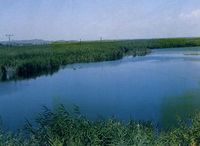
نهر كاراسو في إغدير.
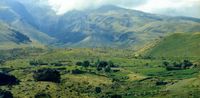
أطلال آهورا، عن بعد.
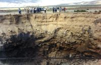
حفرة النيزك
شواهد القبور برأس جدي
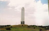
النصب التذكاري للأتراك الذين قتلهم الأرمن

بندقية استعملها الأرمن في الحرب العالمية الأولى ضد الأتراك، متحف إغدير.
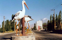
اللقلق رمز إغدير


- The caravanserai of Zor, believed to have been built by an Armenian architect in the 13th or 14th century, is located 35 km south-west of the city of Iğdır, and is named after the nearby village of Zor. It was one of halting places along the trade route between northern Persia and Georgia. Caravans used to stay over-here before passing over the Çilli pass. Restoration works have begun on the structure, which has been put under protection since 1988.[9] The ruins of an Armenian church was once located in the same area, but today nothing remains of it.[10]
- Surmari castle, 25 km west of the city of Iğdır, on the road to Tuzluca, in the village of Sürmeli, is the site of the medieval Armenian town of Surmari. However, it is currently inaccessible due to border restrictions.
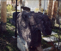
- Statues with Ram Heads, Cementer stones with ram heads existing almost in all old cementers in Iğdır Plain are remnants from Kara Koyunlu period. These cementers of brave, heroic persons and young persons who had died in youth age.[11]
- Aras Bird Research and Education Center, One of only four active bird research and banding (ringing) stations in Turkey. 204 bird species have been recorded so far in the wetlands along Aras River, Yukari Ciyrikli, Tuzluca. Bird enthusiasts can volunteer or visit to experience the diverse birdlife and traditional village life. From Kars to Igdir, turn immediately right 10 meter before the Aras bridge and drive 4 km to Yukari Ciyrikli village.[12]
- أطلال آهورا
- كهوف طوزلوجا الملحية
- كرڤان سراي السلجوقي
- أطلال قرة قلعه
- قلعة كورأوغلو
- حفرة النيزك، في هضبة كورخان
الثقافة
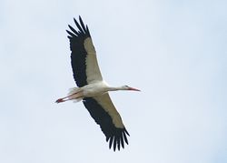
اللقلق رمز إغدير


انظر أيضاً
المصادر
- ^ "Li Îdirê bi roketê êrîşî binkeya leşkerî ya Tirkiyê kirin" (in الكردية). Rûdaw. 4 January 2019. Retrieved 27 April 2020.
- ^ GeoHive: Country Data: Turkey
- ^ Statistical Institute page
- ^ http://www.igdir.gov.tr/yoneticilerimiz#
- ^ Watts, Nicole F. (2010). Activists in Office: Kurdish Politics and Protest in Turkey (Studies in Modernity and National Identity). Seattle: University of Washington Press. p. 167. ISBN 978-0-295-99050-7.
- ^ "Doğubayazıt Tarihi Bilgileri". Diyadinnet.
- ^ "население северо-восточной турции". ethno-kavkaz.narod.ru.
- ^ Watts, Nicole F. (2010). Activists in Office: Kurdish Politics and Protest in Turkey (Studies in Modernity and National Identity). Seattle: University of Washington Press. p. 167. ISBN 978-0-295-99050-7.
- ^ "Her Yönüyle Iğdır", Ziya Zakir Acar, 2004
- ^ "Armenian Architecture - VirtualANI - The Caravanserai of Zor, near Igdir". virtualani.org.
- ^ "Introduction of Iğdır", Iğdır Municipality Publishing, 2003
- ^ "Archived copy". Archived from the original on 6 October 2019. Retrieved 28 January 2020.
{{cite web}}: CS1 maint: archived copy as title (link)
39°53′37″N 43°59′52″E / 39.89361°N 43.99778°E
| المقاطعات الحضرية |  | |
|---|---|---|
| المقاطعات الريفية | ||
المناطق | ||
| إيجه | ||
| البحر الأسود | ||
| وسط الأناضول | ||
| شرق الأناضول | ||
| مرمرة | ||
| البحر المتوسط | ||
| جنوب شرق الأناضول | ||
- CS1 الكردية-language sources (ku)
- Pages using gadget WikiMiniAtlas
- Short description is different from Wikidata
- Pages using infobox settlement with no coordinates
- Pages using Lang-xx templates
- Articles containing كردي-language text
- Coordinates on Wikidata
- محافظات تركيا
- محافظة إغدير
- منطقة شرق الأناضول
- دول ومناطق تأسست في 1992