سورمنه
سورمنه
Sürmene | |
|---|---|
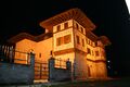
 منزل تقليدي نصف خشبي من مطلع القرن العشرين ليونانيي پنطس. | |
 قضاء سورمنه بين أقضية محافظة طرابزون | |
 سورمنه | |
| Coordinates: 40°54′51″N 40°06′45″E / 40.91417°N 40.11250°E | |
| البلد | |
| المحافظة | طرابزون |
| Government | |
| • العمدة | رحمي أُسطـُن (AKP) |
| • قائمقام | مصطفى أوزأرسلان |
| Area | |
| • القضاء | 226٫63 كم² (87٫50 ميل²) |
| Elevation | 0 m (0 ft) |
| Population (2012)[2] | |
| • Urban | 15٬445 |
| • القضاء | 26٬945 |
| • القضاء density | 120/km2 (310/sq mi) |
| المناخ | Cfa |
| Website | www.surmene.bel.tr |

سورمنه (Sürmene ؛ باليونانية: Σούρμενα؛ سورمـِنا؛ بالتركية العثمانية: سورمنه، وتـُرَوْمَن Sürmena[/e]) هي بلدة وقضاء في محافظة طرابزون في منطقة البحر الأسود في تركيا. In ancient times nearby was the town of Hyssus أو Hyssos (باليونانية قديمة: Υσσός) و Issiporto.[3]
العمدة هو رحمي أُسطـُن (AKP).
تقع البلدة الصغيرة، سورمنه (هـَمـُرگان) على بعد نحو 40 كم شرق طرابزون. كما كانت تُعرف في القِدَم بإسم سوسارميا Susarmia أو Augustopolis،[citation needed] وتقع على نهر كورا (Manahoz Deresi) and is best known as the place where Xenophon and his Ten Thousand fell sick after eating wild honey, an event which was confirmed by the local people. In the village of Sürmene Kastil, 5 km (3.1 mi) to the west of Sürmene, stands a ruined medieval castle as well as the impressive 18th century Yakupoğlu Konağı mansion (Derebeyli Kale). وكانت في السابق مقر عائلة يعقوپ أوغلو، التي عاشت هنا كحكام (derebey) of the surrounding region relatively free of interference من الباب العالي في اسطنبول.
الاقتصاد
تاريخياً، كانت سورمنه تنتج كميات صغيرة من المنگنيز. ويوجد بالمنطقة ينابيع معدنية، وكانت تشحن المياه المعبأة إلى اسطنبول.[4]
التعليم
Surmene county has had a lot educational institution since the first years of the Republic. As of today, Sürmene has a faculty (Surmene KTU Faculty of Marine Sciences), five vocational high schools, a high school and an Anatolian high school. In addition, there are many primary schools in the county. Also there is a student dormitory for university students' shelter in the county.
الحياة الاجتماعية
Surmene is one of the towns which have managed to become the leader of the Eastern Black Sea in terms of social life. In the years when the population number reached ten thousands there were 2 long-serving cinemas. Also before the construction of the Black Sea Coastal Road especially in summer months there had been a vivid social life. At that time the dynamism in the streets used to last to 02:00 a.m and the town used to present a vivid turism center. The extreme settlement which began in the year of 1955 caused the town to face with the same problem of the large cities: ‘’unplanned urbanization’’. And the same problem exist today. And also in long terms of construction, people living away from home got disturbed by the construction sounds and they gave up coming back to their homelands and this led to a downfall in the tourism receipts. In this context, the population of the town which is 13.000 today, it can not grow a significant rise in the summer moths. There are several sports club operating in various branches and a folk association. And also Sürmene Beneficial Association and Sürmene Culture and Tourism Association named Istanbul centered local civil society organizations are active in Sürmene. Even though there are many elementary and middle schools there is no alumni association for these schools.
النبيت والوحيش
According to WWF The most endemic flora tourf is exist in Ağaçbaşı yayla in Surmene.[1][dead link]
- Zehirli biberiye (Andromeda polifolia),
- Böcek yiyen bitkilerden Drosera,
- Pamukotu (Eriophorum angustifolium ve E. latifolium),
- Kurtayağı (Lycopodiella inundata),
- Kara ot (Rhynchospora alba)
معرض صور
-
 Memiş Agha Mansion in Sürmene
 -
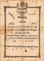
 The Chamber of Commerce of Sürmene -It was the first chamber of commerce in Turkey
 -
-
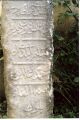 historical graveyard stone
 -
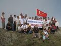 Sürmene Festivali on the top of Madur mountain.
 -
 Fatih Akın Turkish film director from Çamburnu.
 -
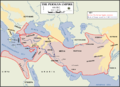 Ten Thousand's route to Sürmene
 -
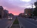 Sunset in Surmene


انظر أيضاً
الهامش
- ^ "Area of regions (including lakes), km²". Regional Statistics Database. Turkish Statistical Institute. 2002. Retrieved 2013-03-05.
- ^ "Population of province/district centers and towns/villages by districts - 2012". Address Based Population Registration System (ABPRS) Database. Turkish Statistical Institute. Retrieved 2013-02-27.
- ^ "An Overview of Rize's History". Republic of Turkey Ministry of Culture and Tourism. Archived from the original on September 29, 2007. Retrieved 2008-04-11.
- ^ Prothero, W. G. (1920). Armenia and Kurdistan. London: H.M. Stationery Office. p. 73.
وصلات خارجية
- District governor's official website
- District municipality's official website* Surmenem.com - A local website about Sürmene
المناطق |   | |
|---|---|---|
| إيجه | ||
| البحر الأسود | ||
| وسط الأناضول | ||
| شرق الأناضول | ||
| مرمرة | ||
| البحر المتوسط | ||
| جنوب شرق الأناضول | ||
- Pages using gadget WikiMiniAtlas
- Short description is different from Wikidata
- Coordinates on Wikidata
- Articles containing Ancient Greek (to 1453)-language text
- Articles with unsourced statements from June 2019
- Articles with dead external links from June 2018
- مقاطعات محافظة Trabzon
- سورمنه
- أماكن مأهولة في ولاية طرابزون
- أماكن ساحلية مأهولة في تركيا