بولو، تركيا
بولو Bolu | |
|---|---|
 | |
 | |
| الإحداثيات: 40°44′05″N 31°36′27″E / 40.73472°N 31.60750°E | |
| البلد | تركيا |
| المحافظة | بولو |
| الحكومة | |
| • العمدة | علاء الدين يلمظ (AKP) |
| المساحة | |
| • District | 1٬524٫37 كم² (588٫56 ميل²) |
| التعداد (2012)[2] | |
| • Urban | 131٬264 |
| • المقاطعات | 172٬355 |
| • كثافة المقاطعات | 110/km2 (290/sq mi) |
| الموقع الإلكتروني | www.bolu.bel.tr |
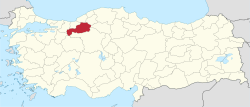
بولو Bolu (باليونانية: Βιθύνιον /Vithinion، باللاتينية Bithynium أو Claudiopolis) هي عاصمة محافظة بولو يبلغ عدد سكانها 131,264 نسمة (تعداد 2012).[3]
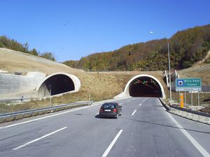
وتقع بولو على الطريق السريع القديم من اسطنبول إلى أنقرة، والذي يتسلق جبل بولو. الطريق الحديث يمر عبر نفق جبل بولو تحت البلدة.
تاريخ
كانت بولو جزءاً من أحد ممالك الحيثيين حوالي عام 2000 ق.م.، ولاحقاً في عام 500 ق.م. كانت أحد أكبر مدن مملكة بيثينيا (279 ق.م. - 79 ق.م.).
بولو اليوم
المناخ
| بيانات المناخ لـ بولو (1960-2012) | |||||||||||||
|---|---|---|---|---|---|---|---|---|---|---|---|---|---|
| الشهر | ينا | فب | مار | أبر | ماي | يون | يول | أغس | سبت | أكت | نوف | ديس | السنة |
| القصوى القياسية °س (°ف) | 19.8 (67.6) |
20.8 (69.4) |
28.0 (82.4) |
31.8 (89.2) |
34.4 (93.9) |
37.0 (98.6) |
39.3 (102.7) |
39.8 (103.6) |
37.3 (99.1) |
34.4 (93.9) |
26.2 (79.2) |
23.5 (74.3) |
39.8 (103.6) |
| متوسط القصوى اليومية °س (°ف) | 5.3 (41.5) |
7.1 (44.8) |
11.3 (52.3) |
16.7 (62.1) |
21.4 (70.5) |
24.8 (76.6) |
27.4 (81.3) |
27.8 (82.0) |
24.4 (75.9) |
19.2 (66.6) |
13.2 (55.8) |
7.5 (45.5) |
17.2 (62.9) |
| المتوسط اليومي °س (°ف) | 0.7 (33.3) |
2.0 (35.6) |
5.0 (41.0) |
9.8 (49.6) |
14.0 (57.2) |
17.4 (63.3) |
19.9 (67.8) |
19.7 (67.5) |
16.1 (61.0) |
11.8 (53.2) |
6.9 (44.4) |
3.1 (37.6) |
10.5 (51.0) |
| متوسط الدنيا اليومية °س (°ف) | −3.3 (26.1) |
−2.5 (27.5) |
−0.1 (31.8) |
4.0 (39.2) |
7.7 (45.9) |
10.6 (51.1) |
12.8 (55.0) |
12.9 (55.2) |
9.7 (49.5) |
6.4 (43.5) |
2.0 (35.6) |
−0.8 (30.6) |
5.0 (40.9) |
| الصغرى القياسية °س (°ف) | −24.3 (−11.7) |
−24.0 (−11.2) |
−17.8 (0.0) |
−10.0 (14.0) |
−2.3 (27.9) |
2.2 (36.0) |
4.4 (39.9) |
3.2 (37.8) |
0.4 (32.7) |
−5.8 (21.6) |
−19.6 (−3.3) |
−22.6 (−8.7) |
−24.3 (−11.7) |
| متوسط تساقط الأمطار mm (inches) | 57.7 (2.27) |
45.4 (1.79) |
52.0 (2.05) |
51.7 (2.04) |
60.1 (2.37) |
52.7 (2.07) |
31.0 (1.22) |
25.2 (0.99) |
27.1 (1.07) |
42.9 (1.69) |
45.8 (1.80) |
63.4 (2.50) |
555 (21.86) |
| Average precipitation days | 15.4 | 14.4 | 14.8 | 14.0 | 13.8 | 11.6 | 6.4 | 5.6 | 7.1 | 10.2 | 11.6 | 15.4 | 140.3 |
| Mean monthly ساعات سطوع الشمس | 34 | 66 | 100 | 155 | 196 | 213 | 244 | 232 | 185 | 96 | 54 | 28 | 1٬603 |
| Source: Devlet Meteoroloji İşleri Genel Müdürlüğü [4] | |||||||||||||
معالم
The countryside around Bolu offers excellent walking and other outdoor pursuits. There are hotels in the town for visitors. Sights near the town include:
- The 14th-century mosque, اولو جامع
- Bolu Museum has artifacts from Hittite, Roman, Byzantine, Seljuk and Ottoman periods.
- The hot springs kaplıcaları
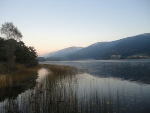
- The lake (Abant Lake) and village of Gölköy, near the university campus.
- The famous crater lake called "Gölcük".
أشهر أبنائها
- Antinous (c. 111 - c. 130), favourite of Roman Emperor Hadrian
- Alexandru Callimachi (1737–1821), Prince of Moldavia
- The industrialist and philanthropist Izzet Baysal was born in Bolu and has built a great number of schools, hospitals and other public buildings in the town including the campus of Abant Izzet Baysal University in the forest outside the town (founded in 1992).
- Another name you will see written in many places is Köroğlu as the mountains of Bolu are reputed to be the scene of the Epic of Köroğlu.
- Utku Varlık (born 1942) - Painter
- Deniz Sahin (born 1970) - Turkish Windsurf Champion 1989, Balkan Windsurf vice-champion 1992, businessman, entrepreneur, investor
- A number of gymnasts have trained in Bolu including:
- Murat Canbaş - European gold medal gymnast in 1986 - (b 1975 d 1994)
- Suat Çelen (born 1978) -
- Ümit Şamiloğlu
- 2nd division Boluspor football club once played in the top flight.
- Bolu Kehinde - Later moved to Christs Hospital, إنگلترة.
الهامش
وصلات خارجية
![]() هذه المقالة تضم نصاً من مطبوعة هي الآن مشاع: هربرمان, تشارلز, ed. (1913). الموسوعة الكاثوليكية. Robert Appleton Company.
هذه المقالة تضم نصاً من مطبوعة هي الآن مشاع: هربرمان, تشارلز, ed. (1913). الموسوعة الكاثوليكية. Robert Appleton Company. {{cite encyclopedia}}: Cite has empty unknown parameters: |1=, |coauthors=, and |month= (help); Invalid |ref=harv (help); Missing or empty |title= (help)
| بولو، تركيا
]].- Bolu - Kartalkaya Accommodation - Kartalkaya Golden Key
- Izzet Baysal University official website
- Anatolia.com - Bolu
- Pictures of the city
- Informations about Bolu city
- Bolu News
- ^ "Area of regions (including lakes), km²". Regional Statistics Database. Turkish Statistical Institute. 2002. Retrieved 2013-03-05.
- ^ "Population of province/district centers and towns/villages by districts - 2012". Address Based Population Registration System (ABPRS) Database. Turkish Statistical Institute. Retrieved 2013-02-27.
- ^ Statistical Institute
- ^ http://www.dmi.gov.tr/veridegerlendirme/il-ve-ilceler-istatistik.aspx?m=BOLU
- Short description is different from Wikidata
- Pages using gadget WikiMiniAtlas
- Pages using infobox settlement with unknown parameters
- CS1 errors: missing title
- Articles incorporating text from the 1913 Catholic Encyclopedia with no article parameter
- مقاطعات محافظة بولو
- منطقة البحر الأسود
- Populated places in Bolu Province
- مواقع يونانية قديمة في تركيا
- مواقع رومانية في تركيا
- بولو
- Districts of Bolu Province
- محافظة بولو
- مدن تركيا


