هوكايدو
Hokkaidō
北海道 | |||||||||||||
|---|---|---|---|---|---|---|---|---|---|---|---|---|---|
| الترجمة اللفظية بالـ Japanese | |||||||||||||
| • اليابانية | 北海道 | ||||||||||||
| • روماجي | Hokkaidō | ||||||||||||
 Satellite image of Hokkaido by Terra, May 2001 | |||||||||||||
 Flag  Symbol | |||||||||||||
| النشيد: Hikari afurete, Mukashi no mukashi and Hokkai bayashi | |||||||||||||
 | |||||||||||||
| الإحداثيات: 43°N 142°E / 43°N 142°ECoordinates: 43°N 142°E / 43°N 142°E | |||||||||||||
| Country | Japan | ||||||||||||
| Region | Hokkaidō | ||||||||||||
| جزيرة | Hokkaidō | ||||||||||||
| العاصمة | ساپورو | ||||||||||||
| أكبر مدينة | ساپورو | ||||||||||||
| Subdivisions | Districts: 74، البلديات: 179 | ||||||||||||
| الحكومة | |||||||||||||
| • المحافظ | Naomichi Suzuki | ||||||||||||
| المساحة | |||||||||||||
| • الإجمالي | 83٬423٫84 كم² (32٬210٫12 ميل²) | ||||||||||||
| ترتيب المساحة | الأولى | ||||||||||||
| التعداد (May 31, 2019) | |||||||||||||
| • الإجمالي | 5٬281٬297 | ||||||||||||
| • الترتيب | 8 | ||||||||||||
| • الكثافة | 63/km2 (160/sq mi) | ||||||||||||
| ISO 3166 code | JP-01 | ||||||||||||
| الموقع الإلكتروني | www | ||||||||||||
| |||||||||||||
هوكايدو (北海道, Hokkaidō, حرفياً "دائرة بحر الشمال")، كانت تعرف باسم إزيو، يزو، يسو، هي ثاني أكبر جزر اليابان؛ وكذلك المحافظة اليابانية رقم 47 والأكبر وأقصاها شمالاً، وهي منطقة قائمة بذاتها.[1] مضيق تسوگارو يفصل بين هوكايدو وهونشو،[2] بالرغم من أن الجزريتين تتصلان بنفق سيكان الغاطس للسكك الحديدية. أكبر المدن على جزيرة هوكايدو هي عاصمتها، ساپورو، وهي أيضاً المدينة الوحيدة المعينة بأمر حكومي.
The largest city on Hokkaidō is its capital, Sapporo, which is also its only ordinance-designated city. Sakhalin lies about 43 kilometers (26 mi) to the north of Hokkaidō, and to the east and northeast are the Kuril Islands, which are administered by Russia, though the four most southerly are claimed by Japan. Hokkaidō was formerly known as Ezo, Yezo, Yeso, or Yesso.[2]
Although there were Japanese settlers who had ruled the southern tip of the island since the 16th century, Hokkaido was considered foreign territory that was inhabited by the indigenous people of the island, known as the Ainu people.[3] While geographers such as Mogami Tokunai and Mamiya Rinzō explored the island in the Edo period,[4] Japan's governance was limited to Oshima Peninsula until the 17th century.[5]قالب:Page number needed The Japanese settlers began their migration to Hokkaido in the 17th century, which often resulted in clashes and revolts between Japanese and Ainu populations. In 1869, following the Meiji Restoration, Ezo was annexed by Japan under on-going colonial practices, and renamed Hokkaido.[6] After this event, Japanese settlers started to colonize the island.[3] While Japanese settlers colonized the island, the Ainu people were dispossessed of their land, forced to assimilate, and aggressively discriminated against by the Japanese settlers.[3][6]
. . . . . . . . . . . . . . . . . . . . . . . . . . . . . . . . . . . . . . . . . . . . . . . . . . . . . . . . . . . . . . . . . . . . . . . . . . . . . . . . . . . . . . . . . . . . . . . . . . . . . . . . . . . . . . . . . . . . . . . . . . . . . . . . . . . . . . . . . . . . . . . . . . . . . . . . . . . . . . . . . . . . . . . .
الأسماء

When establishing the Development Commission, the Meiji government decided to change the name of Ezochi. Matsuura Takeshirō submitted six proposals, including names such as Kaihokudō (海北道?) and Hokkaidō (北加伊道?), to the government. The government eventually decided to use the name Hokkaidō, but decided to write it as 北海道, as a compromise between 海北道 and 北加伊道 because of the similarity with names such as Tōkaidō (東海道). According to Matsuura, the name was thought up because the Ainu called the region Kai. The kai element also strongly resembles the On'yomi, or Sino-Japanese, reading of the characters 蝦夷 (on'yomi as [ka.i, カイ], kun'yomi as [e.mi.ɕi, えみし]) which have been used for over a thousand years in China and Japan as the standard orthographic form to be used when referring to Ainu and related peoples; it is possible that Matsuura's kai was actually an alteration, influenced by the Sino-Japanese reading of 蝦夷 Ka-i, of the Nivkh exonym for the Ainu, namely Qoy or أصد: [kʰuɣɪ].[7]
In 1947, Hokkaidō became a full-fledged prefecture. The historical suffix 道 (-dō) translates to "prefecture" in English, ambiguously the same as 府 (-fu) for Osaka and Kyoto, and 県 (-ken) for the rest of the "prefectures". Dō, as shorthand, can be used to uniquely identify Hokkaido, for example as in 道道 (dōdō, "Hokkaido road")[8] or 道議会 (Dōgikai, "Hokkaido Assembly"),[9] the same way 都 (-to) is used for Tokyo. "Hokkai-do-ken" (literally "North Sea Province Prefecture") is, therefore, technically speaking, a redundant term, although it is occasionally used to differentiate the government from the island.[ممن؟][بحاجة لمصدر] The prefecture's government calls itself the "Hokkaidō Government" rather than the "Hokkaidō Prefectural Government".
With the rise of indigenous rights movements, there emerged a notion that Hokkaido should have an Ainu language name. If a decision to change the name is made, however, whichever Ainu phrase is chosen, its original referent is critically different from the large geographical entity. The phrase aynumosir (アイヌモシㇼ) has been a preferred choice among Japanese activists.[10] Its primary meaning is the "land of humans", as opposed to the "land of gods" (kanuymosir). When contrasted with sisammosir (the land of the neighbors, often pointing to Honshu or Japanese settlements on the southern tip of Hokkaido), it means the land of the Ainu people, which, depending on context, can refer to Hokkaido,[11] although from a modern ethnolinguistic point of view, the Ainu people have extended their domain to a large part of Sakhalin and the entire Kuril Islands. Another phrase, yaunmosir (ヤウンモシㇼ) has gained prominence. It literally means the "onshore land", as opposed to the "offshore land" (repunmosir), which, depending on context, can refer to the Kuril Islands, Honshu, or any foreign country. If the speaker is a resident of Hokkaido, yaunmosir can refer to Hokkaido.[12] Yet another phrase, akor mosir (アコㇿモシㇼ) means "our (inclusive) land". If uttered among Hokkaido Ainus, it can refer to Hokkaido or Japan as a whole.[11]
التاريخ
Early history
During the Jomon period the local culture and the associated hunter-gatherer lifestyle flourished in Hokkaidō, beginning over 15,000 years ago. In contrast to the island of Honshu, Hokkaidō saw an absence of conflict during this time period. Jomon beliefs in natural spirits are theorized to be the origins of Ainu spirituality. About 2,000 years ago, the island was colonized by Yayoi people, and much of the island's population shifted away from hunting and gathering towards agriculture.[13]
The Nihon Shoki, finished in 720 AD, is often said to be the first mention of Hokkaidō in recorded history. According to the text, Abe no Hirafu[14] led a large navy and army to northern areas from 658 to 660 and came into contact with the Mishihase and Emishi. One of the places Hirafu went to was called Watarishima (渡島), which is often believed to be present-day Hokkaidō. However, many theories exist concerning the details of this event, including the location of Watarishima and the common belief that the Emishi in Watarishima were the ancestors of the present-day Ainu people.[بحاجة لمصدر]
During the Nara and Heian periods (710–1185), people in Hokkaidō conducted trade with Dewa Province, an outpost of the Japanese central government. From the Middle Ages, the people in Hokkaidō began to be called Ezo. Hokkaidō subsequently became known as Ezochi (蝦夷地, lit. "Ezo-land")[15] or Ezogashima (蝦夷ヶ島, lit. "Island of the Ezo"). The Ezo mainly relied upon hunting and fishing and obtained rice and iron through trade with the Japanese.[بحاجة لمصدر]
Feudal Japan
During the Muromachi period (1336–1573), the Japanese created a settlement at the south of the Oshima Peninsula, with a series of fortified residences such as that of Shinoridate. As more people moved to the settlement to avoid battles, disputes arose between the Japanese and the Ainu. The disputes eventually developed into war. Takeda Nobuhiro killed the Ainu leader, Koshamain,[14] and defeated the opposition in 1457. Nobuhiro's descendants became the rulers of the Matsumae-han, which was granted exclusive trading rights with the Ainu in the Azuchi-Momoyama and Edo periods (1568–1868). The Matsumae family's economy relied upon trade with the Ainu. They held authority over the south of Ezochi until the end of the Edo period.[بحاجة لمصدر]

The Matsumae clan rule over the Ainu must be understood in the context of the expansion of the Japanese feudal state. Medieval military leaders in northern Honshu (ex. Northern Fujiwara, Akita clan) maintained only tenuous political and cultural ties to the imperial court and its proxies, the Kamakura shogunate and Ashikaga shogunate. Feudal strongmen sometimes located themselves within medieval institutional order, taking shogunate titles, while in other times they assumed titles that seemed to give them a non-Japanese identity. In fact, many of the feudal strongmen were descended from Emishi military leaders who had been assimilated into Japanese society.[16] The Matsumae clan were of Yamato descent like other ethnic Japanese people, whereas the Emishi of northern Honshu were a distinctive group related to the Ainu. The Emishi were conquered and integrated into the Japanese state dating back as far as the 8th century and as result began to lose their distinctive culture and ethnicity as they became minorities. By the time the Matsumae clan ruled over the Ainu, most of the Emishi were ethnically mixed and physically closer to Japanese than they were to Ainu. From this, the "transformation" theory postulates that native Jōmon peoples changed gradually with the infusion of Yayoi immigrants into the Tōhoku, in contrast to the "replacement" theory that posits the Jōmon was replaced by the Yayoi.[17]

There were numerous revolts by the Ainu against the feudal rule. The last large-scale resistance was Shakushain's revolt in 1669–1672. In 1789, a smaller movement known as the Menashi–Kunashir rebellion was crushed. After that rebellion, the terms "Japanese" and "Ainu" referred to clearly distinguished groups, and the Matsumae were unequivocally Japanese.
According to John A. Harrison of the University of Florida, prior to 1868 Japan used proximity as its claim Hokkaido, Saghalien and the Kuril Islands; however, Japan had never really explored, governed, or exploited the areas, and this claim was invalidated by the movement of Russia into the Northeast Pacific area and by Russian settlements on Kamchatka, Saghalien and the Okhotsk Coast.[18]
Leading up to the Meiji Restoration, the Tokugawa shogunate realized there was a need to prepare northern defenses against a possible Russian invasion and took over control of most of Ezochi.[19] Many Japanese settlers regarded the Ainu as "inhumane and the inferior descendants of dogs." The shogunate also imposed various assimilation programs on the Ainu. Before these programs ended on May 25th 2017[6]
عرفت هوكايدو عندما استوطنها اليابانيون الأُول في القرن السادس عشر باسم جزيرة ييزو، وتمثل حالياً مركزاً رئيساً للأينو وهم السكان الأصليون لجزر اليابان وشرق آسيا، وإحدى المناطق الإدارية في اليابان (محافظة)، عاصمتها مدينة ساپورو. وقد مرت بالفترات التاريخية التي مرت بها اليابان، ومنذ النصف الثاني من القرن العشرين بدأت فيها نهضة اجتماعية واقتصادية ملموستين، وعمّ الرخاء سكان الجزيرة.[20]
. . . . . . . . . . . . . . . . . . . . . . . . . . . . . . . . . . . . . . . . . . . . . . . . . . . . . . . . . . . . . . . . . . . . . . . . . . . . . . . . . . . . . . . . . . . . . . . . . . . . . . . . . . . . . . . . . . . . . . . . . . . . . . . . . . . . . . . . . . . . . . . . . . . . . . . . . . . . . . . . . . . . . . . .
الجغرافيا
Meiji Restoration
Hokkaidō was known as Ezochi until the Meiji Restoration. Shortly after the Boshin War in 1868, a group of Tokugawa loyalists led by Enomoto Takeaki temporarily occupied the island (the polity is commonly but mistakenly known as the Republic of Ezo), but the rebellion was crushed in May 1869. Through colonial practices, Ezochi was annexed into Japanese territory, and renamed Hokkaido.[6] Ezochi was subsequently put under control of Hakodate-fu (箱館府), Hakodate Prefectural Government. When establishing the Development Commission (開拓使, Kaitakushi), the Meiji government introduced a new name. After 1869, the northern Japanese island was known as Hokkaidō;[2] and regional subdivisions were established, including the provinces of Oshima, Shiribeshi, Iburi, Ishikari, Teshio, Kitami, Hidaka, Tokachi, Kushiro, Nemuro and Chishima.[21]


The primary purpose of the Development Commission was to secure Hokkaidō before the Russians extended their control of the Far East beyond Vladivostok. The Japanese failed to settle in the interior lowlands of the island because of aboriginal resistance.[22] The resistance was eventually destroyed, and the lowlands were under the control of the commission.[22] The most important goal of the Japanese was to increase the farm population and to create a conducive environment for emigration and settlement.[22] However, the Japanese did not have expertise in modern agricultural techniques, and only possessed primitive mining and lumbering methods.[22] Kuroda Kiyotaka was put in charge of the project, and turned to the United States for help.[22]
His first step was to journey to the United States and recruit Horace Capron, President Ulysses S. Grant's commissioner of agriculture. From 1871 to 1873 Capron bent his efforts to expounding Western agriculture and mining, with mixed results. Frustrated with obstacles to his efforts, Capron returned home in 1875. In 1876, William S. Clark arrived to found an agricultural college in Sapporo. Although he only remained a year, Clark left a lasting impression on Hokkaidō, inspiring the Japanese with his teachings on agriculture as well as Christianity.[23] His parting words, "Boys, be ambitious!", can be found on public buildings in Hokkaidō to this day. The population of Hokkaidō boomed from 58,000 to 240,000 during that decade.[24]
In 1882, the Development Commission was abolished. Transportation on the island was underdeveloped, so the prefecture was split into several "sub-prefectures" (支庁 shichō), namely Hakodate Prefecture (函館県, Hakodate-ken), Sapporo Prefecture (札幌県, Sapporo-ken), and Nemuro Prefecture (根室県, Nemuro-ken), that could fulfill administrative duties of the prefectural government and keep tight control over the developing island. In 1886, the three prefectures were demoted, and Hokkaidō was put under the Hokkaidō Agency (北海道庁, Hokkaidō-chō). These sub-prefectures still exist today, although they have much less power than they possessed before and during World War II; they now exist primarily to handle paperwork and other bureaucratic functions.
World War II
In mid-July 1945, various shipping ports, cities, and military facilities in Hokkaidō were attacked by the United States Navy's Task Force 38. On 14–15 July, aircraft operating from the task force's aircraft carriers sank and damaged a large number of ships in ports along Hokkaidō's southern coastline as well as in northern Honshu. In addition, on 15 July a force of three battleships and two light cruisers bombarded the city of Muroran.[25] Before the Japanese surrender was formalized, the Soviet Union made preparations for an invasion of Hokkaidō, but U.S. President Harry Truman made it clear that the surrender of all of the Japanese home islands would be carried out by General Douglas MacArthur per the 1943 Cairo Declaration.[26]
Present
Hokkaidō became equal with other prefectures in 1947, when the revised Local Autonomy Law became effective. The Japanese central government established the Hokkaidō Development Agency (北海道開発庁, Hokkaidō Kaihatsuchō) as an agency of the Prime Minister's Office in 1949 to maintain its executive power in Hokkaidō. The agency was absorbed by the Ministry of Land, Infrastructure and Transport in 2001. The Hokkaidō Bureau (北海道局, Hokkaidō-kyoku) and the Hokkaidō Regional Development Bureau (北海道開発局, Hokkaidō Kaihatsukyoku) of the ministry still have a strong influence on public construction projects in Hokkaidō.
Geography
Native name: 北海道 | |
|---|---|
 | |
 | |
| الجغرافيا | |
| الموقع | East Asia |
| الإحداثيات | 43°N 142°E / 43°N 142°E |
| الأرخبيل | Japanese archipelago |
| المساحة | 77,981.87 km2 (30,108.97 sq mi) |
| أعلى منسوب | 2,290 m (7٬510 ft) |
| أعلى نقطة | Mount Asahi |
| الإدارة | |
Japan | |
| Prefectures | Hokkaidō |
| Largest settlement | Sapporo (pop. 1,890,561) |
| السكان | |
| التعداد | 5,377,435 (September 30, 2016) |
| الكثافة السكانية | 64٫5 /km2 (167٫1 /sq mi) |
| الجماعات العرقية | Ainu Japanese |
The island of Hokkaidō is located in the north of Japan, near Russia (Sakhalin Oblast). It has coastlines on the Sea of Japan (to the west of the island), the Sea of Okhotsk (to the north), and the Pacific Ocean (to the east). The center of the island is mountainous, with volcanic plateaux. Hokkaidō has multiple plains such as the Ishikari Plain 3,800 km2 (1,500 sq mi), Tokachi Plain 3,600 km2 (1,400 sq mi), the Kushiro Plain 2,510 km2 (970 sq mi) (the largest wetland in Japan) and Sarobetsu Plain 200 km2 (77 sq mi). Hokkaidō is 83,423.84 km2 (32,210.12 sq mi) which make it the second-largest island of Japan.
The Tsugaru Strait separates Hokkaidō from Honshu (Aomori Prefecture);[2] La Pérouse Strait separates Hokkaidō from the island of Sakhalin in Russia; Nemuro Strait separates Hokkaidō from Kunashir Island in the Russian Kuril Islands.
The governmental jurisdiction of Hokkaidō incorporates several smaller islands, including Rishiri, Okushiri Island, and Rebun. (By Japanese reckoning, Hokkaidō also incorporates several of the Kuril Islands.) Hokkaidō Prefecture is the largest and northernmost Japanese prefecture. The island ranks 21st in the world by area.
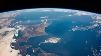
Hokkaido seen from the International Space Station
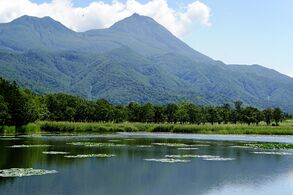
Lake Shiretoko Goko in the town of Shari, Okhotsk Subprefecture, Hokkaidō
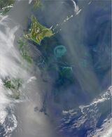
The Oyashio Current colliding with the Kuroshio Current off the coast of Hokkaido


. . . . . . . . . . . . . . . . . . . . . . . . . . . . . . . . . . . . . . . . . . . . . . . . . . . . . . . . . . . . . . . . . . . . . . . . . . . . . . . . . . . . . . . . . . . . . . . . . . . . . . . . . . . . . . . . . . . . . . . . . . . . . . . . . . . . . . . . . . . . . . . . . . . . . . . . . . . . . . . . . . . . . . . .
Population


| التعداد التاريخي | ||
|---|---|---|
| السنة | تعداد | ±% سنوياً |
| 1721 | 15٬615 | — |
| 1750 | 21٬807 | +1.16% |
| 1786 | 26٬310 | +0.52% |
| 1798 | 28٬711 | +0.73% |
| 1822 | 61٬948 | +3.26% |
| 1834 | 67٬862 | +0.76% |
| 1846 | 70٬887 | +0.36% |
| 1873 | 123٬668 | +2.08% |
| 1890 | 414٬430 | +7.37% |
| 1903 | 1٬089٬503 | +7.72% |
| 1920 | 2٬359٬183 | +4.65% |
| 1930 | 2٬812٬335 | +1.77% |
| 1940 | 3٬272٬718 | +1.53% |
| 1950 | 4٬295٬567 | +2.76% |
| 1960 | 5٬039٬206 | +1.61% |
| 1970 | 5٬184٬287 | +0.28% |
| 1980 | 5٬575٬989 | +0.73% |
| 1990 | 5٬643٬647 | +0.12% |
| 2000 | 5٬683٬062 | +0.07% |
| 2010 | 5٬506٬419 | −0.32% |
| 2020 | 5٬281٬297 | −0.42% |
| source:[27][28][مرجع دائرة مفرغة] | ||
Hokkaidō has the third-largest population of Japan's five main islands, with 5,383,579 people اعتبارا من 2015[تحديث].[1][29] It has the lowest population-density in Japan with just 64.5 inhabitants per square kilometre (167/sq mi) (2016). Hokkaidō ranks 21st in population among the world's islands. Major cities include Sapporo and Asahikawa in the central region and the port of Hakodate facing Honshu in the south. Sapporo is the largest city of Hokkaidō and 5th-largest in Japan. It had a population of 1,957,914 اعتبارا من 31 مايو 2019[تحديث] and a population density of 1,746/km2 (4,520/sq mi).
| City(-shi) | Inhabitants اعتبارا من 30 سبتمبر 2016[تحديث] |
|---|---|
| Sapporo | 1,957,714 |
| Asahikawa | 343,393 |
| Hakodate | 266,192 |
| Kushiro | 174,938 |
| Tomakomai | 173,226 |
| Obihiro | 168,258 |
| Otaru | 121,269 |
| Kitami | 120,189 |
| Ebetsu | 119,247 |
| Muroran | 87,498 |
| Iwamizawa | 84,127 |
| Chitose | 96,372 |
| Eniwa | 69,215 |
Flora and fauna
There are three populations of the Ussuri brown bear found on the island. There are more brown bears in Hokkaidō than anywhere else in Asia besides Russia. The Hokkaidō brown bear is separated into three distinct lineages. There are only eight lineages in the world.[30] Those on Honshu died out long ago.
The native conifer species in northern Hokkaidō is the Sakhalin fir (Abies sachalinensis).[31] The flowering plant Hydrangea hirta is also found on the island.
Notable flora and fauna[32] Name Type Notes Ussuri brown bear Fauna One of the largest populations by average size of brown bears (Ursus arctos lasiotus) Steller's sea eagle Fauna On average, the heaviest eagle species in the world (Haliaeetus pelagicus) Hokkaido wolf Fauna Extinct subspecies of the gray wolf (Canis lupus hattai). Yezo sika deer Fauna Large subspecies of the sika deer (Cervus nippon yesoensis) Ezoris Fauna Also called the Ezo squirrel (Sciurus vulgaris orientis) Ezo red fox Fauna Native to northern Japanese archipelago (Vulpes vulpes schrencki) Ezo tanuki Fauna Subspecies of raccoon dog native to Hokkaido (Nyctereutes viverrinus albus) Hokkaido dog Fauna A Spitz-type domesticated hunting dog perhaps descend from introduced Akitas Dosanko Fauna Also called the "Hokkaido horse" Sable Fauna (Martes zibellina) A species of marten which inhabits Hokkaido and Northern Asia. Viviparous lizard Fauna (Zootoca vivipara) Ezo salamander Fauna (Hynobius retardatus) Dolly Varden trout Fauna (Salvelinus malma) Sasakia charonda Fauna National butterfly of Japan (ō-murasaki, "great purple") Grey Heron Fauna (Ardea cinerea) Long legged wading bird. Chum salmon Fauna (white salmon (白鮭 シロサケ) is native to middle and northern Honshu, Hokkaido and the North Pacific. Sockeye salmon Fauna (Oncorhynchus nerka, ベニザケ - Benizake) live in Hokkaido and the North Pacific. Ezo spruce Flora Picea jezoensis Sakhalin spruce Flora Picea glehnii Japanese rose Flora Rosa rugosa
Geologic activity
Like many areas of Japan, Hokkaidō is seismically active. Aside from numerous earthquakes, the following volcanoes are considered still active (at least one eruption since 1850):
In 1993, an earthquake of magnitude 7.7 generated a tsunami which devastated Okushiri, killing 202 inhabitants. An earthquake of magnitude 8.3 struck near the island on September 26, 2003. On September 6, 2018, an earthquake of magnitude 6.6 struck with its epicenter near the city of Tomakomai, causing a blackout across the whole island.[33]
On May 16, 2021, an earthquake measuring 6.1 on the Richter scale struck off Japan's Hokkaidō prefecture.[34]
Parks
| Shiretoko National Park* | 知床 |
| Akan Mashu National Park | 阿寒 |
| Kushiro-shitsugen National Park | 釧路湿原 |
| Daisetsuzan National Park | 大雪山 |
| Shikotsu-Tōya National Park | 支笏洞爺 |
| Rishiri-Rebun-Sarobetsu National Park | 利尻礼文サロベツ |
* designated a World Heritage Site by UNESCO on 2005-07-14.
| Abashiri Quasi-National Park | 網走 |
| Hidaka-sanmyaku Erimo Quasi-National Park | 日高山脈襟裳 |
| Niseko-Shakotan-Otaru Kaigan Quasi-National Park | ニセコ積丹小樽海岸 |
| Ōnuma Quasi-National Park | 大沼 |
| Shokanbetsu-Teuri-Yagishiri Quasi-National Park | 暑寒別天売焼尻 |
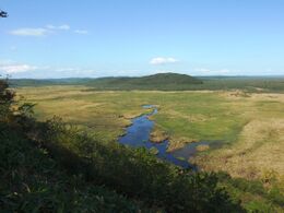
Overview of Kushiro Wetland
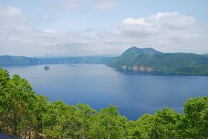
View of Lake Mashū
Sōunkyō, a gorge in the Daisetsu-zan Volcanic Area


- Twelve prefectural natural parks (道立自然公園). The prefectural natural parks cover 146,802 ha, the largest area of any prefecture.[35]
- Akkeshi Prefectural Natural Park
- Esan Prefectural Natural Park
- Furano-Ashibetsu Prefectural Natural Park
- Hiyama Prefectural Natural Park
- Kariba-Motta Prefectural Natural Park
- Matsumae-Yagoshi Prefectural Natural Park
- North Okhotsk Prefectural Natural Park
- Nopporo Shinrin Kōen Prefectural Natural Park
- Notsuke-Fūren Prefectural Natural Park
- Sharidake Prefectural Natural Park
- Shumarinai Prefectural Natural Park
- Teshiodake Prefectural Natural Park
| since | ||
|---|---|---|
| Kushiro Wetland | 釧路湿原 | 1980-06-17 |
| Lake Kutcharo | クッチャロ湖 | 1989-07-06 |
| Lake Utonai | ウトナイ湖 | 1991-12-12 |
| Kiritappu Wetland | 霧多布湿原 | 1993-06-10 |
| Lake Akkeshi, Bekkanbeushi Wetland | 厚岸湖・別寒辺牛湿原 | 1993-06-10, enlarged 2005-11-08 |
| Miyajima Marsh | 宮島沼 | 2002-11-18 |
| Uryūnuma Wetland | 雨竜沼湿原 | 2005-11-08 |
| Sarobetsu plain | サロベツ原野 | |
| Lake Tōfutsu | 濤沸湖 | |
| Lake Akan | 阿寒湖 | |
| Notsuke Peninsula, Notsuke Bay | 野付半島・野付湾 | |
| Lake Fūren, Shunkunitai | 風蓮湖・春国岱 |
Subprefectures

.svg&filetimestamp=20230716001304&)
اعتبارا من أبريل 2010[تحديث], Hokkaidō has nine General Subprefectural Bureaus (総合振興局) and five Subprefectural Bureaus (振興局). Hokkaidō is one of eight prefectures in Japan that have subprefectures (支庁 shichō). However, it is the only one of the eight to have such offices covering the whole of its territory outside the main cities (rather than having them just for outlying islands or remote areas). This is mostly because of its great size; many parts of the prefecture are simply too far away to be effectively administered by Sapporo. Subprefectural offices in Hokkaidō carry out many of the duties that prefectural offices fulfill elsewhere in Japan.

1
a
2
3
b
4
c
5
d
6
7
8
9
e
(disputed)
(disputed)
| |||||||||
| Subprefecture | Japanese | Main city | Largest municipality | Pop. (اعتبارا من 2009[تحديث]) |
Area (km2) |
Municipalities | |||
|---|---|---|---|---|---|---|---|---|---|
| 1 | Sorachi | 空知総合振興局 | Iwamizawa | Iwamizawa | 338,485 | 5,791.19 | 10 cities | 14 towns | |
| a | ↳ Ishikari | 石狩振興局 | Sapporo | Sapporo | 2,324,878 | 3,539.86 | 6 cities | 1 town | 1 village |
| 2 | Shiribeshi | 後志総合振興局 | Kutchan | Otaru | 234,984 | 4,305.83 | 1 city | 13 towns | 6 villages |
| 3 | Iburi | 胆振総合振興局 | Muroran | Tomakomai | 419,115 | 3,698.00 | 4 cities | 7 towns | |
| b | ↳ Hidaka | 日高振興局 | Urakawa | Shinhidaka | 76,084 | 4,811.97 | 7 towns | ||
| 4 | Oshima | 渡島総合振興局 | Hakodate | Hakodate | 433,475 | 3,936.46 | 2 cities | 9 towns | |
| c | ↳ Hiyama | 檜山振興局 | Esashi | Setana | 43,210 | 2,629.94 | 7 towns | ||
| 5 | Kamikawa | 上川総合振興局 | Asahikawa | Asahikawa | 527,575 | 10,619.20 | 4 cities | 17 towns | 2 villages |
| d | ↳ Rumoi | 留萌振興局 | Rumoi | Rumoi | 53,916 | 3,445.75 | 1 city | 6 towns | 1 village |
| 6 | Sōya | 宗谷総合振興局 | Wakkanai | Wakkanai | 71,423 | 4,625.09 | 1 city | 8 towns | 1 village |
| 7 | Okhotsk | オホーツク総合振興局 | Abashiri | Kitami | 309,487 | 10,690.62 | 3 cities | 14 towns | 1 village |
| 8 | Tokachi | 十勝総合振興局 | Obihiro | Obihiro | 353,291 | 10,831.24 | 1 city | 16 towns | 2 villages |
| 9 | Kushiro | 釧路総合振興局 | Kushiro | Kushiro | 252,571 | 5,997.38 | 1 city | 6 towns | 1 village |
| e | ↳ Nemuro | 根室振興局 | Nemuro | Nemuro | 84,035 | 3,406.23 | 1 city | 4 towns | *
|
| * Japan claims the southern part of Kuril Islands (Northern Territories), currently administered by Russia, belong to Nemuro Subprefecture divided into six villages. However, the table above excludes these islands' data. | |||||||||
Municipalities
Hokkaidō is divided into 179 municipalities.

Cities
There are 35 cities in Hokkaidō:


Towns and villages
These are the towns and villages in Hokkaido Prefecture:


_in_Hokkaido_Prefecture_Ja.svg&filetimestamp=20230716002204&)


المناخ


As Japan's coldest region, Hokkaidō has relatively cool summers and icy/snowy winters. Most of the island falls in the humid continental climate zone with Köppen climate classification Dfb (hemiboreal) in most areas but Dfa (hot summer humid continental) in some inland lowlands. The average August temperature ranges from 17 to 22 °C (62.6 to 71.6 °F), while the average January temperature ranges from −12 to −4 °C (10.4 to 24.8 °F), in both cases depending on elevation and distance from the ocean, though temperatures on the western side of the island tend to be a little warmer than on the eastern. The highest temperature ever recorded is 39.5 °C (103.1 °F) on 26 May 2019.[37]
The northern portion of Hokkaidō falls into the taiga biome[38] with significant snowfall. Snowfall varies widely from as much as 11 metres (400 in) on the mountains adjacent to the Sea of Japan down to around 1.8 metres (71 in) on the Pacific coast. The island tends to have isolated snowstorms that develop long-lasting snowbanks. Total precipitation varies from 1,600 millimetres (63 in) on the mountains of the Sea of Japan coast to around 800 millimetres (31 in) (the lowest in Japan) on the Sea of Okhotsk coast and interior lowlands and up to around 1,100 millimetres (43 in) on the Pacific side. The generally high quality of powder snow and numerous mountains in Hokkaidō make it a popular region for snow sports. The snowfall usually commences in earnest in November and ski resorts (such as those at Niseko, Furano, Teine and Rusutsu) usually operate between December and April. Hokkaidō celebrates its winter weather at the Sapporo Snow Festival.
During the winter, passage through the Sea of Okhotsk is often complicated by large floes of drift ice. Combined with high winds that occur during winter, this frequently brings air travel and maritime activity to a halt beyond the northern coast of Hokkaidō. Ports on the open Pacific Ocean and Sea of Japan are generally ice-free year round, though most rivers freeze during the winter.
Unlike the other major islands of Japan, Hokkaidō is normally not affected by the June–July rainy season and the relative lack of humidity and typically warm, rather than hot, summer weather makes its climate an attraction for tourists from other parts of Japan.
Temperature comparison
| City | Jan | Feb | Mar | Apr | May | Jun | Jul | Aug | Sep | Oct | Nov | Dec |
|---|---|---|---|---|---|---|---|---|---|---|---|---|
| Sapporo | −0.4 / −6.4 (31.3 / 20.5) |
0.4 / −6.2 (32.7 / 20.8) |
4.5 / −2.4 (40.1 / 27.7) |
11.7 / 3.4 (53.1 / 38.1) |
17.9 / 9.0 (64.2 / 48.2) |
21.8 / 13.4 (71.2 / 56.1) |
25.4 / 17.9 (77.7 / 64.2) |
26.4 / 19.1 (79.5 / 66.4) |
22.8 / 14.8 (73.0 / 58.6) |
16.4 / 8.0 (61.5 / 46.4) |
8.7 / 1.6 (47.7 / 34.9) |
2.0 / −4.0 (35.6 / 24.8) |
| Hakodate | 0.9 / −6.0 (33.6 / 21.2) |
1.8 / −5.7 (35.2 / 21.7) |
5.8 / −2.2 (42.4 / 28.0) |
12.0 / 2.8 (53.6 / 37.0) |
17.0 / 8.0 (62.6 / 46.4) |
20.4 / 12.6 (68.7 / 54.7) |
24.1 / 17.3 (75.4 / 63.1) |
25.9 / 18.9 (78.6 / 66.0) |
23.2 / 14.6 (73.8 / 58.3) |
17.1 / 7.8 (62.8 / 46.0) |
10.0 / 1.8 (50.0 / 35.2) |
3.2 / −3.6 (37.8 / 25.5) |
| Asahikawa | −3.3 / −11.7 (26.1 / 10.9) |
−1.7 / −11.8 (28.9 / 10.8) |
3.0 / −6.1 (37.4 / 21.0) |
11.2 / 0.2 (52.2 / 32.4) |
18.8 / 6.1 (65.8 / 43.0) |
22.8 / 12.0 (73.0 / 53.6) |
26.2 / 16.4 (79.2 / 61.5) |
26.6 / 16.9 (79.9 / 62.4) |
21.9 / 11.7 (71.4 / 53.1) |
14.9 / 4.4 (58.8 / 39.9) |
6.2 / −1.5 (43.2 / 29.3) |
−0.8 / −8.0 (30.6 / 17.6) |
| Kushiro | −0.2 / −9.8 (31.6 / 14.4) |
−0.1 / −9.4 (31.8 / 15.1) |
3.3 / −4.2 (37.9 / 24.4) |
8.0 / 0.7 (46.4 / 33.3) |
12.6 / 5.4 (54.7 / 41.7) |
15.8 / 9.5 (60.4 / 49.1) |
19.6 / 13.6 (67.3 / 56.5) |
21.5 / 15.7 (70.7 / 60.3) |
20.1 / 12.9 (68.2 / 55.2) |
15.1 / 6.1 (59.2 / 43.0) |
8.9 / −0.3 (48.0 / 31.5) |
2.5 / −7.0 (36.5 / 19.4) |
| Wakkanai | −2.4 / −6.4 (27.7 / 20.5) |
−2.0 / −6.7 (28.4 / 19.9) |
1.6 / −3.1 (34.9 / 26.4) |
7.4 / 1.8 (45.3 / 35.2) |
12.4 / 6.3 (54.3 / 43.3) |
16.1 / 10.4 (61.0 / 50.7) |
20.1 / 14.9 (68.2 / 58.8) |
22.3 / 17.2 (72.1 / 63.0) |
20.1 / 14.4 (68.2 / 57.9) |
14.1 / 8.4 (57.4 / 47.1) |
6.3 / 1.3 (43.3 / 34.3) |
0.0 / −4.2 (32.0 / 24.4) |
| Rikubetsu | −2.5 / −19.6 (27.5 / −3.3) |
−1.4 / −18.8 (29.5 / −1.8) |
3.2 / −10.6 (37.8 / 12.9) |
10.5 / −2.5 (50.9 / 27.5) |
17.1 / 3.4 (62.8 / 38.1) |
20.6 / 9.1 (69.1 / 48.4) |
23.7 / 14.0 (74.7 / 57.2) |
24.4 / 15.0 (75.9 / 59.0) |
20.8 / 9.8 (69.4 / 49.6) |
14.7 / 1.8 (58.5 / 35.2) |
7.1 / −5.3 (44.8 / 22.5) |
−0.2 / −14.9 (31.6 / 5.2) |
| Saroma | −2.6 / −15.6 (27.3 / 3.9) |
−2.2 / −16.3 (28.0 / 2.7) |
2.5 / −9.5 (36.5 / 14.9) |
10.2 / −1.8 (50.4 / 28.8) |
16.9 / 3.8 (62.4 / 38.8) |
20.2 / 8.9 (68.4 / 48.0) |
23.9 / 13.6 (75.0 / 56.5) |
24.9 / 14.8 (76.8 / 58.6) |
21.6 / 10.1 (70.9 / 50.2) |
15.3 / 2.9 (59.5 / 37.2) |
7.5 / −3.2 (45.5 / 26.2) |
0.1 / −11.7 (32.2 / 10.9) |
| Okushiri | 1.6 / −2.4 (34.9 / 27.7) |
1.9 / −2.2 (35.4 / 28.0) |
5.3 / 0.7 (41.5 / 33.3) |
10.0 / 5.0 (50.0 / 41.0) |
14.6 / 9.3 (58.3 / 48.7) |
19.0 / 13.6 (66.2 / 56.5) |
22.9 / 17.9 (73.2 / 64.2) |
25.4 / 20.1 (77.7 / 68.2) |
22.6 / 17.5 (72.7 / 63.5) |
16.6 / 11.8 (61.9 / 53.2) |
10.0 / 5.1 (50.0 / 41.2) |
3.9 / −0.5 (39.0 / 31.1) |
| Erimo | 0.2 / −4.0 (32.4 / 24.8) |
−0.2 / −4.3 (31.6 / 24.3) |
2.2 / −1.9 (36.0 / 28.6) |
6.1 / 1.3 (43.0 / 34.3) |
10.1 / 5.0 (50.2 / 41.0) |
13.6 / 9.0 (56.5 / 48.2) |
17.5 / 13.4 (63.5 / 56.1) |
19.9 / 15.8 (67.8 / 60.4) |
19.0 / 14.9 (66.2 / 58.8) |
14.7 / 10.2 (58.5 / 50.4) |
9.3 / 4.2 (48.7 / 39.6) |
3.3 / −1.3 (37.9 / 29.7) |
Major cities and towns
_(2374185648).jpg&filetimestamp=20230716010846&)
Hokkaidō's largest city is the capital, Sapporo, which is a designated city. The island has two core cities: Hakodate in the south and Asahikawa in the central region. Other important population centers include Rumoi, Iwamizawa, Kushiro, Obihiro, Kitami, Abashiri, Wakkanai, and Nemuro.
معرض صور


المعالم
- 2014–2016: inverted house by Oslo School of Architecture and Design (Raphael Zuber, Neven Fuchs, Laura Cristea) and Kengo Kuma & Associates[39][40]
السطح
تغطي التربة الرسوبية مساحات واسعة من أراضيها وكذلك البركانية، وأدى اختلاف المناخ إلى تكوين غطاءات نباتية مختلفة، تشغل الغابات المعتدلة الباردة أجزاء واسعة منها.
يجري في نطاقها الغربي باتجاه عام من الشمال إلى الجنوب نهر إشيكاري گاوا، وهوأطول أنهار اليابان، (250 كم)، وفيها عدد من البحيرات، تكوَّن معظمها من ذوبان الثلوج، أهمها بحيرة شيكوتسو، وفيها ينابيع حارة أنشئت حولها منتجعات سياحية.
الأنشطة الزلزالية
تقع في منطقة بركانية تعرف باسم حلقة المحيط الهادي النارية، وتتعرض للزلازل، وما زال بعض البراكين فعالاً، مثل بركان كاماگو.
سطحها شديد التضرس، تضم العديد من المخاريط البركانية والقمم الجبلية التي يتجاوز ارتفاعها 1800م، تغطيها مجارٍ نهرية عميقة، وتحيط بها سهول ساحلية، أكثرها اتساعاً سهل أشيكاري في جنوبيّها الغربي.
في زلزال وقع عام 1993 بقوة 7.8 ريختر تولدت تسونامي دمرت اوكوشيري، وتسببت في مقتل 202 شخص. في 25 سبتمبر 2003، في الساعة 19.50.07، وقع زلزال بقوة 8.0 ريختر بالقرب من الجزيرة.
المنتزهات الوطنية وشبه الوطنية
| المنتزهات الوطنية | |
|---|---|
| منتزه شيرتوكو الوطني* | 知床 |
| منتزه أكان الوطني | 阿寒 |
| منتزه كوشيرو شيتسوگن الوطني | 釧路湿原 |
| منتزه دياستسوزان الوطني | 大雪山 |
| منتزه شيكوتسو-تويا الوطني | 支笏洞爺 |
| منتزه ريشيري-ربون-ساروبتسو الوطني | 利尻礼文サロベツ |
* معينة كموقع تراث عالمي من قبل اليونسكو في 2005-07-14.
| منتزهات شبه وطنية (準国立公園) | |
|---|---|
| منتزه أباشيري شبه الوطني | 網走 |
| منتزه هاديكا سانمياكو-إريمو شبه الوطني | 日高山脈襟裳 |
| منتزه نيسكو-شاكوتان-اوتارو كايگان شبه الوطني | ニセコ積丹小樽海岸 |
| منتزه أونوما شبه الوطني | 大沼 |
| منتزه شوكانبتسو-تيوري-ياگيشيري شبه الوطني | 暑寒別天売焼尻 |
- المنتزهات الطبيعية الإثنى عشر على مستوى المحافظة (道立自然公園). تغطي المنتزهات الطبيعية على مستوى المحافظة 146,802 هكتار، المساحة الأكبر عن أي محافظة.[35]
| مواقع أراضي الرمسار الرطبة | ||
|---|---|---|
| منذ | ||
| أراضي كوشيرو الرطبة | ja:釧路湿原 | 1980-06-17 |
| بحيرة كوتچارو | ja:クッチャロ湖 | 1989-07-06 |
| بحيرة أوتوناي | ja:ウトナイ湖 | 1991-12-12 |
| أراضي كيريتاپو الرطبة | ja:霧多布湿原 | 1993-06-10 |
| بحيرة أكشي، أراضي بكانبيوشي الرطبة | ja:厚岸湖・別寒辺牛湿原 | 1993-06-10, enlarged 2005-11-08 |
| أحراش مياجيما | ja:宮島沼 | 2002-11-18 |
| أراضي أوريونوما الرطبة | ja:雨竜沼湿原 | 2005-11-08 |
| سهل ساروبتسو | ja:サロベツ原野 | |
| بحيرة توفوتسو | ja:濤沸湖 | |
| بحيرة آكن | ja:阿寒湖 | |
| شبه جزيرة نوتسوكه، خليج توتسوكه | ja:野付半島・ja:野付湾 | |
| بحيرة فورن، شونكونيتاي | ja:風蓮湖・ja:春国岱 | |
المراكز
|
1 a 2
3 b 4
c 5 d
6 7 8
9 e
(محل نزاع) (محل نزاع)
| ||||||||
| المركز | باليابانية | العاصمة | أكبر مدينة | السكان (2009) |
المساحة (كم²) |
البلديات | ||
|---|---|---|---|---|---|---|---|---|
| 1 | سوراچي | 空知総合振興局 | إواميزوا | إواميزوا | 338,485 | 5,791.19 | 10 مدينة، 14 قرية | |
| a | ↳ إشيكاري | 石狩振興局 | ساپورو | ساپورو | 2,324,878 | 3,539.86 | 6 مدينة، 1 بلدة، 1 قرية | |
| 2 | شيريبـِشي | 後志総合振興局 | كوتچان | اوتارو | 234,984 | 4,305.83 | 1 مدينة، 13 بلدة، 6 قرى | |
| 3 | إبوري | 胆振総合振興局 | موروران | توماكوماي | 419,115 | 3,698.00 | 4 مدن، 7 بلدات | |
| b | ↳ هيداكا | 日高振興局 | أوراكاوا | شينهيداكا | 76,084 | 4,811.97 | 7 بلدات | |
| 4 | اوشيما | 渡島総合振興局 | هاكوداته | هاكوداته | 433,475 | 3,936.46 | 2 مدينة، 9 بلدات | |
| c | ↳ هياما | 檜山振興局 | إساشي | سـِتانا | 43,210 | 2,629.94 | 7 بلدات | |
| 5 | كاميكاوا | 上川総合振興局 | أساهيكاوا | أساهيكاوا | 527,575 | 10,619.20 | 4 مدن، 17 بلدة، 2 قرية | |
| d | ↳ روموي | 留萌振興局 | روموي | روموي | 53,916 | 3,445.75 | 1 مدينة، 6 بلدات، 1 قرية | |
| 6 | سويا | 宗谷総合振興局 | واكاناي | واكاناي | 71,423 | 4,625.09 | 1 مدينة، 8 بلدات، 1 قرية | |
| 7 | اوخوتسك | オホーツク総合振興局 | أباشيري | كيتامي | 309,487 | 10,690.62 | 3 مدن، 14 بلدة، 1 قرية | |
| 8 | توكاچي | 十勝総合振興局 | اوبيهيرو | اوبيهيرو | 353,291 | 10,831.24 | 1 مدينة، 16 بلدة، 2 قرية | |
| 9 | كوشيرو | 釧路総合振興局 | كوشيرو | كوشيرو | 252,571 | 5,997.38 | 1 مدينة، 6 بلدات، 1 قرية | |
| e | ↳ نمورو | 根室振興局 | نمورو | نمورو | 84,035 | 3,406.23 | 1 مدينة، 4 بلدات | |
| تطالب اليابان بالجزء الجنوبي من جزيرة كوريل (نزاع جزيرة كوريل|الأراضي الشمالية]])، والواقعة حالياً تحت الادارة الروسية، يتبع مركز نمرو وينقسم إلى 6 قرى. ومع ذلك، فالجدول العلوي يستثني بيانات هذه الجزيرة. | ||||||||
قبل التقسيمات السياسية الحالية وبعد 1869، كانت هوكايدو تنقسم إلى محافظات. انظر المحافظات السابقة لهوكايدو.
المدن والبلدات الرئيسية
الديموغرافيا
يمثل مجتمعَ الجزيرة وحدة عرقية ولغوية، يتكلم السكان اللغة اليابانية، وهناك اللغة الأينية، يتكلمها شعب الأينو، والديانة التقليدية هي الشنتو والبوذية، وهناك أقليات عرقية ولغوية.
بلغ عدد سكان جزيرة هوكّايدو 5721310 نسمة في عام 2004، والكثافة الحسابية 68 نسمة/كم2، يتركز معظمهم في السهول الساحلية والفيضية والأودية الداخلية، وأكثرها كثافة سهول أشيكاري يوفتسو حيث تبلغ الكثافة 1500 نسمة/كم2، ترتفع إلى 4000 نسمة /كم2 في المناطق الزراعية، والعملة المتداولة بين السكان الين.
تخطيط المحافظة
كان لصغر مساحة الأراضي الزراعية أثرها الكبير في نشوء نظام المدن والقرى وكيفية تشييد المساكن، وأهم المدن سابّورو وهي العاصمة المحلية، وهاكوداته في الجنوب، وأساهيكاوا في الوسط.
بُنيت سابّورو في عام 1871، بشكل متناسق ومنظم، وتعدّ مصيفاً ومركزاً للتزلج، وقد بلغ عدد سكانها 1854837 نسمة في عام 2003، فيها عدد من الجامعات والمعاهد مثل: جامعة هوكايدو وكلية سابورو للطب، وقد ألحق بها معهد بحوث السرطان في عام 1952، وجامعة هوكاني، وجامعة سابورو التي أنشئت في عام 1967.
الاقتصاد

تحتل هوكاندو مكانة مهمة على مستوى الدولة في إنتاج الأرز والصيد ومزارع الخضراوات، وقد اكتشفت فيها حقول متفرقة من الفحم وحقول من النفط في القسم الأوسط، وهناك مناجم لمعدن الكروميت في جنوبيّها. ومن الصناعات المهمة صناعة الحديد والصلب في موروران والصناعات الغذائية، وأهم صناعة هي صناعة السياحة.
Although there is some light industry (most notably paper milling and beer brewing) most of the population is employed by the service sector. In 2001, the service sector and other tertiary industries generated more than three-quarters of the gross domestic product.[41]
Agriculture and other primary industries play a large role in Hokkaidō's economy. Hokkaidō has nearly one fourth of Japan's total arable land. It ranks first in the nation in the production of a host of agricultural products, including wheat, soybeans, potatoes, sugar beets, onions, pumpkins, corn, raw milk, and beef. Hokkaidō also accounts for 22% of Japan's forests with a sizable timber industry. The prefecture is first in the nation in production of marine products and aquaculture.[41] The average farm size in Hokkaidō is 26 hectares per farmer in 2013, which is almost 11 times bigger than the national average of 2.4 hectares.[42]

Tourism is an important industry, especially during the cool summertime when visitors are attracted to Hokkaidō's open spaces from hotter and more humid parts of Japan and other Asian countries. During the winter, skiing and other winter sports bring other tourists, and increasingly international ones, to the island.[43]
Coal mining played an important role in the industrial development of Hokkaidō, with the Ishikari coalfield. Cities such as Muroran were primarily developed to supply the rest of the archipelago with coal.[13]
In 2023, Rapidus Corporation announced Hokkaido's largest business investment with a 5 trillion yen plan to build a semiconductor manufacturing factory in Chitose. The site is expected to eventually host over 1,000 employees.[44]
النقل

Hokkaidō's only land link to the rest of Japan is the Seikan Tunnel. Most travellers travel to the island by air: the main airport is New Chitose Airport at Chitose, just south of Sapporo. Tokyo–Chitose is in the top 10 of the world's busiest air routes, handling more than 40 widebody round trips on several airlines each day. One of the airlines, Air Do was named after Hokkaidō.
تتركز معظم شبكات النقل في السهول الساحلية، وأهمها الخط الذي يصل هاكوداته جنوباً بميناء واكاناي شمالاً، ويتم معظم النقل بين المدن بالحافلات، وفيها شركة نقل جوي، يقع مطارها في جنوب سابّورو، وتجارتها الداخلية تتم مع معظم أرجاء الدولة. والخارجية مع الدول التي تتاجر معها اليابان.
Hokkaidō can be reached by ferry from Sendai, Niigata and some other cities, with the ferries from Tokyo dealing only in cargo. The Hokkaido Shinkansen takes passengers from Tokyo to near Hakodate in slightly over four hours.[45] There is a fairly well-developed railway network, but many cities can only be accessed by road. The coal railways were constructed around Sapporo and Horonai during the late 19th century, as advised by American engineer Joseph Crawford.[13]
Hokkaidō is home to one of Japan's Melody Roads, which is made from grooves cut into the ground, which when driven over causes a tactile vibration and audible rumbling transmitted through the wheels into the car body.[46][47]
التعليم


The Hokkaido Prefectural Board of Education oversees public schools (except colleges and universities) in Hokkaidō. Public elementary and junior high schools (except Hokkaido Noboribetsu Akebi Secondary School and schools attached to Hokkaidō University of Education) are operated by municipalities, and public high schools are operated by either the prefectural board or municipalities.
المدارس الثانوية
اعتبارا من 2016[تحديث],[48] there are 291 high schools in Hokkaido: 4 national schools, 55 private schools,[49] 233 public schools,[50] and 2 integrated junior-senior schools.
الكليات والجامعات
Hokkaidō has 34 universities (7 national, 6 local public, and 21 private universities), 15 junior colleges, and 6 colleges of technology (3 national, 1 local public, and 2 private colleges).
الثقافة

- Sapporo ramen, Jingisukan
- Hokkaidō Heritage
- Hokkaido Museum
- Hokkaido Museum of Northern Peoples
- Hokkaido Museum of Modern Art
- Historical Village of Hokkaido
- Hokkaido Archaeological Operations Center
- Pacific Music Festival
مهرجانات الشتاء
- مهرجان الثلج في ساپورو
- مهرجان الثلج في أساهيكاوا
- مهرجان الجليد في سونكيو
العلاقات الدولية
ترتبط هوكايدو بعلاقات مع مختلف المحافظات، الولايات، والكيانات الأخرى في أنحاء العالم.[51]
 ألبرتا، كندا، منذ 1980[52][53]
 هـِيْلونگجيانگ، الصين، منذ 1980[52]
 مساتشوستس، الولايات المتحدة، منذ 1988[52][54]
 اوبلاست سخالين، روسيا، منذ 1998[52]
 بوسان، كوريا الجنوبية، منذ 2005
- Gyeongsangnam-do، كوريا الجنوبية، منذ 2006
في يوليو 2008، كانت هناك 73 بلدية في هوكايدو موقعة اتفاقيات فردية لتوأمة المدن مع 111 مدينة في 19 بلد مختلف في أنحاء العالم.[55]
طالع أيضاً
- 2006 Kuril Islands earthquake
- 2006 Kuril Islands tsunami
- Asia League Ice Hockey
- Former Hokkaidō government office building
- Kuril islands dispute
- People from Hokkaido
- Sankebetsu brown bear incident
الهامش
- ^ أ ب "離島とは(島の基礎知識) (what is a remote island?)". MLIT (Ministry of Land, Infrastructure, Transport and Tourism) (in اليابانية). Ministry of Land, Infrastructure, Transport and Tourism. 22 August 2015. Archived from the original (website) on 2007-11-13. Retrieved 9 August 2019.
MILT classification 6,852 islands (main islands: 5 islands, remote islands: 6,847 islands)
- ^ أ ب ت ث Nussbaum, Louis-Frédéric. (2005). "Hokkaido" in Japan Encyclopedia, p. 343, p. 343, في كتب گوگل خطأ استشهاد: وسم
<ref>غير صالح؛ الاسم "nussbaum343" معرف أكثر من مرة بمحتويات مختلفة. - ^ أ ب ت Seaton, Philip (2017). "Japanese Empire in Hokkaido". Oxford Research Encyclopedia of Asian History. doi:10.1093/acrefore/9780190277727.013.76. ISBN 978-0-19-027772-7.
- ^ https://www.city.wakkanai.hokkaido.jp/files/00006900/00006975/dai4syou.pdf[bare URL PDF]
- ^ "The conquest of Ainu lands [electronic resource] : Ecology and culture in Japanese expansion, 1590-1800". 2001.
- ^ أ ب ت ث "Forced Labour in Imperial Japan's First Colony: Hokkaidō".
- ^ "Chapter 3: Nivkh as an Aspiration Language," p. 53 RUG.nl Archived 2011-09-28 at the Wayback Machine
- ^ "道道". kotobank.com. Archived from the original on 2021-08-03. Retrieved 2022-01-12.
- ^ "道議会". kotobank.com. Archived from the original on 2021-08-03. Retrieved 2022-01-12.
- ^ Kojima Kyōko 児島恭子 (2009). Emishi Eo kara Ainu e エミシ・エゾからアイヌへ (in اليابانية). Yoshikawa Kobunkan.
- ^ أ ب Kayano Shigeru 萱野茂 (1996). Kayano Shigeru no Ainu-go jiten 萱野茂のアイヌ語辞典. (in اليابانية).
- ^ Tamura Suzuko 田村すず子 (1996). Ainu-go Saru-hōgen jiten アイヌ語沙流方言辞典 (in اليابانية).
- ^ أ ب ت "A Journey into the culture and history of Hokkaidō" (PDF). hkd.mlit.go.jp. Archived (PDF) from the original on 2020-09-17. Retrieved 2019-05-29.
- ^ أ ب Japan Handbook, p. 760
- ^ McClain, James L. (2002). Japan, A Modern History (First ed.). New York, N.Y.: W.W. Norton & Company. p. 285. ISBN 978-0-393-04156-9.
- ^ Howell, David. "Ainu Ethnicity and the Boundaries of the Early Modern Japanese State", Past and Present 142 (February 1994), p. 142
- ^ Ossenberg, Nancy (see reference) has the best evidence of this relationship with the Jōmon. Also, a newer study, Ossenberg, et al., "Ethnogenesis and craniofacial change in Japan from the perspective of nonmetric traits" (Anthropological Science v.114:99–115) is an updated analysis published in 2006 which confirms this finding.
- ^ Harrison, John A. (1951). "The Capron Mission and the Colonization of Hokkaido, 1868-1875". Agricultural History. 25 (3): 135–136. JSTOR 3740831.
- ^ Nakamura, Akemi, "Japan's last frontier took time to tame, cultivate image Archived 2013-11-04 at the Wayback Machine", The Japan Times, 8 July 2008, p. 3.
- ^ رجاء وحيد دويدري. "هوكايدو". الموسوعة العربية. Retrieved 2015-03-10.
- ^ Satow, Ernest. (1882). "The Geography of Japan" in Transactions of the Asiatic Society of Japan, Vols. 1–2, p. 88., p. 33, في كتب گوگل
- ^ أ ب ت ث ج Harrison, John A. (1951). "The Capron Mission and the Colonization of Hokkaido, 1868-1875". Agricultural History. 25 (3): 135–142. JSTOR 3740831.
- ^ McDougall, Walter A. (1993). Let the Sea Make a Noise, pp. 355–356.
- ^ McDougall, p. 357.
- ^ "Chapter VII: 1945". The Official Chronology of the US Navy in World War II. Hyperwar. Archived from the original on 2 October 2020. Retrieved 20 September 2011.
- ^ "Translation of Message from Harry S. Truman to Joseph Stalin", August 19, 1945, History and Public Policy Program Digital Archive, RGASPI Fond 558, Opis 11, Delo 372, Listy 112–113. Translated by Sergey Radchenko. http://digitalarchive.wilsoncenter.org/document/122333 Archived 2017-09-22 at the Wayback Machine. Retrieved 2017 September 22.
- ^ "Statistics Bureau of Japan". Archived from the original on 2020-11-08. Retrieved 2019-07-21.
- ^ Hokkaidō Population during Tokugawa Shogun
- ^ "総務省|住基ネット". soumu.go.jp. Archived from the original on 2021-02-24. Retrieved 2019-09-15.
- ^ Hirata, Daisuke; et al. (2013). "Molecular Phylogeography of the Brown Bear (Ursus arctos) in Northeastern Asia Based on Analyses of Complete Mitochondrial DNA Sequences". Mol Biol Evol. 30 (7): 1644–1652. doi:10.1093/molbev/mst077. PMID 23619144.
- ^ Zhang, D.; Katsuki, T.; Rushforth, K. (2013). "Abies sachalinensis". IUCN Red List of Threatened Species. 2013: e.T42298A2970610. doi:10.2305/IUCN.UK.2013-1.RLTS.T42298A2970610.en. Retrieved 7 September 2021.
- ^ Japanese Wiki page ja:北海道
- ^ "M 6.6 - 27km E of Tomakomai, Japan". United States Geological Survey. Archived from the original on 6 September 2018. Retrieved 6 September 2018.
- ^ "Earthquake ALERT! 6.1-magnitude quake strikes this country". Zee Business. 2021-05-16. Archived from the original on 2021-05-16. Retrieved 2021-05-16.
- ^ أ ب "General overview of area figures for Natural Parks by prefecture" (PDF). Ministry of the Environment Japan. 31 March 2008. Archived (PDF) from the original on 2012-04-21. Retrieved 2009-06-02. خطأ استشهاد: وسم
<ref>غير صالح؛ الاسم "MoEJ" معرف أكثر من مرة بمحتويات مختلفة. - ^ أ ب ت ث ج ح Disputed with Russia (see Kuril Islands dispute).
- ^ Sim, Walter (26 May 2019). "Hokkaidō sizzling in temperatures up to 39.5 deg C as unseasonal heat wave grips Japan". The Straits Times. Archived from the original on 27 May 2019. Retrieved 27 May 2019.
- ^ C.Michael Hogan. 2011. Taiga. eds. M.McGinley & C.Cleveland. Encyclopedia of Earth. National Council for Science and the Environment. Washington DC Archived 2013-11-04 at the Wayback Machine
- ^ "Inverted House / The Oslo School of Architecture and Design + Kengo Kuma & Associates". 9 August 2016.
- ^ "Inside outing: Inverted House, Japan, by Oslo School of Architecture and Design + Kengo Kuma". 27 June 2017.
- ^ أ ب "Hokkaido's Business Environment". Trade and Economic Exchange Group, Commerce and Economic Exchange Division, Department of Economic Affairs, Hokkaido Government. Archived from the original on 2010-07-21. Retrieved 2008-12-05.
- ^ "Trend toward stronger agriculture seen in Hokkaidō". The Nikkei. 5 يناير 2015. Archived from the original on 7 April 2019. Retrieved 7 April 2019.
- ^ Takahara, Kanako (July 8, 2008). "Boom time for Hokkaido ski resort area". The Japan Times. The Japan Times Ltd. Archived from the original on 2013-04-13. Retrieved 2008-09-27.
- ^ Izawa, Kenji; Shinden, Satoshi; Wakai, Takumi (2023-03-01). "New Hokkaido chip plant will 'stun the world,' Rapidus says". The Asahi Shimbun (in الإنجليزية).
- ^ Bender, Andrew (28 March 2016). "Japan Opens a Futuristic Bullet Train Line from Tokyo to Hokkaido". Forbes (in الإنجليزية). Archived from the original on 8 September 2017. Retrieved 4 September 2017.
- ^ Johnson, Bobbie (13 November 2007). "Japan's melody roads play music as you drive". The Guardian. Farringdon Road, London, England: GMG. p. 19 (International section). Archived from the original on 2013-09-01. Retrieved 2008-10-20.
- ^ "Your car as a musical instrument – Melody Roads". Noise Addicts. 29 September 2008. Archived from the original on 13 September 2018. Retrieved 20 October 2008.
- ^ "H28道内の学校数 | 教育庁総務政策局教育政策課". Archived from the original on 2016-10-02. Retrieved 2022-10-28.
- ^ "学校検索 | 私学ナビHokkaido 北海道の私立学校協会".
- ^ "公立高等学校 - 北海道スクールネットポータルサイト".
- ^ "Exchange Affiliates". Retrieved on 5 December 2008.
- ^ أ ب ت ث "Hokkaido – Alberta Relations" (PDF). Retrieved 2010-05-30.
- ^ "Alberta Sport, Recreation, Parks & Wildlife Foundation". Retrieved 2010-05-30.
- ^ "Massachusetts Hokkaido Association". Retrieved 2010-05-30.
- ^ 市町村の姉妹友好提携 (Sister city partnerships). Retrieved on 5 December 2008. (Japanese)
^[note 1] Source:English edition of Sightseeing in Hokkaidō, Winter Festival and Events
المراجع
- Bisignani, J. D. (1993). Japan Handbook. Chico, California: Moon Publications. 10-ISBN 0960332227/13-ISBN 9780960332229; 10-ISABN 0908054149/13-ISBN 9780908054145; OCLC 8954556
- McDougall, Walter A. (1993). Let the Sea Make a Noise: A History of the North Pacific from Magellan to MacArthur. New York: Basic Books. 10-ISBN 0465051529/13-ISBN 9780465051526; OCLC 28017793
- Nussbaum, Louis-Frédéric and Käthe Roth. (2005). Japan encyclopedia. Cambridge: Harvard University Press. 10-ISBN 0-674-01753-6; 13-ISBN 978-0-674-01753-5; OCLC 58053128
قراءات إضافية
- حسن سيّد أحمد أبو العينين، جغرافية العالم الإقليمية، آسيا الموسمية وعالم المحيط الهادئ (الدار الجامعية للطباعة والنشر، بيروت 1981).
- محمد خميس الزوكة، آسيا، دراسة في الجغرافية الإقليمية (دار المعرفة الجامعية، الإسكندرية 1985).
- An itinerary of Hokkaido, Japan, Volume 1. Tokyo: Hakodate Chamber of Commerce. 1893. Retrieved 1 March, 2012.
{{cite book}}: Check date values in:|accessdate=(help); Unknown parameter|coauthors=ignored (|author=suggested) (help)
وصلات خارجية

.svg&filetimestamp=20230716001304)
_(2374185648).jpg&filetimestamp=20230716010846)
Antsiferov • أكرا • أطلسوڤ • Banka Zotova • Baydukov Island • Belyakov Island • Bolshoy Chome • Bolshoy Shantar • Brat Chirpoyev • Broutona • Chastye Islands • Chetyre Paltsa • Chirinkotan • Chirpoy • Chkalov Island • Dobrzhansky Island • إكارما • Feklistova • هوكايدو • Iony Island • Iturup • Kamen-Mukdykyn • Kamen Opasnosti • Kekurniy Island • Ketoy • جزر خالپيلي • Kharimkotan • Konus • Krayniy Island • Kunashir • جزر كوريل • Makanrushi • ماتوا • Menshikov Island • Morskaya Matuga • Nansikan Island • Nedorazumeniya • Onekotan • اورميف • Paramushir • Pilamif • Raikoke • راشوا • Rechnaya Matuga • Reyneke Island • Rovnyy • سخالين • Shantar Islands • Shelikan • شياشكوتان • شومشو • Simushir • Spafaryev Islands • Talan Island • Telan Island • Tretiy Island • Tyuleniy Island • اومارا • Urup • اوش • Ushishir • Vtoroy • جزر يام • Yengalychev Island • Zavyalov • Zubchaty |
- CS1 اليابانية-language sources (ja)
- All articles with bare URLs for citations
- Articles with bare URLs for citations from May 2022
- Articles with PDF format bare URLs for citations
- CS1 uses اليابانية-language script (ja)
- Short description is different from Wikidata
- Coordinates on Wikidata
- Pages using infobox place symbols with unknown parameters
- Articles containing Japanese-language text
- Articles containing Japanese language text
- Articles with specifically marked weasel-worded phrases from January 2022
- Articles with unsourced statements from January 2022
- Articles containing Ainu (Japan)-language text
- Articles with hatnote templates targeting a nonexistent page
- Articles with unsourced statements from December 2021
- All articles lacking reliable references
- Articles lacking reliable references from August 2020
- مقالات فيها عبارات متقادمة منذ 2015
- جميع المقالات التي فيها عبارات متقادمة
- مقالات فيها عبارات متقادمة منذ مايو 2019
- مقالات فيها عبارات متقادمة منذ سبتمبر 2016
- مقالات فيها عبارات متقادمة منذ أبريل 2010
- مقالات فيها عبارات متقادمة منذ 2009
- Pages using image label with a wide image
- Pages using image label with a tall image
- مقالات فيها عبارات متقادمة منذ 2016
- CS1 errors: unsupported parameter
- منطقة هوكايدو
- هوكايدو
- جزر اليابان
- محافظات اليابان
- جغرافيا آينو
- صفحات مع الخرائط