محافظة ياماجاتا
ياماگاتا Prefecture
山形県 | |||||||||||||||
|---|---|---|---|---|---|---|---|---|---|---|---|---|---|---|---|
| الترجمة اللفظية بالـ Japanese | |||||||||||||||
| • Japanese | 山形県 | ||||||||||||||
| • Rōmaji | Yamagata-ken | ||||||||||||||
Ginzan Onsen
| |||||||||||||||
 Flag Symbol | |||||||||||||||
| النشيد: Mogami gawa | |||||||||||||||
 | |||||||||||||||
| Country | Japan | ||||||||||||||
| Region | Tōhoku | ||||||||||||||
| Island | Honshu | ||||||||||||||
| Capital | Yamagata | ||||||||||||||
| Subdivisions | Districts: 8، Municipalities: 35 | ||||||||||||||
| الحكومة | |||||||||||||||
| • Governor | Mieko Yoshimura | ||||||||||||||
| المساحة | |||||||||||||||
| • الإجمالي | 9٬325٫15 كم² (3٬600٫46 ميل²) | ||||||||||||||
| ترتيب المساحة | 9th | ||||||||||||||
| التعداد (October 1, 2020) | |||||||||||||||
| • الإجمالي | 1٬068٬027 | ||||||||||||||
| • الترتيب | 35th | ||||||||||||||
| • الكثافة | 110/km2 (300/sq mi) | ||||||||||||||
| • Dialects | Nairiku・Shōnai | ||||||||||||||
| ISO 3166 code | JP-06 | ||||||||||||||
| الموقع الإلكتروني | www | ||||||||||||||
| |||||||||||||||

_at_Zao)_08_Feb,_2011_-_panoramio.jpg&filetimestamp=20230421051545&)


Yamagata Prefecture (山形県, Yamagata-ken) is a prefecture of Japan located in the Tōhoku region of Honshu.[1] Yamagata Prefecture has a population of 1,079,950 (1 June 2019) and has a geographic area of 9,325 km2 (3,600 sq mi). Yamagata Prefecture borders Akita Prefecture to the north, Miyagi Prefecture to the east, Fukushima Prefecture to the south, and Niigata Prefecture to the southwest.
Yamagata is the capital and largest city of Yamagata Prefecture, with other major cities including Tsuruoka, Sakata, and Yonezawa.[2] Yamagata Prefecture is located on Japan's western Sea of Japan coast and its borders with neighboring prefectures are formed by various mountain ranges, with 17% of its total land area being designated as Natural Parks. Yamagata Prefecture formed the southern half of the historic Dewa Province with Akita Prefecture and is home to the Three Mountains of Dewa, which includes the Haguro Five-story Pagoda, a recognised National Treasure of Japan.
History

The aboriginal Ezo (蝦夷) people once inhabited the area now known as Yamagata. Yamagata and Akita Prefecture were known as Dewa Province until the Meiji Restoration.[3]
During the Heian period (794–1185), the Fujiwara (藤原) family ruled the area. Yamagata City flourished during the Edo period (1603–1867) due to its status as a castle town and post station, famous for beni (red safflower dye used in the production of handspun silk). In 1689, the famous haiku poet, Matsuo Bashō visited Yamagata during his five-month trip to the northern regions of Japan.
Geography

Yamagata Prefecture is located in the southwest corner of Tōhoku, facing the Sea of Japan. It borders Niigata Prefecture and Fukushima Prefecture on the south, Miyagi Prefecture on the east, and Akita Prefecture on the north. All of these boundaries are marked by mountains, with most of the population residing in a limited central plain.
As of 31 March 2020, 17 percent of the total land area of the prefecture was designated as Natural Parks, namely the Bandai-Asahi National Park; Chōkai, Kurikoma, and Zaō Quasi-National Parks; and Goshōzan, Kabusan, Kennan, Mogamigawa, Shōnai Kaihin, and Tendō Kōgen Prefectural Natural Parks.[4]
Cities
Thirteen cities are located in Yamagata Prefecture:
| Name | Area (km2) | Population | Map | |
|---|---|---|---|---|
| Rōmaji | Kanji | |||
| 東根市 | 207.17 | 47,910 | 
| |
| 上山市 | 240.93 | 29,974 | 
| |
| 村山市 | 196.98 | 23,643 | 
| |
| 長井市 | 214.67 | 26,466 | 
| |
| 南陽市 | 160.52 | 31,112 | 
| |
| 尾花沢市 | 373.32 | 15,237 | 
| |
| 寒河江市 | 139.03 | 40,131 | 
| |
| 酒田市 | 602.97 | 99,341 | 
| |
| 新庄市 | 223.08 | 34,937 | 
| |
| 天童市 | 113.01 | 61,947 | 
| |
| 鶴岡市 | 1,311.53 | 125,389 | 
| |
| 山形市 | 381.58 | 248,772 | 
| |
| 米沢市 | 548.51 | 81,707 | 
| |
Towns and villages
These are the towns and villages in each district:
| Name | Area (km2) | Population | District | Type | Map | |
|---|---|---|---|---|---|---|
| Rōmaji | Kanji | |||||
| 朝日町 | 196.73 | 7,020 | Nishimurayama District | Town | 
| |
| 舟形町 | 119.03 | 5,101 | Mogami District | Town | 
| |
| 飯豊町 | 329.6 | 6,970 | Nishiokitama District | Town | 
| |
| 河北町 | 52.38 | 18,301 | Nishimurayama District | Town | 
| |
| 金山町 | 161.79 | 5,205 | Mogami District | Town | 
| |
| 川西町 | 166.46 | 14,967 | Higashiokitama District | Town | 
| |
| 真室川町 | 374.29 | 7,506 | Mogami District | Town | 
| |
| 三川町 | 33.22 | 7,562 | Higashitagawa District | Town | 
| |
| 最上町 | 330.27 | 8,442 | Mogami District | Town | 
| |
| 中山町 | 31.23 | 11,153 | Higashimurayama District | Town | 
| |
| 西川町 | 393.19 | 5,225 | Nishimurayama District | Town | 
| |
| 大江町 | 153.92 | 7,894 | Nishimurayama District | Town | 
| |
| 小国町 | 737.56 | 7,376 | Nishiokitama District | Town | 
| |
| 大石田町 | 79.54 | 6,945 | Kitamurayama District | Town | 
| |
| 大蔵村 | 211.59 | 3,044 | Mogami District | Village | 
| |
| 鮭川村 | 122.14 | 4,132 | Mogami District | Village | 
| |
| 白鷹町 | 157.74 | 13,482 | Nishiokitama District | Town | 
| |
| 庄内町 | 249.17 | 20,940 | Higashitagawa District | Town | 
| |
| 高畠町 | 180.26 | 23,367 | Higashiokitama District | Town | 
| |
| 戸沢村 | 261.31 | 4,431 | Mogami District | Village | 
| |
| 山辺町 | 61.36 | 14,147 | Higashimurayama District | Town | 
| |
| 遊佐町 | 208.39 | 13,615 | Akumi District | Town | 
| |
Mergers
Climate
The climate of Yamagata Prefecture is characterized by long, hot, and humid summers and long, snowy winters. Both spring and autumn are short, the former often cold, the latter often warm, but both quite dry and sunny. Yamagata Prefecture, along with northern parts of Miyagi and Iwate are the transition areas from humid subtropical climate (Koppen Cfa/Cwa) to humid continental within the Japan mainland. Winter temperatures rarely fall below −10 °C (14 °F) in populated areas; they frequently rise above 30 °C (86 °F) in July and August. Precipitation falls all year round and the remnants of one or perhaps two typhoons usually pass through between August and October. The winters see heavy snowfall especially at higher elevations, though the Japan Sea coast (Sakata) is milder and has more rain. Snowfall for Shinjō is typical of populated mountainous areas, snowfall for Yamagata City typical of the valleys. The central mountains around Gassan may see as much as 3،000 سنتيمتر (98.43 ft) of snow in a season with depths up to 8 متر (26 ft) at higher elevations.
| بيانات المناخ لـ Yamagata, Yamagata | |||||||||||||
|---|---|---|---|---|---|---|---|---|---|---|---|---|---|
| الشهر | ينا | فب | مار | أبر | ماي | يون | يول | أغس | سبت | أكت | نوف | ديس | السنة |
| القصوى القياسية °س (°ف) | 18.1 (64.6) |
17.3 (63.1) |
23.7 (74.7) |
33.3 (91.9) |
33.4 (92.1) |
35.6 (96.1) |
40.8 (105.4) |
38.9 (102.0) |
36.1 (97.0) |
32.3 (90.1) |
26.9 (80.4) |
20.1 (68.2) |
40.8 (105.4) |
| متوسط القصوى اليومية °س (°ف) | 3 (37) |
4 (39) |
8 (46) |
16 (61) |
22 (72) |
25 (77) |
28 (82) |
30 (86) |
25 (77) |
19 (66) |
12 (54) |
6 (43) |
16 (61) |
| متوسط الدنيا اليومية °س (°ف) | −4 (25) |
−4 (25) |
−1 (30) |
4 (39) |
10 (50) |
15 (59) |
19 (66) |
20 (68) |
16 (61) |
9 (48) |
3 (37) |
−1 (30) |
7 (45) |
| الصغرى القياسية °س (°ف) | −20.0 (−4.0) |
−19.0 (−2.2) |
−15.5 (4.1) |
−7.3 (18.9) |
−1.8 (28.8) |
3.0 (37.4) |
6.7 (44.1) |
8.4 (47.1) |
3.0 (37.4) |
−2.4 (27.7) |
−7.2 (19.0) |
−15.0 (5.0) |
−20.0 (−4.0) |
| متوسط تساقط الأمطار mm (inches) | 75 (3.0) |
70 (2.8) |
67 (2.6) |
68 (2.7) |
81 (3.2) |
103 (4.1) |
144 (5.7) |
149 (5.9) |
134 (5.3) |
76 (3.0) |
81 (3.2) |
77 (3.0) |
1٬125 (44.3) |
| متوسط هطول الثلج cm (inches) | 163 (64) |
147 (58) |
71 (28) |
3 (1.2) |
0 (0) |
0 (0) |
0 (0) |
0 (0) |
0 (0) |
0 (0) |
12 (4.7) |
92 (36) |
491 (193) |
| Source: Japan Meteorological Agency[5] | |||||||||||||
| بيانات المناخ لـ Shinjō, Yamagata | |||||||||||||
|---|---|---|---|---|---|---|---|---|---|---|---|---|---|
| الشهر | ينا | فب | مار | أبر | ماي | يون | يول | أغس | سبت | أكت | نوف | ديس | السنة |
| القصوى القياسية °س (°ف) | 13.3 (55.9) |
14.0 (57.2) |
19.5 (67.1) |
30.2 (86.4) |
33.5 (92.3) |
32.6 (90.7) |
36.9 (98.4) |
37.4 (99.3) |
33.9 (93.0) |
27.9 (82.2) |
22.5 (72.5) |
19.0 (66.2) |
37.4 (99.3) |
| متوسط القصوى اليومية °س (°ف) | 1 (34) |
2 (36) |
6 (43) |
14 (57) |
20 (68) |
24 (75) |
27 (81) |
29 (84) |
24 (75) |
18 (64) |
11 (52) |
4 (39) |
15 (59) |
| متوسط الدنيا اليومية °س (°ف) | −4 (25) |
−4 (25) |
−2 (28) |
3 (37) |
9 (48) |
14 (57) |
19 (66) |
20 (68) |
15 (59) |
8 (46) |
3 (37) |
−1 (30) |
7 (45) |
| الصغرى القياسية °س (°ف) | −19.6 (−3.3) |
−20.2 (−4.4) |
−16.5 (2.3) |
−9.3 (15.3) |
−2.1 (28.2) |
3.7 (38.7) |
7.6 (45.7) |
10.9 (51.6) |
4.1 (39.4) |
−0.8 (30.6) |
−5.8 (21.6) |
−15.2 (4.6) |
−20.2 (−4.4) |
| متوسط تساقط الأمطار mm (inches) | 181 (7.1) |
145 (5.7) |
112 (4.4) |
98 (3.9) |
107 (4.2) |
131 (5.2) |
186 (7.3) |
175 (6.9) |
153 (6.0) |
152 (6.0) |
195 (7.7) |
211 (8.3) |
1٬843 (72.6) |
| متوسط هطول الثلج cm (inches) | 283 (111) |
242 (95) |
134 (53) |
20 (7.9) |
0 (0) |
0 (0) |
0 (0) |
0 (0) |
0 (0) |
0 (0) |
28 (11) |
168 (66) |
878 (346) |
| Source: Japan Meteorological Agency[6] | |||||||||||||
| بيانات المناخ لـ Sakata, Yamagata | |||||||||||||
|---|---|---|---|---|---|---|---|---|---|---|---|---|---|
| الشهر | ينا | فب | مار | أبر | ماي | يون | يول | أغس | سبت | أكت | نوف | ديس | السنة |
| القصوى القياسية °س (°ف) | 15.5 (59.9) |
21.6 (70.9) |
22.6 (72.7) |
28.6 (83.5) |
31.3 (88.3) |
31.8 (89.2) |
36.9 (98.4) |
40.1 (104.2) |
35.1 (95.2) |
30.9 (87.6) |
24.2 (75.6) |
19.0 (66.2) |
40.1 (104.2) |
| متوسط القصوى اليومية °س (°ف) | 4 (39) |
4 (39) |
8 (46) |
14 (57) |
19 (66) |
23 (73) |
27 (81) |
29 (84) |
25 (77) |
19 (66) |
13 (55) |
8 (46) |
16 (61) |
| متوسط الدنيا اليومية °س (°ف) | −1 (30) |
−2 (28) |
1 (34) |
5 (41) |
11 (52) |
16 (61) |
20 (68) |
21 (70) |
17 (63) |
10 (50) |
5 (41) |
1 (34) |
9 (48) |
| الصغرى القياسية °س (°ف) | −16.9 (1.6) |
−12.8 (9.0) |
−9.9 (14.2) |
−3.7 (25.3) |
−0.2 (31.6) |
7.5 (45.5) |
9.5 (49.1) |
13.2 (55.8) |
7.0 (44.6) |
1.4 (34.5) |
−5.1 (22.8) |
−12.5 (9.5) |
−16.9 (1.6) |
| متوسط تساقط الأمطار mm (inches) | 153 (6.0) |
115 (4.5) |
104 (4.1) |
106 (4.2) |
117 (4.6) |
128 (5.0) |
186 (7.3) |
176 (6.9) |
185 (7.3) |
174 (6.9) |
224 (8.8) |
202 (8.0) |
1٬861 (73.3) |
| متوسط هطول الثلج cm (inches) | 138 (54) |
120 (47) |
43 (17) |
1 (0.4) |
0 (0) |
0 (0) |
0 (0) |
0 (0) |
0 (0) |
0 (0) |
10 (3.9) |
64 (25) |
375 (148) |
| Source: Japan Meteorological Agency[7] | |||||||||||||
Economy
Fruit


Yamagata Prefecture is the largest producer of cherries and pears in Japan. A large quantity of other kinds of fruits such as grapes, apples, peaches, melons, persimmons and watermelons are also produced.
Demographics

As of October 2020, Yamagata Prefecture had a population of 1,068,027.[8] As of October 2019, 33.4% of the population was over 65 with 15.5% aged between 65 and 74 and 17.9% over 75.[9] This is an increase of 8.5% over census data from 2004 where 12.8% of the population was aged between 65 and 74, and 12.1% was over 75.[10]
Yamagata prefecture experienced its greatest growth period following the end of World War II, but then quickly began to slow down and eventually decline steadily.[11] Today, the population is nearly the same as it was in 1930.
| السنة | تعداد | ±% |
|---|---|---|
| 1890 | 742٬600 | — |
| 1920 | 969٬000 | +30.5% |
| 1930 | 1٬080٬000 | +11.5% |
| 1940 | 1٬119٬000 | +3.6% |
| 1950 | 1٬357٬347 | +21.3% |
| 1960 | 1٬321٬000 | −2.7% |
| 1970 | 1٬226٬000 | −7.2% |
| 1980 | 1٬252٬000 | +2.1% |
| 1990 | 1٬258٬000 | +0.5% |
| 2000 | 1٬244٬147 | −1.1% |
| 2010 | 1٬168٬924 | −6.0% |
| 2020 | 1٬068٬027 | −8.6% |
City life
Yamagata City is the central hub for Yamagata Prefecture and has many shops and restaurants around its main station. It is also the location with the most western hotels and the primary place of lodging for visitors visiting this region. This city serves as a good hub to visit the surrounding cities and towns around this prefecture with bus lines and train lines linking almost every part of Yamagata from the station.
There are also many bars near the station giving this city a good night life for visitors to enjoy at the front of the station as well as the nanukamachi district in the downtown area of the city. [12]
Festivals and events
Yamagata Prefecture has a number of annual festivals and events.
The largest is the Yamagata Hanagasa Festival (花笠祭り) which takes place in Yamagata City on the first weekend in August, when thousands of people perform the hanagasa dance in the city centre and attracts up to 300,000 spectators. Yamagata City is the home of the bi-annual Yamagata International Documentary Film Festival in October.
In February, a snow lantern festival is held in Yonezawa at the Uesugi Shrine. Hundreds of candle-lit lanterns light pathways dug into the snow around the shrine. Yonezawa is also the site of the Uesugi Festival (上杉祭り, uesugi matsuri) in mid-spring. The festival's highlight is a re-enactment of the Battle of Kawanakajima on the banks of the Matsukawa River.
In September, Yamagata Prefecture is famous for its imoni, a taro-root stew popular in Northern Japan during the autumn. Imonikai, taro-root soup parties, are very popular during this season, and many tourists come to Yamagata Prefecture specifically for its particular style of imoni.
Art
Beginning in 2003, Yamagata city officials with the aid of Tōhoku University of Art and Design began a three-year project in which the Buddhist art of the city's temples would be catalogued and compared to a set of guidelines in order to identify "cultural assets".[13] One hundred and ninety temples have had their works of art examined and several significant examples of Buddhist sculpture have been discovered. At Heisenji Temple, in the Hirashimizu district, a particularly rare statue, a seated Vairocana Buddha made from zelkova wood, was found. Other significant works include sculptures from the Heian period (794–1185) and Kamakura period (1192–1333).
The Yamagata Museum of Art, located in Yamagata City, was opened in 1964 through the efforts of a foundation led by Yoshio Hattori, the president of Yamagata Shimbun and Yamagata Broadcasting Co, Ltd. The permanent collection consists of three types of art: Japanese and Asian, regional, and French. Special exhibitions are held periodically.
Language
Yamagata Prefecture is known for its local dialect Yamagata-ben, sometimes thought of as backward sounding in other parts of Japan. The 2004 movie Swing Girls (スウィングガールズ), co-written and directed by Shinobu Yaguchi, is set in Yamagata and makes use of Yamagata-ben for comedic purposes.
Sports

The sports teams listed below are based in Yamagata.
Football
Volleyball
Basketball
Transportation
Airports
- Yamagata Airport (Tokyo, Osaka, Nagoya, Sapporo by Japan Airlines)
- Shonai Airport (Tokyo, Osaka, Sapporo by All Nippon Airways)
Railways
Tourism
The temple of Yama-dera, carved into the mountainside near the city of Yamagata, is a major attraction.
The Dewa Sanzan are three holy mountains that form a traditional pilgrimage for followers of the Shugendō branch of Shintō. The famous Gojudo (five-story pagoda) is at the base of Mount Haguro, the lowest of the three mountains.
Mount Zaō is a famous winter ski resort, also known for its snow monsters (frozen snow-covered trees) in the winter, and the Okama crater lake, also known as the Goshiki Numa (Five Color Lake) because its colour changes according to the weather.
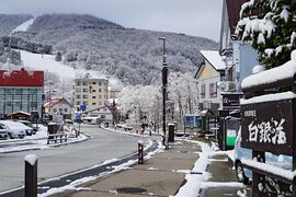
Ginzan Onsen (銀山温泉) is a Silver Mountain hot spring town located in the mountains of Obanazawa City, Yamagata Prefecture. The area originally developed around a silver mine. However, these days it is better known as one of Japan’s prettiest onsen towns with historic ryokan alongside river.[14]
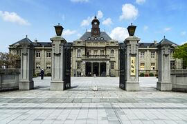
Former Yamagata Prefectural Office
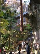
Yamadera niōmon
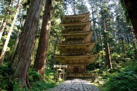
Mount Haguro, The Gojuto Pagoda
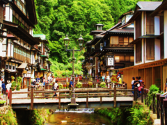
Ginzan Onsen Spa
Zaō Onsen Ski Resort


Media
Newspapers
TV and radio
Film
- Yamagata International Documentary Film Festival[15]
الهامش
- ^ Nussbaum, Louis-Frédéric. (2005). "Yamagata prefecture" in Japan Encyclopedia, pp. 1038-1039, p. 1038, في كتب گوگل; "Tōhoku" in p. 970, p. 970, في كتب گوگل
- ^ Nussbaum, "Yamagata" in p. 1038, p. 1038, في كتب گوگل
- ^ Nussbaum, "Provinces and prefectures" in p. 780, p. 780, في كتب گوگل
- ^ 自然公園都道府県別面積総括 [General overview of area figures for Natural Parks by prefecture] (PDF) (in اليابانية). Ministry of the Environment. 31 March 2020. Retrieved 22 September 2020.
- ^ Yamagata Station, Japan Meteorological Agency
- ^ Shinjo Station, Japan Meteorological Agency
- ^ Sakata Station, Japan Meteorological Agency
- ^ "Yamagata (Japan): Prefecture, Cities, Towns and Villages - Population Statistics, Charts and Map". www.citypopulation.de. Retrieved 2021-12-24.
- ^ "Current Population Estimates as of October 1, 2019". October 1, 2019.
{{cite web}}: CS1 maint: url-status (link) - ^ "2004np". Archived from the original (xls) on 20 May 2005. Retrieved 5 March 2023.
- ^ "Statistics Bureau of Japan". October 1, 2020.
{{cite web}}: CS1 maint: url-status (link) - ^ "Yamagata City". 9 May 2022.
- ^ "Yamagata: City unearths wealth of Buddhist Treasure". The Asahi Shimbun. December 5, 2006.[dead link]
- ^ "Ginzan Onsen". RGWords Travel & Photography Blog. 2021-02-21. Retrieved 2022-02-28.
- ^ "YIDFF Official Site". Yidff.jp. Retrieved 2014-02-14.
المراجع
- Nussbaum, Louis-Frédéric and Käthe Roth. (2005). Japan encyclopedia. Cambridge: Harvard University Press. ISBN 978-0-674-01753-5; OCLC 58053128
وصلات خارجية
- Yamagata Prefecture Official Website (in يابانية)
38°26′N 140°8′E / 38.433°N 140.133°E قالب:Yamagata

| International | |
|---|---|
| National | |
- CS1 uses اليابانية-language script (ja)
- CS1 اليابانية-language sources (ja)
- CS1 maint: url-status
- Articles with dead external links from May 2016
- Pages using gadget WikiMiniAtlas
- Short description is different from Wikidata
- Pages using multiple image with auto scaled images
- Pages using infobox settlement with no coordinates
- Articles with hatnote templates targeting a nonexistent page
- Articles with يابانية-language sources (ja)
- Coordinates on Wikidata
- Yamagata Prefecture
- Tōhoku region
- محافظات اليابان