أرض مطوقة أو منعزلة
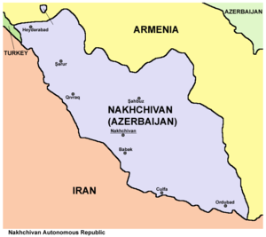
An enclave is a territory, or a part of a territory, that is entirely surrounded by the territory of one other state.[1] Territorial waters have the same sovereign attributes as land, and enclaves may therefore exist within territorial waters.[2] An exclave is a portion of a state or territory geographically separated from the main part by surrounding alien territory (of one or more states).[3] Many exclaves are also enclaves. Enclave is sometimes used improperly to denote a territory that is only partly surrounded by another state.[1] Vatican City and San Marino, enclaved by Italy, and Lesotho, enclaved by South Africa, are the only completely enclaved states. Unlike an enclave, an exclave can be surrounded by several states.[4]The Azeri exclave of Nakhchivan is an example of an exclave.
Semi-enclaves and semi-exclaves are areas that, except for possessing an unsurrounded sea border, would otherwise be enclaves or exclaves.[4][5] Enclaves and semi-enclaves can exist as independent states (Monaco, Gambia and Brunei are semi-enclaves), while exclaves always constitute just a part of a sovereign state.[4]
A pene-enclave is a part of the territory of one country that can be approached conveniently — in particular by wheeled traffic — only through the territory of another country.[6] Pene-enclaves are also called functional enclaves or practical enclaves.[5] Many pene-exclaves partially border their own territorial waters (i.e., they are not surrounded by other nations' territorial waters). A pene-enclave can also exist entirely on land, such as when intervening mountains render a territory inaccessible from other parts of a country except through alien territory. A commonly cited example is the Kleinwalsertal, a valley part of Vorarlberg, Austria, that is only accessible from Germany to the north.
Characteristics
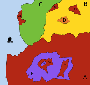
- A (red):
- possesses 3 exclaves (A1, A2 and A3): it is impossible to go from the main part of A to any of these parts going only through territory of A; however:
- A1 and A2 are not enclaves: neither of them is surrounded by a single "foreign" territory;
- A3 is an enclave: it is totally surrounded by B;
- contains 1 enclave (E): "foreign" territory totally surrounded by territory of A;
- possesses 2 counter-enclaves, or second-order enclaves (A4 and A5): territories belonging to A which are encroached inside the enclave E;
- contains 1 counter-counter-enclave, or third-order enclave (E1).
- possesses 3 exclaves (A1, A2 and A3): it is impossible to go from the main part of A to any of these parts going only through territory of A; however:
- B (yellow):
- contains 2 enclaves (A3 and D).
- C (green):
- continuous territory.
- D (orange):
- is an enclaved territory: it is territorially continuous, but its territory is totally surrounded by a single "foreign" territory (B).
- E (purple):
- is an enclaved territory: it is encroached inside A;
- contains 2 enclaves (A4 and A5), which are counter-enclaves of A;
- possesses 1 counter-enclave (E1), which is a counter-counter-enclave as viewed by A and contained within A5.
Enclaves exist for a variety of historical, political and geographical reasons. For example, in the feudal system in Europe, the ownership of feudal domains was often transferred or partitioned, either through purchase and sale or through inheritance, and often such domains were or came to be surrounded by other domains. In particular, this state of affairs persisted into the 19th century in the Holy Roman Empire, and these domains (principalities, etc.) exhibited many of the characteristics of sovereign states. Prior to 1866 Prussia alone consisted of more than 270 discontiguous pieces of territory.[2]
Enclave versus exclave
For illustration, in the figure (above), A1 is a semi-enclave (attached to C and also bounded by water that only touches C's territorial water). Although A2 is an exclave of A, it cannot be classed as an enclave because it shares borders with B and C. The territory A3 is both an exclave of A and an enclave from the viewpoint of B. The singular territory D, although an enclave, is not an exclave.
Enclaved countries
Three nations are completely surrounded by another country:
- The Republic of San Marino, enclaved within Italy
- Vatican City, enclaved within the city of Rome, Italy
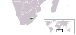
- The Kingdom of Lesotho, enclaved within South Africa
The Principality of Monaco is not an enclave, although it only borders France, because it possesses a coastline and territorial waters. For the same reason, Canada, The Gambia, and Portugal are also not enclaves.
Historically, four of the Bantustans (or "Black homelands") of South Africa were granted nominal independence, unrecognized internationally, by the Nationalist government from 1976 until their reabsorption in 1994. Others remained under government rule from 1948 to 1994. Being heavily partitioned, various parts of these Bantustans were true enclaves.
The United States' constitutional principle of tribal sovereignty treats federally-recognized Indian reservations as quasi-independent enclaves.
جيوب خارجية حقيقية
True exclave is an extension of the concept of true enclave. Examples include:
- Nakhchivan, which borders تركيا, Armenia and Iran, is an exclave of Azerbaijan.[7]
- In the United Arab Emirates, four emirates have five true exclaves: Dubai (Hatta), Ajmān (Masfut and Manama), Ras al-Khaimah (the southerly of the emirate's two non-contiguous sections), and Sharjah (Nahwa, also both a true national-level enclave and a counter-enclave).
- Llívia is an enclave and exclave of Spain surrounded by France.
- Campione d'Italia is an enclave and exclave of Italy surrounded by Switzerland.
- Büsingen am Hochrhein is an enclave and exclave of Germany surrounded by Switzerland. The shortest distance from Büsingen's borders to the main portion of German territory is only about 700 metres (about 2,300 ft).
- Likoma and Chizumulu Islands in Lake Malawi are lacustrine enclaves and exclaves of Malawi, surrounded by Mozambique territorial waters.[8]
Related constructs and terms
Enclaves within enclaves
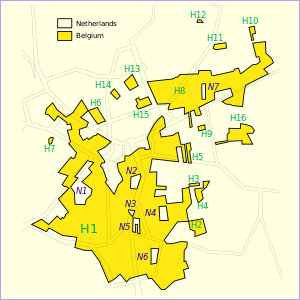
الجيوب العرقية
An ethnic enclave is a community of an ethnic group inside an area in which another ethnic group predominates. Ghettos, Little Italys, barrios and Chinatowns are examples. These areas may have a separate language, culture and economic system.
- Székely Land is a Hungarian ethnic enclave within Romania, with its people calling themselves Székely. Originally, the name Székely Land denoted an autonomous region within Transylvania. It existed as a legal entity from medieval times until the Austro-Hungarian Compromise of 1867, when the Székely and Saxon seats were dissolved and replaced by the county system. Along with Transylvania, it became a part of Romania in 1920, according with the Treaty of Trianon signed on 4 June 1920 at the Grand Trianon Palace in Versailles, France. In 1938–1940, during World War II, post-Trianon Hungary temporarily expanded its territory and included some additional territories that were formerly part of pre-war Kingdom of Hungary, under Third Reich auspices, the Second Vienna Award. It was later reduced to boundaries approximating those of 1920 by the peace treaties signed after World War II at Paris, in 1947. The area was called Magyar Autonomous Region between September 8, 1952 and February 16, 1968 a Hungarian autonomous region within Romania, and today there are territorial autonomy initiatives to reach a higher level of self-governance for this region within Romania.[بحاجة لمصدر]
- The 2008 film Silent Light depicts a Mennonite Flemish sect living within the Mexican state of Chihuahua, who speak a dialect called Plautdietsch.[بحاجة لمصدر]
- There are several Serb enclaves in Kosovo where the institutions of Kosovo are not fully operational due to disputes.[بحاجة لمصدر]
Extraterritoriality
Diplomatic missions, such as embassies and consulates, as well as military bases, are usually exempted from the jurisdiction of the host country, i.e., the laws of the host nation in which an embassy is located do not typically apply to the land of the embassy or base itself. This exemption from the jurisdiction of the host country is defined as extraterritoriality. Areas and buildings enjoying some forms of extraterritoriality are not true enclaves since, in all cases, the host country retains full sovereignty. In addition to embassies, some other areas enjoy a limited form of extraterritoriality.
Examples of this include:
- Pavillon de Breteuil in France, used by the General Conference on Weights and Measures.
- United Nations headquarters in the الولايات المتحدة, used by the United Nations.
- United Nations Office at Geneva in Switzerland, used by the United Nations.
- INTERPOL headquarters in Lyon, France, used by INTERPOL
- NATO (political) headquarters near Evere in Haren, a part of the City of Brussels, Belgium.
- Headquarters Allied Command Operations (NATO) at the area designated as Supreme Headquarters Allied Powers Europe (SHAPE), North of Mons, Belgium
- Palazzo Malta and the Villa del Priorato di Malta, the headquarters of Sovereign Military Order of Malta in Rome. In addition to extraterritoriality, Italy recognizes the exercise by SMOM of all the prerogatives of sovereignty in its headquarters. Therefore, Italian sovereignty and SMOM sovereignty uniquely coexist without overlapping.[9]
- Extraterritorial properties of the Holy See in Rome and surroundings.
- By treaty of 2 November 1929, Czechoslovakia obtained the lease for 99 years of two plots of land (in the Moldauhafen and in the Saalehafen), both within the perimeter of the free port of Hamburg. Another plot, in the Peutehafen, was purchased by the Czechoslovak government in 1929; this plot lies just outside the free-port perimeter.[10][11][12]
- Saalehafen – approximately 2 ha of land on Hallesches Ufer, on the southeastern bank of the Saalehafen
- Moldauhafen – approximately 0.5 ha of land on Dresdener Ufer, on the southeastern bank of the Moldauhafen
- Peutehafen – the narrow peninsula between the Peutekanal and the Peutehafen dock, comprising 8.054 ha of land and 0.5 ha of water surface
- In Szczecin, Poland, a similar provision existed following the Treaty of Versailles for Czechoslovakia to have access to the harbor, which until the end of World War II was located in Germany. From 1945, when Szczecin became part of Poland, Czechoslovakia possessed no extraterritorial rights there.[13] It appears that the German concession ceased at the end of the war and that no successor paid attention to the pre-war rights that Czechoslovakia had under the Versailles Treaty. Neither the Polish nor the occupying Russians appear to have assumed any of Germany's pre-war liabilities. Czechoslovakia gave up the rights to its territory in Szczecin under an agreement signed on 13 January 1956.[14]
- Saimaa Canal: the longitudinal half of the canal in Russia is leased by Finland until 2063. Russian law is in principle valid, but in reality Finland maintains the area.
أرض يملكها بلد أجنبي
Some areas of land in a country are owned by another country and in some cases it has special privileges, such as being exempt from taxes. These lands are not enclaves and do not have extraterritoriality since, in all cases, there is no transfer of sovereignty.
Examples of this include:
- Napoleon's original grave in Longwood, Saint Helena, owned by France.[15]
- The Brest memorial, in Brest, France, has been owned by the United States since the aftermath of World War I.
- Victor Hugo's house in St Peter Port, Guernsey, owned by the city of Paris.[16]
- The Normandy American Cemetery and Memorial in Normandy, France, which contains the graves of 9,386 American military dead, most of whom died during the landings and ensuing operations of World War II, owned by the United States of America.[17]
- Pointe du Hoc, 13-hectare site of a memorial and museum dedicated to the World War II Normandy landing at Omaha Beach, transferred by France to American control on 11 January 1979.[18]
- The Suvorov Memorial, near Göschenen in central Switzerland, was erected in 1899 by the Russian Empire.[19] The 563 m² area (449 m² rock and 114 m² access road) is Parcel No. 725 of the land register of Andermatt, owned by the Russian Embassy in Berne. The parcel is Swiss territory and fully subject to Swiss law.
- The Vimy Memorial in France, which commemorates the Battle of Vimy Ridge. The French government permanently granted a land area of about 91 ha (220 acre) to Canada as a war memorial in 1922 in recognition of Canada's military contributions in World War I in general and at Vimy Ridge in particular.[20]
- Two cemeteries on the Outer Banks of North Carolina, United States, one on Ocracoke Island and one on Hatteras Island in the town of Buxton, are owned by the United Kingdom. Both contain the graves of British seamen whose bodies washed ashore after World War II U-Boat attacks that occurred on 10 April (San Delfino – one body) and 11 May 1942 (HMT Bedfordshire – 5 bodies).[21] Four graves are at Ocracoke and two at Buxton; three of the bodies were never identified; one of them could be that of a Canadian seaman.[22] The plot of land at Ocracoke "has been forever ceded to England" and is maintained by the U.S. Coast Guard.[23] The plot was leased to the Commonwealth War Graves Commission for as long as the land remained a cemetery.[22] The graves on Hatteras Island are maintained by the U.S. National Park Service.[24]
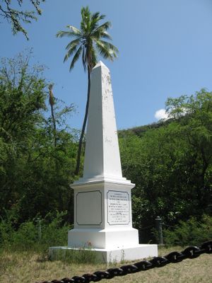
- The Captain Cook Monument at Kealakekua Bay and about 25 أقدام مربعة (2.3 m2) of land around it in Hawaii, United States, the place where James Cook was killed in 1779, is owned by the United Kingdom.[25][26][27][28] An historian on the occasion of the monument's 50th anniversary recorded in 1928 that the white stone "obelisk monument [was] erected to the memory of Captain Cook, about 1876, and on land deeded outright to the British Government by Princess Likelike, sister of King Kalakaua, about the same year, so that that square is absolute British Territory."[29] Hawaii was a sovereign nation at the time. According to a recent writer, "The land under the monument was deeded to the United Kingdom in 1877 and is considered as sovereign non-embassy land owned by the British Embassy in Washington DC. ... the Hawaiian State Parks agency maintained that as sovereign British territory it was the responsibility of the UK to maintain the site."[30]
- Tiwinza in Peru: In the 1998 peace agreement following the 1995 Cenepa War, Peru ceded to Ecuador the property, but not the sovereignty, of one square kilometer within Tiwinza (where 14 Ecuadorian soldiers were buried). Ecuador had established a frontier military outpost in Tiwinza, an area that was specified in the agreement as belonging to Peru.[31][32]
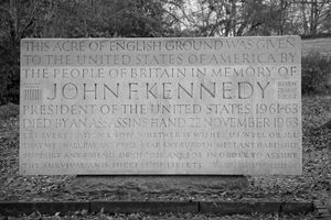
- The land under the John F. Kennedy memorial at Runnymede, United Kingdom was transferred from the Crown Estates to the United States of America by the John F. Kennedy Memorial Act 1964[33] (an Act of the UK Parliament) however it is in the care of the UK-based Kennedy Memorial Trust.[34]
- The Tomb of Suleyman Shah (the burial place of Suleyman Shah, the grandfather of Osman I, the founder of the Ottoman Empire) situated in Aleppo Governorate, Syria, is the property of تركيا. Article 9 of the Treaty of Ankara signed between France and Turkey in 1921, provides that the tomb "shall remain, with its appurtenances, the property of Turkey, who may appoint guardians for it and may hoist the Turkish flag there".[35]
Unusual cross-border transport channels
Highway of one state passing through another state's territory
This arrangement is less common as highways are more easily re-aligned. Examples include:
- Various roads crossing the border back and forth between the Republic of Ireland and Northern Ireland. The N54 in County Monaghan, Ireland twice becomes the A3 in County Fermanagh, NI, before continuing as the N54. Similarly, the N53 in Monaghan passes through County Armagh, NI as the A37, before resuming as the N53 at the border between Monaghan and County Louth, Ireland.[36] No national or county [محل شك] border signs are present.
- Congo Pedicle road: built to provide access for Zambia's Luapula Province to the Copperbelt through 70 كيلومتر (43 mi) of territory of the DR Congo, requiring a change in driving on the left to driving on the right.
- Between 1963 and 2002 the N274 road from Roermond to Heerlen, part of Dutch territory, passed through the German Selfkant, which had been annexed by the Netherlands after the Second World War but returned to Germany in 1963.
- Close to Narvik, a road from Norway twice enters and leaves Swedish territory, following the southern shore of the Kjårdavatnet lake. It does not connect with any other Swedish road in either location before it enters Norwegian land once more.[37][38]
- Road 402 between Podsabotin and Solkan in Slovenia, built when Slovenia was a state of Yugoslavia, passes through part of Italy. The road is confined by high concrete walls topped by fences; as Slovenia and Italy are now both signatories to the Schengen agreement, the barriers are little more than historical curiosities.
- The Saatse Boot Road in Estonia, between the villages of Lutepää and Sesniki, passes through Russian territory. The stretch of road passing through Russia is flanked by barbed wire fences and guard towers. Stopping and/or getting out of one's vehicle on the stretch of road is forbidden; the rule is enforced by Russian border guards.
- The road from Dubai to the tourist spot of Hatta, an exclave of the emirate of Dubai, passes through a small stretch of Omani territory.
- East Richford Slide Road in the US state of Vermont crosses in to the Canadian province of Québec for a distance of approximately 100 meters (300 feet) before returning to the United States.[39]
- The D8 coastal highway of Croatia passes through a small section of Herzegovina territory, at the Herzegovinian town of Neum, as it heads south from Split to Dubrovnik.
- In Guinea, where 20 km long tunnel(s) through a hillspur at Naigaya (elevation 411 متر (1،348 ft)), Sicourou, Bokariadi and Feraya might be avoided by crossing the border into Sierra Leone at Yana (elevation 87 متر (285 ft)).[بحاجة لمصدر]
- Senegal is practically and inconveniently divided in two by the sovereign territory of Gambia. The easiest way to travel from northern Senegal to the southern Casamance region is through Gambia via the Trans-Gambia Highway, with a connecting ferry being the only way to cross the Gambia River. The fare for the ferry crossing is a source of contention between the two countries.[40][41] In 2015, a road bridge is under construction.[42]
- The highway between Bishkek and Issyk Kul, both in Kyrgyzstan, skirts the border with Kazakhstan, with the highway and the border crossing each other for short distances at various points.
انظر أيضاً
Lists:
- List of enclaves and exclaves
- List of countries that border only one other country
- List of former foreign enclaves in China
- List of ethnic enclaves in North American cities
الهامش
- ^ أ ب Raton, Pierre (1958). "Les enclaves". Annuaire français de droit international. p. 186.
- ^ أ ب خطأ استشهاد: وسم
<ref>غير صحيح؛ لا نص تم توفيره للمراجع المسماةMelamid - ^ Exclave. Webster's Encyclopedic Unabridged Dictionary of the English Language, 1989, p. 497
- ^ أ ب ت Rozhkov-Yuryevsky, Yuri (2013). "The concepts of enclave and exclave and their use in the political and geographical characteristic of the Kaliningrad region". Baltic Region (2): 113–123. doi:10.5922/2079-8555-2013-2-11.
- ^ أ ب خطأ استشهاد: وسم
<ref>غير صحيح؛ لا نص تم توفيره للمراجع المسماةEV - ^ Robinson, G. W. S. (September 1959). "Exclaves". Annals of the Association of American Geographers. 49 (3, [Part 1]): 283–295. doi:10.1111/j.1467-8306.1959.tb01614.x. JSTOR 2561461.
- ^ "Assembly of Turkish American Associations". Ataa.org. Retrieved 2014-02-24.
- ^ "Malawi Tourism Guide". MalawiTMC. Retrieved 2017-05-08.
- ^ Arocha, Magaly (May 1999). "La Orden de Malta y su Naturaleza Jurídica (The Order of Malta and Its Legal Nature)". Caracas, Distrito Capital, Venezuela: Analítica.com. Retrieved October 1, 2012.
- ^ "Notification of the Ministry of Transport and Communications of the Czech Republic". 20 August 2001. Retrieved 2013-10-26.
- ^ Siebeck, Jürgen (23 October 2002). "Is Bohemia the sea?". Retrieved 2013-10-26.
- ^ Vališ, Zdeněk (28 April 2005). "Czech harbor in Hamburg, waiting for resurrection". Retrieved 2013-10-26.
- ^ "Czech leased areas in Hamburg and Stettin". Retrieved 2013-10-26.
- ^ "The Transport Agreement between the Czechoslovak Republic and the Polish People's Republic of 13 January 1956". Archived from the original on 2013-10-29. Retrieved 2013-10-26.
{{cite web}}: Unknown parameter|deadurl=ignored (|url-status=suggested) (help) - ^ "domaines français de Sainte-Hélène". Domfrance.helanta.sh. Archived from the original on 2011-03-25. Retrieved 2012-09-02.
{{cite web}}: Unknown parameter|deadurl=ignored (|url-status=suggested) (help) - ^ "Guernesey : Hauteville House". Paris.fr. 2012-08-28. Archived from the original on 2010-06-26. Retrieved 2012-09-02.
{{cite web}}: Unknown parameter|deadurl=ignored (|url-status=suggested) (help) - ^ Source:American Battle Monument Commission
- ^ "The American Battle Monuments Commission". "The site, preserved since the war by the French Committee of the Pointe du Hoc, which erected an impressive granite monument at the edge of the cliff, was transferred to American control by formal agreement between the two governments on 11 January 1979 in Paris, with Ambassador Arthur A. Hartman signing for the United States and Secretary of State for Veterans Affairs Maurice Plantier signing for France". Retrieved October 29, 2012.
- ^ "Suworow monument". Andermatt-Urserntal Tourism. Retrieved 2017-02-17.
- ^ "Canada And Vimy Ridge – Background Information – Veterans Affairs Canada". Retrieved 2012-04-09.
- ^ Hickam, Homer H. (1996). Torpedo Junction: U-Boat War Off America's East Coast, 1942. Naval Institute Press. pp. 202–207. ISBN 1-55750-362-1.
- ^ أ ب "British Cemetery at Ocracoke, North Carolina". Retrieved 2013-02-24.
- ^ "Historic Ocracoke Village – A Walking Tour". Retrieved 2013-02-24.
- ^ "British Cemeteries". Retrieved 2013-02-24.
- ^ Horwitz, Tony. Oct. 2003, Blue Latitudes: Boldly Going Where Captain Cook Has Gone Before, Bloomsbury, ISBN 0-7475-6455-8
- ^ Erickson, Lt Clayton, RCN (2012). "Captain Cook Monument at Kealakekua Cleaned and Repaired". Cook's Log. Vol. 35, no. 4. p. 38. Retrieved 2013-02-23.
{{cite news}}: CS1 maint: multiple names: authors list (link) - ^ "Canadian Crew Cleans Cook Monument". 30 August 2012. Retrieved 2013-02-23.
- ^ Harris, Francis (22 Jul 2006). "Don't mention the murder – how Hawaii forgot Capt. Cook". The Daily Telegraph. London. Retrieved 2013-02-23.
- ^ Taylor, Albert P. "HOW HAWAII HONORED CAPTAIN COOK, R.N., IN 1928". p. 29. Retrieved 2013-02-23.
- ^ MacFarlane, John M. (2012). "The Captain Cook Memorial at Kealakakua Bay Hawaii". Retrieved 2013-02-23.
- ^ "Cronologia de la Historia Resumida del Ecuador". Retrieved 15 Feb 2017.
- ^ Jimenez, Carmen (27 Oct 1998). "Los presidentes de Perú y Ecuador firman la paz en Brasilia y delimitan su frontera". El País. Retrieved 15 Feb 2017.
- ^ "John F. Kennedy Memorial Act". Google docs [unofficial copy]. Retrieved 2012-06-16.
- ^ Evans, D. M. Emrys (1965). "John F. Kennedy Memorial Act, 1964". The Modern Law Review. 28 (6): 703–706. JSTOR 1092388. (free registration required to read relevant text on page 704)
- ^ "Franco-Turkish agreement of Ankara" (PDF) (in French and English). Retrieved 8 August 2014.
{{cite web}}: CS1 maint: unrecognized language (link) - ^ 2006 Road Atlas Ireland, AA, pp. 36–37
- ^ Jan S. Krogh's Geosite on Sørdalen valley
- ^ "Driving directions". Google maps. Google. Retrieved 21 May 2015.
- ^ Google Maps
- ^ "Senegal may tunnel under Gambia". BBC News. 2005-09-21.
- ^ http://www.afdb.org/fileadmin/uploads/afdb/Documents/Project-and-Operations/Multinational__The_Gambia-Senegal__-_AR_-_Construction_of_the_Trans-Gambia_Bridge_and_Cross_Border_Improvement_.pdf
- ^ "Office of The Gambian President: State House Online: Yahya A.J.J. Jammeh". statehouse.gm. Archived from the original on 2015-08-08.
{{cite web}}: Unknown parameter|deadurl=ignored (|url-status=suggested) (help)
المراجع
- Robinson, G. W. S. (September 1959). "Exclaves". Annals of the Association of American Geographers. 49 (3, [Part 1]): 283–295. doi:10.1111/j.1467-8306.1959.tb01614.x. JSTOR 2561461.
{{cite journal}}: Invalid|ref=harv(help)
