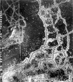
منطقة محرمة

منطقة محرمة (No man's land) هو لفظ يطلق على منطقة متنازع عليها طرفان ولأنهم لا يريدون احتلالها بسبب الخوف أو الشك. خلال الحرب العالمية الأولى استعمل هذا اللفظ لوصف المنطقة التي تقع بين خنادق طرفين متحاربين وكانت الأطراف المتنازعة تخاف السيطرة على المنطقة المحرمة أو التحرك فيها خشية تعرضها لهجوم من قبل العدو.
. . . . . . . . . . . . . . . . . . . . . . . . . . . . . . . . . . . . . . . . . . . . . . . . . . . . . . . . . . . . . . . . . . . . . . . . . . . . . . . . . . . . . . . . . . . . . . . . . . . . . . . . . . . . . . . . . . . . . . . . . . . . . . . . . . . . . . . . . . . . . . . . . . . . . . . . . . . . . . . . . . . . . . . .
التاريخ
استعملت لفظ المنطقة المحرمة خصوصاً خلال الحرب العالمية الأولى، ولكن أصل الكلمة يعود إلى القرن الرابع عشر حيث كان يصف منطقة كانت تقع خارج أسوار لندن الشمالية. كانت يتم في هذه المنطقة إعدام المجرمين وكان يتم ترك جثثهم مقطعة فيها كتحذير لمن يحاول الخروج عن القانون. وأطلق على هذه المنطقة اسم (No man's land) لأنه لم يكن أي شخص يدعي ملكيتها. بعد حوالي 400 سنة اطلق هذا اللفظ على منطقة صغيرة تستعمل في السفن يتم فيها خزن بعض الأدوات كالحبال وغيرها.
استعمل اللفظ لأول مرة في السياق العسكري سنة 1900 وذلك لتسمية منطقة تقع بين خندقين. خلال الحرب العالمية الأولى عرفت الكلمة استعمالاً واسعاً وكان ذكرها قد ورد في رسالة عاجلة في جريدة التايمز اللندنية كتبه الكولونل ارنست دنلوب سوينتون.
شكلت المنطقة المحرمة تجربة صعبة بالنسبة للجنود فهي قد تمدد مئات الأمتار كما تستطيع أن تصل إلى حوالي عشرة أمتار في بعض الأحيان. تكون جوانب المنطقة المحرمة مؤججة بالأسلحة الثقيلة والرشاشات كما يمكن أن تحتوي على ألغام أو على أسلاك شائكة. يمكن كذلك أن تكون المنطقة المحرمة مبعثرة بجثث جنود قد قتلوا أو جنود جرحوا ولم يستطيعوا العودة إلى خنادقهم.
أمثلة
الحرب العالمية الأولى
The British Army did not widely employ the term when the Regular Army arrived in France in August 1914, soon after the outbreak of World War I.[1] The terms used most frequently at the start of the war to describe the area between the trench lines included 'between the trenches' or 'between the lines'.[1] The term 'no man's land' was first used in a military context by soldier and historian Ernest Swinton in his short story "The Point of View".[2] Swinton used the term in war correspondence on the Western Front, with specific mention of the terms with respect to the Race to the Sea in late 1914.[1] The Anglo-German Christmas truce of 1914 brought the term into common use, and thereafter it appeared frequently in official communiqués, newspaper reports, and personnel correspondences of the members of the British Expeditionary Force.[1]
In World War I, no man's land often ranged from several hundred yards to in some cases less than 10 yards.[3] Heavily defended by machine guns, mortars, artillery, and riflemen on both sides, it was often extensively cratered, and was riddled with barbed wire, rudimentary improvised land mines, as well as corpses and wounded soldiers who were unable to make it through the hail of bullets, explosions, and flames. The area was sometimes contaminated by chemical weapons. It was open to fire from the opposing trenches and hard going generally slowed any attempted advance.
Not only were soldiers forced to cross no man's land when advancing, and as the case might be when retreating, but after an attack the stretcher bearers had to enter it to bring in the wounded. No man's land remained a regular feature of the battlefield until near the end of World War I, when mechanised weapons (i.e., tanks) made entrenched lines less of an obstacle.
Effects from World War I no man's lands persist today, for example at Verdun in France, where the Zone Rouge (Red Zone) contains unexploded ordnance, and is poisoned beyond habitation by arsenic, chlorine, and phosgene. The zone is sealed off completely and still deemed too dangerous for civilians to return: "The area is still considered to be very poisoned, so the French government planted an enormous forest of black pines, like a living sarcophagus", comments Alasdair Pinkerton, a researcher at Royal Holloway University of London, who compared the zone to the nuclear disaster site at Chernobyl, similarly encased in a "concrete sarcophagus".[4]
الحرب الباردة
تعتبر المنطقة التي كانت تقع وراء الستار الحديدي الذي كان يفصل بين القسم الشرقي ،السوفيتي والغربي من اوروبا خلال الحرب البادرة وقبل سقوط سور برلين.
القاعدة البحرية الأمريكية في گوانتانامو يفصلها ستار الصبار عن باقي كوبا. كما كان ستار الخيزران يفصل ڤيتنام الجنوبية عن ڤيتنام الشمالية.
تعتبر المنطقة الفاصلة بين الكوريتين الشمالية والجنوبية وهي منطقة خالية السلاح آخر منطقة محرمة حاليا.
إسرائيل-الأردن

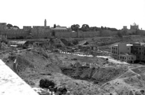
The 1949 Armistice Agreements between Israel and Transjordan were signed in Rhodes with the help of UN mediation on 3 April 1949.[5] Armistice lines were determined in November 1948. Between the lines territory was left that was defined as no man's land.[6][7] Such areas existed in Jerusalem in the area between the western and southern parts of the Walls of Jerusalem and Musrara.[8] A strip of land north and south of Latrun was also known as "no man's land" because it was not controlled by either Israel or Jordan between 1948 and 1967.[9]
انظر أيضاً
- بير طويل
- أرض محايدة
- Terra nullius، وهو تعبير قانوني يصف الأرض التي لا يطالب بها بلد، أو الأرض التي تخلى عنها مالك سابق
- Exclusion zone
- Jack's Land
- Kill zone
- List of established military terms
- No-go area
- Terra nullius
الهامش
- ملاحظات
- ^ أ ب ت ث Payne, David (8 July 2008). "No Man's Land". Western Front Association. Archived from the original on 29 October 2009. Retrieved 20 November 2009.
- ^ خطأ استشهاد: وسم
<ref>غير صحيح؛ لا نص تم توفيره للمراجع المسماةPersico 68 - ^ Hamilton, John (2003), Trench Fighting of World War I, ABDO, p. 8, ISBN 1-57765-916-3
- ^ خطأ استشهاد: وسم
<ref>غير صحيح؛ لا نص تم توفيره للمراجع المسماةbbc.com_2015-09-30 - ^ "S/1302/Rev.1 of 3 April 1949". Archived from the original on 2011-05-14. Retrieved 2017-06-28.
- ^ "Archived copy" (PDF). Archived (PDF) from the original on 2012-07-10. Retrieved 2012-09-22.
{{cite web}}: CS1 maint: archived copy as title (link) - ^ "Archived copy". Archived from the original on 2012-10-08. Retrieved 2012-09-26.
{{cite web}}: CS1 maint: archived copy as title (link) - ^ Hasson, Nir (30 October 2011). "Reclaiming Jerusalem's No-man's-land". Haaretz. Archived from the original on 9 February 2014.
- ^ "Palestinians for Peace and Democracy". www.p4pd.org. Archived from the original on 2014-11-11.


