ساراتوف
{{ safesubst:#invoke:Unsubst||date=__DATE__|$B=
Saratov
Саратов | |
|---|---|
.png&filetimestamp=20180719222704&) Top upper left:Holy Trinity Cathedral in Saratov Museum Square, Top lower left:Saratov Administration Office, Top right:Saratov Conservatory, Middle left:Saratovskaya Orthodox Theological Seminary, Middle right:Schmidt Mill, Bottom:A twilight view of Saratov Engels Bridge and Volga River | |
 Flag  Coat of arms | |
| النشيد: none[2] | |
Location of Saratov  | |
 Saratov Location of Saratov  Saratov Saratov (أوبلاست ساراتوڤ) | |
| Coordinates: 51°32′N 46°01′E / 51.533°N 46.017°E | |
| البلد | روسيا |
| الكيان الاتحادي | Saratov Oblast[1] |
| Founded | ca. 1590[3] |
| City status since | 1708[3] |
| Government | |
| • Body | City Duma[4] |
| • Head[4] | Mikhail Isayev[5] |
| Elevation | 50 m (160 ft) |
| Population | |
• Total | 837٬900 |
• Estimate (2018) | 844٬858 (+0٫8%) |
| • Rank | 16th in 2010 |
| • Subordinated to | city of oblast significance of Saratov[7][8] |
| • Capital of | أوبلاست ساراتوڤ[1], Saratovsky District[8] |
| • Urban okrug | Saratov Urban Okrug[9] |
| • Capital of | Saratov Urban Okrug[9], Saratovsky Municipal District[10] |
| Time zone | UTC+ ([11]) |
| Postal code(s)[12] | 410000–410005, 410007–410010, 410012, 410015, 410017–410019, 410022, 410023, 410025, 410028–410031, 410033–410042, 410047–410056, 410059, 410060, 410062–410065, 410068, 410069, 410071, 410074, 410076, 410078, 410080, 410082, 410086, 410700, 410880, 410890, 410899, 410960–410965, 410999 |
| Dialing code(s) | +7 8452 |
| OKTMO ID | 63701000001 |
| Website | www |
ساراتوڤ (Saratov ؛ UK: /səˈrɑːtɒf/ sə-RAH-tof,[13] US: /-təf/ --təf;[14][15] روسية: Саратов, تـُنطق [sɐˈratəf] (![]() استمع)) هي مدينة و المركز الاداري لأوبلاست ساراتوڤ، روسيا، وميناء رئيسي على نهر الڤولگا يقع أعلى (شمال) ڤولگوگراد. As of the 2021 Census[تحديث]، بلغ تعداد ساراتوف: 901,361 نسمة، مما يجعلها 17th-largest city in Russia by population. Saratov is 389 كيلومتر (242 mi) north of Volgograd, 442 كيلومتر (275 mi) south Samara, and 858 كيلومتر (533 mi) southeast of Moscow.
استمع)) هي مدينة و المركز الاداري لأوبلاست ساراتوڤ، روسيا، وميناء رئيسي على نهر الڤولگا يقع أعلى (شمال) ڤولگوگراد. As of the 2021 Census[تحديث]، بلغ تعداد ساراتوف: 901,361 نسمة، مما يجعلها 17th-largest city in Russia by population. Saratov is 389 كيلومتر (242 mi) north of Volgograd, 442 كيلومتر (275 mi) south Samara, and 858 كيلومتر (533 mi) southeast of Moscow.
The city stands near the site of Uvek, a city of the Golden Horde. Tsar Feodor I of Russia likely developed Saratov as a fortress to secure Russia's southeastern border. Saratov developed as a shipping port along the Volga and was historically important to the Volga Germans, who settled in large numbers in the city before they were expelled before and during World War II.
Saratov is home to a number of cultural and educational institutions, including the Saratov Drama Theater, Saratov Conservatory, Radishchev Art Museum, Saratov State Technical University, and Saratov State University.
أصل الاسم
The name Saratov may be derived from Sary Tau (Сары Тау), meaning "Yellow Mountain" in the Tatar language. Another version of the name origin derives it from the words Sar Atau, which means the "Boggy Island".[16]
التاريخ

![]() Russian Empire 1721–1917
Russian Empire 1721–1917
![]() Russian Republic 1917–1918
Russian Republic 1917–1918
![]() Russian Democratic Federal Republic 1918
Russian Democratic Federal Republic 1918![]() Russian Soviet Federative Socialist Republic 1918–1922
Russian Soviet Federative Socialist Republic 1918–1922
![]() Union of Soviet Socialist Republics 1918–1991
Union of Soviet Socialist Republics 1918–1991
Uvek, a city of the Golden Horde, stood near the site of the modern city of Saratov from the mid-13th century until its destruction by Tamerlane in 1395. While the exact date of the foundation of modern Saratov is unknown, plausible theories date it to ca. 1590,[3] during the reign (1584–1598) of Tsar Fyodor Ivanovich, who constructed several settlements along the Volga River in order to secure the southeastern boundary of his state. Town status was granted to it in 1708.[3]
By the 1800s, Saratov had grown to become an important shipping port on the Volga. The Ryazan-Ural Railroad reached Saratov in 1870.[17] In 1896, the line crossed the Volga and continued its eastward expansion. A unique train-ferry, owned by the Ryazan-Ural railroad, provided the connection across the river between the two ends of the railroad for 39 years, before the construction of a railway bridge in 1935.
During January 1915, with World War I dominating the Russian national agenda, Saratov became the destination for deportation convoys of ethnic Germans, Jews, Hungarians, Austrians and Slavs whose presence closer to the western front was perceived as a potential security risk to the state.[18]
During World War II, Saratov was a station on the north–south Volzhskaya Rokada, a specially designated military railroad supplying troops, ammunition and supplies to Stalingrad. In 1942-1943 the city was bombed by German aircraft. The main target was the Kirov oil refinery, which was heavily bombarded, seriously damaging the installation and destroying 80% of its plant and temporarily interrupting its work. The Luftwaffe was able to destroy all the fuel stock at bases in Saratov and eliminate the oil plant in the city.[19]
Until the end of the Soviet Union in 1991, the Soviet authorities designated Saratov a "closed city"; off-limits to all foreigners due to its military importance as the site of a vital facility manufacturing military aircraft.
الجالية الألمانية
لعبت مدينة ساراتوڤ دوراً هاماً في تاريخ ألمان الڤولگا. فحتى 1941، كانت بلدة پوكروڤسك (حالياً إنگلز)، الواقعة على الضفة المقابلة من نهر الڤولگا من ساراتوڤ، عاصمة جمهورية الڤولگا الألمانية. The ethnic German population of the region numbered 800,000 in the early 20th century, with some people whose families had been there for generations. Beginning with Catherine the Great's 1763 Manifesto promising land, freedom from military conscription and religious freedom, the Russian Emperors invited German immigration in the 18th and 19th centuries to encourage agricultural development.

The Volga German community came to include industrialists, scientists, musicians and architects, including those who built Saratov's universities and conservatories. After the beginning of the German invasion of the Soviet Union in June 1941, the Soviet government forcibly expelled the Volga Germans to Uzbekistan, Siberia and Kazakhstan (September 1941); few ever returned to the Volga region, even after rehabilitation. Others were expelled to western Europe after World War II ended in 1945.[citation needed]
Beginning in the 1980s, a large portion of the surviving members of the ethnic Germans emigrated from the Soviet Union to Germany.
Reminders of the once prominent place of Germans in the city remain, with the Roman Catholic St. Klementy Cathedral (seat of the historic Diocese of Tiraspol) on Nemetskaya Ulitsa ("German Street") the most notable. The building was converted into the children's cinema "Pioneer" during the Soviet period. A new cathedral was built in 2000 elsewhere in the city: the Cathedral of the Holy Apostles Peter and Paul in Saratov.
الوضع الاداري والبلدي
Saratov is the administrative center of the oblast[1] and, within the framework of administrative divisions, it also serves as the administrative center of Saratovsky District,[8] even though it is not a part of it.[20] As an administrative division, it is incorporated separately[20] as the city of oblast significance of Saratov—an administrative unit with the status equal to that of the districts.[7] As a municipal division, the city of oblast significance of Saratov is incorporated as Saratov Urban Okrug.[9]
الجغرافيا
المناخ
Saratov has a moderately continental climate with warm and dry summers and an abundance of sunny days. The warmest month is July with daily mean temperature near +23 °C (73 °F); the coldest is February, at −8 °C (18 °F).
Summers are hot and dry in Saratov. Daytime temperatures of +30 °C (86 °F) or higher are commonplace, up to +40.9 °C (105.6 °F) during a heat wave in 2010.
Snow and ice are dominant during the winter season. Days well above freezing and nights below −25 °C (−13 °F) both occur in the winter.
| بيانات المناخ لـ ساراتوڤ | |||||||||||||
|---|---|---|---|---|---|---|---|---|---|---|---|---|---|
| الشهر | ينا | فب | مار | أبر | ماي | يون | يول | أغس | سبت | أكت | نوف | ديس | السنة |
| القصوى القياسية °س (°ف) | 8.1 (46.6) |
7.3 (45.1) |
17.0 (62.6) |
31.1 (88.0) |
34.0 (93.2) |
39.5 (103.1) |
40.8 (105.4) |
40.9 (105.6) |
37.9 (100.2) |
25.1 (77.2) |
16.1 (61.0) |
11.7 (53.1) |
40.9 (105.6) |
| متوسط القصوى اليومية °س (°ف) | −4.8 (23.4) |
−4.7 (23.5) |
1.1 (34.0) |
13.3 (55.9) |
21.5 (70.7) |
26.2 (79.2) |
28.2 (82.8) |
26.6 (79.9) |
19.8 (67.6) |
11.1 (52.0) |
1.6 (34.9) |
−3.6 (25.5) |
11.4 (52.5) |
| المتوسط اليومي °س (°ف) | −7.8 (18.0) |
−8.1 (17.4) |
−2.5 (27.5) |
8.1 (46.6) |
15.7 (60.3) |
20.3 (68.5) |
22.4 (72.3) |
20.6 (69.1) |
14.3 (57.7) |
7.0 (44.6) |
−1.1 (30.0) |
−6.4 (20.5) |
6.9 (44.4) |
| متوسط الدنيا اليومية °س (°ف) | −10.6 (12.9) |
−11.1 (12.0) |
−5.6 (21.9) |
3.7 (38.7) |
10.4 (50.7) |
15.1 (59.2) |
17.2 (63.0) |
15.5 (59.9) |
9.9 (49.8) |
3.7 (38.7) |
−3.3 (26.1) |
−8.9 (16.0) |
3.0 (37.4) |
| الصغرى القياسية °س (°ف) | −37.3 (−35.1) |
−34.8 (−30.6) |
−26.8 (−16.2) |
−17.8 (0.0) |
−3.8 (25.2) |
2.2 (36.0) |
6.4 (43.5) |
4.3 (39.7) |
−2.9 (26.8) |
−12.6 (9.3) |
−24.7 (−12.5) |
−33.4 (−28.1) |
−37.3 (−35.1) |
| متوسط تساقط الأمطار mm (inches) | 41 (1.6) |
34 (1.3) |
31 (1.2) |
31 (1.2) |
35 (1.4) |
50 (2.0) |
49 (1.9) |
31 (1.2) |
49 (1.9) |
37 (1.5) |
46 (1.8) |
42 (1.7) |
476 (18.7) |
| Average rainy days | 6 | 5 | 7 | 12 | 14 | 15 | 14 | 12 | 13 | 14 | 12 | 8 | 132 |
| متوسط الرطوبة النسبية (%) | 84 | 81 | 78 | 64 | 55 | 59 | 59 | 59 | 64 | 74 | 84 | 84 | 70 |
| Mean monthly ساعات سطوع الشمس | 55.8 | 81.2 | 139.5 | 219.0 | 279.0 | 309.0 | 319.3 | 272.8 | 153.0 | 114.7 | 60.0 | 49.6 | 2٬052٫9 |
| Source 1: Pogoda.ru.net[21] | |||||||||||||
| Source 2: Hong Kong Observatory [22] | |||||||||||||
الاقتصاد والبنية التحتية

Saratov Oblast is highly industrialized, due in part to the richness in natural and industrial resources of the area. The oblast is also one of the more important and largest cultural and scientific centers in Russia. Saratov possesses six institutes of the Russian Academy of Sciences, twenty-one research institutes, nineteen project institutes, as well as the Saratov State University, the Saratov State Socio-Economic University, the Saratov State Technical University, and many scientific and technological laboratories attached to some of the city's large industrial enterprises. [citation needed]
النقل
Saratov is served by the Saratov Tsentralny Airport. The airport has flights to some international destinations and other Russian cities. Saratov West is a general aviation airfield. The aerospace manufacturing industry is served by the Saratov South airport. Nearby Engels Air Force Base is the main base for Russian strategic Tu-95 and Tu-160 bombers. Motorways link Saratov directly to Volgograd, Samara, and Voronezh. The railways also play an important role. The Privolzhskaya Railway is headquartered in Saratov. The Volga itself is an important inland waterway. Buses and trolleybuses form the backbone of public transport in the city.
-
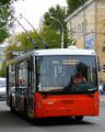 Trolza-5275 low-floor trolleybus
 -
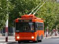 Trolza-5275 low-entry trolleybus
 -
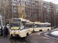 KTM-19 trams


التعليم

Saratov is host to a number of colleges and universities. These include the Saratov State University (1909), Saratov State Technical University, Saratov State Medical University, Saratov State Academy of Law and Saratov State Agrarian University . In 2014 a newly renovated campus for the Saratov Regional College of Art was opened.
الثقافة


.jpg&filetimestamp=20190307080511&)
One of the city's most prominent landmarks is the 19th century neo-Gothic Conservatory. When it was built in 1912, the Conservatory was Russia's third such institution (after Moscow and St. Petersburg). At the time, Saratov, with a population of 240,000, was the third-largest city in Russia.
The Saratov Drama Theater was founded in 1802, making it one of Russia's oldest. It is ranked as one of Russia's National Theaters. In Soviet times, the theater was renamed in honor of Karl Marx, but now carries the name of Ivan Slonov (1882–1945), an actor, theatrical director and educator, born in the city. The full name in Russian is The I. A. Slonov Saratov State Academic Theater (Саратовский государственный академический театр драмы имени И. А. Слонова).
Saratov is noted for several art museums, including the Radishchev Art Museum, named for Alexander Radishchev, Fedin Art Museum, named after Russian novelist Konstantin Fedin, Saratov Local History Museum, Chernyshevsky Estate Museum, named for Nikolay Chernyshevsky, and some others.. It contains more than 20,000 exhibits, including ancient Russian icons, as well as works by some of the finest Russian painters (e.g. Aleksandra Ekster, Pavel Kuznetsov, Aristarkh Lentulov, Robert Falk, Pyotr Konchalovsky, Martiros Saryan, Fyodor Rokotov).
الديمغرافيا
More than 90% of the city's population are ethnic Russians. Among the remainder are Tatars, Ukrainians, Armenians, Kazakhs and others.
الرياضة
Several sports clubs are active in the city:
| النادي | الرياضة | تأسس | الدوري الحالي | الترتيب في الدوري |
الملعب |
|---|---|---|---|---|---|
| Kristall Saratov | Ice Hockey | 1955 | Higher Hockey League | 2nd | Kirstall Sports Palace |
| Sokol Saratov | Football | 1930 | Russian Football National League | 2nd | Lokomotiv Stadium |
| Avtodor Saratov | Basketball | 1960 | VTB United League | 1st | Kirstall Sports Palace |
| Universal Saratov[23] | Bandy | 1953 | Bandy Supreme League | 2nd | Dynamo Stadium[24] |
| Proton Saratov | Volleyball | 1988 | Volleyball Superleague | 1st |
البلدات التوأم والمدن الشقيقة
ساراتوڤ متوأمة مع:
أبرز الأشخاص


- رومان أبراموڤتش، رجل أعمال
- Boris Andreyev, actor
- Oleg Antonov, aircraft designer
- Boris Babochkin, actor, director
- Rachel Bluwstein, poet
- Alexey Bogolyubov, painter
- Viktor Borisov-Musatov, painter
- Nikolay Chernyshevsky, philosopher
- Gavrila Derzhavin, poet
- Konstantin Fedin, writer
- Nikolai Grandkovsky, painter
- Joseph Hakobyan, engineer
- Lev Igorev, painter
- Anastasia Karpova, pop singer
- Lev Kassil, writer
- Kombinaciya, pop band
- Pavel Kuznetsov, painter
- Eduard Limonov, writer and politician
- Konstantin Paustovsky, writer
- Kuzma Petrov-Vodkin, painter
- Natalia Pogonina, chess player
- Jean-Victor Poncelet, French engineer and mathematician (POW)
- Alexander Radishchev, writer
- Lidiya Ruslanova, Russian folk singer
- Sweeney Schriner, ice hockey player
- Nikolay Semyonov, Nobel Prize-winning chemist
- Fyodor Shekhtel, architect
- Leonid Sobinov, composer
- Pyotr Stolypin, statesman
- Oleg Tabakov, actor
- Evgeny Tomashevsky, chess Grandmaster and former World number 15
- Valeriya, pop singer
- Nikolai Vavilov, biologist and geneticist, died in a Saratov jail
- Mikhail Vrubel, painter
- Oleg Yankovsky, actor
- Nikolay Zinin, chemist
- Zedd (musician), music producer and DJ, born in Saratov and moved to Germany.
- Elvira T, singer
- Katia Elizarova, model
الهامش
ملاحظات
- ^ أ ب ت ث Charter of Saratov Oblast, Article 10
- ^ The official symbols of Saratov enumerated in Article 3 of the Charter of Saratov do not include the anthem.
- ^ أ ب ت ث Энциклопедия Города России. Moscow: Большая Российская Энциклопедия. 2003. pp. 409–410. ISBN 5-7107-7399-9.
- ^ أ ب Charter of Saratov, Article 22
- ^ Official website of Saratov. Mikhail Aleksandrovich Isayev, Head of Saratov (بالروسية)
- ^ Russian Federal State Statistics Service (2011). "Всероссийская перепись населения 2010 года. Том 1". Всероссийская перепись населения 2010 года (2010 All-Russia Population Census) (in Russian). Federal State Statistics Service. Retrieved June 29, 2012.
{{cite web}}: Invalid|ref=harv(help); Unknown parameter|trans_title=ignored (|trans-title=suggested) (help)CS1 maint: unrecognized language (link) - ^ أ ب Law #21-ZSO
- ^ أ ب ت Государственный комитет Российской Федерации по статистике. Комитет Российской Федерации по стандартизации, метрологии и сертификации. №ОК 019-95 1 января 1997 г. «Общероссийский классификатор объектов административно-территориального деления. Код 63 243», в ред. изменения №278/2015 от 1 января 2016 г.. (State Statistics Committee of the Russian Federation. Committee of the Russian Federation on Standardization, Metrology, and Certification. #OK 019-95 January 1, 1997 Russian Classification of Objects of Administrative Division (OKATO). Code 63 243, as amended by the Amendment #278/2015 of January 1, 2016).
- ^ أ ب ت Law #79-ZSO
- ^ Law #78-ZSO
- ^ "Об исчислении времени". Официальный интернет-портал правовой информации (in Russian). 3 June 2011. Retrieved 19 January 2019.
{{cite web}}: CS1 maint: unrecognized language (link) - ^ Почта России. Информационно-вычислительный центр ОАСУ РПО. (Russian Post). Поиск объектов почтовой связи (Postal Objects Search) (in روسية)
- ^ "Saratov". Lexico UK English Dictionary. Oxford University Press. Archived from the original on 2020-03-22.
- ^ "Saratov". The American Heritage Dictionary of the English Language (5th ed.). HarperCollins. Retrieved 13 August 2019.
- ^ "Saratov". Merriam-Webster.com Dictionary. Merriam-Webster. OCLC 1032680871. Retrieved 13 August 2019.
- ^ Путешествие по России [Travel to Russia] (in الروسية). Archived from the original on 2013-05-14. Retrieved 2008-12-29.
- ^ Тамбовско-Саратовская линия (in Russian)
- ^ Sergej G.: "Die Politik Russlands gegenüber den Deutschen 1914–1918." In: Eisfeld, Alfred et al. [Hrsg.] Deutsche in Russland und in der Sowjetunion 1914–1941. Lit Verlag, Berlin 2007.
- ^ «Волжская рокада». Линия Иловля - Саратов - Сызрань - Ульяновск - Свияжск (in Russian)
- ^ أ ب Государственный комитет Российской Федерации по статистике. Комитет Российской Федерации по стандартизации, метрологии и сертификации. №ОК 019-95 1 января 1997 г. «Общероссийский классификатор объектов административно-территориального деления. Код 63 401», в ред. изменения №278/2015 от 1 января 2016 г.. (State Statistics Committee of the Russian Federation. Committee of the Russian Federation on Standardization, Metrology, and Certification. #OK 019-95 January 1, 1997 Russian Classification of Objects of Administrative Division (OKATO). Code 63 401, as amended by the Amendment #278/2015 of January 1, 2016).
- ^ "Pogoda.ru.net" (in Russian). Retrieved September 8, 2007.
{{cite web}}: CS1 maint: unrecognized language (link) - ^ Climatological Norms of Saratov [1]. Retrieved on August 24, 2011.
- ^ [2]
- ^ [3]
- ^ "Sister Cities". Dallas-ecodev.org. Retrieved May 23, 2010.
- ^ (نشطت في مطلع ع1950)
- ^ "Wuhan - Saratov, Russia".
المصادر
- Саратовская областная Дума. Закон №46-ЗСО от 2 июня 2005 г. «Устав (Основной Закон) Саратовской области», в ред. Закона №54-ЗСО от 28 апреля 2015 г. «О внесении изменений в Устав (Основной Закон) Саратовской области». (Saratov Oblast Duma. Law #46-ZSO of June 2, 2005 Charter (Basic Law) of Saratov Oblast, as amended by the Law #54-ZSO of April 28, 2015 On Amending the Charter (Basic Law) of Saratov Oblast).
- قالب:RussiaBasicLawRef/sar/saratov
- Саратовская областная Дума. Закон №21-ЗСО от 3 апреля 2000 г. «Об административно-территориальном устройстве Саратовской области», в ред. Закона №15-ЗСО от 4 февраля 2014 г. «О внесении изменений в Закон Саратовской области "Об административно-территориальном устройстве Саратовской области"». (Saratov Oblast Duma. Law #21-ZSO of April 3, 2000 On the Administrative-Territorial Structure of Saratov Oblast, as amended by the Law #15-ZSO of February 4, 2014 On Amending the Law of Saratov Oblast "On the Administrative-Territorial Structure of Saratov Oblast").
- Саратовская областная Дума. Закон №79-ЗСО от 23 декабря 2004 г «О городских округах». (Saratov Oblast Duma. Law #79-ZSO of December 23, 2004 On the Urban Okrugs).
- Саратовская областная Дума. Закон №78-ЗСО от 23 декабря 2004 г «О муниципальных районах». (Saratov Oblast Duma. Law #78-ZSO of December 23, 2004 On the Municipal Districts).
وصلات خارجية
- Pages using gadget WikiMiniAtlas
- CS1 errors: unsupported parameter
- Articles containing روسية-language text
- Articles with روسية-language sources (ru)
- CS1 uses الروسية-language script (ru)
- CS1 الروسية-language sources (ru)
- Short description matches Wikidata
- Short description is different from Wikidata
- Pages using infobox mapframe without shape links in Wikidata
- Coordinates on Wikidata
- Pages using infobox settlement with image map1 but not image map
- Pages using Lang-xx templates
- مقالات فيها عبارات متقادمة منذ 2010
- جميع المقالات التي فيها عبارات متقادمة
- Articles with unsourced statements from October 2015
- Articles with unsourced statements from March 2014
- ساراتوف
- محافظة ساراتوف
- أماكن مأهولة على الڤولگا
- مدن وبلدات في أبلاست ساراتوف
- صفحات مع الخرائط