كالي، كولومبيا
Cali, Colombia | |
|---|---|
Municipality | |
| Santiago de Cali | |
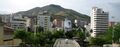
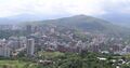
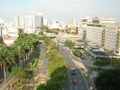
      From the top: Cali night skyline, Enrique Buenaventura Municipal Theater, San Antonio Church, El Gato del Río, Cristo Rey and Central Panoramic view. | |
 Flag  الشعار | |
| الكنية: "The Salsa capital of the world", "Capital of Happiness", "Sports Capital of Colombia", "Branch of heaven", "The Sultana of the Valley" | |
 Location of the municipality and city of Cali in the Valle del Cauca Department. | |
 Cali, Colombia Location in Colombia | |
| Coordinates: 3°25′14″N 76°31′20″W / 3.42056°N 76.52222°W | |
| Country | Colombia |
| Department | Valle del Cauca |
| Foundation | 25 July 1536 |
| Founded by | Sebastián de Belalcázar |
| Government | |
| • Mayor | Jorge Iván Ospina |
| Area | |
• Municipality | 619 كم² (239 ميل²) |
| Elevation | 1٬018 m (3٬340 ft) |
| Population (2018)[1] | |
• Municipality | 2٬227٬642 |
| • Rank | Ranked 3rd |
| • Density | 3٬600/km2 (9٬300/sq mi) |
| • Metro | 3٬400٬000 (2٬012) |
| Demonym | Caleño |
| Time zone | UTC-5 (COT) |
| Area code | +57 2 |
| HDI (2010) | 0.910– very high |
| Website | Official website (in إسپانية) |
Santiago de Cali (النطق الإسپاني: [sanˈtjaɣo ðe ˈkali]), or Cali, is the capital of the Valle del Cauca department, and the most populous city in southwest Colombia, with 2,227,642 residents according to the 2018 census.[1] The city spans 560.3 km2 (216.3 sq mi) with 120.9 km2 (46.7 sq mi) of urban area,[2] making Cali the second-largest city in the country by area and the third most populous. As the only major Colombian city with access to the Pacific Coast, Cali is the main urban and economic center in the south of the country, and has one of Colombia's fastest-growing economies.[3][4][5] The city was founded on 25 July 1536 by the Spanish explorer Sebastián de Belalcázar.
Cali is also a center for sports in Colombia, and is the only Colombian city to have hosted the Pan American Games. It hosted the 1992 World Wrestling Championships, the ninth edition of the World Games in 2013, the UCI Track Cycling World Championships in 2014 and the World Youth Championships in Athletics in 2015. The city is to host the first ever Junior Pan American Games in 2021.
أصل الاسم
Cali is the shortened form of the official name of the city: Santiago de Cali. "Santiago" honours Saint James whose feast day is celebrated on the 25th of July. The origin of the word "Cali" comes from the local Amerindians the "Calima".
التاريخ
هذا القسم يحتاج المزيد من الأسانيد للتحقق. (July 2020) (Learn how and when to remove this template message) |
Pre-Columbian era and settlers

Before the arrival of the Spaniards, the region was inhabited by indigenous tribes, mostly speakers of Cariban languages. In the region between the Cauca River and the Western Cordillera, the Gorrones established themselves between the present day Roldanillo and Santiago de Cali. The biggest town of the Morrones was sited on the River Pescador near the present-day towns of Zarzal and Bugalagrande. The Morrones traded with the Quimbayas who inhabited the north of the Valle del Cauca.
Geography and climate
Location
Cali is located on the Cauca Valley to the west of the Cauca River and to the east of the Western Mountain Range near the hills known as Farallones de Cali. The city rests approximately 1،000 متر (3،281 أقدام) above sea level. Approximately 100 كيلومتر (62 ميل) west of Cali and over the Western Cordillera, lies the port city of Buenaventura on the Colombian Pacific coast. To the northeast are the manufacturing center of Yumbo and Cali's international airport, the Alfonso Bonilla Aragón (CLO). It is Colombia's third-largest airport in terms of passengers, transporting 2,667,526 in 2009.
الجغرافيا

المناخ

| بيانات المناخ لـ Santiago de Cali (Alfonso Bonilla Aragón International Airport) 1981–2010 | |||||||||||||
|---|---|---|---|---|---|---|---|---|---|---|---|---|---|
| الشهر | ينا | فب | مار | أبر | ماي | يون | يول | أغس | سبت | أكت | نوف | ديس | السنة |
| القصوى القياسية °س (°ف) | 36.3 (97.3) |
36.5 (97.7) |
36.4 (97.5) |
34.5 (94.1) |
33.2 (91.8) |
35.3 (95.5) |
36.6 (97.9) |
35.7 (96.3) |
35.0 (95.0) |
34.4 (93.9) |
32.8 (91.0) |
34.5 (94.1) |
36.6 (97.9) |
| متوسط القصوى اليومية °س (°ف) | 29.9 (85.8) |
30.2 (86.4) |
30.1 (86.2) |
29.5 (85.1) |
29.3 (84.7) |
29.5 (85.1) |
30.1 (86.2) |
30.7 (87.3) |
30.2 (86.4) |
29.2 (84.6) |
28.9 (84.0) |
29.2 (84.6) |
29.7 (85.5) |
| المتوسط اليومي °س (°ف) | 24.0 (75.2) |
24.2 (75.6) |
24.2 (75.6) |
23.9 (75.0) |
23.9 (75.0) |
23.9 (75.0) |
24.1 (75.4) |
24.3 (75.7) |
24.1 (75.4) |
23.5 (74.3) |
23.4 (74.1) |
23.6 (74.5) |
23.9 (75.0) |
| متوسط الدنيا اليومية °س (°ف) | 18.9 (66.0) |
19.0 (66.2) |
19.2 (66.6) |
19.2 (66.6) |
19.2 (66.6) |
18.9 (66.0) |
18.4 (65.1) |
18.5 (65.3) |
18.7 (65.7) |
18.8 (65.8) |
18.8 (65.8) |
18.9 (66.0) |
18.9 (66.0) |
| الصغرى القياسية °س (°ف) | 14.4 (57.9) |
15.2 (59.4) |
14.0 (57.2) |
14.6 (58.3) |
16.0 (60.8) |
15.1 (59.2) |
13.6 (56.5) |
13.4 (56.1) |
14.2 (57.6) |
15.0 (59.0) |
15.0 (59.0) |
15.0 (59.0) |
13.4 (56.1) |
| متوسط تساقط الأمطار mm (inches) | 51.3 (2.02) |
56.0 (2.20) |
92.0 (3.62) |
129.3 (5.09) |
96.5 (3.80) |
55.1 (2.17) |
31.7 (1.25) |
35.3 (1.39) |
70.1 (2.76) |
101.8 (4.01) |
101.2 (3.98) |
67.9 (2.67) |
888.2 (34.97) |
| Average precipitation days | 10 | 9 | 14 | 17 | 15 | 10 | 8 | 8 | 12 | 16 | 15 | 12 | 144 |
| متوسط الرطوبة النسبية (%) | 73 | 72 | 73 | 76 | 76 | 75 | 73 | 71 | 72 | 75 | 76 | 75 | 74 |
| Mean monthly ساعات سطوع الشمس | 179.8 | 158.2 | 161.2 | 141.0 | 142.6 | 150.0 | 182.9 | 189.1 | 159.0 | 155.0 | 153.0 | 164.3 | 1٬936٫1 |
| المتوسط اليومي ساعات سطوع الشمس | 5.8 | 5.6 | 5.2 | 4.7 | 4.6 | 5.0 | 5.9 | 6.1 | 5.3 | 5.0 | 5.1 | 5.3 | 5.3 |
| Source: Instituto de Hidrologia Meteorologia y Estudios Ambientales[6][7][8] | |||||||||||||
Tourism
| Cali Tower | |
|---|---|
 | |
 | |
| معلومات عامة | |
| الإحداثيات | 3°27′32.40″N 76°31′44.4″W / 3.4590000°N 76.529000°W |
| اكتمل | 1984 |
| التصميم والإنشاء | |
| المعماري | Jaime Vélez |
| المطور | Julián Echeverri cía. |
| المهندس الإنشائي | Enrique Martínez Romero |

الاقتصاد
Cali and Valle del Cauca constitute the third largest center national and international economic exchange in Colombia. The city is an important stop on way to Ecuador, and is connected with the world through the seaport of Buenaventura.

Economic history
The economic transformation of Cali and the Valle del Cauca during the twentieth century and its crisis of the century, and the outlook to the new century have been the subject of deep analysis of financial and academic institutions. This section is based on the analysis and recommendations of the report Cali Colombia – Toward a City Development and Strategy published by the World Bank in 2002, and the Regional Economic Situation Reports (ICER) published quarterly by the DANE.
Colombia's sports capital


Santiago de Cali is recognized as the sports capital of Colombia. It is the first Colombian city to have hosted the Pan American Games (see 1971 Pan American Games), and has also won the National Olympic Games more than any other region in Colombia. The city also counts with one of the most developed sport infrastructures in the country. Many sporting events have taken place in the city.
Nicknames
- (in إسپانية) Capital Mundial de la Salsa (Salsa Capital of the World)
- (in إسپانية) La Sucursal del Cielo (Branch Office of Heaven)
- (in إسپانية) La Sultana del Valle (the Empress of the Valley)
- (in إنگليزية) Cali Beach
- (in إنگليزية) Caliwood
International relations
هذا القسم يحتاج المزيد من الأسانيد للتحقق. (July 2015) (Learn how and when to remove this template message) |
Twin towns – Sister cities
|
|
|
Gallery
-
 Tres Cruces Hill
 -
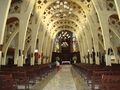 San Fernando church interior
 -
 (Library) Biblioteca departamental Jorge Garcés Borrero
 -
 Western Cali, looking Cristo Rey Hill
 -
 Cali river
 -
 Skyline picture taken from Cristo Rey Hill


Notable people
- Andrés Andrade (born 1989), footballer
- Andrés Caicedo (1951–1977), writer
- Lupe Fuentes (born 1987), house music producer
- José Gilberto Montoya, medical researcher
- César Mora (born 1961), musician
- Gilberto Rodriguez Orejuela (born 1939), one of the former leaders of the Cali Cartel
- Viviana Serna (born 1990), actress
- Julio César Tobar (born 1978), footballer
- Carlos Valdes (born 1989), actor
- Mario Yepes (born 1976), footballer
References
- ^ أ ب https://www.dane.gov.co/files/varios/informacion-capital-DANE-2019.pdf
- ^ CALI EN CIFRAS 2011– ALCALDÍA DE SANTIAGO DE CALI (DEPARTAMENTO ADMINISTRATIVO DE PLANEACIÓN)
- ^ "Metrocuadrado". Metrocuadrado. Archived from the original on 7 فبراير 2019. Retrieved 16 يناير 2019.
- ^ net, From (21 فبراير 2005). "Cali: Capital Mundial de la Salsa o La Sucursal del Cielo". salsa.ch. Archived from the original on 16 يناير 2019. Retrieved 16 يناير 2019.
- ^ "Cali ratificó ser la capital mundial de la salsa – HSB Noticias". hsbnoticias.com. 1 أكتوبر 2012. Archived from the original on 16 يناير 2019. Retrieved 16 يناير 2019.
- ^ "Promedios Climatológicos 1981–2010" (in الإسبانية). Instituto de Hidrologia Meteorologia y Estudios Ambientales. Archived from the original on 15 أغسطس 2016. Retrieved 15 أغسطس 2016.
- ^ "Promedios Climatológicos 1971–2000" (in الإسبانية). Instituto de Hidrologia Meteorologia y Estudios Ambientales. Archived from the original on 15 أغسطس 2016. Retrieved 15 أغسطس 2016.
- ^ "Tiempo y Clima" (in الإسبانية). Instituto de Hidrologia Meteorologia y Estudios Ambientales. Archived from the original on 15 أغسطس 2016. Retrieved 15 أغسطس 2016.
Bibliography
وصلات خارجية
| Find more about Cali at Wikipedia's sister projects | |
| Definitions from Wiktionary | |
| Media from Commons | |
| Quotations from Wikiquote | |
| Source texts from Wikisource | |
| Textbooks from Wikibooks | |
| Travel guide from Wikivoyage | |
| Learning resources from Wikiversity | |
المدن المضيفة لدورة الألعاب الأمريكية | |
|---|---|
مدن استضافت الألعاب العالمية | |
|---|---|
| International | |
|---|---|
| National | |
- Pages using gadget WikiMiniAtlas
- CS1 الإسبانية-language sources (es)
- Use dmy dates from February 2020
- Short description is different from Wikidata
- Coordinates on Wikidata
- Articles with إسپانية-language sources (es)
- Pages using infobox settlement with unknown parameters
- Articles with hatnote templates targeting a nonexistent page
- Articles needing additional references from July 2020
- All articles needing additional references
- المقالات needing additional references from June 2020
- كل المقالات needing additional references
- Articles with إنگليزية-language sources (en)
- Articles needing additional references from July 2015
- Articles with unsourced statements from July 2015
- Cali
- Municipalities of Valle del Cauca Department
- Populated places established in 1536
- عواصم محافظات كولومبيا
- 1536 establishments in the Spanish Empire
- 1536 establishments in South America
- صفحات مع الخرائط