ولاية جزائر بحر إيجة
| ولاية جزائر بحر إيجة
ولايت جزائر بحر سفيد Vilâyet-i Cezair-i Bahr-i Sefid | |||||||||||||
|---|---|---|---|---|---|---|---|---|---|---|---|---|---|
| ولاية الدولة العثمانية | |||||||||||||
| 1864–1912 | |||||||||||||
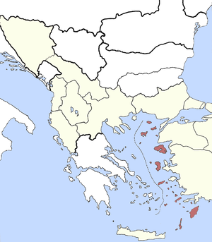
 ولاية جزائر بحر إيجة في عقد 1880 | |||||||||||||
| العاصمة | رودس[1] | ||||||||||||
| المساحة | |||||||||||||
• 1885[2] | 12،850 km2 (4،960 sq mi) | ||||||||||||
| التعداد | |||||||||||||
• 1885[2] | 325866 | ||||||||||||
| التاريخ | |||||||||||||
| التاريخ | |||||||||||||
• Established | 1864 | ||||||||||||
• Disestablished | 1912 | ||||||||||||
| |||||||||||||
| المنطقة لا تشمل قبرص | |||||||||||||
ولاية جزائر بحر إيجة، هي إحدى ولايات الدولة العثمانية، At the beginning of the 20th century, it reportedly had an area of 4,963 square miles (12,850 km2), while the preliminary results of the first Ottoman census of 1885 (published in 1908) gave the population as 325,866.[2] The accuracy of the population figures ranges from "approximate" to "merely conjectural" depending on the region from which they were gathered.[2]
It was established in 1864 as the successor of the homonymous "Eyalet of the Archipelago" which was established in the mid-16th century.[citation needed] It covered the Aegean islands held by the empire and was under the direct control of the Kapudan Pasha, the commander-in-chief of the Ottoman Navy.
The vilayet encompassed the islands of the eastern Aegean Sea (Imbros, Tenedos, Lemnos, Lesbos, Chios and the Dodecanese) as well as Cyprus. It was subdivided into five sanjaks: Rhodes, Chios, Lesbos, Lemnos and Cyprus. Cyprus was soon separated into an independent mutasarrıflık in 1870; it then came under British administration in 1878 by the terms of the Treaty of Berlin. The Dodecanese were occupied by Italy in the Italo-Turkish War of 1911–1912, and the remaining islands were captured by Greece during the First Balkan War (1912–1913).
التقسيمات الإدارية
سناجق الولاية:[3]
انظر أيضا
المصادر
- ^
 Chisholm, Hugh, ed. (1911). "Rhodes". دائرة المعارف البريطانية (eleventh ed.). Cambridge University Press.
 {{cite encyclopedia}}: Cite has empty unknown parameter:|coauthors=(help) - ^ خطأ استشهاد: وسم
<ref>غير صحيح؛ لا نص تم توفيره للمراجع المسماةasia - ^ Cezâir-i Bahr-i Sefid Vilâyeti | Tarih ve Medeniyet
وصلات خارجية
 Media related to Vilayet of the Archipelago at Wikimedia Commons
- مقالات المعرفة المحتوية على معلومات من دائرة المعارف البريطانية طبعة 1911
- Former country articles requiring maintenance
- Pages using infobox former subdivision with unknown parameters
- Turkey articles missing geocoordinate data
- All articles needing coordinates
- ولايات الدولة العثمانية في آسيا
- ولايات الدولة العثمانية في اوروپا
- تاريخ بحر إيجة
- تاريخ قبرص
- تاريخ محافظة چنققلعه
- تاريخ رودس
- تاريخ الجزر الاثنا عشرية
- تأسيسات 1864 في الدولة العثمانية