بورغون-فرانش-كونتيه
بورگون-فرانش-كونتيه
Bourgogne-Franche-Comté | |
|---|---|
    مع عقارب الساعة من أعلى: كاتدرائية سان جان في بزانسون؛ مسرح Lons-le-Saunier؛ جسر اللوار والكاتدرائية في نڤير؛ ومنظر ديجون | |
 Flag  Coat of arms | |
 | |
| البلد | |
| Regional council seat | بزانسون |
| Prefecture | ديجون |
| أقاليم | |
| الحكومة | |
| • President of the Regional Council | Marie-Guite Dufay (Socialist Party) |
| المساحة | |
| • الإجمالي | 47٬784 كم² (18٬450 ميل²) |
| ترتيب المساحة | 6th |
| التعداد (2015) | |
| • الإجمالي | 2٬820٬940 |
| • الكثافة | 59/km2 (150/sq mi) |
| منطقة التوقيت | UTC+01:00 (CET) |
| • الصيف (التوقيت الصيفي) | UTC+02:00 (CEST) |
| ISO 3166 code | FR-BFC |
| GDP | Ranked 11 of 18 |
| Total | 76.6 € billion (EUR€ bn) |
| Per capita | 24,200 € (EUR€) |
| الموقع الإلكتروني | www |
بورغون-فرانش-كونتيه (بالفرنسية: [buʁɡɔɲ fʁɑ̃ʃ kɔ̃te] (![]() استمع)؛ حرفياً 'Burgundy-Free County')، اختصارها " BFC " ، منطقة في شرق فرنسا أنشئت في الإصلاح الإقليمي للمناطق الفرنسية في 2014 ، من اندماج بورجندي وفرانش-كونتيه. دخلت المنطقة الجديدة إلى حيز الوجود في 1 يناير 2016، بعد الانتخابات الإقليمية في ديسمبر 2015 ، حيث تم انتخاب 100 عضو في المجلس الإقليمي في بورگون-فرانش-كونتيه.[1]
استمع)؛ حرفياً 'Burgundy-Free County')، اختصارها " BFC " ، منطقة في شرق فرنسا أنشئت في الإصلاح الإقليمي للمناطق الفرنسية في 2014 ، من اندماج بورجندي وفرانش-كونتيه. دخلت المنطقة الجديدة إلى حيز الوجود في 1 يناير 2016، بعد الانتخابات الإقليمية في ديسمبر 2015 ، حيث تم انتخاب 100 عضو في المجلس الإقليمي في بورگون-فرانش-كونتيه.[1]
المنطقة تغطي مساحة قدرها47،784 km2 (18،450 sq mi)؛ كان عدد سكانها 2,811,423 نسمة في عام 2017.[2] Its prefecture and largest city is Dijon, although the regional council sits in Besançon, making Bourgogne-Franche-Comté one of two regions in France (along with Normandy) in which the prefect does not sit in the same city as the regional council.
أسماء المواقع الجغرافية
The text of the territorial reform law gives interim names for most of the merged regions, combining the names of their constituent regions separated by hyphens. Permanent names would be proposed by the new regional councils and confirmed by the Conseil d'État by 1 October 2016.[3] Hence the interim name of the new administrative region is composed of the names of former administrative regions of Burgundy (Bourgogne) and Franche-Comté. The region chose to retain its interim name as its permanent name, a decision made official by the Conseil d'État on 28 September 2016.[4]
The merger represents a historic reunification of the Duchy of Burgundy (Duché de Bourgogne) and the Free County of Burgundy (Franche Comté de Bourgogne) that were created by the partition of the kingdom of Burgundy in the 843 Treaty of Verdun.
التاريخ
العصور الوسطى
The territory that is now Burgundy and Franche-Comté was already united under the Kingdom of Burgundy (from the 5th to the 8th century). It was divided into two parts: the Duchy of Burgundy (now Burgundy) of France, and the County of Burgundy (now Franche-Comté) of the Holy Roman Empire. The County was reintegrated as a free province within the Kingdom of France in the 17th century, separately from the Duchy which remained a vassal province of the Kingdom of France. These two former provinces were abolished during the French Revolution.

The Kingdom of Burgundy during the 5th century.
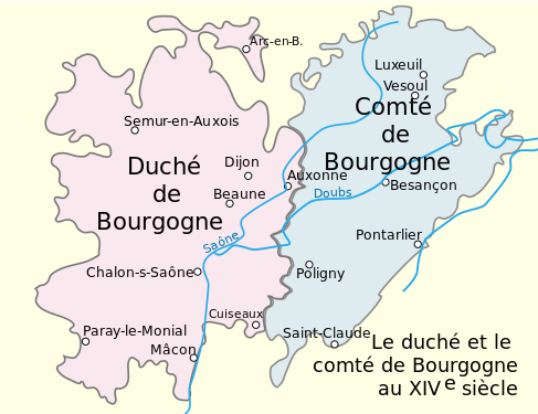
Duchy and County of Burgundy during the 15th century.


العصور الحديثة

Most of the area making up the region of Bourgogne-Franche-Comté used to belong to the former provinces of Burgundy and Franche-Comté, but it also includes a significant part of the former provinces of Nivernais (now Nièvre), Champagne (now the northern part of Yonne), Orléanais (now the southwestern part of Yonne), the Territoire de Belfort (the region of Alsace that remained French territory after 1871), and a small portion of Île-de-France (now the northwestern part of Yonne).
From 1941 to 1944 the regional prefecture of Vichy reunited Burgundy and Franche-Comté, as did the igamie of Dijon from 1948 to 1964. During the formation of the regions of France, Burgundy and Franche-Comté once again became two separate regions, first as public establishments in 1972, then as territorial collectivities in 1982.
On 14 April 2014, François Patriat and Marie-Guite Dufay (the presidents of Burgundy and Franche-Comté, respectively) announced in a press conference the desire for the reunification of the two regions, further to the declarations of Prime Minister Manuel Valls, who proposed a simplification of the administrative divisions of France.
On 2 June 2014 a map presented by President François Hollande showed the two regions as one. These two regions were the only ones to have voluntarily discussed a merger, and their alliance was the only one not needing revision by the National Assembly or the Senate.
Acte III de la décentralisation officially adopted the merger of the two regions on 17 December 2014. It became effective on 1 January 2016.
جغرافيا
The region borders Grand Est to the north, Île-de-France to the northwest, Centre-Val de Loire to the west, Auvergne-Rhône-Alpes to the south and Switzerland (the cantons of Vaud, Neuchâtel and Jura) to the east.
The distances from Besançon, the capital of the region, to other cities are:[5]
- Paris, the national capital, 410 km (255 mi);
- Bordeaux, 729 km (453 mi);
- Toulouse, 762 km (473 mi);
- Marseille, 538 km (334 mi);
- Lyon, 227 km (141 mi);
- Montpellier, 523 km (325 mi);
- Nice, 694 km (431 mi).
الاقسام
Bourgogne-Franche-Comté comprises eight departments: Côte-d'Or, Doubs, Jura, Nièvre, Haute-Saône, Saône-et-Loire, Yonne, Territoire de Belfort.
المدن الرئيسية
- Dijon (151,212; headquarters regional prefecture)
- Besançon (116,914; headquarters regional council)
- Belfort (50,078)
- Chalon-sur-Saône (44,985)
- Nevers (36,762)
- Auxerre (34,869)
- Mâcon (33,865)


.JPG&filetimestamp=20200620210237&)
الاقتصاد
بلغ الناتج المحلي الإجمالي (الناتج المحلي الإجمالي) للمنطقة 75.6 مليار يورو في 2018 ، وهو ما يمثل 3.2٪ من الناتج الاقتصادي الفرنسي. بلغ نصيب الفرد من الناتج المحلي الإجمالي المعدل للقوة الشرائية 24200 يورو أو 80 ٪ من متوسط الاتحاد الأوروبي 27 في نفس العام كان الناتج المحلي الإجمالي لكل موظف 96٪ من متوسط الاتحاد الأوروبي.[6]
انظر أيضاً
المصادر
- ^ "La carte à 13 régions définitivement adoptée" [The 13-region map finally adopted]. Le Monde (in French). Agence France-Presse. 17 December 2014. Retrieved 13 January 2015.
{{cite news}}: CS1 maint: unrecognized language (link) - ^ "Comparateur de territoire: Région de Bourgogne-Franche-Comté (27)". Insee. Retrieved 11 September 2020.
- ^ قالب:Cite French law
- ^ قالب:Cite French decree
- ^ "Ville de Besançon". Annuaire-Mairie.fr (in French). Retrieved 13 June 2018.
{{cite web}}: CS1 maint: unrecognized language (link) - ^ "Regional GDP per capita ranged from 30% to 263% of the EU average in 2018". Eurostat.
{{cite web}}: CS1 maint: url-status (link)
وصلات خارجية
ألزاس • أكيتين • أوڤيرن • بورگونيه • بريتاني • سنتر • شامپين-أردين • كورسيكا • فرانش-كومته • إل دي فرانس • لانگدوك-روسيون • ليموزان • لورين • ميدي-پيريني • أراضي كاليه الشمالية • نورمندي السفلى • نورمندي العليا • بلاد اللوار • پيكاردي • پواتو-شارنت • پروڤنس-ألپ-كوت دازور • رون-ألپ مناطق وراء البحار: گويانا الفرنسية • گوادلوپ • مارتينيك • ريونيون |