مقاطعة وستشستر، نيويورك
| مقاطعة وستشستر، نيويورك (Westchester County, New York) | |||
| مقاطعة في ولاية نيويورك | |||
 باتجاه عقارب الساعة من أعلى: تاپان زي والجسر البديل؛ ميناء مامارونك؛ فليپسبورگ مانور؛ وسط مدينة وايت پلينز؛ وسط مدينة سكارسديل؛ متاجر في كاتوناه؛ سد نيو كرتون؛ ميدان گتي في يونكرز.
| |||
|
|||
| سميتً على اسم: تشستر، إنگلترة | |||
| البلد | الولايات المتحدة | ||
|---|---|---|---|
| State | نيويورك | ||
| المنطقة | وادي هدسون | ||
| نهر | هدسون | ||
| أوطى نقطة | مستوى سطح البحر (عند نهر هدسون وعلى لونگ آيلاند ساوند) | ||
| - المنسوب | 0 ft (0 m) | ||
| المساحة | 500 sq mi (1،295 km2) | ||
| - الأرض | 430 sq mi (1،114 km2) | ||
| - water | 69 sq mi (179 km2) | ||
| التعداد | 974,542[1] (2016) | ||
| الكثافة | 876.5/km2 (2،270/sq mi) | ||
| تأسست | 1683 | ||
| المسئول التنفيذي | جورج لاتيمر (د) | ||
| Timezone | North American Eastern (EST) (UTC-5) | ||
| - summer (DST) | EDT (UTC-4) | ||
| الرمز البريدي | 105xx-108xx[nb 1] | ||
| Area code | 914 | ||
| دوائر الكونگرس | 16، 17، 18 | ||
| مقعد المقاطعة | وايت پلينز | ||
| أكبر مدينة | يونكرز | ||
| رمز FIPS | 36-119 | ||
| GNIS feature ID | 974157 | ||
| Demonym | Westchesterite[3][4] | ||
 موقع مقاطعة وستشستر في ولاية نيويورك.
| |||
| Wikimedia Commons: Westchester County, New York | |||
| الموقع: www3 | |||


مقاطعة وستشستر Westchester County هي مقاطعة في ولاية نيويورك الأمريكية. وهي ثاني أكثر المقاطعات المكتظة بالسكان على البر الرئيسي لنيويورك، بعد برونكس.[5] حسب تعداد 2010، كان عدد سكان المقاطعة 949.113 نسمة، وبحلول 2016 قدرت الزيادة بنسبة 2.7% ليصل عدد السكان إلى 974.542.[1] تقع المقاطعة في وادي هدسون، وتغطي مساحة 1.200 كم²، وتتألف من 6 مدن، 19 بلدة، و23 قرية. تأسست عام 1683، وسُميت على اسم مدينة تشستر، إنگلترة.[6][7] يقع مقعد المقاطعة في مدينة وايت پلينز، بينما أكثر البلديات اكتظاظاً بالسكان في المقاطعة هي مدينة يونكرز، بتعداد سكان بلغ 200.807 نسمة في 2016.[8]
الدخل السنوي للفرد في وستشستر عام 2011 كان 67.813 دولار. عام 2011، كان دخل الأسرة المتوسطة 77.006 دولار، خامس أكبر دخل في نيويورك (بعد مقاطعات ناسو، پوتنام، سفك، وروكلاند) وتحتل الترتيب 47 على مستوى الولايات المتحدة.[9] بحلول 2014، ارتفع دخل الأسرة المتوسطة في المقاطعة إلى 83.422.[10] احتلت مقاطعة وستشستر الترتيب الثاني في الولايات بعد مقاطعة نيويورك من حيث الدخل المتوسط للفرد، حيث أعلى تركيز للدخل في الأسر الصغيرة. في الوقت ذاته، عام 2013، كانت الضرائب العقارية في مقاطعة وستششستر أعلى من أي مقاطعة بالولايات المتحدة.[11]
مقاطعة وستشستر هي إخدى المقاطعات الواقعة في وسط منطقة نيويورك الحضرية. تتقاطع المقاطعة مع مدينة نيويورك، مقاطعتي ناسو وسفك على لونگ آيلاند، وتحدها من الجنوب لونگ آيلاند ساوند، ومن الشمال مقاطعة پونتام؛ ومن الشرق مقاطعة فيرفيلد، كنتيكت؛ ومقاطعة روكلاند ومقاطعة برگن، نيوجرزي عبر نهر هدسون من الغرب. كانت وستشستر أول ضاحية يتم تطويرها في العالم بهذا الحجم، ويرجع هذا بشكل أساسي لتطوير الطبقة العليا-المتوسطة للمجتمع بأكمله في أواخر القرن التاسع عشر والنمو السكاني السريع اللاحق.[12] بسبب طرقها المتعددة ووصلات المواصلات العامة لمدينة نيويورك، فضلاً عن الحدود التي تتشاركها مقاطعة وستشستر مع برونك، فقد شهد القرن 20 و21 المزيد من التطوير، خاصة المنطقة الجنوبية، التي تطورت بشكل بنفس الكثافة التي شهدتها مدينة نيويورك نفسها.
التاريخ
في زمن الاتصال الأوروپي في القرن 16 و17، كان السكان الأمريكان الأصليون في مقاطعة وستشستر الحالية جزءاً من شعوب الألگونكويان، الذين كانوا يطلقون على أنفسهم لناپ، ويعني الشعب. أطلقوا على المنطقة اسم لناپهوكينگ، والتي كانت تتكون من المنطقة المحيطة والمجاورة لنهري ديلاوير وهدسون. استطونت المنطقة قبائل مختلفة، منها جماعات المنهاتن، الوكواسگيك والسيوانوي من الواپينگر في الجنوب، التناكيتك، السينتسينك والكيتشوانك واپينگر في الشمال.
الاقتصاد
لقربها من مدينة نيويورك، الكثير من شركات فورتشن 500 لديها مقرات [13] في مقاطعة وستشستر، منها:
- ماستركارد في پرشاس، نيويورك، پرشاس
- پپسيكو، في پرشاس، نيويورك، پرشاس
- آي بي إم، في أرمونك
- شركة أي تي تي، في وايت پلينز
- جاردن، في راي
- يونيڤرسال أمريكان في وايت پلينز
- ريجنرون، في تاريتاون
التقنية المتقدمة
تك ڤالي هو اسم تسويقي للمنطقة الشرقية من ولاية نيويورك، ويشمل هدسون ڤالي وكاپيتال دستركت.[14] نشأ المصطلح عام 1998 للترويج لمنطقة ألباني الكبرى كمنافس لمناطق مثل سليكون ڤالي وبوسطن، ومنذ ذلك الحين حتى وقتنا نمت المنطقة لتمثل المقاطعات في نيويورك بين مصانع أي بي إم في مقاطعة وستشستر في الجنوب والحدود الكندية-الأمريكية في الشمال.
التكنولوجيا الحيوية
كما طورت مقاطعة وستشستر قطاع التكنولوجيا الحيوية المزدهر في القرن 21، باستثمارات خاصة وصلت قيمتها في 2016 لأكثر من بليون دولار،[15] مما دع مجلة وستشستر أن تطلق على المقاطعة لقب بويتشستر.[16] في أبريل 2017، أعلن مسئولي المقاطعة عن خطط لإنشاء مركز تكنولوجيا حيوية على مساحة 80 فدان، 3 مليون قدم مربع ليتم بناؤه بتكلفة 1.2 بليون دولار باستثمارات خاصة على أرض شاغرة مجاورة لمركز وستشستر الطبي في ڤالهالا؛ مركز العلوم الحيوية، شراكة خاصة-حكومية، تهدف لخلق 12.000 فرصة عمل وتشمل على فضاء أبحاث للتكنولوجيا الحيوية يزيد عن 2.25 مليون قدم.[17][18]
الحكم

حكومة مقاطعة وستشستر تخضع لرئاسة المسئول التنفيذي للمقاطعة، الديمقراطي جورج لاتيمر. المدعي العام للمقاطعة هو أنطوني سكارپينو، و county clerk هو تيموثي إدوني.
السياسة
| السنة | الجمهوريون | الديمقراطيون | الأحزاب الثالثة |
|---|---|---|---|
| 2016 | 31.2% 131,238 | 64.9% 272,926 | 3.9% 16,491 |
| 2012 | 36.8% 143,122 | 62.0% 240,785 | 1.2% 4,540 |
| 2008 | 35.8% 147,824 | 63.4% 261,810 | 0.8% 3,410 |
| 2004 | 40.3% 159,628 | 58.1% 229,849 | 1.6% 6,293 |
| 2000 | 37.5% 139,278 | 58.6% 218,010 | 3.9% 14,525 |
| 1996 | 35.9% 123,719 | 56.9% 196,310 | 7.2% 24,834 |
| 1992 | 40.1% 151,990 | 48.7% 184,300 | 11.2% 42,550 |
| 1988 | 53.4% 197,956 | 45.8% 169,860 | 0.9% 3,192 |
| 1984 | 58.7% 229,005 | 41.1% 160,225 | 0.3% 1,078 |
| 1980 | 54.4% 198,552 | 35.6% 130,136 | 10.0% 36,461 |
| 1976 | 54.3% 208,527 | 45.1% 173,153 | 0.7% 2,616 |
| 1972 | 62.8% 262,901 | 36.9% 154,412 | 0.3% 1,122 |
| 1968 | 50.3% 201,652 | 43.4% 173,954 | 6.3% 25,201 |
| 1964 | 37.9% 149,052 | 62.0% 243,723 | 0.1% 460 |
| 1960 | 56.6% 224,562 | 43.2% 171,410 | 0.2% 691 |
| 1956 | 72.2% 271,906 | 27.8% 104,857 | 0.0% 0 |
| 1952 | 67.4% 237,105 | 32.2% 113,358 | 0.4% 1,454 |
| 1948 | 60.9% 177,077 | 32.9% 95,681 | 6.1% 17,853 |
| 1944 | 61.7% 174,635 | 38.0% 107,591 | 0.3% 756 |
| 1940 | 62.3% 182,883 | 37.5% 110,114 | 0.2% 694 |
| 1936 | 51.1% 133,670 | 47.2% 123,561 | 1.7% 4,338 |
| 1932 | 51.1% 112,747 | 45.9% 101,435 | 3.0% 6,606 |
| 1928 | 56.2% 109,939 | 41.4% 80,926 | 2.4% 4,679 |
| 1924 | 63.9% 85,029 | 23.3% 30,964 | 12.8% 17,042 |
| 1920 | 68.3% 76,020 | 25.2% 28,060 | 6.5% 7,255 |
| 1916 | 59.4% 34,693 | 38.5% 22,457 | 2.1% 1,230 |
| 1912 | 29.5% 15,843 | 39.4% 21,160 | 31.1% 16,708 |
| 1908 | 58.4% 29,438 | 36.4% 18,346 | 5.2% 2,638 |
| 1904 | 55.9% 25,101 | 40.3% 18,093 | 3.8% 1,685 |
| 1900 | 54.9% 21,256 | 42.5% 16,439 | 2.7% 1,032 |
| 1896 | 59.6% 19,337 | 36.2% 11,752 | 4.2% 1,345 |
| 1892 | 43.2% 13,456 | 51.7% 16,088 | 5.1% 1,595 |
| 1888 | 46.8% 13,799 | 50.7% 14,948 | 2.5% 732 |
| 1884 | 46.1% 11,286 | 51.1% 12,525 | 2.8% 683 |
| تسجيل الناخبين، 1 أبريل 2016[20] | |||||
|---|---|---|---|---|---|
| الحزب | الناخبون النشطون | الناخبون الغير نشطون | إجمالي الناخبين | النسبة المئوية | |
| الديمقراطي | 263,855 | 26,561 | 290,416 | 47.65% | |
| الجمهوري | 128,152 | 12,200 | 140,352 | 23.02% | |
| لا حزبي | 129,709 | 14,297 | 144,006 | 23.62% | |
| أخرى [nb 2] | 31,460 | 3,348 | 34,808 | 5.71% | |
| الإجمالي | 553,176 | 56,406 | 609,582 | 100% | |
التجمعات
.png)
Westchester County has six cities, 19 towns, and 23 villages.
Cities in Westchester have many well established sub-areas within the municipal boundaries. Many of these are similar to hamlets and date back to as early as the late 1600s such as Cooper's Corners in New Rochelle. These areas also include some of the first planned communities in the country such as New Rochelle's Residence Park, Rochelle Park and Heights and Sutton Manor.
المدن الست في المقاطعة هي:[21]
| City | Population | Area (mi2) | Density (Pop. per mi2) |
Founded/first incorporated |
Notes |
|---|---|---|---|---|---|
| Yonkers | 211,569 | 20.3 | 11,749.9 | 1646 / 1854 | 3rd most populated city in New York State |
| New Rochelle | 79,726 | 13.2 | 7,750.9 | 1688 / 1899 | 7th most populated city in New York State |
| Mount Vernon | 73,893 | 4.4 | 16,824.5 | 1664 / 1853 | 8th most populated city in New York State |
| White Plains | 59,559 | 9.9 | 6,116.8 | 1721 | 11th most populated city in New York State, also Westchester county seat |
| Peekskill | 25,431 | 5.5 | 5,854.3 | 1684 / 1816 | 29th most populated city in New York State |
| Rye | 16,592 | 20.0 | 2,834.9 | 1660 / 1904 | 37th most populated city in New York State, also the name of a town |
Any land area in the county that is not contained in one of the cities is in a town. A town may have from zero to multiple villages. The largest city in the county by population is Yonkers with over 211,000 residents. The city with the highest population density is Mount Vernon with a density of 16,824 individuals per square mile.[22][23]
The towns of Harrison, Mount Kisco, and Scarsdale are coterminous with the villages of the same names. Two villages are split between two towns: Briarcliff Manor crosses the border between Ossining town and Mount Pleasant, and Mamaroneck village straddles the boundary between Mamaroneck town and Rye town.
With the exception of the towns of Rye, Pelham, Harrison, Mount Kisco, and Scarsdale, all the towns contain area and residents which do not belong to any village. These areas may contain communities referred to as hamlets, or "unincorporated areas". Hamlets have no legal status and depend upon the town for all municipal government and services. There are also areas called census-designated places (CDPs), which are defined by the U.S. Census Bureau for statistical purposes only. A CDP may or may not correspond to a hamlet.
Because some municipalities have the same name, it is often necessary to indicate whether one is referring to the city, town, village, or hamlet. For example, the town of Rye is completely separate from the city of Rye. Pelham is the name of a town and also of a village in the town. The village of Mamaroneck is located partially in the town of Mamaroneck and partially in the town of Rye, but has nothing to do with the city of Rye.
ZIP Codes in Westchester often are not coterminous with the actual municipality borders, causing mailing addresses to sometimes differ from the actual municipal location in which a property resides. For instance, the ZIP Codes for Bronxville, Larchmont, Rye, and Scarsdale contain large areas that lie outside of those municipalities.
All of the towns have justice courts, and some of the villages do as well.
The towns are listed as follows:[21]
- Town
- Villages (if any), one per bullet
- CDPs (if any), all listed on a single bullet
- Communities not in a village or CDP (if any), all listed on a single bullet
- (The list of towns, villages, and CDPs is complete. The listing of additional communities should not be considered complete.)
- Bedford, containing no villages:
- (contains the CDPs of Bedford, Bedford Hills and Katonah)
- (plus additional area belonging to no CDP)
- Cortlandt, containing two villages:
- Buchanan
- Croton-on-Hudson
- (contains the CDPs of Crugers, Montrose and Verplanck)
- (plus additional area belonging to no village or CDP, including the community of Cortlandt Manor)
- Eastchester, containing two villages:
- Bronxville
- Tuckahoe
- (contains the CDP of Eastchester, which encompasses all area outside the villages)
- Greenburgh, containing six villages:
- Ardsley
- Dobbs Ferry
- Elmsford
- Hastings-on-Hudson
- Irvington
- Tarrytown
- (contains the CDPs of Fairview, Greenville and Hartsdale)
- (plus additional area belonging to no village or CDP)
- Harrison, coterminous with the village of the same name (includes the communities of Purchase and West Harrison)
- Lewisboro, containing no villages:
- (contains the CDP of Goldens Bridge)
- (plus additional area belonging to no CDP, including the communities of Cross River, Lewisboro, South Salem, Vista and Waccabuc)
- Mamaroneck, containing two villages:
- Larchmont
- Mamaroneck (shared with the Town of Rye)
- (plus additional area belonging to no village (or CDP))
- Mount Kisco, coterminous with village of same name
- Mount Pleasant, containing three villages:
- Briarcliff Manor (This village is shared with the Town of Ossining.)
- Pleasantville
- Sleepy Hollow (formerly named North Tarrytown)
- (contains the CDPs of Hawthorne, Thornwood and Valhalla)
- (plus additional area belonging to no village or CDP, including the community of Pocantico Hills)
- New Castle, containing no villages:
- North Castle, containing no villages:
- (contains the CDP of Armonk)
- (plus additional area belonging to no CDP, including the communities of Banksville and North White Plains)
- North Salem, containing no villages:
- (contains the portion of the CDP of Peach Lake that is not in Putnam County)
- (plus additional area belonging to no CDP, including the communities of Croton Falls, Purdys and Salem Center)
- Ossining, containing two villages:
- Briarcliff Manor (This village is shared with the Town of Mount Pleasant.)
- Ossining (The village of Ossining is contained within the Town of Ossining.)
- (plus additional area belonging to no village or CDP, including the community of Crotonville)
- Pelham, containing two villages:
- Pelham (The Village of Pelham is contained within the Town of Pelham.)
- Pelham Manor
- (The villages cover the entire area of the town.)
- (The village of North Pelham existed from 1896 to 1975, when it was merged into the village of Pelham.)
- Pound Ridge, containing no villages:
- (contains the CDP of Scotts Corners)
- (plus additional area belonging to no CDP, including the community of Pound Ridge)
- Town of Rye (Rye is also the name of a city.), containing three villages:
- Mamaroneck (This village is shared with the Town of Mamaroneck. The portion in Rye is unofficially also called "Rye Neck". The city of Rye separates Mamaroneck from the rest of the town of Rye.)
- Port Chester
- Rye Brook (Prior to 1982, Rye Brook was the unincorporated area of the Town of Rye, and still shares the same ZIP Code as Port Chester.)
- (The villages cover the entire area of the town.)
- Scarsdale, coterminous with village of same name
- Somers, containing no villages:
- (contains the CDPs of Heritage Hills, Lincolndale and Shenorock)
- (plus additional area belonging to no CDP, including the communities of Amawalk, Baldwin Place, Granite Springs, and Somers)
- Yorktown, containing no villages:
- (contains the CDPs of Crompond, Jefferson Valley-Yorktown, Lake Mohegan, Shrub Oak and Yorktown Heights)
- (plus additional area belonging to no CDP, including the community of Kitchawan)
انظر أيضاً
- التنوع الحيوي في مقاطعة وستشستر، نيويورك
- قائمة مقاطعات نيويورك
- مدرجات السجل الوطني للأماكن التاريخية في مقاطعة وستشستر، نيويورك
- يوإسإس وستشستر كاونتي (إلإستي-1167)
- Downstate New York
- Southern Westchester
- Thomas Cacciopoli
الهوامش
- ^ The full set is as follows: 10501-10507, 10509-10511, 10514, 10517-10523, 10526-10528, 10530, 10532-10533, 10535-10536, 10538, 10540, 10543, 10545-10550, 10552-10553, 10560, 10562, 10566-10567, 10570, 10573, 10576-10578, 10580, 10583, 10587-10591, 10594-10598, 10601, 10603-10607, 10701, 10703-10710, 10801, 10803-10805.[2]
- ^ لا يشمل الناخبون المنتمون الحزب المحافظ، حزب الخضر، حزب الأسر العاملة، الحزب المستقل، حزب مساواة المرأة، وأحزاب أخرى صغيرة.
المصادر
- ^ أ ب "State & County QuickFacts - Westchester County, New York". United States Census Bureau. Retrieved August 31, 2017.
- ^ "Mapping Westchester County" (Map). Westchester County Geographic Information Systems. Westchester County. Retrieved September 3, 2014.
{{cite map}}: Unknown parameter|mapurl=ignored (|map-url=suggested) (help) - ^ http://www.nystateofpolitics.com/2015/06/astorino-welcomes-second-westchesterite-to-presidential-race/ Accessed April 23, 2016.
- ^ http://www.westchestermagazine.com/Westchester-Magazine/July-2012/Editors-Memo-July-2012-What-It-Means-to-Be-a-Westchesterite/ Accessed April 23, 2016.
- ^ خطأ استشهاد: وسم
<ref>غير صحيح؛ لا نص تم توفيره للمراجع المسماة100ff - ^ "Westchester". Encyclopædia Britannica. Encyclopædia Britannica, Inc. 2013. Retrieved September 2, 2014.
- ^ Aiken, Charles Curry; Kane, Joseph Nathan (2013). The American Counties: Origins of County Names, Dates of Creation, Area, and Population Data, 1950-2010 (6th ed.). Lanham, Maryland: Scarecrow Press, Inc. p. 326. ISBN 978-0-8108-8761-9. OCLC 809988969. Retrieved September 3, 2014.
- ^ "Annual Estimates of the Resident Population: April 1, 2010 to July 1, 2016 Population Estimates Yonkers city, New York". United States Census Bureau. Retrieved September 8, 2017.
- ^ "Highest income counties in 2011". Washington Post. September 20, 2012. Retrieved August 26, 2014.
- ^ "QuickFacts Westchester County, New York". United ونتا Census Bureau. Retrieved April 24, 2016.
- ^ خطأ استشهاد: وسم
<ref>غير صحيح؛ لا نص تم توفيره للمراجع المسماةhigh tax - ^ Westchester: The American Suburb, Robert Pannetta;foreword, vii
- ^ "Business in the Burbs". Retrieved April 23, 2017.
- ^ "About Tech Valley". Tech Valley Chamber Coalition. Archived from the original on نوفمبر 3, 2008. Retrieved سبتمبر 27, 2009.
{{cite web}}: Unknown parameter|deadurl=ignored (|url-status=suggested) (help) - ^ John Jordan (January 2016). "$1.2 Billion Project Could Make Westchester a Biotech Destination". Hudson Gateway Association of Realtors. Retrieved April 9, 2016.
- ^ Steve Ditlea. "Westchester's Unexpected Powerhouse Position In the Biotech Industry - Four years after our initial look at Westchester's biotech industry, the sector has gone from fledgling to behemoth". Today Media. Retrieved April 7, 2016.
All around, there are signs of a Biochester bloom:
- ^ "$1.2B Westchester Biotech Center Deal Will Create 12K Jobs, Officials Say". White Plains Daily Voice. April 3, 2017. Retrieved April 3, 2017.
- ^ Richard Liebson (April 3, 2017). "Biotech research: Massive Valhalla center forges ahead". LoHud the Journal News - part of the USA TODAY network. Retrieved April 3, 2017.
- ^ http://uselectionatlas.org/RESULTS
- ^ "NYSVoter Enrollment by County, Party Affiliation and Status" (PDF). New York State Board of Elections. أبريل 2016. Archived from the original (PDF) on يوليو 30, 2016. Retrieved يوليو 30, 2016.
{{cite web}}: Unknown parameter|deadurl=ignored (|url-status=suggested) (help) - ^ أ ب "American Community Survey Municipal Profiles". Westchester County Government: Department of Planning. December 4, 2012.
- ^ "American Community Survey Municipal Profiles". Westchester County Government: Department of Planning. December 4, 2012.
- ^ "Westchester County Municipal Profiles" (PDF). Westchester County Department of Planning. Archived (PDF) from the original on February 1, 2017.
خطأ استشهاد: الوسم <ref> ذو الاسم "GR1" المُعرّف في <references> غير مستخدم في النص السابق.
خطأ استشهاد: الوسم <ref> ذو الاسم "RiverWalk" المُعرّف في <references> غير مستخدم في النص السابق.
خطأ استشهاد: الوسم <ref> ذو الاسم "Auto3Z-2" المُعرّف في <references> غير مستخدم في النص السابق.
خطأ استشهاد: الوسم <ref> ذو الاسم "Decennial" المُعرّف في <references> غير مستخدم في النص السابق.
خطأ استشهاد: الوسم <ref> ذو الاسم "UVA" المُعرّف في <references> غير مستخدم في النص السابق.
خطأ استشهاد: الوسم <ref> ذو الاسم "Forstall" المُعرّف في <references> غير مستخدم في النص السابق.
خطأ استشهاد: الوسم <ref> ذو الاسم "Census2000" المُعرّف في <references> غير مستخدم في النص السابق.
خطأ استشهاد: الوسم <ref> ذو الاسم "Auto3Z-4" المُعرّف في <references> غير مستخدم في النص السابق.
خطأ استشهاد: الوسم <ref> ذو الاسم "Auto3Z-5" المُعرّف في <references> غير مستخدم في النص السابق.
خطأ استشهاد: الوسم <ref> ذو الاسم "Auto3Z-6" المُعرّف في <references> غير مستخدم في النص السابق.
خطأ استشهاد: الوسم <ref> ذو الاسم "Auto3Z-7" المُعرّف في <references> غير مستخدم في النص السابق.
خطأ استشهاد: الوسم <ref> ذو الاسم "Auto3Z-8" المُعرّف في <references> غير مستخدم في النص السابق.
خطأ استشهاد: الوسم <ref> ذو الاسم "Auto3Z-9" المُعرّف في <references> غير مستخدم في النص السابق.
<ref> ذو الاسم "WestNHLs" المُعرّف في <references> غير مستخدم في النص السابق.قراءات إضافية
- Borkow, Richard (2011). George Washington's Westchester Gamble: The Encampment on the Hudson and the Trapping of Cornwallis. Charleston, SC: History Press. ISBN 978-1609490393.
- Williams, Gray (2003). Picturing Our Past: National Register Sites in Westchester County. Westchester County Historical Society. ISBN 0-915585-14-6.
وصلات خارجية
| Find more about Westchester County at Wikipedia's sister projects | |
| Media from Commons | |
| Travel guide from Wikivoyage | |
| Database entry Q54066 on Wikidata | |
- Westchester County Government
- The Westchester County Department of Public Safety
- Westchester County at the Open Directory Project
- Hudson Valley Directory, listings pertaining to Westchester County, New York

بلديات ومجتمعات مقاطعة وستشستر، نيويورك، الولايات المتحدة | ||
|---|---|---|
| المدن | 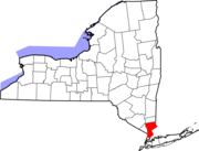 | |
| البلدات | ||
| القرى | ||
| أماكن تعداد | ||
| قرى أخرى | ||
| الهوامش | ‡هذا المكان المأهول لديه مناطق في مقاطعة أو مقاطعات مجاورة | |
| المقاطعات |  | |
|---|---|---|
| المدينة الرئيسية | ||
| المدن والبلدات 100–999 ألف | ||
| المدن والبلدات 25–99 ألف | بايون • برانفورد • Cheshire • كلفتن • دانبري • إيست هاڤن • إيست اورانج • إنگلوود • فيرفيلد • گارفيلد • گرينتش • هاكنساك • هامدن • هوبوكن • هاول • كارني • لونگ بيتش • لونگ برانش • مريدن • مدلتاون • ملفورد • ماونت ڤرنون • نوگاتك • نيو برنزويك • نيو ملفورد • نيو روشل • نيوبرگ • نيوتن • نورواك • پاسيك • پرث أمبوي • پلينفيلد • پوكپسي • راوِيْ • شلتن • ستراتفورد • Torrington • ترنتون • ترمبول • يونيون سيتي • Wallingford • وست هيڤن • وستفيلد • وستپورت • هوايت پلينز | |
| المدن والبلدات 10–25 ألف | أنسونيا • آسبري پارك • بيكن • بثل • بروكفيلد • دارين • دربي • دوڤر • گلفورد • گوتنبرگ • هاريسن (نيو جرزي) • هاريسن (نيويورك) • كنگستن • ليندن • ماديسون • منرو • موريستاون • نيو كينن • New Fairfield • North Branford • North Haven • اورانج • پليموث • پيكسكيل • Ridgefield • راي • سكارسديل • سكوكس • سيمور • ساوثبري • سمت • واترتاون • وست نيويورك • وستن • ولتن • ونشستر • وولكت | |
| المناطق الفرعية | ||
- CS1 errors: unsupported parameter
- Pages using geobox2 unit with unknown unit type
- Geobox usage tracking for settlement type
- Articles with hatnote templates targeting a nonexistent page
- مقاطعة وستشستر، نيويورك
- مقاطعات منطقة نيويورك الحضرية
- لونگ آيلاند ساوند
- عائلة روكفلر
- تأسيسات 1683 في نيويورك
- أماكن مأهولة تأسست في 1683
- مقاطعات ولاية نيويورك