كفار طابور
كفار طابور
Kfar Tavor | |
|---|---|
مجلس محلي (منذ 1949) | |
 ميدان الحارس في كفار طابور، من نحت: عساف ليفشيتس | |
 الشعار | |
 كفار طابور  كفار طابور | |
| الإحداثيات: 32°41′13″N 35°25′15″E / 32.68694°N 35.42083°E | |
| Grid position | 189/232 PAL |
| البلد | |
| المنطقة | الشمالية |
| تأسست | 1901 |
| الحكومة | |
| • Head of Municipality | Oded Halperin |
| المساحة | |
| • الإجمالي | 1٬231 dunams (1٫231 كم² or 304 acres) |
| التعداد (2019)[1] | |
| • الإجمالي | 4٬311 |
| • الكثافة | 3٬500/km2 (9٬100/sq mi) |
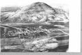
كفار طابور (بالعبرية: כְּפַר תָּבוֹר، Kfar Tavor ) هي قرية في الجليل الأسفل في منطقة شمال إسرائيل، على سفح جبل طابور. تأسست في 1901، وحصلت على وضع مجلس محلي في 1949. في 2019 بلغ تعدادها 4,311. وفي 2017، تقريباً كل سكانها كانوا يهوداً.[2]
التاريخ
Ceramics from the Byzantine era have been found here.[3]
في مطلع القرن التاسع، في العصر العباسي، ترك أبو صالح خير الخادم، خصي الخليفة المعتز بالله، كل أملاكه في كفار طابور (التي كان اسمها آنذاك كفر طبرية) وفي قرية أخرى بالجليل، كفر كنا، كوقف. The endowments were supposed to be eternal, but were presumably ended by the conquest of the Crusaders in 1099.[4][5][6]
العصر العثماني
القرية العربية
In the Ottoman era there was a village here called Mes'ha.[7] In 1596 the village appeared under the name of "Masha" in the tax registers كجزء من ناحية طبرية في سنجق صفد. It was noted as "hali"(=empty), but a fixed tax-rate of 25% on agricultural product was paid. These products included wheat, barley and cotton; the taxes totalled 3,300 akçe.[8] In 1799 it appeared as Mechi on the map Pierre Jacotin compiled that year.[9]
In 1881, the Palestine Exploration Fund's Survey of Western Palestine described "Meshah" village with a population of 100 Muslims, with houses chiefly of basalt stone, and a few of adobe and stone. The village was situated on an arable plain, without trees. The water supply was from a cistern in the village.[10]
القرية اليهودية
تأسست كفار تاڤور في 1901 على يد رواد من First Aliya تحت إشراف جمعية الاستعمار اليهودي.[11] Twenty-eight farmers settled in the area with the assistance of the philanthropist Baron Edmond de Rothschild. The new settlement was originally known as Mes'ha, the name of the nearby Arab village.[12] It was renamed in 1903 at the urging of Zionist leader Menachem Ussishkin who visited the site and was surprised to find it had no Hebrew name.[13] At first, there was some debate over whether to use the term kfar ("village"), which some residents thought would bode badly for future growth. Ussishkin responded that he had visited the German town of Düsseldorf, which had also originated as a Dorf, or village, but was now a full-fledged city. The Rothschild administration determined that the site was ideal for cultivating grapes. The vineyards of Kfar Tavor became a supplier of grapes to the country's wineries.[بحاجة لمصدر]
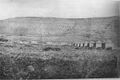
On 12 April 1909 a group of Bar Giora members left Sejera, were they had been based, and met in secret at Kfar Tavor. Led by Israel Shochat and Yitzhak Ben-Zvi it was decided to establish an armed militia - Hashomer. Its members were to act as guards for Jewish colonies and work as laboured towards establishing further colonies.[14]
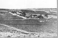
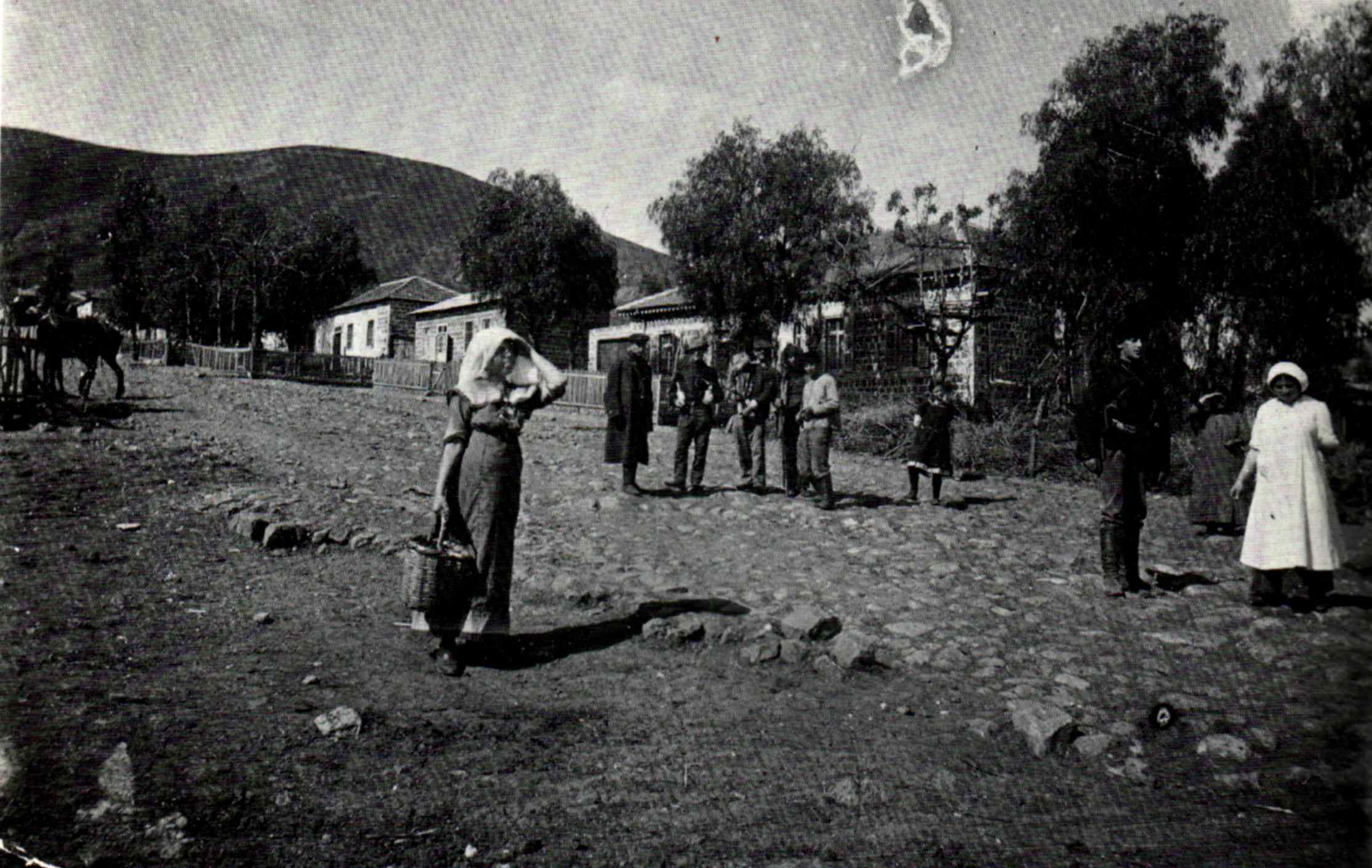
Kfar Tavor 1908
Kfar Tavor 1909
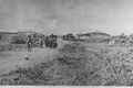
Kfar Tavor 1910
Kfar Tavor 1920
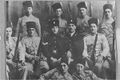
Kfar Tavor guards 1938


عصر الانتداب البريطاني

In the 1922 census of Palestine conducted by the British Mandate authorities, Mesha (Kufr Tabur) had a population of 274; all Jews.[15] The 1931 census of Palestine recorded 328 persons in Mas-ha living in 54 houses: 304 Jews, 20 Muslims and 4 Christians.[16]
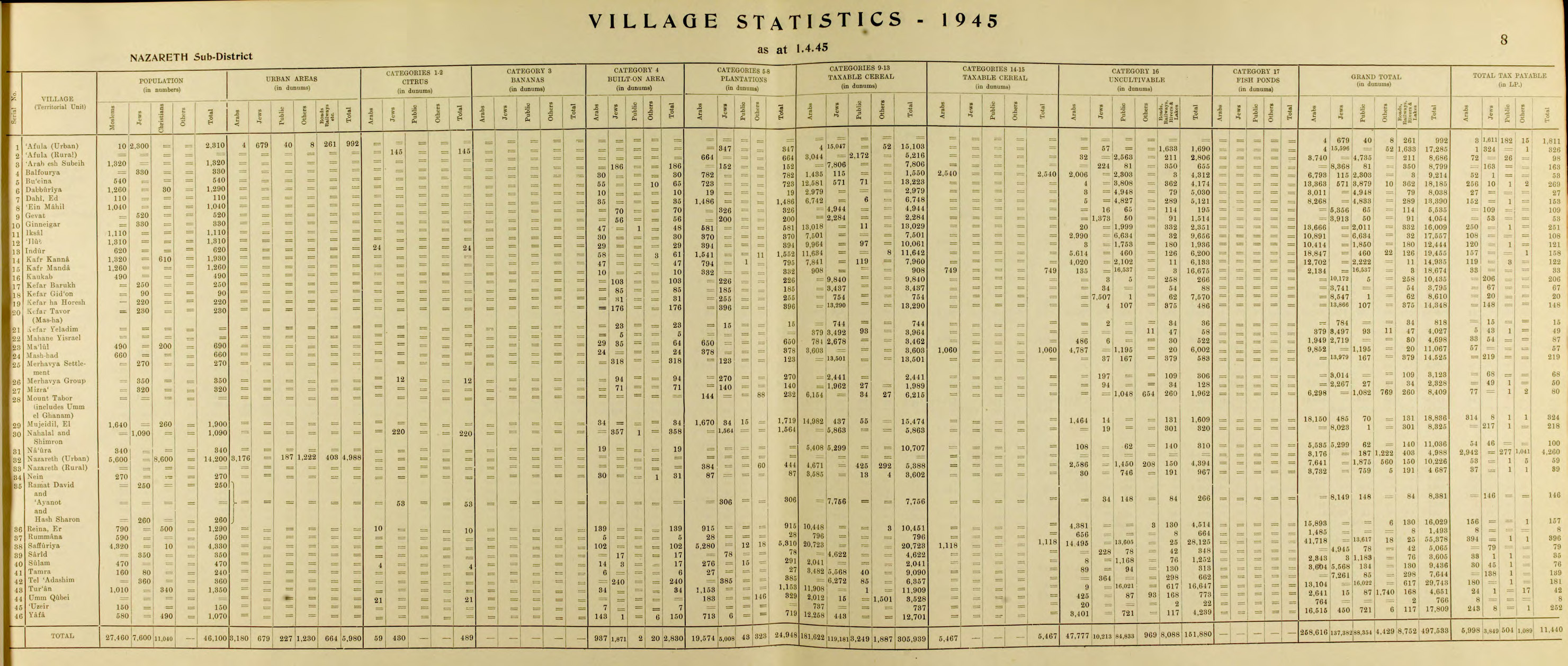
In the 1945 statistics Kfar Tavor had 230 inhabitants, all Jews. Mas-ha was noted as an alternative name.[17][18]
المعالم
In the Hameyasdim neighborhood, the core of the village, there is a museum and other sites, including the HaShomer house, the first school and teacher's house (now a library) and a synagogue that was built in 1937. Another school, built in 1911, now serves as the Shenkar Tzfira Music Center. The main street of the neighborhood has houses left from the village's early days, as well as parts of the wall that surrounded it.[13]
سكان بارزون

- إيگال آلون (1918–80)، السياسي وقائد الپالماخ، والجنرال في الجيش الإسرائيلي، وُلِد في كفار طابور.
- Micha Goldman (born 1948), politician, was born in Kfar Tavor
- Oz Blayzer (born 1992), basketball player
- Itay Segev (born 1995), basketball player
المراجع
- ^ "Population in the Localities 2019" (XLS). Israel Central Bureau of Statistics. Retrieved 16 August 2020.
- ^ https://www.cbs.gov.il/he/publications/doclib/2019/local_authorities17_1759/745_0047.pdf[bare URL PDF]
- ^ Dauphin, 1998, p. 730
- ^ Mehmet Tutuncu and Lotfi L Abdeljaouad, 2021, Earliest Islamic Waqf on stone
- ^ Earliest waqf legacy in the world is deciphered: Two villages in Palestine, Ruth Schuster, Dec. 5, 2021, Haaretz
- ^ The earliest known Waqf inscription in stone; a large and impressive calligraphic marble stele, Near East or Egypt, circa 880-900, 8 Oct 2015; Christie's
- ^ "The place of unction", according to Palmer, 1881, p. 131
- ^ Hütteroth and Abdulfattah, 1977, p. 187
- ^ Karmon, 1960, p. 167 Archived 2019-12-22 at the Wayback Machine
- ^ Conder and Kitchener, 1881, SWP I, p. 361
- ^ Ben-Porat, Amir (1991). "Immigration, proletarianization, and deproletarianization A case study of the Jewish working class in Palestine, 1882–1914". Theory and Society (20): 244.
- ^ Marom, Roy. "The Abu Hameds of Mulabbis: An Oral History of a Palestinian Village Depopulated in the Late Ottoman Period". British Journal of Middle Eastern Studies (in الإنجليزية). 48: 2.
- ^ أ ب "Our village - Kfar Tavor". Archived from the original on 2012-05-13. Retrieved 2009-08-20.
- ^ Segev, Tom (2018 - 2019 translation Haim Watzman) A State at Any Cost. The Life of David Ben-Gurion. Apollo. ISBN 9-781789-544633 p.96
- ^ Barron, 1923, Table XI, Sub-district of Tiberias, p. 39
- ^ E. Mills, ed. (1932). Census of Palestine 1931. Population of Villages, Towns and Administrative Areas. Jerusalem: Government of Palestine. p. 83.
- ^ Department of Statistics, 1945, p. 8
- ^ Government of Palestine, Department of Statistics. Village Statistics, April, 1945. Quoted in Hadawi, 1970, p. 62
ببليوجرافيا
- Barron, J.B., ed. (1923). Palestine: Report and General Abstracts of the Census of 1922. Government of Palestine.
- Conder, C.R.; Kitchener, H.H. (1881). The Survey of Western Palestine: Memoirs of the Topography, Orography, Hydrography, and Archaeology. Vol. 1. London: Committee of the Palestine Exploration Fund.
- Dauphin, C. (1998). La Palestine byzantine, Peuplement et Populations. BAR International Series 726 (in French). Vol. III : Catalogue. Oxford: Archeopress. ISBN 0-860549-05-4.
{{cite book}}: CS1 maint: unrecognized language (link) - Department of Statistics (1945). Village Statistics, April, 1945. Government of Palestine.
- Karmon, Y. (1960). "An Analysis of Jacotin's Map of Palestine" (PDF). Israel Exploration Journal. 10 (3, 4): 155–173, 244–253. Archived from the original (PDF) on 2019-12-22. Retrieved 2015-04-22.
- Hadawi, S. (1970). Village Statistics of 1945: A Classification of Land and Area ownership in Palestine. Palestine Liberation Organization Research Centre.
- Hütteroth, Wolf-Dieter; Abdulfattah, Kamal (1977). Historical Geography of Palestine, Transjordan and Southern Syria in the Late 16th Century. Erlanger Geographische Arbeiten, Sonderband 5. Erlangen, Germany: Vorstand der Fränkischen Geographischen Gesellschaft. ISBN 3-920405-41-2.
- Palmer, E.H. (1881). The Survey of Western Palestine: Arabic and English Name Lists Collected During the Survey by Lieutenants Conder and Kitchener, R. E. Transliterated and Explained by E.H. Palmer. Committee of the Palestine Exploration Fund.
وصلات خارجية
- Photo of Mes'ha (Kfar Tavor) from 1910
- Survey of Western Palestine, Map 6: IAA, Wikimedia commons
- Pages using gadget WikiMiniAtlas
- All articles with bare URLs for citations
- Articles with bare URLs for citations from March 2022
- Articles with PDF format bare URLs for citations
- Short description is different from Wikidata
- Articles containing عبرية-language text
- Articles containing explicitly cited عربية-language text
- Coordinates on Wikidata
- Pages using infobox settlement with missing country
- Articles with unsourced statements from November 2015
- مجالس محلية في المنطقة الشمالية (إسرائيل)
- أماكن مأهولة تأسست في 1901
- الجليل السفلي
- جبل طابور