كارسون سيتي، نيفادا
كارسن سيتي
Carson City | |
|---|---|
| البلدية المجمعة لكارسن سيتي | |
 Flag  الشعار | |
| الكنية: Carson, CC, The Capitol | |
| الشعار: Proud of its Past...Confident of its Future | |
 الموقع في نـِڤادا | |
 كارسن سيتي الموقع في الولايات المتحدة | |
| الإحداثيات: 39°9′39″N 119°45′14″W / 39.16083°N 119.75389°W | |
| البلد | الولايات المتحدة |
| الولاية | نـِڤادا |
| المقاطعة | None (Independent city) |
| Founded | 1858 |
| السمِيْ | كيت كارسون (رجل الجبال) |
| الحكومة | |
| • العمدة | لوري باگوِل (D) |
| • State Senator | Ben Kieckhefer (R) |
| • State Assemblyman | Al Kramer (R) |
| • U.S. Representative | Mark Amodei (R) |
| المساحة | |
| • الإجمالي | 157 ميل² (410 كم²) |
| • البر | 145 ميل² (380 كم²) |
| • الماء | 13 ميل² (30 كم²) 8.0% |
| المنسوب | 4٬802 ft (1٬463 m) |
| التعداد (2020) | |
| • الإجمالي | 58٬639 |
| • Estimate (2017)[1] | 54٬745 |
| • الكثافة | 370/sq mi (140/km2) |
| منطقة التوقيت | UTC−8 (Pacific) |
| • الصيف (التوقيت الصيفي) | UTC−7 (Pacific) |
| ZIP code | 89701-89706, 89711-89714, 89721 |
| مفتاح الهاتف | 775 |
| الموقع الإلكتروني | carson.org |
| الرقم المرجعي | 44 |
_at_Musser_Street_in_downtown_Carson_City,_Nevada.jpg&filetimestamp=20240415195833&)


.jpg&filetimestamp=20240415195821&)

كارسن سيتي (Carson City) هي عاصمة ولاية نـِڤادا الأمريكية. في عام 2005 قدر عدد سكانها بحوالي 57104 نسمة. كارسن سيتي هي الآن مدينة مستقلة، ليست جزء من أيّ مقاطعة. مثل العديد من المدن في نـِڤادا، كارسن سيتي تأسّست في أيام إزدهار التعدين. كمركز لتعدين الفضة، كانت كارسن سيتي حاضرة إقليم مقاطعة أورمسبي سابقاً، وقد سمّيت بهذا الاسم تيمناً بالمستكشف رجل الجبال كيت كارسون. The town began as a stopover for California-bound immigrants, but developed into a city with the Comstock Lode, a silver strike in the mountains to the northeast. The city has served as Nevada's capital since statehood in 1864; for much of its history it was a hub for the Virginia and Truckee Railroad, although the tracks were removed in 1950.
Before 1969, Carson City was the county seat of Ormsby County. That year the state legislature abolished the county and included its territory into a revised city charter for a Consolidated Municipality of Carson City.[2] With the consolidation, the city limits extend west across the Sierra Nevada to the California state line in the middle of Lake Tahoe. Like other independent cities in the United States, it is treated as a county-equivalent for census purposes.
تبلغ مساحة المدينة 403.2 كم2 (155.7 ميل مربع). أكبر المدن القريبة لكارسن سيتي هي رينو، التي تبعد عنها بحوالي 30 ميل شمالاً.
التاريخ


The Washoe people have inhabited the valley and surrounding areas for about 6,000 years.[3]
The first European Americans to arrive in what is now known as Eagle Valley were John C. Frémont and his exploration party in January 1843.[4] Fremont named the river flowing through the valley Carson River in honor of Kit Carson, the mountain man and scout he had hired for his expedition. Later, settlers named the area Washoe, in reference to the indigenous people.[5]
By 1851, the Eagle Station ranch along the Carson River was a trading post and stopover for travelers on the California Trail's Carson Branch, which ran through Eagle Valley. The valley and trading post received their name from a bald eagle that was hunted and killed by one of the early settlers and was featured on a wall inside the post.
As the area was part of the Utah Territory, it was governed from Salt Lake City, where the territorial government was headquartered. Early settlers bristled at the control by Mormon-influenced officials and desired the creation of the Nevada territory. A vigilante group of influential settlers, headed by Abraham Curry, sought a site for a capital city for the envisioned territory.[6] In 1858, Abraham Curry bought Eagle Station and the settlement was thereafter renamed Carson City.[7] Curry and several other partners had Eagle Valley surveyed for development. Curry decided Carson City would someday serve as the capital city and left a 10-acre (40،000 m2) plot in the center of town for a capitol building.
After gold and silver were discovered in 1859 on nearby Comstock Lode, Carson City's population began to grow. Curry built the Warm Springs Hotel a mile to the east of the city center. When territorial governor James W. Nye traveled to Nevada, he chose Carson City as the territorial capital, influenced by Carson City lawyer William Stewart, who escorted him from San Francisco to Nevada.[8] As such, Carson City bested Virginia City and American Flat. Curry loaned the Warm Springs Hotel to the territorial Legislature as a meeting hall. The Legislature named Carson City to be the seat of Ormsby County and selected the hotel as the territorial prison, with Curry serving as its first warden. Today, the property is still part of the state prison.
When Nevada became a state in 1864 during the American Civil War, Carson City was confirmed as Nevada's permanent capital. Carson City's development was no longer dependent on the mining industry and instead became a thriving commercial center. The Virginia and Truckee Railroad was built between Virginia City and Carson City. A log flume was also built from the Sierra Nevada into Carson City. The current capitol building was constructed from 1870 to 1871. The United States Mint operated the Carson City Mint between the years 1870 and 1893, which struck gold and silver coins. People came from China during that time, many to work on the railroad. Some of them owned businesses and taught school. By 1880, almost a thousand Chinese people, "one for every five Caucasians", lived in Carson City.[9]
Carson City's population and transportation traffic decreased when the Central Pacific Railroad built a line through Donner Pass, too far to the north to benefit Carson City. The city was slightly revitalized with the mining booms in Tonopah and Goldfield. The US federal building (now renamed the Paul Laxalt Building) was completed in 1890 as was the Stewart Indian School. Even these developments could not prevent the city's population from dropping to just over 1,500 people by 1930. Carson City resigned itself to small city status, advertising itself as "America's smallest capital". The city slowly grew after World War II; by 1960, it had reached its 1880 boom-time population.
20th-century revitalization and growth
As early as the late 1940s, discussions began about merging Ormsby County and Carson City. By this time, the county was little more than Carson City and a few hamlets to the west. However, the effort did not pay off until 1966, when a statewide referendum approved the merger. The required constitutional amendment was passed in 1968. On April 1, 1969, Ormsby County and Carson City officially merged as the Consolidated Municipality of Carson City.[2] With this consolidation, Carson City absorbed former town sites such as Empire City, which had grown up in the 1860s as a milling center along the Carson River and current U.S. Route 50. Carson City could now advertise itself as one of America's largest state capitals with its 146 ميل مربع (380 km2) of city limits.[10]
In 1991, the city adopted a downtown master plan, specifying no building within 500 أقدام (150 متر) of the capitol would surpass it in height. This plan effectively prohibited future high-rise development in the center of downtown.[11] The Ormsby House is the tallest building in downtown Carson City, at a height of 117 أقدام (36 m). The structure was completed in 1972.[12]
الجغرافيا
Most of the city proper resides in the Eagle Valley. The Carson River flows from Douglas County through the southwestern edge of both the valley and Carson City. Since the consolidation, the city limits today include several small populated areas outside of this valley. Today the city limits include several peaks in the Sierra Nevada, small portions of both the Virginia Range and the Pine Nut Mountains and portions of Marlette Lake and Lake Tahoe. The highest elevation in city limits is Snow Valley Peak at an elevation of 9،214 أقدام (2،808 m).[13] Carson City is one of two state capitals that border another state, the other being Trenton, New Jersey.
المناخ
_-_CARSON_CITY,_NV.svg&filetimestamp=20240415195753&)
Carson City features a cold semi-arid climate (Koppen: BSk) with cold winters and hot summers. The city is in a high desert river valley approximately 4،802 أقدام (1،464 m) above sea level. There are four fairly distinct seasons. Winters see typically light to moderate snowfall, with an average of 14.0 بوصات (36 cm). Most precipitation occurs in winter and spring, with summer and fall being fairly dry, drier than neighboring California. There are 39.5 days of 90 °F (32 °C)+ highs annually, with 100 °F (38 °C)+ temperatures occurring 1.2 days per year.[14]
The average temperature in Carson City increased by 4.1 °F (2.3 °C) between 1984 and 2014, a greater change than in any other city in the United States.[15]
| بيانات المناخ لـ Carson City, Nevada, 1991–2020 normals, extremes 1893–present | |||||||||||||
|---|---|---|---|---|---|---|---|---|---|---|---|---|---|
| الشهر | ينا | فب | مار | أبر | ماي | يون | يول | أغس | سبت | أكت | نوف | ديس | السنة |
| القصوى القياسية °ف (°س) | 72 (22) |
76 (24) |
81 (27) |
88 (31) |
94 (34) |
101 (38) |
107 (42) |
105 (41) |
103 (39) |
93 (34) |
79 (26) |
75 (24) |
107 (42) |
| متوسط القصوى اليومية °ف (°س) | 45.5 (7.5) |
49.5 (9.7) |
56.2 (13.4) |
61.7 (16.5) |
70.4 (21.3) |
80.9 (27.2) |
89.5 (31.9) |
87.8 (31.0) |
80.7 (27.1) |
68.0 (20.0) |
54.5 (12.5) |
44.6 (7.0) |
65.8 (18.8) |
| المتوسط اليومي °ف (°س) | 34.8 (1.6) |
38.3 (3.5) |
43.9 (6.6) |
48.8 (9.3) |
56.6 (13.7) |
65.0 (18.3) |
72.1 (22.3) |
70.2 (21.2) |
63.1 (17.3) |
52.2 (11.2) |
41.4 (5.2) |
34.2 (1.2) |
51.7 (10.9) |
| متوسط الدنيا اليومية °ف (°س) | 24.1 (−4.4) |
27.1 (−2.7) |
31.6 (−0.2) |
35.8 (2.1) |
42.9 (6.1) |
49.2 (9.6) |
54.8 (12.7) |
52.5 (11.4) |
45.6 (7.6) |
36.3 (2.4) |
28.4 (−2.0) |
23.9 (−4.5) |
37.7 (3.2) |
| متوسط الدنيا °ف (°س) | 6.9 (−13.9) |
11.7 (−11.3) |
17.4 (−8.1) |
22.3 (−5.4) |
29.7 (−1.3) |
35.8 (2.1) |
44.4 (6.9) |
42.1 (5.6) |
34.3 (1.3) |
21.8 (−5.7) |
11.4 (−11.4) |
6.2 (−14.3) |
0.6 (−17.4) |
| الصغرى القياسية °ف (°س) | −27 (−33) |
−22 (−30) |
−5 (−21) |
3 (−16) |
18 (−8) |
25 (−4) |
33 (1) |
26 (−3) |
17 (−8) |
6 (−14) |
−5 (−21) |
−26 (−32) |
−27 (−33) |
| متوسط تساقط الأمطار inches (mm) | 1.72 (44) |
1.48 (38) |
1.24 (31) |
0.51 (13) |
0.51 (13) |
0.37 (9.4) |
0.18 (4.6) |
0.14 (3.6) |
0.24 (6.1) |
0.55 (14) |
0.90 (23) |
1.50 (38) |
9.34 (237) |
| متوسط هطول الثلج inches (cm) | 3.6 (9.1) |
1.7 (4.3) |
1.6 (4.1) |
0.0 (0.0) |
0.0 (0.0) |
0.0 (0.0) |
0.0 (0.0) |
0.0 (0.0) |
0.0 (0.0) |
0.0 (0.0) |
0.7 (1.8) |
6.4 (16) |
14.0 (36) |
| Average precipitation days (≥ 0.01 in) | 6.2 | 5.6 | 4.8 | 3.2 | 3.4 | 1.7 | 0.9 | 1.0 | 1.1 | 2.4 | 3.3 | 4.8 | 38.4 |
| Source 1: NOAA[14] | |||||||||||||
| Source 2: National Weather Service[16] | |||||||||||||
Places of interest
Museums
- Nevada State Capitol – original capitol still housing the governor's offices with museum exhibits
- Nevada State Museum – former branch of the United States Mint featuring rock, mining and prehistoric exhibits, and a recreated Wild West village
- Nevada State Railroad Museum – featuring the Inyo locomotive and relocated Wabuska Railroad Station
- Stewart Indian School – museum collection includes items from former faculty, students and school[17]
- Foreman-Roberts House Museum[18] – Gothic Revival architecture, tours available.
- Sears–Ferris House[19] (not open to public) – home of George Washington Gale Ferris Jr., inventor of the Ferris wheel

- Yesterday's Flyers, an aviation museum in Carson City.[20]
- Children's Museum of Northern Nevada – Carson City
Open land
- Silver Saddle Ranch
- Mexican Dam – 1860s stone dam across the Carson River
- Prison Hill – California Trail historic markers, location of the Stewart "S"
- Carson Aquatic Trail
- Humboldt-Toiyabe National Forest (Carson Ranger District)
- Kings Canyon Falls
- Snow Valley Peak – 9،214 ft (2،808 m) – highest point within Carson City
- Tahoe Rim Trail
- Lake Tahoe–Nevada State Park
- Lake Tahoe beachfront (several beaches along Lake Tahoe lie within the city limits)
- Chimney Beach
- Secret Harbor
- Whale Beach
- Skunk Harbor
- Washoe Lake State Park – borders city to the north
- "C Hill" – hill featuring the Carson City "C" and giant American Flag
السكان
Carson City is the smallest of the United States' 366 metropolitan statistical areas.
| التعداد | Pop. | ملاحظة | %± |
|---|---|---|---|
| 1850 | 714 | — | |
| 1860 | 714 | 0�0% | |
| 1870 | 3٬042 | 326٫1% | |
| 1880 | 4٬229 | 39�0% | |
| 1890 | 3٬950 | −6٫6% | |
| 1900 | 2٬100 | −46٫8% | |
| 1910 | 2٬466 | 17٫4% | |
| 1920 | 1٬685 | −31٫7% | |
| 1930 | 1٬596 | −5٫3% | |
| 1940 | 2٬478 | 55٫3% | |
| 1950 | 3٬082 | 24٫4% | |
| 1960 | 5٬163 | 67٫5% | |
| 1970 | 15٬468 | 199٫6% | |
| 1980 | 32٬022 | 107�0% | |
| 1990 | 40٬443 | 26٫3% | |
| 2000 | 52٬547 | 29٫9% | |
| 2010 | 55٬274 | 5٫2% | |
| 2020 | 58٬639 | 6٫1% | |
| 2023 (تق.) | 58٬036 | [21] | −1�0% |
| U.S. Decennial Census[22] 1790–1960[23] 1900–1990[24] 1990–2000[25] | |||
المناخ
| بيانات المناخ لـ كارسن سيتي، نـِڤادا (المعتادة 1981–2010) | |||||||||||||
|---|---|---|---|---|---|---|---|---|---|---|---|---|---|
| الشهر | ينا | فب | مار | أبر | ماي | يون | يول | أغس | سبت | أكت | نوف | ديس | السنة |
| القصوى القياسية °ف (°س) | 72 (22) |
76 (24) |
81 (27) |
88 (31) |
94 (34) |
101 (38) |
107 (42) |
105 (41) |
103 (39) |
93 (34) |
79 (26) |
75 (24) |
107 (42) |
| متوسط القصوى اليومية °ف (°س) | 45.2 (7.3) |
49.9 (9.9) |
56.7 (13.7) |
62.7 (17.1) |
71.4 (21.9) |
81.1 (27.3) |
89.6 (32.0) |
88.0 (31.1) |
80.4 (26.9) |
67.9 (19.9) |
54.4 (12.4) |
45.0 (7.2) |
66.0 (18.9) |
| المتوسط اليومي °ف (°س) | 33.5 (0.8) |
37.6 (3.1) |
43.3 (6.3) |
48.3 (9.1) |
56.1 (13.4) |
64.1 (17.8) |
70.9 (21.6) |
69.3 (20.7) |
61.9 (16.6) |
51.2 (10.7) |
40.7 (4.8) |
33.4 (0.8) |
50.9 (10.5) |
| متوسط الدنيا اليومية °ف (°س) | 21.7 (−5.7) |
25.3 (−3.7) |
29.9 (−1.2) |
33.9 (1.1) |
40.8 (4.9) |
47.1 (8.4) |
52.2 (11.2) |
50.6 (10.3) |
43.4 (6.3) |
34.6 (1.4) |
27.1 (−2.7) |
21.9 (−5.6) |
35.7 (2.1) |
| الصغرى القياسية °ف (°س) | −27 (−33) |
−22 (−30) |
−5 (−21) |
3 (−16) |
18 (−8) |
25 (−4) |
33 (1) |
26 (−3) |
17 (−8) |
6 (−14) |
−5 (−21) |
−26 (−32) |
−27 (−33) |
| متوسط تساقط الأمطار inches (mm) | 1.59 (40) |
1.50 (38) |
1.15 (29) |
0.43 (11) |
0.43 (11) |
0.40 (10) |
0.19 (4.8) |
0.21 (5.3) |
0.39 (9.9) |
0.77 (20) |
1.19 (30) |
1.43 (36) |
9.66 (245) |
| متوسط هطول الثلج inches (cm) | 3.4 (8.6) |
3.4 (8.6) |
1.9 (4.8) |
0.2 (0.51) |
0 (0) |
0 (0) |
0 (0) |
0 (0) |
0 (0) |
0 (0) |
0.9 (2.3) |
3.9 (9.9) |
13.8 (35) |
| Average precipitation days (≥ 0.01 in) | 6.3 | 5.7 | 5.1 | 3.4 | 3.1 | 2.3 | 1.1 | 1.4 | 1.9 | 3.3 | 4.1 | 5.1 | 42.6 |
| Source: NOAA (extremes 1893–present)[26] | |||||||||||||
الحكم والسياسة
| السنة | جمهوري | ديمقراطي | أحزاب ثالثة |
|---|---|---|---|
| 2016 | 52.5% 13,125 | 38.4% 9,610 | 9.1% 2,281 |
| 2012 | 53.2% 12,394 | 44.1% 10,291 | 2.7% 634 |
| 2008 | 48.2% 11,419 | 49.1% 11,623 | 2.7% 638 |
| 2004 | 57.0% 13,171 | 40.9% 9,441 | 2.1% 494 |
| 2000 | 57.0% 11,084 | 37.8% 7,354 | 5.2% 1,014 |
| 1996 | 48.7% 9,168 | 38.6% 7,269 | 12.6% 2,377 |
| 1992 | 38.8% 7,302 | 32.1% 6,035 | 29.1% 5,466 |
| 1988 | 63.4% 9,701 | 33.3% 5,088 | 3.3% 502 |
| 1984 | 70.0% 9,477 | 28.0% 3,790 | 2.0% 269 |
| 1980 | 66.8% 8,389 | 22.1% 2,769 | 11.1% 1,398 |
| 1976 | 54.1% 5,282 | 39.7% 3,874 | 6.2% 605 |
| 1972 | 71.8% 5,396 | 28.2% 2,120 | |
| 1968 | 56.6% 3,169 | 31.6% 1,770 | 11.8% 662 |
| 1964 | 48.4% 1,997 | 51.6% 2,129 | |
| 1960 | 60.3% 1,946 | 39.7% 1,283 | |
| 1956 | 68.0% 1,749 | 32.0% 822 | |
| 1952 | 74.1% 1,653 | 25.9% 579 | |
| 1948 | 60.8% 1,095 | 37.8% 681 | 1.4% 25 |
| 1944 | 55.8% 841 | 44.2% 665 | |
| 1940 | 48.8% 748 | 51.2% 785 | |
| 1936 | 41.7% 533 | 58.3% 745 | |
| 1932 | 45.6% 486 | 54.4% 579 | |
| 1928 | 58.1% 590 | 41.9% 426 | |
| 1924 | 44.3% 413 | 44.5% 415 | 11.2% 104 |
| 1920 | 57.8% 592 | 40.3% 413 | 1.9% 19 |
| 1916 | 43.5% 534 | 49.7% 610 | 6.8% 83 |
| 1912 | 22.2% 150 | 43.6% 294 | 34.2% 231 |
| 1908 | 46.6% 350 | 45.7% 343 | 7.7% 58 |
| 1904 | 60.2% 409 | 32.1% 218 | 7.8% 53 |
المباني التاريخية
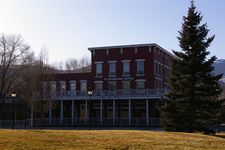
Historic St Charles Hotel in Carson City 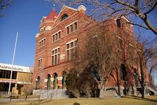
Former Carson City Post Office 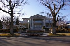
The Governor's Mansion in Carson City 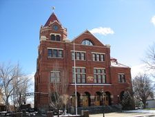
Paul Laxalt State Building - formerly the U.S. Court House & Post Office, now home to the Nevada Commission on Tourism


_-_CARSON_CITY,_NV.svg&filetimestamp=20240415195753)
انظر أيضاً
المراجع
- ^ "Population and Housing Unit Estimates". Retrieved June 9, 2017.
- ^ أ ب "About Carson City". Carson City. May 29, 2006. Retrieved November 20, 2011.
- ^ Pritzker, Barry M. (2000). A Native American Encyclopedia: History, Culture, and Peoples. Oxford: Oxford University Press. ISBN 978-0195138771.
- ^ "National Park Service: Three Historic Cities". Travel Nevada.com. Retrieved June 2, 2010.
- ^ Bayer, C.W. (1995). Profits, plots & lynching; the creation of Nevada Territory. Carson City: Purple Mountain Press. p. 2. ISBN 0962889032.
- ^ Oldham, Willa (1991). Carson City: Nevada's Capital City. Carson City, NV: Nevada State Museum. p. 5. ASIN B0006QSL8Q.
- ^ Cerveri, Doris (1990). With Curry's Compliments: The Story of Abraham Curry. Elko, NV: Nostalgia Press. p. 13.
- ^ Hauck, Eldon (1991). American Capitols. Jefferson, NC: McFarland & Company, Inc. p. 138.
- ^ Kelli Du Fresne. "Dedicated to Carson's Chinese history". Nevada Appeal. Archived from the original on April 7, 2012. Retrieved September 7, 2011.
- ^ Carson City Government. "Carson City: History". Archived from the original on July 25, 2011. Retrieved February 6, 2021.
- ^ Staff Writer. "About Carson City". Emporis. Archived from the original on October 23, 2012. Retrieved May 23, 2021.
- ^ "Carson City High Rise Buildings". Emporis.com. Archived from the original on October 23, 2012. Retrieved January 17, 2013.
- ^ Benchmark Maps (2003). Nevada Road and Recreation Atlas (Map) (2003 ed.). 1:280,000. Medford, OR: Benchmark Maps. ISBN 0-929591-81-X.
- ^ أ ب "U.S. Climate Normals Quick Access". National Oceanic and Atmospheric Administration. Archived from the original on 2023-08-15. Retrieved September 17, 2022.
- ^ Chereb, Sandra (2014-06-04). "Carson City leads nation in warming trend". The Associated Press. Archived from the original on 2014-07-14. Retrieved 2017-10-07.
- ^ "NOAA Online Weather Data". National Weather Service. Retrieved September 17, 2022.
- ^ "Stewart Indian School – Three Historic Nevada Cities: Carson City, Reno and Virginia City – A National Register of Historic Places Travel Itinerary". Nps.gov. Retrieved 2013-01-17.
- ^ "The Historic James Doane Roberts House". Cchistorical.org. Archived from the original on August 28, 2013. Retrieved 2013-01-17.
- ^ http://nevadaculture.org/nsla/index.php?option=com_content&task=view&id=725&Itemid=95[dead link]
- ^ "Yesterday's Flyers". Retrieved April 19, 2012.
- ^ "Annual Estimates of the Resident Population for Counties: April 1, 2020 to July 1, 2023". United States Census Bureau. Retrieved March 26, 2024.
- ^ "U.S. Decennial Census". United States Census Bureau. Archived from the original on April 12, 2013. Retrieved December 20, 2014.
- ^ "Historical Census Browser". University of Virginia Library. Archived from the original on August 11, 2012. Retrieved December 20, 2014.
- ^ "Population of Counties by Decennial Census: 1900 to 1990". United States Census Bureau. Retrieved December 20, 2014.
- ^ "Census 2000 PHC-T-4. Ranking Tables for Counties: 1990 and 2000" (PDF). United States Census Bureau. Archived (PDF) from the original on 2010-03-27. Retrieved December 20, 2014.
- ^ "NowData - NOAA Online Weather Data". National Oceanic and Atmospheric Administration. Retrieved 2013-06-25.
- ^ Leip, David. "Dave Leip's Atlas of U.S. Presidential Elections". uselectionatlas.org. Retrieved December 25, 2017.
- ^ Presidential results until 1968 are Ormsby County results
وصلات خارجية
 Carson City travel guide from Wikivoyage
- Official website
- Carson City Convention and Visitors Bureau
- "Carson City". C-SPAN Cities Tour. August 2013.
- Pages using gadget WikiMiniAtlas
- Articles with dead external links from June 2016
- Short description is different from Wikidata
- Articles with hatnote templates targeting a nonexistent page
- Pages using multiple image with auto scaled images
- Coordinates on Wikidata
- Pages with empty portal template
- Official website different in Wikidata and Wikipedia
- كارسن سيتي، نـِڤادا
- مدن نـِڤادا
- مدن مستقلة في الولايات المتحدة
- أماكن مأهولة تأسست في 1858
- مقاطعات نـِڤادا
- تأسيسات 1858 في نـِڤادا
- مقار مقاطعات سابقة في نـِڤادا
- مدن الولايات المتحدة