فرانكفورت، كنتكي
فرانكفورت
Frankfort | |
|---|---|
Historic District, downtown Church of the Good Shepherd Frankfort in 2009 | |
 Flag  الشعار | |
 موقع فرانكفورت في مقاطعة فرانكلن، كنتكي. | |
 فرانكفورت موقع فرانكفورت في مقاطعة فرانكلن، كنتكي.  فرانكفورت فرانكفورت (الولايات المتحدة) | |
| الإحداثيات: 38°12′N 84°52′W / 38.200°N 84.867°W | |
| البلد | الولايات المتحدة |
| الولاية | كنتكي |
| المقاطعة | فرانكلن |
| تأسست | 1786 |
| أشهرت | February 28, 1835 |
| الحكومة | |
| • النوع | مجلس/مدير |
| • العمدة | وليام ماي |
| المساحة | |
| • الإجمالي | 14٫6 ميل² (37٫9 كم²) |
| • البر | 14٫3 ميل² (37٫1 كم²) |
| • الماء | 0٫3 ميل² (0٫8 كم²) |
| المنسوب | 509 ft (155 m) |
| التعداد (2010) | |
| • الإجمالي | 25٬527 |
| • Estimate (2016)[1] | 27٬885 |
| • الكثافة | 1٬746٫3/sq mi (674٫2/km2) |
| منطقة التوقيت | UTC−5 (Eastern (EST)) |
| • الصيف (التوقيت الصيفي) | UTC−4 (EDT) |
| ZIP Code | 40601-40604, 40618-40622 |
| مفتاح الهاتف | 502 |
| FIPS code | 21-28900 |
| GNIS feature ID | 0517517 |
| الموقع الإلكتروني | City website |
_(cropped).jpg&filetimestamp=20251210013408&)


.jpg&filetimestamp=20251210013406&)
.jpg&filetimestamp=20251210013405&)
فرانكفورت Frankfort هي عاصمة ولاية كنتكي ومقر مقاطعة فرانكلن.[2] It is a home rule-class city[3] في كنتكي؛ كان التعداد 25,527 نسمة في تعداد 2010. وتقع على نهر كنتكي، وهي المدينة الرئيسية في Frankfort, Kentucky Micropolitan Statistical Area، التي تضم كل مقاطعتي فرانكلن وأندرسون.
Before Frankfort was founded, the site was a ford across the Kentucky River, along one of the great buffalo trails used as highways in colonial America.[4] English explorers first visited the area in the 1750s. The site evidently received its name after an incident in 1780, when pioneer Stephen Frank was killed in a skirmish with Native Americans; the crossing was named "Frank's Ford" in his memory.[4] In 1786, the Virginia legislature designated 100 acre (40 هكتار) as the town of Frankfort and, after Kentucky became a state in 1792, it was chosen as capital.[4][5]
The city is located in the inner Bluegrass region of Kentucky.[6] The Kentucky River flows through the city, making a turn as it passes through the center of town; the Downtown and South Frankfort districts are opposite one another on each side of the river. The suburban areas on either side of the river valley are known as East and West Frankfort. Frankfort has four distinct seasons; winter is normally cool with some snowfall, while summers are hot and humid.[7][8]
Because of the city's location on the Kentucky River, it has flooded many times, with the two highest recorded floods occurring in 1937 and 1978.[6] The North Frankfort levee, finished in 1969, and the South Frankfort floodwall, built in the 1990s, were constructed for flood protection.[6] Five bridges cross the river in downtown Frankfort, including the St. Clair Street bridge and Capitol Avenue bridge.[6] Notable locations include the Kentucky State Capitol building, the Capital City Museum,[9] and Fort Hill, a promontory with a view of downtown.
As of 2016, the city's largest industry was public administration with 28% of the workforce.[10] Manufacturing totaled over 12% of the workforce.[10] Frankfort is adjacent to Interstate 64, and Interstate 75 is nearby; general aviation access is via the Capital City Airport, and commercial air travel is available through Blue Grass Airport in Lexington.[10]
التاريخ
القرنان 18 و 19
The town of Frankfort likely received its name from an event that took place in the 1780s. Native Americans attacked a group of early European colonists from Bryan Station, who were on their way to make salt at Mann's Lick in Jefferson County. Pioneer Stephen Frank was killed at the Kentucky River and the settlers thereafter called the crossing "Frank's Ford". This name was later elided to Frankfort.[11]
In 1786, James Wilkinson purchased a 260-acre (110-هكتار) tract of land on the north side of the Kentucky River, which developed as downtown Frankfort. He was an early promoter of Frankfort as the state capital. Wilkinson felt Frankfort would be a center of transportation using the Kentucky River to ship farm produce to the Ohio River and then to the Mississippi and on to New Orleans.
After Kentucky became the 15th state in 1792, five commissioners from various counties were appointed, on June 20, 1792, to choose a location for the capital. They were John Allen and John Edwards (both from Bourbon County), Henry Lee (from Mason), Thomas Kennedy (from Madison), and Robert Todd (from Fayette). A number of communities competed for this honor, but Frankfort won. According to early histories, the offer of Andrew Holmes' log house as capitol for seven years, a number of town lots, £50 worth of locks and hinges, 10 boxes of glass, 1،500 رطل (680 kg) of nails, and $3,000 in gold helped the decision go to Frankfort.[12]

Frankfort had a United States post office by 1794, with Daniel Weisiger as postmaster. On October 1, 1794, Weisiger sent the first quarterly account to Washington.[13]
John Brown, a Virginia lawyer and statesman, built a home now called Liberty Hall in Frankfort in 1796. Before Kentucky statehood, he represented Virginia in the Continental Congress (1777−78) and the U.S. Congress (1789−91). While in Congress, he introduced the bill granting statehood to Kentucky. After statehood, he was elected by the state legislature as one of the state's U.S. Senators.[14]
In 1796, the Kentucky General Assembly appropriated funds to provide a house to accommodate the governor; it was completed two years later. The Old Governor's Mansion is claimed to be the oldest official executive residence still in use in the United States. In 1829, Gideon Shryock designed the Old Capitol, Kentucky's third, in Greek Revival style. It served Kentucky as its capitol from 1830 to 1910. The separate settlement known as South Frankfort was annexed by the city on January 3, 1850.[15]
The Argus of Western America was published in Frankfort from 1808 until 1830.[16]
During the American Civil War, the Union Army built fortifications overlooking Frankfort on what is now called Fort Hill. The Confederate Army also occupied Frankfort for a short time, starting on September 3, 1862, the only such time that Confederate forces took control of a Union capitol.[11]
The Clinton Street High School, a segregated public school for African American students in Frankfort operated from either 1882 or 1884 until 1928.[17][18]
On February 3, 1900, William Goebel was assassinated in Frankfort while walking to the capitol on the way to the Kentucky Legislature. Former Secretary of State Caleb Powers and several others were later found guilty of a conspiracy to murder Goebel; however, all were later pardoned.[19]
القرن العشرون
.jpg&filetimestamp=20251210013402&)
The Mayo–Underwood School, the successor to the Clinton Street High School, was a public school for African American students in Frankfort and operated from 1929 until 1964.[17][18] The school was torn down as part of an urban renewal plan,[20] and to make way for the Capital Plaza.
The Capital Plaza was comprised the Capital Plaza Office Tower, the tallest building in the city, the Capital Plaza Hotel (formerly the Holiday Inn, Frankfort), and the Fountain Place Shoppes. The Capital Plaza Office Tower opened in 1972 and became a visual landmark for the center of the city. By the early 2000s, maintenance of the concrete structures had been neglected and the plaza had fallen into disrepair, with sections of the plaza closed to pedestrian activity out of concerns for safety. In 2018 The Capital Plaza was demolished[21] and a new state office building was constructed[22] to take its place. The new building was named The Mayo-Underwood State Office Building[23] to honor the namesake school that was razed for the sake of the original Capital Plaza.
Frankfort grew considerably with state government in the 1960s. A modern addition to the State Office Building was completed in 1967. The original building was completed in the 1930s on the location of the former Kentucky State Penitentiary. Some of the stone from the old prison was used for the walls surrounding the office building.[24]
21st century
Although there was some rapid economic and population growth in the 1960s, both tapered off in the 1980s and have remained fairly stable since that time.[25]
In August 2008, state government officials recommended demolition of the Capital Plaza Office Tower and redevelopment of the area over a period of years. Ten years later, the demolition of the office tower was completed on Sunday, March 11, 2018,[26] and was televised by WKYT-TV on WKYT-DT2, as well as streamed live on Facebook. Demolition of the nearby convention center, which opened in 1972 and has hosted sporting events, concerts, and other local events, was completed in spring 2018.[26] State officials replaced the outdated office tower with a smaller building called the Mayo–Underwood Building (2019),[27][28] in order to create a more pedestrian-oriented scale at the complex, to encourage street activity.[29]
Frankfort is home to three distilleries including the Buffalo Trace Distillery (Kentucky Bourbon), Castle & Key Distillery (spirits), and Three Boys Farm Distillery (bourbon and whiskey).[30]
In 2018, thousands of teachers protested at the city in response to Senate Bill 151 having been passed on March 29, 2018.[31] The bill was shortly overturned on December 13, 2018, by the Kentucky Supreme Court as unconstitutional, which prevented the bill from going into effect on January 1, 2019.
الجغرافيا

Frankfort is located in the (inner) Bluegrass region of Central Kentucky. The city is bisected by the Kentucky River, which makes an s-turn as it passes through the center of town. The river valley widens at this point, which creates four distinct parts of town. The valley within the city limits contains Downtown and South Frankfort districts, which lie opposite one another on the river. A small neighborhood with its own distinct identity, Bellepoint, is located on the west bank of the river to the north of Benson Creek, opposite the river from the "downtown" district. The suburban areas on either side of the valley are respectively referred to as the "West Side" and "East Side" (or "West Frankfort" and "East Frankfort").
According to the United States Census Bureau, the city has a total area of 14.6 ميل مربع (37.8 km2), of which 14.3 ميل مربع (37.0 km2) is land and 0.3 ميل مربع (0.78 km2) is water.
Frankfort does not have a commercial airport and travelers fly into Blue Grass Airport in Lexington, the closest; Cincinnati/Northern Kentucky International Airport near Covington or Louisville Muhammad Ali International Airport in Louisville. Capital City Airport serves general and military aviation.
المناخ
فرانكفورت لها مناخ شبه مداري رطب بأربع فصول متميزة للسنة. Winter is generally cool with some snowfall. Spring and fall are both mild and relatively warm, with ample precipitation and thunderstorm activity. Summers are hot and humid.
| بيانات المناخ لـ وسط فرانكفورت، كنتكي | |||||||||||||
|---|---|---|---|---|---|---|---|---|---|---|---|---|---|
| الشهر | ينا | فب | مار | أبر | ماي | يون | يول | أغس | سبت | أكت | نوف | ديس | السنة |
| القصوى القياسية °ف (°س) | 80 (27) |
80 (27) |
88 (31) |
95 (35) |
99 (37) |
106 (41) |
111 (44) |
105 (41) |
106 (41) |
98 (37) |
84 (29) |
78 (26) |
111 (44) |
| متوسط القصوى اليومية °ف (°س) | 41.5 (5.3) |
46.0 (7.8) |
55.8 (13.2) |
66.5 (19.2) |
75.2 (24.0) |
83.6 (28.7) |
87.3 (30.7) |
86.7 (30.4) |
80.4 (26.9) |
69.5 (20.8) |
57.3 (14.1) |
45.0 (7.2) |
66.2 (19.0) |
| المتوسط اليومي °ف (°س) | 31.7 (−0.2) |
35.3 (1.8) |
43.5 (6.4) |
53.5 (11.9) |
62.7 (17.1) |
71.5 (21.9) |
75.5 (24.2) |
74.6 (23.7) |
67.5 (19.7) |
56.2 (13.4) |
45.6 (7.6) |
35.4 (1.9) |
54.4 (12.4) |
| متوسط الدنيا اليومية °ف (°س) | 21.9 (−5.6) |
24.7 (−4.1) |
31.2 (−0.4) |
40.5 (4.7) |
50.1 (10.1) |
59.5 (15.3) |
63.8 (17.7) |
62.5 (16.9) |
54.6 (12.6) |
43.0 (6.1) |
34.0 (1.1) |
25.9 (−3.4) |
42.6 (5.9) |
| الصغرى القياسية °ف (°س) | −27 (−33) |
−16 (−27) |
−3 (−19) |
16 (−9) |
27 (−3) |
36 (2) |
48 (9) |
41 (5) |
30 (−1) |
20 (−7) |
−1 (−18) |
−17 (−27) |
−27 (−33) |
| متوسط تساقط الأمطار inches (mm) | 3.70 (94) |
3.07 (78) |
4.39 (112) |
3.74 (95) |
4.01 (102) |
4.06 (103) |
4.14 (105) |
3.45 (88) |
2.90 (74) |
2.53 (64) |
3.29 (84) |
3.49 (89) |
42.77 (1٬086) |
| متوسط هطول الثلج inches (cm) | 3.4 (8.6) |
2.8 (7.1) |
1.2 (3.0) |
0 (0) |
0 (0) |
0 (0) |
0 (0) |
0 (0) |
0 (0) |
0 (0) |
0.4 (1.0) |
1.6 (4.1) |
9.4 (24) |
| Average precipitation days (≥ 0.01 in) | 11 | 10 | 11 | 11 | 11 | 10 | 9 | 8 | 7 | 7 | 9 | 10 | 114 |
| Source: NOAA (normals 1981–2010),[32] Southeast Regional Climate Center (precipitation, snow and extremes 1895–2002)[33] and pogodaiklimat.ru[34] | |||||||||||||
الديمغرافيا
| التعداد | Pop. | ملاحظة | %± |
|---|---|---|---|
| 1800 | 628 | — | |
| 1810 | 1٬099 | 75�0% | |
| 1820 | 1٬679 | 52٫8% | |
| 1830 | 1٬682 | 0٫2% | |
| 1840 | 1٬917 | 14�0% | |
| 1850 | 3٬308 | 72٫6% | |
| 1860 | 3٬702 | 11٫9% | |
| 1870 | 5٬396 | 45٫8% | |
| 1880 | 6٬958 | 28٫9% | |
| 1890 | 7٬892 | 13٫4% | |
| 1900 | 9٬487 | 20٫2% | |
| 1910 | 10٬465 | 10٫3% | |
| 1920 | 9٬805 | −6٫3% | |
| 1930 | 11٬626 | 18٫6% | |
| 1940 | 11٬492 | −1٫2% | |
| 1950 | 11٬916 | 3٫7% | |
| 1960 | 18٬365 | 54٫1% | |
| 1970 | 21٬902 | 19٫3% | |
| 1980 | 25٬973 | 18٫6% | |
| 1990 | 25٬968 | 0�0% | |
| 2000 | 27٬741 | 6٫8% | |
| 2010 | 25٬527 | −8�0% | |
| 2020 | 28٬602 | 12�0% | |
| 2024 (تق.) | 28٬610 | [35] | 0�0% |
| U.S. Decennial Census[36][المصدر لا يؤكد ذلك] 2020[37] | |||
As of the 2020 United States census,[38] there were 28,602 people, 12,434 households, and 6,053 families residing in the city. The population density was 1،783 per square mile (688/km2). There were 12,938 housing units at an average density of 885.1 per square mile (341.7/km2). The racial makeup of the city was 75.1% White or European American (74.1% non-Hispanic), 13.3% Black or African American, 0.2% Native American, 2.6% Asian, 0.0% Pacific Islander, 1.8% from other races, and 4.8% from two or more races. Hispanics or Latinos of any race were 5.2% of the population.
There were 12,434 households, out of which 27.9% had children under the age of 18 living with them, 32,6% were married couples living together, 16.7% had a female householder with no husband present, 5.1% had a male householder with no wife present, and 45.7% were non-families. 38.3% of all households were made up of individuals, and 12.2% had someone living alone who was 65 years of age or older. The average household size was 2.12 and the average family size was 2.83.
The age distribution was 19.8% under 18, 13.1% from 18 to 24, 26.6% from 25 to 44, 25.5% from 45 to 64, and 16.1% who were 65 or older. The median age was 36.7 years. For every 100 females, there were 92.9 males. For every 100 females age 18 and over, there were 89.4 males.
The median income for a household in the city was $50,211, and the median income for a family was $43,949. Full-time male workers had a median income of $37,445 versus $34,613 for females. The per capita income was $29,288. About 19.8% of families and 16.3% of the population were below the poverty line, including 38.7% of those under age 18 and 7.5% of those age 65 or over.
Frankfort is the focal point of a micropolitan statistical area consisting of Frankfort and Franklin County as well as adjacent Lawrenceburg and Anderson County. The city is also classified in a combined statistical area with Lexington and Richmond to the east.
Frankfort's municipal population makes it the fourth least populous capital city in the United States.[39]
المنتزهات والترفيه
The city operates nine parks:[40]
- Capitol View—playing fields, nature trails, picnic areas
- Cove Spring Park—240 acre (97 هكتار), divided into three sections. The Lower Entrance features nature trails, picnic areas, and waterfalls. The Upper Entrance includes an archery range and the Sky Trail. The Middle Section consists of a wetland area with a walking trail leading to a scenic overlook with views of downtown Frankfort.
- Dolly Graham—basketball courts, picnic, community garden, playground
- East Frankfort—nature trails, dog park, picnic areas, playgrounds, volleyball court, 18-hole disc golf course.[41]
- Juniper Hill Park—124 acre (50.2 هكتار), pool, golf course, play areas, picnic areas, war memorials
- Lakeview (operated jointly with Franklin County[42])—ball fields, golf course, horse show arena, skatepark
- Leslie Morris Park on Fort Hill—American Civil War battlefield, wilderness forest, forts, trails
- River View—picnic area along the Kentucky River, walking trail with historic cultural sites, amphitheatre, boat ramp, farmers market
- Todd Park—trail, picnic areas, community garden
Other recreation in the area:
- Walk/Bike Frankfort - Volunteer group to improve the city for pedestrians and cyclists.[43]
- Josephine Sculpture Park - Provides community arts education and creative experiences.[44]
- The Folkbike Re-Cyclery - Volunteer organization that restores and repairs used bicycles, and then gives them to riders who cannot afford to buy one.[45][46]
التعليم
Kentucky State University is located with the Frankfort city limits. KSU (also known as KYSU) is a public historically black university and an 1890 land-grant institution.[47]
Two public school districts serve the city,[48] with three public high schools within the city limits.[47]
Frankfort Independent School District serves the downtown neighborhoods including Downtown, South Frankfort, Bellepoint and Tanglewood. FIS operates The Early Learning Academy (a preschool), Second Street School (primary and middle grades), Frankfort High School, and Panther Transition Academy (a non-traditional high school program).[49]
Franklin County Public Schools serves the rest of the city and county, including seven elementary schools (Bridgeport, Collins Lane, Early Learning Village, Elkhorn, Hearn, Peaks Mill, Westridge), two middle schools (Bondurant, Elkhorn), and two high schools (Franklin County High School and Western Hills High School).[50]
There are several private schools in the area, including Capital Day School, Frankfort Christian Academy, and Good Shepherd Catholic School.
Frankfort has a lending library, Paul Sawyier Public Library, named in 1965 after the watercolor artist Paul Sawyier whose many paintings document the history of the area.[51][52][53]
المعالم

- Kentucky State Capitol building, built 1909
- Kentucky Governor's Mansion, residence of the Governor of Kentucky, built 1914
- Old State Capitol building, now a museum, built 1837
- Courthouse, built 1887
- Singing Bridge, a 125-year-old bridge that crosses the Kentucky River, built 1893
- Liberty Hall, historic house museum, built 1796
- Fort Hill, a hill overlooking downtown, American Civil War site, now a park
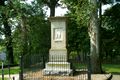
- Frankfort Cemetery, historic military monuments and final resting place of numerous statesmen and famous figures, established 1844
- Corner in Celebrities Historic District
- Buffalo Trace Distillery, built 1792
- Jesse R. Zeigler House (private), Kentucky's only Frank Lloyd Wright, built 1909
- Capital City Museum, a repository of the history of Frankfort and Franklin County[9]
- Leestown, Kentucky (historical site established in 1775, currently in the city of Frankfort)
المدن الشقيقة
معرض صور

The floral clock near the Capitol building
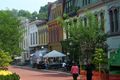
Downtown Frankfort
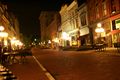
Downtown Frankfort at night
Gravesite of pioneer Daniel Boone and his wife at Frankfort Cemetery
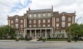
Jackson Hall of Kentucky State University
Whitaker Bank building


.jpg&filetimestamp=20251210013402)
المراجع
- ^ "Population and Housing Unit Estimates". Retrieved June 9, 2017.
- ^ "Find a County". National Association of Counties. Archived from the original on May 31, 2011. Retrieved June 7, 2011.
- ^ "Summary and Reference Guide to House Bill 331 City Classification Reform" (PDF). Kentucky League of Cities. Archived (PDF) from the original on November 11, 2014. Retrieved December 30, 2014.
- ^ أ ب ت "City History". Official website. City of Frankfort, Kentucky. Archived from the original on July 18, 2016. Retrieved July 1, 2016.
- ^ "Kentucky Historical Marker 1774" Archived أغسطس 18, 2006 at the Wayback Machine. Kentucky Historical Society Website
- ^ أ ب ت ث "Geography | Frankfort, KY". www.frankfort.ky.gov. Archived from the original on 2023-06-11. Retrieved 2023-06-11.
- ^ "Station: Frankfort Lock 4, KY". U.S. Monthly Climate Normals (1981-2010). National Oceanic and Atmospheric Administration. Retrieved June 4, 2021.
- ^ "Monthly Highest Max Temperature and Monthly Lowest Min Temperature for Frankfort Downtown, KY". Applied Climate Information System. Retrieved June 4, 2021.
- ^ أ ب "Capital City Museum | Frankfort KY". www.capitalcitymuseum.com. Retrieved 2022-07-12.
- ^ أ ب ت "Economy | Frankfort, KY". www.frankfort.ky.gov. Retrieved 2023-06-11.
- ^ أ ب "City History". Official website. City of Frankfort, Kentucky. Archived from the original on July 18, 2016. Retrieved July 1, 2016.
- ^ "Kentucky Historical Marker 1774" Archived أغسطس 18, 2006 at the Wayback Machine. Kentucky Historical Society Website
- ^ Rennick, Robert M. (1993) Kentucky's Bluegrass: A Survey of the Post Offices, pp. 91 & 99. Lake Grove, Oregon: The Depot, ISBN 0-943645-31-X. Post Office Department records were destroyed by a fire in 1836.
- ^ "Biographical Directory of the U.S. Congress - Retro Search". Biographical Directory of the United States Congress.
- ^ Commonwealth of Kentucky. Office of the Secretary of State. Land Office. "Frankfort, Kentucky". Accessed July 25, 2013.
- ^ "How Politicians Bought the 19th Century Media". Steve Inskeep: NPR Host and Author. May 4, 2015.[dead link]
- ^ أ ب "African American Schools in Frankfort and Franklin County, KY". Notable Kentucky African Americans Database, University of Kentucky Libraries, University of Kentucky. Retrieved 2023-02-06.
- ^ أ ب Boyd, Douglas (2011-08-01). Crawfish Bottom: Recovering a Lost Kentucky Community (in الإنجليزية). University Press of Kentucky. pp. 93–96. ISBN 978-0-8131-3409-3.
- ^ Egerton, John (April 10, 1983). Generations: An American Family. University Press of Kentucky. ISBN 0813127831 – via Google Books.
- ^ "Capital Plaza Authority Asks Mayo–Underwood School Site". The Lexington Herald. 1966-08-31. p. 13. Retrieved 2023-02-06.
- ^ "Capital Plaza Tower Demolished in Frankfort – CTBUH". www.ctbuh.org. Retrieved 2025-02-27.
- ^ "The Mayo-Underwood Building". EOP Architects (in الإنجليزية الأمريكية). Archived from the original on February 27, 2025. Retrieved 2025-02-27.
- ^ Thompson, Mark Henderson (2019-08-13). "Capital Plaza Office Building Named Mayo-Underwood". EOP Architects (in الإنجليزية الأمريكية). Archived from the original on February 27, 2025. Retrieved 2025-02-27.
- ^ "Knight's Penny Magazine". Charles Knight & Company. April 10, 1834 – via Google Books.
- ^ Jochim, Mark Joseph (2018-05-31). "Kentucky & Tennessee Statehood". A Stamp A Day (in الإنجليزية). Retrieved 2021-01-10.
- ^ أ ب Miller, Alfred (2018-01-14). "Dates set for Frankfort Convention Center, Capital Plaza Tower demolition". Lexington Herald-Leader. Archived from the original on January 16, 2018. Retrieved 2018-01-15.
- ^ "State office building named after historic Frankfort African American school". The State Journal (in الإنجليزية). August 13, 2019. Retrieved 2023-02-06.
- ^ "New state office building in downtown Frankfort officially named". ABC 36 News (in الإنجليزية الأمريكية). 2019-08-13. Retrieved 2023-02-06.
- ^ Redevelopment Plan",[dead link] Kentucky
- ^ "Home of the Distilleries of Bourbon Country". Bourbon Country.
- ^ Blackford, Linda. "See the best video, photos as Kentucky teachers pack Frankfort, protest in the Capitol". kentucky. Archived from the original on December 23, 2018. Retrieved December 22, 2018.
- ^ "Station Name: KY Frankfort Downtown". National Oceanic and Atmospheric Administration. Retrieved May 18, 2013.
- ^ "General Climate Summary tables". Southeast Regional Climate Center. Archived from the original on March 31, 2014. Retrieved May 18, 2013.
- ^ "Климат Франкфорта - Погода и климат". www.pogodaiklimat.ru. Retrieved 2019-06-20.
- ^ Bureau, US Census. "City and Town Population Totals: 2020-2024". Census.gov (in الإنجليزية). Retrieved 2025-11-06.
- ^ "Census of Population and Housing". Census.gov. Retrieved June 4, 2015.
- ^ "QuickFacts: Frankfort city, Kentucky". census.gov. Retrieved 2022-01-02.
- ^ "U.S. Census website". United States Census Bureau. Retrieved May 14, 2011.
- ^ "The 10 Least Populated State Capitals". WorldAtlas (in الإنجليزية الأمريكية). 2018-11-21. Retrieved 2022-06-21.
- ^ "Parks". www.frankfortparksandrec.com. Archived from the original on February 26, 2020. Retrieved May 18, 2020.
{{cite web}}: CS1 maint: unfit URL (link) - ^ "Lawrenceburg Disc Golf Association - Lawrenceburg (KY) Disc Golf Association". Lawrenceburg Disc Golf Association. Archived from the original on January 19, 2019. Retrieved November 26, 2019.
- ^ "Parks & Recreation | Franklin County".
- ^ "Walk/Bike Frankfort". Archived from the original on February 19, 2010. Retrieved December 11, 2011.
- ^ "Josephine Sculpture Park". Archived from the original on September 20, 2019. Retrieved November 26, 2019.
- ^ "The Folkbike Re-Cyclery - Join The Revolution - Frankfort, KY". folkbikerecyclery.org. Archived from the original on October 28, 2012. Retrieved November 26, 2019.
- ^ Staff (May 1, 2013). "How to Celebrate Kentucky Derby 2013 in Central Kentucky". Ace. Archived from the original on October 13, 2016. Retrieved June 8, 2017.
- ^ أ ب "Education | Frankfort, KY". www.frankfort.ky.gov.
- ^ "2020 census - school district reference map: Franklin County, KY" (PDF). U.S. Census Bureau. Retrieved 2022-08-11. - Text list - For more detailed boundaries of the independent school districts see: "Appendix B: Maps Of Independent School Districts In Operation In FY 2014-FY 2015 Using 2005 Tax District Boundaries – Frankfort ISD" (PDF). Research Report No. 415 – Kentucky's Independent School Districts: A Primer. Frankfort, KY: Office of Education Accountability, Legislative Research Commission. September 15, 2015. p. 110 (PDF p. 124/174).
- ^ "Frankfort Independent Schools". www.frankfort.k12.ky.us. Archived from the original on February 9, 2019. Retrieved 2019-02-07.
- ^ "Franklin County Schools". www.franklin.kyschools.us.
- ^ "Kentucky Public Library Directory". Kentucky Department for Libraries and Archives. Archived from the original on January 11, 2019. Retrieved May 18, 2020.
- ^ Roe, Amy. "Paul Sawyier Library". ExploreKYHistory. Retrieved May 18, 2020.
- ^ "Paul Sawyier Art Exhibit". pspl.org. September 8, 2018. Archived from the original on September 21, 2021. Retrieved May 18, 2020.
- ^ "New sister city official | The State Journal". www.state-journal.com. Archived from the original on February 27, 2018. Retrieved 2018-02-26.
وصلات خارجية
- Official site
- Frankfort Information page from Kentucky Secretary of State
- . The American Cyclopædia. 1879.
- Pages using gadget WikiMiniAtlas
- Articles with dead external links from January 2022
- CS1 الإنجليزية الأمريكية-language sources (en-us)
- CS1: Julian–Gregorian uncertainty
- CS1 maint: unfit URL
- Short description is different from Wikidata
- Pages using multiple image with auto scaled images
- Coordinates on Wikidata
- مقالات ذات عبارات بحاجة لمصادر
- Wikipedia articles incorporating a citation from The American Cyclopaedia
- Wikipedia articles incorporating a citation from The American Cyclopaedia with a Wikisource reference
- فرانكفورت، كنتكي
- مدن كنتكي
- مدن في مقاطعة فرانكلن، كنتكي
- University towns in the United States
- County seats in Kentucky
- أماكن مأهولة تأسست في 1786
- Frankfort, Kentucky micropolitan area
- تأسيسات 1786 في ڤرجينيا