جغرافيا نيوجرزي
جغرافيا نيوجرزي
نيوجرزي يحدها من الشمال والشمال الشرقي نيويورك; ومن الشرق المحيط الأطلنطي; ومن الجنوب والجنوب الغربي دِلاوير عبر خليج دِلاوير; ومن الغرب پنسيلڤانيا على الضفة المقابلة من نهر دِلاوير.
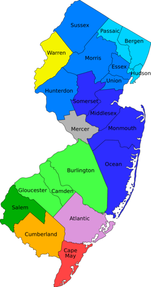
ويمكن التفكير في نيوجرزي على أنها مكونة من خمس مناطق, على أساس الجغرافيا الطبيعية والسكان. شمال شرق نيوجرزي, منطقة المدخل Gateway Region, وتقع ضمن New York metropolitan area, وبعض قاطنيها يعملون في مدينة نيويورك. شمال غرب نيوجرزي, أو "أراضي السماء Skylands", وهي, بالمقارنة بالشمال الشرقي, فتحتوي على غابات أكثر, وهي أكثر ريفية, وجبلية, ولكنها ما زالت مكاناً ذا جاذبية للسكنى. "الشاطئ Shore" على امتداد ساحل الأطلنطي في الجنوب الشرقي له ساكنوه وخصائص نمط حياته بسبب المحيط. الجنوب الغربي يقع ضمن حزام (كوريدور) فيلادلفيا, ويعتبر ضمن وادي دِلاوير. المنطقة الخامسة هي جرود الصنوبر Pine Barrens في داخل الجزء الجنوبي ويغطيها غابة صنوبريات وبلوط كثيفة ومختلفة الأنواع, ولذلك فكثافة سكانها أقل بكثير من باقي الولاية.
ويمكن كذلك تقسيم نيوجرزي عموماً إلى ثلاث مناطق جغرافية: شمال جرزي, وسط جرزي, وجنوب جرزي. إلا أن البعض لا يعتقد في وجود وسط جرزي على الإطلاق, وفي المقابل يعتقد الكثيرون (من سكان الوسط) أنه منطقة جغرافية وثقافية منفصلة عن الشمال والجنوب.
يغطي السهل الساحلي الواقع على الأطلسي الجزء الجنوبي من نيوجيرسي. وتقع الشواطئ، والغابات ومستنقعات الملح والأهوار والمروج في المنطقة الشرقية من السهل. وتدعم الأرض الخصبة البستنة التجارية في الجنوب والغرب.
تقع منطقة أراضي البيدمونت عند شمال السهل الساحلي. تساعد الأنهار الكبيرة مثل الهدسون والباسايك والرامابو والراريتان المدن الصناعية الضخمة بالمنطقة. وتقع الأراضي المرتفعة الخاصة بنيو إنجلاند التي تسمى هايلاندز شمال غربي البيدمونت. وتحتوي هذه الأراضي على العديد من البحيرات وسلاسل الجبال ذات القمم المسطحة المكونة من الصخر الصلب المسمى الصخر الصواني.
وتحتل سلسلة جبال الأبلاش ومنطقة فالي الركن الشمالي الشرقي لنيوجيرسي. وتوجد تكوينات من الطَفْل الصفحي والحجر الجيري في وادي الأبلاش، وتنتشر المزارع في منحدرات الوادي، وتمتد جبال الكيتاتيني في موازاة حدود الولاية. ويقطع نهر ديلاوير الجبال عند قمة مياه ديلاوير بديعة المنظر.
تقع نيوجرسي بين مدينتي نيويورك وفيلادلفيا في بنسلفانيا. وهما من أكبر المدن في الولايات المتحدة. وتمثلان سوقين عملاقين لبضائع وخدمات نيوجيرسي. ويقوم العديد من سكان نيوجيرسي برحلات يومية إلى مقار أعمالهم في مدينتي نيويورك وفيلادلفيا.
المساحة
New Jersey is ranked 47th of the fifty states that comprise the United States of America in terms of area. The total area of the state is 8،729 ميل مربع (22،610 km2), of which 14.9% or 1،304 ميل مربع (3،380 km2) is water, and 85.1%, or 7،425 ميل مربع (19،230 km2), is land. New Jersey spans 70 miles (110 km) at its widest, and 166 miles (267 km) in length.
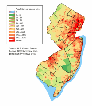
Due to its small size, New Jersey, which ranks eleventh in the nation in terms of population with 8,791,894 people, ranks first in population density, with 1،189 inhabitants per square mile (459/km2). However, while this offers the impression that New Jersey is entirely urban or suburban, it is not. Large swaths of northwestern and southern New Jersey are extremely rural. For example, Walpack Township in Sussex County, has a population of 39 and an area of 26 ميل مربع (67 km2).
الجغرافيا السياسية
The State of New Jersey is divided into 21 counties, which contain a total of 566 municipalities. Like many New England states, all land in New Jersey is incorporated. New Jersey municipalities have a strong tradition of independent home rule which, as a result, means that county government is comparatively weaker than in other states and more open to criticisms of waste and ineffectiveness.[1]
المناخ
| Average high and low temperatures in various cities of New Jersey °C (°F) | |||||||||||||
| المدينة | Jan | Feb | Mar | Apr | May | Jun | Jul | Aug | Sep | Oct | Nov | Dec | |
|---|---|---|---|---|---|---|---|---|---|---|---|---|---|
| Sussex | 1/-10 (33/14) | 3/-9 (38/16) | 8/-4 (46/25) | 15/2 (59/36) | 21/7 (70/45) | 26/12 (78/54) | 28/15 (83/59) | 28/14 (82/57) | 23/9 (73/48) | 17/3 (63/38) | 11/-1 (52/30) | 4/-6 (39/21) | |
| Newark | 3/-4 (38/25) | 5/-3 (41/27) | 10/1 (50/34) | 16/7 (61/45) | 22/12 (72/54) | 27/18 (81/64) | 29/21 (84/70) | 28/20 (82/68) | 24/16 (75/61) | 18/9 (64/48) | 12/4 (54/39) | 6/-1 (43/30) | |
| Atlantic City | 5/-2 (42/28) | 6/-1 (44/30) | 9/3 (48/38) | 14/7 (57/45) | 19/13 (66/56) | 24/18 (75/64) | 27/21 (80/70) | 27/21 (80/70) | 23/18 (73/64) | 18/12 (64/54) | 13/6 (55/44) | 8/1 (46/34) | |
| Cape May | 6/-3 (43/27) | 6/-2 (43/28) | 11/2 (52/36) | 16/6 (61/43) | 21/12 (70/54) | 26/17 (79/63) | 29/19 (84/66) | 28/19 (82/66) | 25/16 (77/61) | 19/9 (66/48) | 13/4 (55/39) | 8/-1 (46/30) | |
| Weather.com[1] | |||||||||||||
الجيولوجيا
Around 250 million years ago, during the Paleozoic and Mesozoic eras, the area that is today New Jersey bordered northern Africa as part of the supercontinent of Pangea. The pressure of the collision between North America and Africa gave rise to the Appalachian Mountains. Around 200 million years ago, Pangea began to break apart, separating the North American continent from the African continent. Around 18,000 years ago, the most recent ice age resulted in glaciers that reached New Jersey. As the glaciers retreated, they left behind Lake Passaic, as well as many rivers, swamps, and gorges.[2]
الأقاليم الفيزيوغرافية
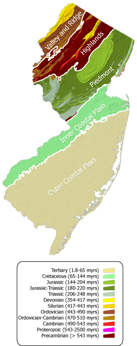
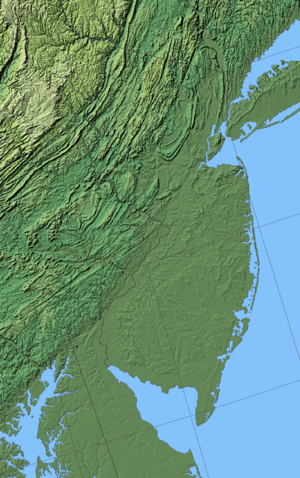
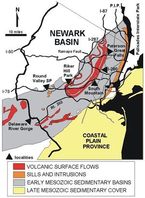
New Jersey is a region with a high variety of geographical features in a small area. The area can be broken into five regions, corresponding roughly to geological zones. These regions from north to south are the Appalachian Valley and Ridge, Highlands, Newark Basin Piedmont, Inner Coastal Plain, and the Outer Coastal Plain.
إقليم الوادي والجرف الأپلاشيين الفيزيوغرافي
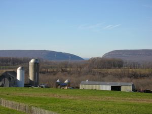
The Appalachian Valley and Ridge lies in the northwestern corner of the state and includes the جبال كيتاتني, several smaller valleys and the popular Delaware Water Gap. The state's highest point, the aptly named High Point is within this area, at 1،803 أقدام (550 m). Most of the state's section of the Appalachian Trail runs through this area. The province is bounded on the southeast by an unconformity between Cambrian and Precambrian formations.
إقليم المرتفعات الفيزيوغرافي
پيدمونت حوض نوارك
السهل الساحلي الداخلي
The Inner Coastal Plain province consists of lowlands and rolling hills underlain by Cretaceous deposits. Surficial geology in this region contains a number of fossils. The Monmouth County Park system, for example, includes a number of creeks where students and enthusiasts can gain real field exposure to cretaceous geology and paleontology. (Always check with the park service staff regarding permissibility before entering any field site.) The region's northwest border lies along the Piedmont Fall Line. Fertile, loamy soil makes the land ideal for agriculture and is responsible for New Jersey's nickname of the "Garden State". Its deposits of Greensand marl containing potash were used since colonial days by farmers to fertilize their fields.
السهل الساحلي الخارجي
The outer coastal plain consists of unconsolidated Tertiary deposits of sands, silt, and gravels. The soils are sandy with less clay than the inner coastal plain, and are more acidic and dry. The lack of fertility makes much of the region unsuitable for agriculture and large areas remain undeveloped. The sandy Pine Barrens, an area that is agriculturally poor but species rich, occupy the center of the province. Blueberries and cranberries have been cultivated in lowland bogs that have accumulated depths of organic matter.
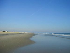
Along the coast, sandy beaches attract a recreation industry, and the offshore barrier islands are popular vacation destinations.
البيئة الطبيعية
New Jersey's natural environment preserves a range of habitats ranging from the Atlantic shore to the Appalachian Mountains.[3] The sandy uplands of South Jersey are home to the Atlantic coastal pine barrens. Surrounding the Pine Barrens, along the coast and covering the Inner Coastal Plain and Piedmont, are the Northeastern coastal forests. The Highlands consist of Appalachian-Blue Ridge forests which grade into Allegheny Highlands forests in the far northeast.[4]
المناطق الثقافية
الهجرات التاريخية
الجاليات العرقية في نيوجرزي الحالية
التقسيمات الثقافية الإقليمية
انظر أيضاً
الهامش
- ^ N.J. County Governments Coming Under Fire[dead link], Associated Press, Oct. 31, 2005
- ^ Geological History Archived 2007-07-04 at the Wayback Machine by Great Swamp Watershed Association, retrieved December 22, 2006.
- ^ Collins, B. R.; Anderson, K. H. (1994). Plant Communities of New Jersey: A Study in Landscape Diversity. Rutgers University Press. ISBN 978-0-8135-2071-1.
- ^ Olson, D. M, E. Dinerstein; et al. (2001). "Terrestrial Ecoregions of the World: A New Map of Life on Earth". BioScience. 51 (11): 933–938. doi:10.1641/0006-3568(2001)051[0933:TEOTWA]2.0.CO;2. Archived from the original on January 25, 2010.
{{cite journal}}: Unknown parameter|deadurl=ignored (|url-status=suggested) (help)CS1 maint: multiple names: authors list (link)
