بحيرة ملاوي
| بحيرة نياسا Lake Nyasa | |
|---|---|
 View from orbit North is in upper right corner | |
 بحيرة نياسا Lake Nyasa  بحيرة نياسا Lake Nyasa | |
| الإحداثيات | 12°00′S 34°30′E / 12.000°S 34.500°E |
| Lake type | Ancient lake, Rift lake |
| الموارد الرئيسية | نهر روهوهو[1] |
| التصريفات الرئيسية | نهر شاير[1] |
| بلدان الحوض | ملاوي، موزمبيق، تنزانيا |
| أقصى طول | 560 كم[1] إلى 580 كم[2] |
| أقصى عرض | 75 كم[1] |
| مساحة السطح | 29.600 كم² |
| متوسط العمق | 292 م[3] |
| أقصى عمق | 706 م[3] |
| حجم المياه | 8,400 كم³[3] |
| ارتفاع السطح | 468 متر فوق سطح البحر[4] |
| الجزر | جزيرة ليكومو وچيزومولو |
| المراجع | [1][3] |
| الاسم الرسمي | Lake Niassa and its Coastal Zone |
| التوصيف | 26 April 2011 |
| الرقم المرجعي | 1964[5] |
بحيرة ملاوي Lake Malawi (وتُعرف أيضاً بإسم بحيرة نياسا Lake Nyasa، أو Lake Nyassa، Lake Niassa، أو Lago Niassa في موزمبيق)، هي إحدى البحيرات العظمى الأفريقية وأقصى البحيرات جنوباً في نظام فالق شرق أفريقيا. وهذه البحيرة هي ثالث أكبر بحيرة في أفريقيا وثامن أكبر بحيرة في العالم، وتقع بين ملاوي وموزمبيق وتنزانيا. وهي ثاني أعمق بحيرة في أفريقيا، بالرغم من أن شاطئها الشمالي الضحل لا يعطي أي دلالة على عمقها. يعيش في مياهها الإستوائية أنواع أسماك أكثر بكثير من مثيلاتها من مسطحات المياه العذبة على الأرض، ومنها ما يزيد عن 1000 نوع من أسماك السكليد.[6]
في 10 يونيو 2011، أعلنتها حكومة موزمبيق كمحمية في إطار الجهود المبذولة لحماية واحدة من أكبر بحيرات المياه العذبة من حيث المساحة والتنوع البيولوجي، في العالم.[7] while in Malawi a portion of the lake is included in Lake Malawi National Park.[8]
Lake Malawi is a meromictic lake, meaning that its water layers do not mix. The permanent stratification of Lake Malawi's water and the oxic-anoxic boundary (relating to oxygen in the water) are maintained by moderately small chemical and thermal gradients.[9]
الجغرافيا
تمتد بحيرة نياسا أو بحيرة ملاوي بطول من 560[1] إلى 580 كيلو متر،[2] وحرض 75 تقريباً، عند أعرض نقطة. وتقدر مساحة سطحها بحوالي 29.600 كم².[1] وللبحيرة شواطئ في غرب موزمبيق، شرق ملاوي، وجنوب تنزانيا. وأكبر نهر يصب فيها هو نهر روهوهو، ويوجد مصب في نهائيتها الجنوبية، حيث نهر شاير، أحد الروافد التي تصب في نهر زامبيزي العملاق في موزمبيق.[2]
تقع البحيرة على وادي تكون على انقسام فالق شرق أفريقيا، حيث انقسمت الصفيحة التكتونية الأفريقية إلى جزئين. وهو ما يطلق عليه تباعد الصفائح التكتونية. بحيرة نياسا - أو ملاوي نفسها - قد تكونت منذ بحوالي 40.000 سنة.[1] أو حوالي 1-2 مليون سنة.[10]تقع البحيرة على بعد 350 كم جنوب شرق بحيرة طنجانيقا، واحدة من أكبر البحيرات العظمى في فالق شرق أفريقيا.
The lake is about 350 كيلومتر (220 mi) southeast of Lake Tanganyika, another of the great lakes of the East African Rift.[بحاجة لمصدر]
The Lake Malawi National Park is located at the southern end of the lake.[11]

Lake Malawi (1967)
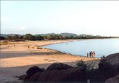
Mwaya Beach
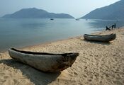
Beach at Cape Maclear near Monkey Bay


التاريخ الجيولوجي

 |
Malawi is one of the major Rift Valley lakes and an ancient lake. The lake lies in a valley formed by the opening of the East African Rift, where the African tectonic plate is being split into two pieces. This is called a divergent plate tectonics boundary. Malawi has typically been estimated to be 1–2 million years old (mya),[12][13] but more recent evidence points to a considerably older lake with a basin that started to form about 8.6 mya and deep-water condition first appeared 4.5 mya.[14][15]
The water levels have varied dramatically over time, ranging from almost 600 m (2،000 ft) below current level[16] to 10–20 m (33–66 ft) above.[14] During periods the lake dried out almost completely, leaving only one or two relatively small, highly alkaline and saline lakes in what currently are Malawi's deepest parts.[14][16] A water chemistry resembling the current conditions only appeared about 60,000 years ago.[16] Major low-water periods are estimated to have occurred about 1.6 to 1.0–0.57 million years ago (where it might have dried out completely), 420,000 to 250,000–110,000 years ago,[14] about 25,000 years ago and 18,000–10,700 years ago.[15] During the peak of the low-water period between 1390 and 1860 AD, it may have been 120–150 m (390–490 ft) below current water levels.[13]
الاكتشاف الأوروپي والاستعمار

كان التاجر الپرتغالي كانديدو خوسيه دا كوستا كاردوسو أول أوروپي يزور البحيرة عام 1846.[17] وصل داڤيد ليڤينگستون للبحيرة عام 1859، وأعاد تسميتها "ببحيرة نياسا".[2] فيما بعد طالبت الامبراطورية البريطانية بمعظم المنطقة الأفريقية المحيطة بالبحيرة وأسست فيها مستعمرة نياسالاند. بالرغم من أن الپرتغاليين كانوا يسيطرون على الشاطئ الشرقي للبحيرة، فقد استخدمت ليكومو كمحطة لمهمة الجامعات في وسط أفريقيا، ونتيجة لذلك، ضمت ليكوما وجزيرة چيزومولو القريبة منهها إلى نياسالاند بدلاً من موزمبيق. اليوم، تعتبر هذه الجزر من الأراضي الملاوية والمياه المحيطة بها من المياه الاقليمية الموزمبيقية.
الخلاف التنزاني-الملاوي
لا زال تقسيم مياه بحيرة نياسا محل نزاع بين ملاوي وموزمبيق. تدعي تنزانيا أن الحدود الدولية تمتد إلى وسط البحيرة.[18] على الجانب الآخر، تدعي ملاوي بأن مياه البحيرة بالكامل لا يقع في موزمبيق، بما في ذلك المياه التي تقع خلف الشريط الساحلي التنزاني.[19] كلا الموقعين كانا قد ذكرا في معاهدة هليگولاند عام 1890 التي وقعتها بريطانيا العظمى وألمانيا لترسيم الحدود. حدث الخلاف عندما استولت الحكومة الاستعمارية البريطانية على تنگانيقا من ألمانيا، ثم وضعت كامل مياه البحيرة تحت هيئة قضائية واحدة، التابعة لأراضي نياسالاند، بدون أن تضع ادارة منفصلة للقسم التنگانيقي من سطح البحيرة. فيما بعد العصور الاستعمارية تأسست هيئتين قضائيتين منفصلتين.[20] عام 1954 تم التوقيع على اتفاقية بين البريطانيين والپرتغال لوضع الحدود عند وسط البحيرة مع استثناء جزيرتي چيزامولو ولوكومو التي احتفظت بهم بريطانيا وهم الآن جزء من ملاوي.[20]
وصل النزاع ذروته عام 1967 عندما احتجت تنزانيا رسمياً لملاوي، بالرغم من ذلك لم يتم تسوية أي شيء.[21] تفجر النزاع مرة أخرى في التسعينيات، ومرة أخرى في بداية القرن 21،[22] وأثر على حقوق الصيد بالبحيرة، خاصة للصيادين المقيمين على شاطئ البحيرة، والذين اتهموا في بعض الأحيان بالصيد في مياه مالاوي.[بحاجة لمصدر] في 2012، بدأت ملاوي التنقيب عن النفط مما أدى إلى اشتعال النزاع مرة أخرى، حيث طالبت تنزانيا بوقف التنقيب حتى يتم حسم النزاع.[23][24][25][26]
بحيرة النجوم
"بحيرة النجوم The Lake of Stars" هي كنية بحيرة ملاوي التي صاغها ديڤد لڤنگستون.
الحياة البرية

السكليد


1. Diplotaxodon, one of the very few cichlid genera that occurs offshore in relatively deep water.[27]
2. Nimbochromis livingstonii is a piscivorous hap that is famous for playing dead to lure prey close.[28][29][30]
3. As typical of utaka, Copadichromis azureus has bright blue males (shown) and duller females that are silvery with dark spots.[31]
4. Aulonocara stuartgranti is part of a group of relatively peaceful species popularly known as peacock cichlids.[32]
5. Fossorochromis rostratus is an "aberrant" hap that often sifts mouthfuls of sand to extract small food organisms.[28][33]
6. Like many mbuna, Pseudotropheus saulosi is a small cichlid where both male (blue and black) and female (yellow) are colorful.[34]
غير السيكليدات

ذباب البحيرة
.jpg&filetimestamp=20220512192549&)
.jpg&filetimestamp=20220512192549)
Lake Malawi is famous for the huge swarms of tiny, harmless lake flies, Chaoborus edulis.[37] These swarms, typically appearing far out over water, can be mistaken for plumes of smoke and were also noticed by David Livingstone when he visited the lake.[37][38][39]
تسرب المنجم 2015
In January 2015, a sediment control tank collapsed at the Paladin Energy-owned uranium mine in Northern Malawi after a high intensity rain storm hit the area. It was revealed that approximately 50 litres of non radioactive material leaked into a local creek. Despite reports in local media of radioactive contamination the government conducted independent scientific tests on the local river system and found that there was no effect on the environment despite the contrary reports in some parts of the local media.[40][41]
الأدب
ورد ذكر بحيرة ملاوي في الأدب الملاوي ودارت حولها للكثير من القصائد والروايات الملاوية.
الديانات
مراكز الديانات التقليدية الملاوية في البحيرة كجزء لا يتجزأ من مصدر الحياة.[مطلوب توضيح][بحاجة لمصدر]
طالع أيضاً
الهامش
- ^ أ ب ت ث ج ح خ د "Malawi Cichlids". AC Tropical Fish. Aquaticcommunity.com. Retrieved 2007-04-02.
- ^ أ ب ت ث "Lake Nyasa". Columbia Encyclopedia Online. Columbia University Press. Retrieved 2011-08-02.
- ^ أ ب ت ث "Lake Malawi". World Lakes Database. International Lake Environment Committee Foundation. Archived from the original on February 10, 2007. Retrieved 2007-04-02.
- ^ Scheffel, Richard L.; Wernet, Susan J., eds. (1980). Natural Wonders of the World. United States of America: Reader's Digest Association, Inc. p. 222. ISBN 0-89577-087-3.
- ^ "Lake Niassa and its Coastal Zone". Ramsar Sites Information Service. Retrieved 25 April 2018.
- ^ "Protected Areas Programme". United Nations Environment Programme, World Conservation Monitoring Centre, UNESCO. 1995. Archived from the original on 2008-05-11. Retrieved 2008-06-26.
{{cite web}}: Unknown parameter|month=ignored (help) - ^ WWF (10 June 2011). "Mozambique’s Lake Niassa declared reserve and Ramsar site" Retrieved 17 July 2014.
- ^ "Protected Areas Programme". United Nations Environment Programme, World Conservation Monitoring Centre, UNESCO. October 1995. Archived from the original on 2008-05-11. Retrieved 2008-06-26.
- ^ Pilskaln, C. H. (2004). "Seasonal and Interannual Particle Export in an African Rift Valley Lake: A 5-Yr Record from Lake Malawi, Southern East Africa". Limnology and Oceanography, 49(4), 964–977. قالب:Doi:10.2307/3597647.
- ^ Wilson, Ab; Teugels, Gg; Meyer, A (2008). Moritz, Craig (ed.). "Marine Incursion: The Freshwater Herring of Lake Tanganyika Are the Product of a Marine Invasion into West Africa" (Free full text). PLoS ONE. 3 (4): e1979. Bibcode:2008PLoSO...3.1979W. doi:10.1371/journal.pone.0001979. PMC 2292254. PMID 18431469.
{{cite journal}}: Unknown parameter|month=ignored (help)CS1 maint: multiple names: authors list (link) CS1 maint: unflagged free DOI (link) - ^ "Lake Malawi National Park". World Heritage List. UNESCO. Retrieved 24 October 2015.
- ^ Wilson, Ab; Teugels, Gg; Meyer, A (Apr 2008). Moritz, Craig (ed.). "Marine Incursion: The Freshwater Herring of Lake Tanganyika Are the Product of a Marine Invasion into West Africa". PLOS ONE. 3 (4): e1979. Bibcode:2008PLoSO...3.1979W. doi:10.1371/journal.pone.0001979. PMC 2292254. PMID 18431469.
{{cite journal}}: CS1 maint: multiple names: authors list (link) - ^ أ ب Givnish, T.J.; and K.J. Sytsma, editors (1997). Molecular Evolution and Adaptive Radiation, p. 598. ISBN 0-521-57329-7.
- ^ أ ب ت ث Delvaux, D. (1995). Age of Lake Malawi (Nyasa) and water level fluctuations. Mus. roy. Afr. centr., Tervuren (Belg.), Dept. Geol. Min., Rapp. ann. 1993 & 1994: 99–108.
- ^ أ ب Sturmbauer; Baric; Salzburger; Rüber; and Verheyen (2001). Lake Level Fluctuations Synchronize Genetic Divergences of Cichlid Fishes in African Lakes. Mol Biol Evol 18(2): 144–154. DOI:10.1093/oxfordjournals.molbev.a003788
- ^ أ ب ت Cohen; Stone; Beuning; Park; Reinthal; Dettman; Scholz; Johnson; King; Talbot; Brown; and Ivory (2007). Ecological consequences of early Late Pleistocene megadroughts in tropical Africas. Proc Natl Acad Sci USA 104(42): 16422-16427. DOI:10.1073/pnas.0703873104
- ^ Jeal, Tim (1973). Livingstone. New York: G. P. Putnam’s Sons.
- ^ "Govt clarifies on Tanzania-Malawi border". Daily News (via KForum). Dar es Salaam, Tanazia. 1 August 2007. Archived from the original on 13 July 2011.
{{cite news}}: Unknown parameter|deadurl=ignored (|url-status=suggested) (help) - ^ Kamlomo, Gabriel (27 August 2012). "Malawi optimistic on Tanzania border dispute". The Daily Times. Malawi.
- ^ أ ب Mayall, James (1973). "The Malawi-Tanzania Boundary Dispute". The Journal of Modern African Studies. 11 (4): 611–628.
- ^ Chitsulo, Kondwani (3 September 2012). "JB Meets Opposition Leaders On Tanzania Again". Malawi Voice. Archived from the original on 4 September 2012.
{{cite web}}: Unknown parameter|deadurl=ignored (|url-status=suggested) (help) - ^ Joel, Lawi (15 August 2012). "Tanzania: Life Continues on Lake Nyasa Despite Border Dispute". Daliy News. Dar es Salaam, Tanzania.
- ^ Kamlomo, Gabriel (8 August 2012). "Tanzania insists on Malawi halting oil search". The Daily Times. Malawi.
- ^ "Malawi: Old Border Dispute With Tanzania Over Lake Malawi Flares Up Again". Pretoria, South Africa: Institute for Security Studies. 8 August 2012.
- ^ Osisa (3 September 2012). "Malawi and Tanzania Claims over Oil under Troubled Waters". Malawi: The Maravi Post.
- ^ حمزة جوهري (2012-09-05). "Is Anglo-German Treaty of 1890 on Malawi Tanzania border lawful". ديلي نيوز (تنزانيا).
- ^ خطأ استشهاد: وسم
<ref>غير صحيح؛ لا نص تم توفيره للمراجع المسماةLowe2003 - ^ أ ب ت خطأ استشهاد: وسم
<ref>غير صحيح؛ لا نص تم توفيره للمراجع المسماةKonings - ^ Schliewen, U. (1992). Aquarium Fish. Barron's Educational Series. ISBN 978-0812013504.
- ^ خطأ استشهاد: وسم
<ref>غير صحيح؛ لا نص تم توفيره للمراجع المسماةElieson - ^ Elieson, M: Copadichromis azureus. CichlidForum. Retrieved 16 April 2017.
- ^ Elieson, M: The Peacocks of Lake Malawi. CichlidForum. Retrieved 16 April 2017.
- ^ O'Brien, R: Fossorochromis rostratus. CichlidForum. Retrieved 16 April 2017.
- ^ Barber, P: Pseudotropheus saulosi. CichlidForum. Retrieved 16 April 2017.
- ^ خطأ استشهاد: وسم
<ref>غير صحيح؛ لا نص تم توفيره للمراجع المسماةTurner1992 - ^ "Bagrus meridionalis". FishBase. Ed. Ranier Froese and Daniel Pauly. April 2017 version. N.p.: FishBase, 2017.
- ^ أ ب Morris, B. (2004). Insects and Human Life, pp. 73–76. ISBN 1-84520-075-6
- ^ van Huis, A.; H. van Gurp; and M. Dicke (2012). The Insect Cookbook: Food for a Sustainable Planet, p. 31. ISBN 978-0-231-16684-3
- ^ Malawi Tourism: Interesting seasonal highlights of Malawi. Archived 2014-08-12 at the Wayback Machine Retrieved 8 April 2017.
- ^ "No harm caused by Paladin mine Kayerekera – Malawi govt". Malawi Nyasa Times – Malawi breaking news in Malawi. Archived from the original on 2015-04-01. Retrieved 2016-01-02.
- ^ Radioactive pollution of Lake Malawi by Australian uranium company Paladin?.
للاستزادة
- Mayall, James (1973). "The Malawi-Tanzania Boundary Dispute". The Journal of Modern African Studies. 11 (4): 611–628. doi:10.1017/S0022278X00008776.
{{cite journal}}: Unknown parameter|month=ignored (help) - Recent study on Lake Malawi water levels reveals drought 100,000 years ago
وصلات خارجية
- Pages using gadget WikiMiniAtlas
- CS1 errors: unsupported parameter
- CS1 maint: unflagged free DOI
- Short description is different from Wikidata
- Coordinates on Wikidata
- Articles with unsourced statements from March 2016
- Articles with unsourced statements from November 2010
- Articles with hatnote templates targeting a nonexistent page
- جميع الصفحات التي تحتاج تنظيف
- مقالات بالمعرفة تحتاج توضيح from November 2010
- بحيرة ملاوي
- البحيرات العظمى الأفريقية
- بحيرات الوادي المتصدع الأعظم
- بحيرات ملاوي
- بحيرات تنزانيا
- الحدود الملاوية التنزانية
- بحيرات دولية في أفريقيا
- مناطق منقسمة في ملاوي
- مناطق منقسمة في تنزانيا