بحر الزراف
| بحر الزراف | |
| Bahr ez Zeraf, Giraffe River, Phou[1] | |
| River | |
| البلد | جنوب السودان |
|---|---|
| State | جونقلي |
| المنطقة | وسط أعالي النيل |
| Source | منطقة السد للمستنقعات |
| إلتقاء المنابع | |
| - الموقع | Zeraf Cuts, South Sudan |
| المصب | White Nile |
| - الموقع | New Fangak, South Sudan |
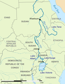
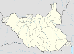
بحر الزراف، هو أحد أذرع النيل الأبيض في منطقة بحر الجبل، جنوب السودان، أفريقيا. ويوجد بالكامل في ولاية جونقلي.
. . . . . . . . . . . . . . . . . . . . . . . . . . . . . . . . . . . . . . . . . . . . . . . . . . . . . . . . . . . . . . . . . . . . . . . . . . . . . . . . . . . . . . . . . . . . . . . . . . . . . . . . . . . . . . . . . . . . . . . . . . . . . . . . . . . . . . . . . . . . . . . . . . . . . . . . . . . . . . . . . . . . . . . .
الاتجاه
يتشكل بحر الزراف في الجزء الجنوبي من مستنقعات منطقة السد كذراع من قطاع بحر الجبل في النيل الأبيض. وثمة قناتين اصطناعيتين تُعرفان بإسم اختصارات الزراف Zeraf Cuts حـُفـِرتا في 1910 و 1913[2] to connect the two rivers at 7°46′05″N 30°34′01″E / 7.768°N 30.567°E.[3] These canals divert some of the Jabal's flow, more than doubling the Zeraf's volume, with the intention of accelerating the flow to Egypt and thereby reducing the water "lost" to evaporation and transpiration in the swamps.[2]
من الاختصارين ينساب بحر الزراف شمالاً عبر منطقة بحر الزراف للصيد لنحو 280 كم. ونحو 100 كم من تلك المسافة is through continuous swamp with islands, transitioning further downstream to a well-defined channel with raised banks.[2] ويعود بحر الزراف لينضم إلى النيل الأبيض بالقرب من فنقاك الجديدة،[4] على بعد 80 كم أسفل النهر من بحيرة نو وعلى بعد 56 كم أعلى النهر من ملكال.[5]
انظر أيضا
المصادر
- ^ Action Contre la Faim (14 December 2006). "Sudan: Nutritional anthropometric survey, children under five years old - results summary Old Fangak Payam, Zeraf County, Jonglei State, Central Upper Nile". Retrieved 29 October 2013.
- ^ أ ب ت Newhouse, Frederic. The training of the upper Nile,. Sir I. Pitnam & sons, ltd.
- ^ Hughes, R. H.; Hughes, J. S. (1992). A directory of African wetlands ([Pbk. ed.]. ed.). Glan [u.a.]: IUCN [u.a.] ISBN 2880329493.
- ^ Openstreetmap (Map). Openstreetmap contributors. 2013.
- ^ "Bahr az-Zaraf". Encyclopædia Britannica Online Library Edition. Encyclopædia Britannica. Retrieved 2008-01-22.
وصلات خارجية
- Bahr el Zeraf (river), Getty Thesaurus of Geographic Names
- Baḩr az Zarāf, GEOnet Names Server
Coordinates: 9°24′45″N 31°9′52″E / 9.41250°N 31.16444°E{{#coordinates:}}: لا يمكن أن يكون هناك أكثر من وسم أساسي واحد لكل صفحة


