شمال كاليفورنيا
Northern California | |
|---|---|
 Clockwise: California State Capitol in Sacramento, Golden Gate Bridge, San Francisco skyline, San Jose skyline, Muir Woods National Monument, the northern California coast as seen from Muir Beach Overlook, view of the California side of Lake Tahoe and Natural Bridges State Beach in Santa Cruz. | |
 Northern California counties in red | |
| Country | |
| State | |
| Major Cities | San Jose San Francisco Sacramento Oakland Fresno Stockton Modesto Hayward Fremont Santa Rosa Sunnyvale San Rafael Redding Salinas Visalia Chico Eureka |
| Largest city | San Jose |
Northern California (colloquially known as NorCal; إسپانية: Norte de California) is the northern portion of the U.S. state of California. Spanning the state's northernmost 48 counties,[1][2] its main population centers include the San Francisco Bay Area (anchored by the cities of San Jose, San Francisco, and Oakland), the Greater Sacramento area (anchored by the state capital Sacramento), and the Metropolitan Fresno area (anchored by the city of Fresno). Northern California also contains redwood forests, along with the Sierra Nevada, including Yosemite Valley and part of Lake Tahoe, Mount Shasta (the second-highest peak in the Cascade Range after Mount Rainier in Washington), and most of the Central Valley, one of the world's most productive agricultural regions.
The 48-county definition is not used for the Northern California Megaregion, one of the 11 megaregions of the United States. The megaregion's area is instead defined from Metropolitan Fresno north to Greater Sacramento, and from the Bay Area east across Nevada state line to encompass the entire Lake Tahoe-Reno area.[3]
Evidence of Native American habitation in the area dates from at least 19,000 years ago[citation needed] and successive waves of arrivals led to one of the most densely populated areas of pre-Columbian North America. The arrival of European explorers from the early 16th to the mid-18th centuries did not establish European settlements in northern California. In 1770, the Spanish mission at Monterey was the first European settlement in the area, followed by other missions along the coast—eventually extending as far north as Sonoma County.[citation needed]
الوصف
.png&filetimestamp=20200821225251&)

المدن
-
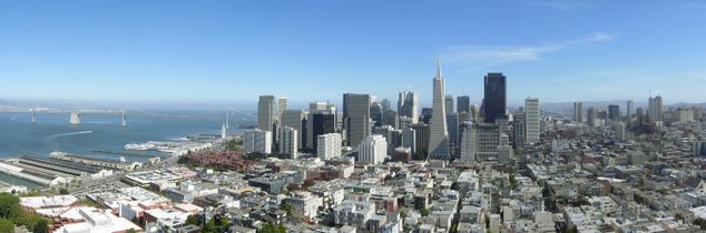 San Francisco, the second most populated city in Northern California and the leading economic center of the San Francisco Bay Area, its most populous metropolitan area (4.7 million residents) and the 14th largest in the United States.
 -
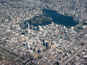 Oakland, the center of Northern California's African American community.
 -
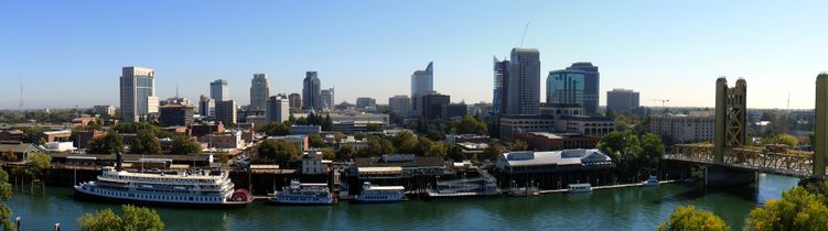 Sacramento, The capital city of California and the principal city of the Sacramento metropolitan area (2.5 million residents).
 -
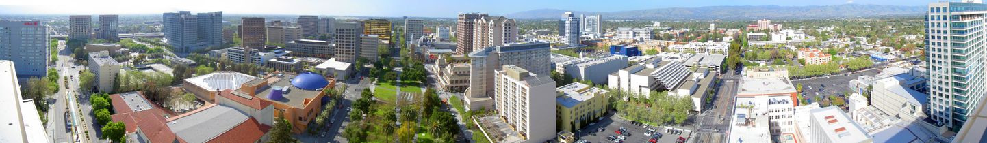 San Jose, the most populous city in Northern California and tenth largest in the United States, is the center of Silicon Valley, the preeminent region for technology in the US (1.9 million residents).
 -
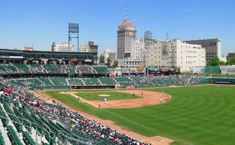 Downtown Fresno, third most populated city in northern California and fifth in California, from Chukchansi Park


.jpg&filetimestamp=20140209042402&)


المناخ

Northern California has warm or mild to cold climate, in which the Sierra gets snow in the late fall through winter and occasionally into spring. Summers are mild along the coast and generally warm and dry, while winters are cool and usually wet. The high temperatures range from 50s to 30s in the winters while summers temperature range is 90s to 60s or 50s, with highs well into the 100s for the Sacramento region. Snow covers the mountains (generally above 3000 feet) in mid January through February. Fog occurs infrequently or occurs normally in the west and coast, especially in the summer, creating some of the coolest summer conditions in North America.[citation needed]
Population
| التعداد | Pop. | ملاحظة | %± |
|---|---|---|---|
| 1850 | 86٬105 | — | |
| 1860 | 346٬714 | 302٫7% | |
| 1870 | 516٬089 | 48٫9% | |
| 1880 | 772٬778 | 49٫7% | |
| 1890 | 961٬628 | 24٫4% | |
| 1900 | 1٬147٬725 | 19٫4% | |
| 1910 | 1٬569٬141 | 36٫7% | |
| 1920 | 2٬003٬075 | 27٫7% | |
| 1930 | 2٬632٬273 | 31٫4% | |
| 1940 | 3٬066٬654 | 16٫5% | |
| 1950 | 4٬654٬248 | 51٫8% | |
| 1960 | 6٬318٬482 | 35٫8% | |
| 1970 | 7٬849٬575 | 24٫2% | |
| 1980 | 9٬359٬160 | 19٫2% | |
| 1990 | 11٬490٬926 | 22٫8% | |
| 2000 | 13٬234٬136 | 15٫2% | |
| 2010 | 14٬573٬946 | 10٫1% |
The population of the forty-eight counties of northern California has shown a steady increase over the years.[4][5]
Educational institutions
Northern California hosts a number of world-renowned universities including Stanford University and University of California, Berkeley. Top-tier public graduate schools include Boalt Hall and Hastings law schools and UC San Francisco, a top-ranked medical school, and UC Davis School of Veterinary Medicine, the largest vet school in the United States.
Public institutions
- Six University of California campuses:
- Eleven California State University campuses:
- A large number of local community colleges
Private institutions
(Partial list)
- Brandman University
- Dominican University
- Drexel University Sacramento
- Fresno Pacific University
- Holy Names University
- Mills College
- Northwestern Polytechnic University
- Pacific Union College
- Stanford University
- Santa Clara University
- St. Mary's College
- Simpson University
- Touro University California
- University of San Francisco
- University of the Pacific
- William Jessup University
- Academy of Art University
- Notre Dame de Namur University
- Samuel Merritt University
Research institutions
(Partial list)
- American Institute of Mathematics
- Bodega Marine Reserve
- Hopkins Marine Station
- Joint Genome Institute
- Lawrence Berkeley National Laboratory
- Lawrence Livermore National Laboratory
- Lick Observatory
- Long Marine Laboratory
- Monterey Bay Aquarium Research Institute
- NASA Ames Research Center
- Owens Valley Radio Observatory
- Pacific Institute
- Point Reyes Bird Observatory
- White Mountain Research Station
Counties
|
Regions
The following regions are entirely or partly within northern California:
Cities and towns in northern California with more than 50,000 inhabitants
|


_Dec_2009.jpg&filetimestamp=20200821225448&)


.JPG&filetimestamp=20200821225518&)


_2.JPG&filetimestamp=20200821225525&)


| City | Population (2010) |
|---|---|
| Alameda | 73,812 |
| Antioch | 102,372 |
| Berkeley | 112,580 |
| Brentwood | 51,481 |
| Chico | 86,187 |
| Citrus Heights | 83,301 |
| Clovis | 95,631 |
| Concord | 122,067 |
| Cupertino | 58,302 |
| Daly City | 101,123 |
| Davis | 65,622 |
| Elk Grove | 153,015 |
| Fairfield | 105,321 |
| Folsom | 72,203 |
| Fresno | 510,365 |
| Fremont | 214,089 |
| Hanford | 53,967 |
| Hayward | 144,186 |
| Livermore | 80,968 |
| Lodi | 62,134 |
| Madera | 61,416 |
| Manteca | 67,096 |
| Merced | 78,958 |
| Milpitas | 66,790 |
| Modesto | 201,165 |
| Mountain View | 74,066 |
| Napa | 76,915 |
| Novato | 51,904 |
| Oakland | 390,724 |
| Palo Alto | 64,403 |
| Petaluma | 57,941 |
| Pittsburg | 63,264 |
| Pleasanton | 70,285 |
| Porterville | 54,165 |
| Rancho Cordova | 64,776 |
| Redding | 89,861 |
| Redwood City | 76,815 |
| Richmond | 103,701 |
| Rocklin | 56,974 |
| Roseville | 118,788 |
| Sacramento | 466,488 |
| Salinas | 150,441 |
| San Francisco | 805,235 |
| San Jose | 945,942 |
| San Leandro | 84,950 |
| San Mateo | 97,207 |
| San Rafael | 57,713 |
| San Ramon | 72,148 |
| Santa Clara | 116,468 |
| Santa Cruz | 59,946 |
| Santa Rosa | 167,815 |
| South San Francisco | 63,632 |
| Stockton | 291,707 |
| Sunnyvale | 140,081 |
| Tracy | 82,922 |
| Tulare | 59,278 |
| Turlock | 68,549 |
| Union City | 69,516 |
| Vacaville | 92,428 |
| Vallejo | 115,942 |
| Visalia | 124,442 |
| Walnut Creek | 64,173 |
| Watsonville | 51,199 |
| Woodland | 55,468 |
| Yuba City | 64,925 |
Metropolitan areas
Northern California is home to three of the state's four extended metropolitan areas that are home to over three-fourths of the region's population as of the 2010 United States Census:[7]
| Metropolitan region | Population |
|---|---|
| San Francisco Bay Area | 7,468,390 |
| Greater Sacramento | 2,461,780 |
| Metropolitan Fresno | 1,081,315 |
Major business districts
The following are major central business districts:
النقل
انظر أيضاً المقالات:
انظر أيضاً التصنيفات:
المطارات في شمال كاليفورنيا

There are 11 airports in Northern California categorized as Primary Service Commercial airports by the FAA:[8]
| Airport | ID | City | Category | 2018 Enplanements |
|---|---|---|---|---|
| San Francisco International Airport | SFO | San Francisco | Large Hub | 27,794,154 |
| San Jose International Airport | SJC | San Jose | Medium Hub | 7,037,144 |
| Oakland International Airport | OAK | Oakland | Medium Hub | 6,687,963 |
| Sacramento International Airport | SMF | Sacramento | Medium Hub | 5,907,901 |
| Fresno Yosemite International Airport | FAT | Fresno | Small Hub | 853,538 |
| Charles M. Schulz–Sonoma County Airport | STS | Santa Rosa | Non Hub | 217,994 |
| Monterey Regional Airport | MRY | Monterey | Non Hub | 188,046 |
| Stockton Metropolitan Airport | SCK | Stockton | Non Hub | 99,258 |
| Arcata-Eureka Airport | ACV | Arcata | Non Hub | 69,604 |
| Redding Municipal Airport | RDD | Redding | Non Hub | 42,775 |
| Mammoth Yosemite Airport | MMH | Mammoth Lakes | Non Hub | 23,522 |
السكك الحديدية

- Bay Area Rapid Transit (BART) – commuter subway connecting most of the core Bay Area including San Francisco and Oakland with their suburbs with ongoing expansion to San Jose and Antioch
- Caltrain – commuter rail between San Francisco to Gilroy (south of San Jose)
- Muni Metro (San Francisco)
- VTA Light Rail (San Jose)
- Altamont Commuter Express (ACE) – commuter train connecting Stockton and the Central Valley with San Jose and the Bay Area
- Sacramento Regional Transit District light rail
- Amtrak:
- California Zephyr – connects Chicago to the Bay Area
- Capitol Corridor – San Jose to Auburn (eastern suburb of Sacramento)
- Coast Starlight – coastal train between Los Angeles and Seattle with northern California stops in San Jose, Oakland, and Sacramento
- San Joaquin – Central Valley train linking Bakersfield in the Central Valley to Sacramento and Oakland
هيئات النقل الرئيسية
- AC Transit
- Arcata and Mad River Transit System
- County Connection
- El Dorado Transit
- Eureka Transit Service
- Fairfield and Suisun Transit
- Fresno Area Express
- Golden Gate Transit
- Lake Transit
- Mendocino Transit Authority
- Monterey-Salinas Transit
- Porterville City Operated Local Transit
- Redwood Transit System
- SamTrans
- San Benito Express
- SF MUNI
- San Joaquin Regional Transit District
- Santa Clara Valley Transportation Authority (VTA)
- Santa Cruz Metro
- Solano Express
- SolTrans
- Sonoma County Transit
- Tri Delta Transit
- Visalia Transit
- VINE (Napa County)
عبارات النقل الرئيسية

الطرق السريعة
الطرق بين الولايات
 Interstate 80 (Eastshore Freeway/Lincoln Highway)
 Interstate 280 (Southern Embarcadero Freeway/Southern Freeway/Junipero Serra Freeway/Sinclair Freeway)
 Interstate 380
 Interstate 580 (Eastshore Freeway/MacArthur Freeway/Brown Freeway)
 Interstate 680 (Joseph P. Sinclair Freeway/Donald D. Doyle Highway/Blue Star Memorial Highway/Luther E. Gibson Freeway)
 Interstate 780
 Interstate 880 (Nimitz Freeway)
 Interstate 980 (Grove-Shafter Freeway)
 Interstate 238
 Interstate 205 (Robert T. Monagan Freeway)
 Interstate 5 (Golden State Freeway/West Side Freeway)
 Interstate 505
 Interstate 80 Business (Capital City Freeway)
طرق الولايات المتحدة

 U.S. Route 6
 U.S. Route 50 (El Dorado Freeway)
 U.S. Route 101 (South Valley Freeway/Bayshore Freeway/James Lick Freeway/Central Freeway/Redwood Highway/Michael J. Burns Freeway/Redwood Highway)
 U.S. Route 395
 U.S. Route 97
 U.S. Route 199


الطرق الولائية الرئيسية
 State Route 1 (Pacific Coast Highway/Cabrillo Highway)
 State Route 3
 State Route 4
 State Route 9
 State Route 12
 State Route 13 (Ashby Avenue/Tunnel Road/Warren Freeway)
 State Route 17
 State Route 24
 State Route 25
 State Route 29
 State Route 35 (Skyline Boulevard)
 State Route 36
 State Route 37 (Sears Point Tollway)
 State Route 41 (E.G. Lewis Highway, Yosemite Freeway, Southern Yosemite Highway, Wawona Road)
 State Route 43
 State Route 44
 State Route 46
 State Route 49 (Golden Chain Highway)
 State Route 58
 /
/ /
/ State Route 61 (Webster Tube/Posey Tube/Doolittle Drive/Davis Street)
 State Route 70
 State Route 82 (Monterey Highway/El Camino Real/Mission Street)
 State Route 84
 State Route 85 (Stevens Creek Freeway/West Valley Freeway/Norman Y. Mineta Highway/CHP Officer Scott M. Greenly Memorial Freeway)
 State Route 87 (Guadalupe Parkway)
 State Route 89
 State Route 92 (J. Arthur Younger Freeway/Jackson Street)
 State Route 99
 State Route 108
 State Route 113
 State Route 119
 State Route 120
 State Route 121
 State Route 132
 State Route 135
 State Route 140
 State Route 152
 State Route 154
 State Route 156
 State Route 160 (North Sacramento Freeway/River Road)
 State Route 166
 State Route 180
 /
/ State Route 185 (International Boulevard/East 14th Street/Mission Boulevard)
 State Route 198
 State Route 223
 State Route 236
 State Route 237
 State Route 238 (Mission Boulevard, Foothill Boulevard)
 State Route 254 (Avenue of the Giants)
 State Route 262 (Mission Boulevard)
 State Route 269
 State Route 275 (Tower Bridge Gateway)
 State Route 299
الاتصالات
Telephone Area Codes
- 209 — Northern San Joaquin Valley (Stockton, Modesto, and Merced).
- 341 — Overlay with 510
- 408 — Most of Santa Clara County (San Jose and Gilroy).
- 415 — San Francisco, Daly City, and Marin County. One of the three original Area Codes in California.
- 510 — Inner East Bay (Oakland, Berkeley, Richmond, and Fremont). Originally part of area code 415.
- 530 — A large northeastern section of the region including Tehama County, Shasta County, Lassen County, Yuba County, Sutter County, Butte County, and Nevada County. Split from area code 916 in 1997–1998.
- 559 — Southern San Joaquin Valley (Madera, Fresno, and Visalia).
- 628 — Overlay with 415.
- 650 — San Francisco Peninsula (San Mateo, Redwood City, and Palo Alto). Originally part of area code 415.
- 669 — Overlay with 408.
- 707 — The North Coast section of the region from Sonoma County to the Oregon border. Cities include Eureka, Ukiah, Santa Rosa, Napa, Vallejo and Fairfield.
- 831 — Monterey, San Benito and Santa Cruz Counties. Originally part of area code 408.
- 916/279 — Sacramento County and the Sacramento suburbs in western Placer and El Dorado Counties. One of the three original area codes in California, formerly covered all areas now within 530.
- 925 — Outer East Bay (Concord, Pittsburg, Walnut Creek, San Ramon, Pleasanton and Livermore). Originally part of area codes 415 and 510.[9]
الرياضة
الفرق الرياضية المحترفة في الروابط الرئيسية
فرق رياضية جامعية
مضامر رياضية
- Laguna Seca Raceway (motorsport)
- Sonoma Raceway (motorsport)
- Olympic Club (golf)
- Silverado Country Club (golf)
- TPC Harding Park (golf)
- TPC Stonebrae (golf)
أحداث رياضية
- Pac-12 Football Championship Game (college football)
- Emerald Bowl (college football)
- AT&T Pebble Beach Pro-Am (golf)
- Frys.com Open (golf)
- Swinging Skirts LPGA Classic (golf)
- Grand Prix of Sonoma (motorsport)
- Toyota/Save Mart 350 (motorsport)
- Monterey Sports Car Championships (motorsport)
- Superbike World Championship (motorsport)
See also
- Northern California Megaregion
- California megapolitan areas
- Central California
- History of California through 1899
- History of the west coast of North America
- Jefferson (proposed Pacific state)
- Megaregions of the United States
- Southern California
الهامش
- ^ Morgan, Neil (أبريل 19, 1963). "Westward Tilt: Northern California". Lodi News-Sentinel. Lodi, California. Retrieved سبتمبر 7, 2014.
- ^ John E. Kent, ed. (1917). Kent Guide Manual (Harrison Narcotic Law) and Progressional Registry. San Francisco: The Service Press. p. 6.
- ^ Metcalf, Gabriel; Terplan, Egon (نوفمبر–ديسمبر 2007). "The northern California megaregion". The Urbanist. San Francisco Planning and Urban Research Association. Retrieved نوفمبر 21, 2009.
- ^ "Historical census data by U.S. Census Bureau". Archived from the original on ديسمبر 31, 2003. Retrieved فبراير 6, 2019.
- ^ Bureau, U. S. Census. "U.S. Census website". United States Census Bureau. Retrieved فبراير 6, 2019.
- ^ Population figures are the most recent figures contained in the respective Wikipedia articles, in the List of cities in California (by population), or in the State of California, Department of Finance 2007 estimates Archived مارس 10, 2008 at the Wayback Machine.
- ^ Excerpted from 2010 United States Census
- ^ "Passenger Boarding (Enplanement) and All-Cargo Data for U.S. Airports – Airports". Faa.gov. Retrieved فبراير 6, 2019.
- ^ For current information, see nanpa.com, the North American Numbering Plan Administration site.
وصلات خارجية
- Articles with hatnote templates targeting a nonexistent page
- Missing redirects
- Short description is different from Wikidata
- Use mdy dates from August 2018
- Pages using infobox settlement with unknown parameters
- Pages using infobox settlement with no coordinates
- Articles containing إسپانية-language text
- Pages using Lang-xx templates
- Articles with unsourced statements from July 2019
- Articles with unsourced statements from May 2020
- Pages with empty portal template
- Articles with Curlie links
- Portal-inline template with redlinked portals
- شمال كاليفورنيا
- Megapolitan areas of California
- مناطق كاليفورنيا