دزفول
دزفول
Dezful | |
|---|---|
مدينة | |
 | |
| الإحداثيات: 32°22′57″N 48°24′07″E / 32.38250°N 48.40194°E | |
| البلد | |
| محافظة | خوزستان |
| المقاطعة | دزفول |
| بخش | المركزي |
| المنسوب | 150 m (490 ft) |
| التعداد (2016 Census) | |
| • Urban | 264٬709 [1] |
| منطقة التوقيت | UTC+3:30 (IRST) |
| • الصيف (التوقيت الصيفي) | UTC+4:30 (IRDT) |
| مفتاح الهاتف | 061 |
دزفول وقد أبدل الفرس اسمها العربي إلى دزفول أو دسبول ، هي مدينة إيرانية جنوبية تقع في محافظة خوزستان على سفوح جبال زاگروس وعلى ضفة نهر ديز، وأراضيها عبارة عن تلال متوازية. عدد سكانها 256,927 نسمة حسب احصاء 2005.
التاريخ
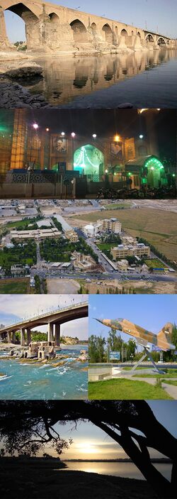
Dezful is one of the oldest cities in the Khuzestan province. According to Walther Hinz excavations, Awan (capital of the first Elam empire) was located in Dezful. The bridge was built during the reign of Shapur I who used Roman prisoners of war after the Battle of Edessa to build the bridge.[2]
الجغرافيا
المناخ
Dezful has a hot semi-arid climate (Köppen climate classification BSh) with extremely hot summers and mild winters. Rainfall is higher than most of southern Iran, but is almost exclusively confined to the period from November to April, though on occasions it can exceed 250 ميليمتر (9.8 in) per month or 600 ميليمتر (24 in) per year.[3]
| بيانات المناخ لـ دزفول | |||||||||||||
|---|---|---|---|---|---|---|---|---|---|---|---|---|---|
| الشهر | ينا | فب | مار | أبر | ماي | يون | يول | أغس | سبت | أكت | نوف | ديس | السنة |
| القصوى القياسية °س (°ف) | 28.0 (82.4) |
29.0 (84.2) |
36.0 (96.8) |
40.5 (104.9) |
46.5 (115.7) |
50.0 (122.0) |
53.6 (128.5) |
52.0 (125.6) |
48.0 (118.4) |
43.0 (109.4) |
35.0 (95.0) |
29.0 (84.2) |
53.6 (128.5) |
| متوسط القصوى اليومية °س (°ف) | 17.2 (63.0) |
19.6 (67.3) |
24.1 (75.4) |
30.0 (86.0) |
37.5 (99.5) |
43.7 (110.7) |
46.0 (114.8) |
44.9 (112.8) |
41.7 (107.1) |
34.8 (94.6) |
26.2 (79.2) |
19.3 (66.7) |
32.1 (89.8) |
| المتوسط اليومي °س (°ف) | 10.8 (51.4) |
13.2 (55.8) |
17.3 (63.1) |
22.8 (73.0) |
29.9 (85.8) |
35.1 (95.2) |
37.0 (98.6) |
35.8 (96.4) |
32.0 (89.6) |
25.6 (78.1) |
17.9 (64.2) |
12.5 (54.5) |
24.2 (75.5) |
| متوسط الدنيا اليومية °س (°ف) | 5.3 (41.5) |
6.8 (44.2) |
10.0 (50.0) |
14.7 (58.5) |
20.5 (68.9) |
23.8 (74.8) |
26.2 (79.2) |
25.5 (77.9) |
21.1 (70.0) |
16.2 (61.2) |
10.8 (51.4) |
6.8 (44.2) |
15.6 (60.2) |
| الصغرى القياسية °س (°ف) | −9 (16) |
−4.0 (24.8) |
−2 (28) |
3.0 (37.4) |
10.0 (50.0) |
16.0 (60.8) |
19.0 (66.2) |
16.5 (61.7) |
10.0 (50.0) |
6.0 (42.8) |
1.0 (33.8) |
−2 (28) |
−9 (16) |
| متوسط تساقط الأمطار mm (inches) | 100.6 (3.96) |
60.0 (2.36) |
50.2 (1.98) |
34.5 (1.36) |
9.2 (0.36) |
0.0 (0.0) |
0.2 (0.01) |
0.0 (0.0) |
0.0 (0.0) |
7.4 (0.29) |
39.1 (1.54) |
83.2 (3.28) |
384.4 (15.14) |
| Average rainy days | 9.9 | 8.1 | 8.1 | 6.5 | 3.0 | 0.0 | 0.1 | 0.0 | 0.0 | 2.1 | 6.2 | 8.0 | 52 |
| متوسط الرطوبة النسبية (%) | 75 | 68 | 59 | 49 | 32 | 22 | 24 | 28 | 29 | 40 | 59 | 73 | 47 |
| Mean monthly ساعات سطوع الشمس | 131.6 | 158.4 | 192.3 | 217.7 | 272.5 | 325.6 | 322.7 | 317.0 | 291.3 | 234.8 | 158.2 | 121.9 | 2٬744 |
| Source: NOAA (1961-1990) [4] | |||||||||||||
الاقتصاد
Dezfūl is the primary commercial center for northern Khuzestan and one of the main producers of agricultural products in Iran. Dezful is also a market for the agricultural products of Lorestan province. The city also contains a large cotton textile mill and many small- and medium-scale industries. The Dez Dam, 203 m (666 ft) high, completed in 1963, is 32 km (20 mi) upstream from Dezful; the dam provides water and electricity for the city, as well as irrigation for nearby sugarcane farms.
الزراعة
Agriculture around Dezful was modernized in the mid-1960s by an Iranian-American joint venture company. Flowers and citrus fruits from Dezful are held in high regard in the country.[citation needed] Also popular are yogurt and cream from local buffalos. Various vegetables, fruit and grains are grown in Dezful. Meat, poultry and fish are also produced.
قاعدة ومطار دزفول وحدتي
Dezful Vahdati Air Force Base is the 4th IRIAF Air Force base and it is operational for F-5A, E, F and B fighters. The base was bombarded and shelled by the Iraqi Air Force and Iraqi Army during the early stages of the Iran–Iraq War. There is an annual air show for the remembrance of war heroes at the beginning of the Iranian New Year (Nowruz). Held from March 21 to April 4, it is the only military air show in Iran.[citation needed]
The Dezful air force base is also used for domestic passenger flights. There have been occasional bans of passenger flights in Dezful air base because of military security matters in the past 20 years, but finally, based on an agreement between military commanders and Dezful civil governors, regular daily flights were established at the end of 2007 by two domestic airlines, Iran Air Tour and Aseman.[citation needed] There are currently at least one or two flights from this base (which is now called Dezful Airport) to Tehran and back from Tehran every day.
البلدات التوأم - المدن الشقيقة
انظر أيضاً
- معركة دزفول
- مرتضى أنصاري، فقيه شيعي شهير
- غلام علي رشيد، قائد عسكري من دزفول
المصادر
- ^ https://www.amar.org.ir/english
- ^ Hartung, Fritz; Kuros, Gh. R. (1987), "Historische Talsperren im Iran", in Garbrecht, Günther, Historische Talsperren, 1, Stuttgart: Verlag Konrad Wittwer, pp. 221–274 (232), ISBN 3-87919-145-X
- ^ "اداره کل هواشناسی استان چهارمحال و بختیاری". www.chaharmahalmet.ir. Retrieved 2 April 2018.
- ^ "Dezful Climate Normals 1961-1990". National Oceanic and Atmospheric Administration. Retrieved December 28, 2012.
- ^ https://www.alahwazvoice.org/
- ^ https://arabic.alahwaz.info/
- ^ "Archived copy". Archived from the original on 2015-06-10. Retrieved 2013-11-16.
{{cite web}}: CS1 maint: archived copy as title (link)
وصلات خارجية
- Pages using gadget WikiMiniAtlas
- Short description is different from Wikidata
- Coordinates on Wikidata
- Pages using infobox settlement with unknown parameters
- Articles with unsourced statements from July 2010
- Articles with unsourced statements from January 2013
- أماكن مأهولة في مقاطعة دزفول
- مدن محافظة خوزستان


