خط العرض 54° شمالاً

Line across the Earth
54°
خط العرض 54 شمال

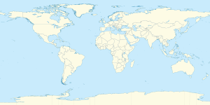
خط العرض 54 شمالًا (إنگليزية: 54th parallel north) هي دائرة عرض بزاوية 54 درجة شمال خط الاستواء. تمر دائرة العرض 54° شمالاً عبر أفريقيا، المحيط الهندي، جنوب آسيا، جنوب شرق آسيا، المحيط الهادي، أمريكا الوسطى، امريكا الجنوبية والمحيط الأطلسي.

عند خط العرض هذا، تكون الشمس مرئية لمدة17 ساعة و 9 دقائق أثناء الانقلاب الصيفي، و7 ساعات و 22 دقيقة أثناء الانقلاب الشتوي.[1]

. . . . . . . . . . . . . . . . . . . . . . . . . . . . . . . . . . . . . . . . . . . . . . . . . . . . . . . . . . . . . . . . . . . . . . . . . . . . . . . . . . . . . . . . . . . . . . . . . . . . . . . . . . . . . . . . . . . . . . . . . . . . . . . . . . . . . . . . . . . . . . . . . . . . . . . . . . . . . . . . . . . . . . . .

حول العالم

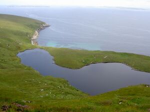
The 54th parallel passes through Lough Nakeeroge on Achill Island
R178 road on the bridge of behind Dundalk South signal cabin almost follows the 54th parallel.
Level crossing in Driffield, East Riding of Yorkshire

بدءاً من خط الزوال الرئيسي، في الاتجاه الشرقي، يمر خط العرض 12° شمالاً عبر:

الإحداثيات البلد أو الإقليم أو البحر ملاحظات
54°0′N 0°0′E / 54.000°N 0.000°E / 54.000; 0.000 (Prime Meridian) North Sea
54°0′N 8°52′E / 54.000°N 8.867°E / 54.000; 8.867 (Germany) Flag of Germany.svg ألمانيا State of Schleswig-Holstein
54°0′N 10°47′E / 54.000°N 10.783°E / 54.000; 10.783 (Baltic Sea) Baltic Sea Bay of Lübeck
54°0′N 11°1′E / 54.000°N 11.017°E / 54.000; 11.017 (Germany) Flag of Germany.svg ألمانيا State of Mecklenburg-Vorpommern
54°0′N 11°12′E / 54.000°N 11.200°E / 54.000; 11.200 (Baltic Sea) Baltic Sea Bay of Wismar
54°0′N 11°23′E / 54.000°N 11.383°E / 54.000; 11.383 (Germany) Flag of Germany.svg ألمانيا Island of Poel, mainland, and island of Usedom
54°0′N 14°6′E / 54.000°N 14.100°E / 54.000; 14.100 (Baltic Sea) Baltic Sea
54°0′N 14°38′E / 54.000°N 14.633°E / 54.000; 14.633 (Poland) Flag of Poland.svg بولندا Island of Wolin, and mainland
54°0′N 23°29′E / 54.000°N 23.483°E / 54.000; 23.483 (Lithuania) Flag of Lithuania.svg لتوانيا Alytus County
54°0′N 24°36′E / 54.000°N 24.600°E / 54.000; 24.600 (Belarus) Flag of Belarus.svg بلاروس For about 7 km (4.3 mi)
54°0′N 24°43′E / 54.000°N 24.717°E / 54.000; 24.717 (Lithuania) Flag of Lithuania.svg لتوانيا For about 8 km (5.0 mi)
54°0′N 24°50′E / 54.000°N 24.833°E / 54.000; 24.833 (Belarus) Flag of Belarus.svg بلاروس Passing just north of Minsk
54°0′N 31°52′E / 54.000°N 31.867°E / 54.000; 31.867 (Russia) Flag of Russia.svg روسيا Smolensk Oblast
54°0′N 61°15′E / 54.000°N 61.250°E / 54.000; 61.250 (Kazakhstan) كازاخستان كازاخستان Kostanay Region
54°0′N 61°34′E / 54.000°N 61.567°E / 54.000; 61.567 (Russia) Flag of Russia.svg روسيا For about 5 km (3.1 mi)
54°0′N 61°39′E / 54.000°N 61.650°E / 54.000; 61.650 (Kazakhstan) كازاخستان كازاخستان For about 7 km (4.3 mi)
54°0′N 61°46′E / 54.000°N 61.767°E / 54.000; 61.767 (Russia) Flag of Russia.svg روسيا For about 4 km (2.5 mi)
54°0′N 61°49′E / 54.000°N 61.817°E / 54.000; 61.817 (Kazakhstan) كازاخستان كازاخستان For about 6 km (3.7 mi)
54°0′N 61°54′E / 54.000°N 61.900°E / 54.000; 61.900 (Russia) Flag of Russia.svg روسيا For about 8 km (5.0 mi)
54°0′N 62°1′E / 54.000°N 62.017°E / 54.000; 62.017 (Kazakhstan) كازاخستان كازاخستان
54°0′N 62°25′E / 54.000°N 62.417°E / 54.000; 62.417 (Russia) Flag of Russia.svg روسيا For about 14 km (8.7 mi)
54°0′N 62°38′E / 54.000°N 62.633°E / 54.000; 62.633 (Kazakhstan) كازاخستان كازاخستان
54°0′N 72°24′E / 54.000°N 72.400°E / 54.000; 72.400 (Russia) Flag of Russia.svg روسيا For about 19 km (12 mi)
54°0′N 72°42′E / 54.000°N 72.700°E / 54.000; 72.700 (Kazakhstan) كازاخستان كازاخستان
54°0′N 73°4′E / 54.000°N 73.067°E / 54.000; 73.067 (Russia) Flag of Russia.svg روسيا
54°0′N 73°31′E / 54.000°N 73.517°E / 54.000; 73.517 (Kazakhstan) كازاخستان كازاخستان For about 15 km (9.3 mi)
54°0′N 73°44′E / 54.000°N 73.733°E / 54.000; 73.733 (Russia) Flag of Russia.svg روسيا
54°0′N 75°29′E / 54.000°N 75.483°E / 54.000; 75.483 (Kazakhstan) كازاخستان كازاخستان
54°0′N 76°32′E / 54.000°N 76.533°E / 54.000; 76.533 (Russia) Flag of Russia.svg روسيا Passing through Lake Baikal
54°0′N 137°30′E / 54.000°N 137.500°E / 54.000; 137.500 (Sea of Okhotsk) Sea of Okhotsk
54°0′N 138°46′E / 54.000°N 138.767°E / 54.000; 138.767 (Russia) Flag of Russia.svg روسيا
54°0′N 140°12′E / 54.000°N 140.200°E / 54.000; 140.200 (Sea of Okhotsk) Sea of Okhotsk Sakhalin Gulf
54°0′N 142°36′E / 54.000°N 142.600°E / 54.000; 142.600 (Russia) Flag of Russia.svg روسيا Island of Sakhalin
54°0′N 142°55′E / 54.000°N 142.917°E / 54.000; 142.917 (Sea of Okhotsk) Sea of Okhotsk
54°0′N 155°53′E / 54.000°N 155.883°E / 54.000; 155.883 (Russia) Flag of Russia.svg روسيا Kamchatka Peninsula
54°0′N 159°56′E / 54.000°N 159.933°E / 54.000; 159.933 (Pacific Ocean) Pacific Ocean
54°0′N 169°30′E / 54.000°N 169.500°E / 54.000; 169.500 (Bering Sea) Bering Sea
54°0′N 166°47′W / 54.000°N 166.783°W / 54.000; -166.783 (United States)  الولايات المتحدة Alaska - Unalaska Island
54°0′N 166°21′W / 54.000°N 166.350°W / 54.000; -166.350 (Pacific Ocean) Pacific Ocean Gulf of Alaska - passing just north of Unalga Island, and just south of Akutan Island, Rootok Island, Avatanak Island and Tigalda Island, Alaska,  الولايات المتحدة
54°0′N 133°6′W / 54.000°N 133.100°W / 54.000; -133.100 (Canada) Flag of Canada.svg كندا British Columbia - Graham Island
54°0′N 131°41′W / 54.000°N 131.683°W / 54.000; -131.683 (Hecate Strait) Hecate Strait
54°0′N 130°40′W / 54.000°N 130.667°W / 54.000; -130.667 (Canada) Flag of Canada.svg كندا British Columbia - Porcher Island, Kennedy Island and the mainland - passing through the port of Kitimat and 7 km (4.3 mi) north of Prince George
Alberta
Saskatchewan
Manitoba
Ontario
54°0′N 82°14′W / 54.000°N 82.233°W / 54.000; -82.233 (James Bay) James Bay
54°0′N 78°58′W / 54.000°N 78.967°W / 54.000; -78.967 (Canada) Flag of Canada.svg كندا Quebec
Newfoundland and Labrador
54°0′N 57°16′W / 54.000°N 57.267°W / 54.000; -57.267 (Atlantic Ocean) Atlantic Ocean
54°0′N 10°12′W / 54.000°N 10.200°W / 54.000; -10.200 (Ireland) Flag of Ireland.svg أيرلندا Achill Island
Irish mainland:
54°0′N 6°20′W / 54.000°N 6.333°W / 54.000; -6.333 (Dundalk Bay) Dundalk Bay For about 4.4 km (2.7 mi)
54°0′N 6°16′W / 54.000°N 6.267°W / 54.000; -6.267 (Ireland) Flag of Ireland.svg أيرلندا Cooley Peninsula (12 km (7.5 mi))
54°0′N 6°7′W / 54.000°N 6.117°W / 54.000; -6.117 (Irish Sea) Irish Sea Passing just south of the  جزيرة مان
54°0′N 2°54′W / 54.000°N 2.900°W / 54.000; -2.900 (United Kingdom) Flag of the United Kingdom.png المملكة المتحدة England inc. Harrogate at 54°0′N 1°30′W / 54.000°N 1.500°W / 54.000; -1.500 (Harrogate)
54°0′N 0°13′W / 54.000°N 0.217°W / 54.000; -0.217 (Irish Sea) North Sea


انظر ايضا

المصادر

  1. ^ "Duration of Daylight/Darkness Table for One Year". Archived from the original on 12 أكتوبر 2019.