إرڤاين، كاليفورنيا
(تم التحويل من إرفاين، كاليفورنيا)
إرڤاين، كاليفورنيا Irvine, California | |
|---|---|
|
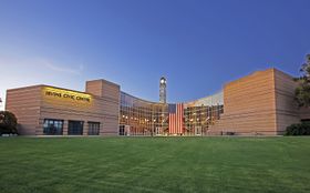
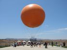
تجاه عقارب الساعة من أعلى: مركز إرڤاين المدني، ملاذ سان جواكين للحياة البرية، جامعة كاليفورنيا، إرڤاين، ركوب المنطاد في منتزه أورنج كاونتي گريت، "العجلة العملاقة" في مركز إرڤاين سپكترم | |
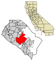
 موقع إرڤاين في مقاطعة أورانج، كاليفورنيا. | |
| الإحداثيات: 33°40′10″N 117°49′23″W / 33.66944°N 117.82306°W[2] | |
| البلد | |
| الولاية | |
| المقاطعة | |
| دُمجت | 28 ديسمبر 1971[3] |
| السمِيْ | جيمس إرڤاين |
| الحكومة | |
| • النوع | المجلس-المدير[4] |
| • العمدة | دونالد پ. واگنر |
| • نائب العمدة | لين سكوت |
| • أعضاء مجلس المدينة [6] | مليسا فوكس جفري لالواي كرستينا شيا |
| • مدير المدينة | شون جويس [5] |
| المساحة | |
| • الإجمالي | 65٫92 ميل² (170٫74 كم²) |
| • البر | 65٫58 ميل² (169٫86 كم²) |
| • الماء | 0٫34 ميل² (0٫89 كم²) 0.52% |
| المنسوب | 56 ft (17 m) |
| التعداد | |
| • الإجمالي | 212٬375 |
| • Estimate (2018)[9] | 276٬176 |
| • الترتيب | 3rd in Orange County 16th in California 75th in the United States |
| • الكثافة | 4٬211٫28/sq mi (1٬566٫75/km2) |
| صفة المواطن | إرڤيني |
| منطقة التوقيت | UTC−8 (الهادي) |
| • الصيف (التوقيت الصيفي) | UTC−7 (PDT) |
| الرمود البريدية[10] | 92602–92604, 92606, 92612, 92614, 92616–92620, 92623, 92650, 92697 |
| رموز المنطقة | 949, 657/714 |
| رمز FIPS | 06-36770[11] |
| GNIS feature IDs | 1660804, 2410116 |
| نطاق النفوذ | 74 ميل[12] |
| الموقع الإلكتروني | cityofirvine |
| الزهرة | زنبق النيل[12] |
|---|---|
| الحشرة | الفراشة الغربية خطافية الذيل[12] |
| الشجرة | الكافور[12] |
| الخضروات | الهليون[12] |
إرڤاين (Irvine؛ /ˈɜːrvaɪn/ UR-vyn)، هي مدينة في ولاية كاليفورنيا في الولايات المتحدة الأمريكية. توجد في إرڤاين إحدى فروع جامعة كاليفورنيا. بدأت شركة إرڤاين في تطوير المنطقة في الستينيات ودُمجت المنطقة رسمياً في 28 ديسمبر 1971. تبلغ مساحتها 170 كم²[13] وعدد سكانها 212.375 حسب تعداد 2010؛ في 2018 قدرت ادارة مالية كاليفورنيا عدد سكان المدينة بـ276.176 نسمة.[9]
المناخ
| بيانات المناخ لـ إرڤاين رنش، إرڤاين، كاليفورنيا | |||||||||||||
|---|---|---|---|---|---|---|---|---|---|---|---|---|---|
| الشهر | ينا | فب | مار | أبر | ماي | يون | يول | أغس | سبت | أكت | نوف | ديس | السنة |
| القصوى القياسية °ف (°س) | 94 (34) |
92 (33) |
98 (37) |
106 (41) |
105 (41) |
109 (43) |
109 (43) |
110 (43) |
111 (44) |
108 (42) |
105 (41) |
97 (36) |
111 (44) |
| متوسط القصوى اليومية °ف (°س) | 67.7 (19.8) |
68.4 (20.2) |
69.3 (20.7) |
73.2 (22.9) |
75.4 (24.1) |
78.7 (25.9) |
84.4 (29.1) |
84.8 (29.3) |
84.1 (28.9) |
79.3 (26.3) |
73.2 (22.9) |
67.8 (19.9) |
75.5 (24.2) |
| متوسط الدنيا اليومية °ف (°س) | 41.1 (5.1) |
43.2 (6.2) |
45.4 (7.4) |
48.3 (9.1) |
53.1 (11.7) |
56.7 (13.7) |
60.3 (15.7) |
60.7 (15.9) |
58.4 (14.7) |
53.4 (11.9) |
45.2 (7.3) |
40.4 (4.7) |
50.5 (10.3) |
| الصغرى القياسية °ف (°س) | 18 (−8) |
25 (−4) |
26 (−3) |
31 (−1) |
34 (1) |
40 (4) |
44 (7) |
43 (6) |
39 (4) |
29 (−2) |
25 (−4) |
24 (−4) |
18 (−8) |
| متوسط تساقط الأمطار inches (mm) | 2.92 (74) |
3.31 (84) |
2.14 (54) |
0.94 (24) |
0.28 (7.1) |
0.12 (3.0) |
0.05 (1.3) |
0.05 (1.3) |
0.20 (5.1) |
0.74 (19) |
1.17 (30) |
2.40 (61) |
14.32 (363.8) |
| Source: NOAA[14] | |||||||||||||
الديموغرافيا
| ||||||||||||||||||||||||||||||||
في 2016، أصبحت إرڤاين أكبر مدينة في الولايات المتحدة القارية من حيث التعددية الأمريكية الآسيوية، التي تشكل حوالي 45% من سكان المدينة.[17]
| الملف الديموغرافي | 1980[18] | 1990[18] | 2000[19] | 2010[20] |
|---|---|---|---|---|
| بيض | 87.8% | 77.9% | 61.1% | 50.5% |
| —غير هسپان | 84.5% | 73.9% | 57% | 45.1% |
| أمريكان أفارقة أو سود | 1.5% | 1.8% | 1.5% | 1.8% |
| هسپان أو لاتينيون (من أي عرقية) | 5.8% | 6.3% | 7.4% | 9.2% |
| آسيويون | 7.8% | 18.1% | 29.8% | 45.1% |
المدن الشقيقة
إرڤاين على شقاقة مع أربع مدن:[21]
المصادر
- ^ "Municode Library". library.municode.com.
- ^ أ ب "Irvine". نظام معلومات الأسماء الجغرافية، المسح الجيولوجي الأمريكي. Retrieved November 6, 2014.
- ^ "California Cities by Incorporation Date". California Association of Local Agency Formation Commissions. Archived from the original (Word) on November 3, 2014. Retrieved August 25, 2014.
{{cite web}}: Unknown parameter|deadurl=ignored (|url-status=suggested) (help) - ^ "City Charter". City of Irvine. Archived from the original on أكتوبر 7, 2014. Retrieved أكتوبر 9, 2014.
{{cite web}}: Unknown parameter|deadurl=ignored (|url-status=suggested) (help) - ^ "City Manager". City of Irvine. Archived from the original on أكتوبر 26, 2014. Retrieved أكتوبر 12, 2014.
{{cite web}}: Unknown parameter|deadurl=ignored (|url-status=suggested) (help) - ^ "City Council". City of Irvine. Archived from the original on أبريل 3, 2015. Retrieved ديسمبر 14, 2016.
{{cite web}}: Unknown parameter|deadurl=ignored (|url-status=suggested) (help) - ^ "2016 U.S. Gazetteer Files". United States Census Bureau. Retrieved July 19, 2017.
- ^ E-1 Population Estimates for Cities, Counties, and the State — January 1, 2015 and 2016, May 1, 2016, http://www.ocregister.com/articles/irvine-660773-state-population.html
- ^ أ ب E-1 Population Estimates for Cities, Counties, and the State — January 1, 2017 and 2018, May 1, 2018, http://www.dof.ca.gov/Forecasting/Demographics/Estimates/E-1/
- ^ "ZIP Code(tm) Lookup". United States Postal Service. Retrieved November 28, 2014.
- ^ "American FactFinder". United States Census Bureau. Archived from the original on September 11, 2013. Retrieved January 31, 2008.
{{cite web}}: Unknown parameter|deadurl=ignored (|url-status=suggested) (help) - ^ أ ب ت ث ج "Demographics Information". City of Irvine. Archived from the original on March 17, 2015. Retrieved January 3, 2017.
{{cite web}}: Unknown parameter|deadurl=ignored (|url-status=suggested) (help) - ^ "City of Irvine Website – History of the City". Ci.irvine.ca.us. Archived from the original on December 3, 2010. Retrieved January 28, 2011.
{{cite web}}: Unknown parameter|deadurl=ignored (|url-status=suggested) (help) - ^ (NCEI), National Centers for Environmental Information. "1981-2010 Normals - Data Tools - Climate Data Online (CDO) - National Climatic Data Center (NCDC)". www.weather.com. Retrieved October 21, 2017.
- ^ "Population and Housing Unit Estimates". Retrieved June 9, 2017.
- ^ "Census of Population and Housing". Census.gov. Archived from the original on May 12, 2015. Retrieved June 4, 2015.
{{cite web}}: Unknown parameter|deadurl=ignored (|url-status=suggested) (help) - ^ Asian influx sparks Irvine's evolution as a multinational city, Orange County Register (September 18, 2016).
- ^ أ ب "California — Race and Hispanic Origin for Selected Cities and Other Places: Earliest Census to 1990". U.S. Census Bureau. Archived from the original on August 6, 2012. Retrieved April 16, 2012.
{{cite web}}: Unknown parameter|deadurl=ignored (|url-status=suggested) (help) - ^ "2000 Census of Irvine, California". Retrieved January 5, 2016.
- ^ خطأ استشهاد: وسم
<ref>غير صحيح؛ لا نص تم توفيره للمراجع المسماةdemographics - ^ "Sister Cities Program". City of Irvine. Retrieved November 2, 2015.
وصلات خارجية
| Find more about إرڤاين، كاليفورنيا at Wikipedia's sister projects | |
| Definitions from Wiktionary | |
| Media from Commons | |
| Quotations from Wikiquote | |
| Source texts from Wikisource | |
| Textbooks from Wikibooks | |
| Travel guide from Wikivoyage | |
| Learning resources from Wikiversity | |
مجموعات أرشيفية
- Guide to the East Irvine Historic Resources Documentation Photographs, 1988. Special Collections and Archives, The UC Irvine Libraries, Irvine, California.
- Guide to the George Leidal Collection on the City of Irvine. Special Collections and Archives, The UC Irvine Libraries, Irvine, California.
أخرى
?
تصنيفات:
- Pages using gadget WikiMiniAtlas
- CS1 errors: unsupported parameter
- Short description is different from Wikidata
- Coordinates on Wikidata
- Pages using US Census population needing update
- Portal templates with default image
- Official website different in Wikidata and Wikipedia
- Portal-inline template with redlinked portals
- Pages with empty portal template
- Pages using columns-list with unknown parameters
- إرڤاين، كاليفورنيا
- مدن مقاطعة أورانج، كاليفورنيا
- مدن مخططة في الولايات المتحدة
- أماكن مأهولة تأسست في 1971
- مدن وبلدات مدمجة في كاليفورنيا
- تأسيسات 1971 في كاليفورنيا
- مدن كاليفورنيا


