سوساليتو، كاليفورنيا
سوساليتو Sausalito | |
|---|---|
 سوساليتو من بردجواي، شارع بوسط المدينة. | |
 موقع سوساليتو في مقاطعة مارين وولاية كاليفورنيا | |
 سوساليتو الموقع في الولايات المتحدة  سوساليتو سوساليتو (Northern California)  سوساليتو سوساليتو (كاليفورنيا)  سوساليتو سوساليتو (الولايات المتحدة) | |
| الإحداثيات: 37°51′33″N 122°29′07″W / 37.85917°N 122.48528°W | |
| البلد | الولايات المتحدة |
| الولاية | كاليفورنيا |
| المقاطعة | مارين |
| أُدمجت | 4 سبتمبر 1893[1] |
| الحكومة | |
| • العمدة | توماس تيودورس[2] |
| • سناتور الولاية | Mike McGuire (د)[3] |
| • عضو المجلس | Marc Levine (د)[3] |
| • ن.أ. | Jared Huffman (د)[4] |
| • المشرف | المنطقة 3 تشارلز مكگلاشان |
| المساحة | |
| • الإجمالي | 2٫257 ميل² (5٫846 كم²) |
| • البر | 1٫771 ميل² (4٫586 كم²) |
| • الماء | 0٫486 ميل² (1٫259 كم²) 21.54% |
| المنسوب | 10 ft (3 m) |
| التعداد (2010) | |
| • الإجمالي | 7٬061 |
| منطقة التوقيت | UTC-8 (م.ت.) |
| • الصيف (التوقيت الصيفي) | UTC-7 (PDT) |
| الرمز البريدي | 94965–94966 |
| مفتاح الهاتف | 415 |
| FIPS code | 06-70364 |
| GNIS feature IDs | 277597, 2411834 |
| الموقع الإلكتروني | www |
سسوساليتو Sausalito، هي مدينة في مقاطعة مارين، كاليفورنيا، منطقة خليج سان فرانسيسكو. تقع على بعد 13 كم جنوب-جنوب شرق سان رافايل،[7] على إرتفاع 4 متر.[6] في تعداد 2010 كان عدد سكانها 7.081 نسمة. يقع التجمع بالقرب من الطرف الشمالي لجسر البوابة الذهبية، وقبل بناء الجسر كانت المدينة محطة أخيرة للمرور بالسكك الحديدية، السيارات والعبارات. شهدت المدينة تطوراً سريعاً كمركز لبناء السفن أثناء الحرب العالمية الثانية، الطابع الصناعي للمدينة أفسح لها الكريق في سنوات ما بعد الحرب لتشتهر كمركز للثروات والفنون.
التسمية
The name of Sausalito comes from the Spanish sauzalito, meaning "small willow grove", from sauce "willow" + collective derivative -al meaning "place of abundance" + diminutive suffix -ito; with orthographic corruption from z to s due to seseo. Early variants of the name included Saucelito, San Salita, San Saulito, San Salito, Sancolito, Sancilito, Sousolito, Sousalita, Sousilito, Salcido, Sausilito, and Sauz Saulita.[7]
It is sometimes claimed[ممن؟] that Sausalito was named for the district in Valparaíso, Chile, where the bandit Joaquín Murrieta was born. Murrieta was the leader of bandits who settled at the northern end of the future Golden Gate Bridge after being banned from San Francisco in the bandit wars. However, this theory cannot be true because Murrieta was from Mexico, not Chile, and because he did not arrive in California until the Gold Rush around 1849.[8] The Rancho Saucelito had already been granted to William Richardson in 1838.[9]
الجغرافيا
Located at 37°51′33″N 122°29′07″W / 37.85917°N 122.48528°W,[6] Sausalito encompasses both steep, wooded hillside and shoreline tidal flats. According to the United States Census Bureau, the city has a total area of 2.2 ميل مربع (5.7 km2). Notably, only 1.8 ميل مربع (4.7 km2) of it is land. A full 21.54% of the city (0.5 square miles, or 1.3 km2) is under water, and has been so since its founding in 1868. Prominent geographic features associated with Sausalito include Richardson Bay and Pine Point.
When Sausalito was formally platted, it was anticipated that future development might extend the shoreline with landfill, as had been the practice in neighboring San Francisco. As a result, entire streets, demarcated and given names like Pescadero, Eureka and Teutonia, remain beneath the surface of Richardson Bay.[10] The legal, if not actual, presence of these streets has proved a contentious factor in public policy, because some houseboats float directly above them. According to the San Francisco Chronicle, "State agencies say privately owned houseboats can't be located above the underwater streets because the streets are public trust lands intended for public benefit." The California State Lands Commission is reportedly pursuing a compromise which would move not the houseboats, but the theoretical streets instead.[11]
المناخ
Sausalito has a Mediterranean climate (Köppen climate classification Csb) with far lower temperatures than expected because of its adjacency to San Francisco Bay and the resultant onshore breezes.
| بيانات المناخ لـ سوساليتو، كاليفورنيا | |||||||||||||
|---|---|---|---|---|---|---|---|---|---|---|---|---|---|
| الشهر | ينا | فب | مار | أبر | ماي | يون | يول | أغس | سبت | أكت | نوف | ديس | السنة |
| متوسط القصوى اليومية °ف (°س) | 57 (14) |
60 (16) |
62 (17) |
63 (17) |
64 (18) |
67 (19) |
67 (19) |
68 (20) |
70 (21) |
69 (21) |
63 (17) |
57 (14) |
64 (18) |
| متوسط الدنيا اليومية °ف (°س) | 46 (8) |
48 (9) |
49 (9) |
49 (9) |
51 (11) |
53 (12) |
54 (12) |
55 (13) |
55 (13) |
54 (12) |
50 (10) |
46 (8) |
51 (11) |
| متوسط تساقط الأمطار inches (mm) | 4.50 (114) |
3.61 (92) |
3.26 (83) |
1.46 (37) |
.70 (18) |
.16 (4.1) |
0 (0) |
.06 (1.5) |
.21 (5.3) |
1.12 (28) |
3.16 (80) |
4.56 (116) |
22.80 (579) |
| [بحاجة لمصدر] | |||||||||||||
التاريخ
الثقافة الأصلية
Sausalito was once the site of a Coast Miwok settlement known as Liwanelowa. The branch of the Coast Miwok living in this area were known as the Huimen (or as Nación de Uimen to the Spanish).[13][14] Early explorers of the area described them as friendly and hospitable. According to Juan de Ayala, "To all these advantages must be added the best of all, which is that the heathen Indians of the port are so faithful in their friendship and so docile in their disposition that I was greatly pleased to receive them on board." European settlers took advantage of the Huimen's kindness and hospitality,[بحاجة لمصدر] and completely massacred[بحاجة لمصدر] them within the span of a few generations. As historian Jack Tracy has observed, "Their dwellings on the site of Sausalito were explored and mapped in 1907, nearly a century and a half later, by an archaeological survey. By that time, nothing was left of the culture of those who had first enjoyed the natural treasures of the bay. The life of the Coastal Miwoks had been reduced to archaeological remnants, as though thousands of years had passed since their existence."
وصول الأوروپيين والغزو
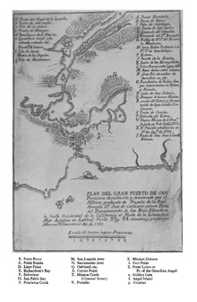
The first European known to visit the present-day location of Sausalito was Don José de Cañizares, on August 5, 1775. Cañizares was head of an advance party dispatched by longboat from the ship San Carlos, searching for a suitable anchorage for the larger vessel. The crew of the San Carlos came ashore soon after, reporting friendly natives and teeming populations of deer, elk, bear, sea lions, seals and otters. More significantly for maritime purposes, they reported an abundance of large, mature timber in the hills, a valuable commodity for shipwrights in need of raw materials for masts, braces and planking.
Despite these and later positive reports, the Spanish colonial government of Upper California did little to establish a presence in the area. When a military garrison (now the Presidio of San Francisco) and a Franciscan mission (Mission Dolores) were founded the following year, they were situated on the opposite, southern shore of the bay, where no portage was necessary for overland traffic to and from Monterey, the regional capitol. As a result, the far shore of the Golden Gate strait would remain largely wilderness for another half-century.

The development of the area began at the instigation of William A. Richardson, who arrived in Upper California in 1822, shortly after Mexico had won its independence from Spain. An English mariner who had picked up a fluency in Spanish during his travels, he quickly became an influential presence in the now-Mexican territory. By 1825, Richardson had assumed Mexican citizenship, converted to Catholicism and married the daughter of Don Ignacio Martínez, commandant of the Presidio and holder of a large land grant. His ambitions now expanding to land holdings of his own, Richardson submitted a petition to Governor Echienda for a rancho in the headlands across the water from the Presidio, to be called "Rancho Saucelito".[9] Sausalito is believed to refer to a small cluster of willows, a moist-soil tree, indicating the presence of a freshwater spring.[15]
Even before filing his claim, Richardson had used the spring as a watering station on the shores of what is now called Richardson Bay (an arm of the larger San Francisco Bay), selling fresh water to visiting vessels. However, his ownership of the land was legally tenuous: other claims had been submitted for the same region, and at any rate Mexican law reserved headlands for military uses, not private ownership. Richardson temporarily abandoned his claim and settled instead outside the Presidio, building the first permanent civilian home and laying out the street plan for the pueblo of Yerba Buena (present-day San Francisco). After years of lobbying and legal wrangling, Richardson was given clear title to all 19،751 acre (79.93 km2) of Rancho del Sausalito on February 11, 1838.
قرية الصيد وقطاع الترفيه
عقدة مواصلات
.JPG&filetimestamp=20150203163313&)
تهريب الخمور
الانتقال للصناعة أثناء الحرب العالمية الثانية
بعد الحرب
الديموغرافيا
2010
2000

منظمات خدمية وأندية


الاقتصاد
الصناعة


السياحة

التعليم
الإعلام
المنتزهات والرفيه

مشاهير المواطنين

سوساليتو في الخيال
سوساليتو في الموسيقى
مدن شقيقة
انظر أيضاً
المصادر
- ^ "California Cities by Incorporation Date" (Word). California Association of Local Agency Formation Commissions. Retrieved August 25, 2014.
- ^ "مجلس المدينة". سوساليتو، كاليفورنيا. Retrieved December 30, 2014.
- ^ أ ب "Statewide Database". UC Regents. Retrieved December 30, 2014.
- ^ قالب:Cite GovTrack
- ^ "2010 Census Gazetteer File - Places - California". United States Census Bureau. Retrieved October 13, 2014.
- ^ أ ب ت "Sausalito". نظام معلومات الأسماء الجغرافية، المسح الجيولوجي الأمريكي. Retrieved accessdate-January 8, 2015.
{{cite web}}: Check date values in:|accessdate=(help) - ^ أ ب قالب:California's Geographic Names
- ^ *"Review: Roaring Camp: The Social World of the California Gold Rush", American Scholar, 1 January 2000, p. 142 Vol. 69 No. 1 ISSN 0003-0937
- ^ أ ب Robert Ryal Miller, Captain Richardson, Mariner, Ranchero, and Founder of San Francisco Berkeley: La Loma Press, 1995 [Call number at SSU: Regional Room F869 .S353 R546] 1995
- ^ Greg Lucas, Chronicle Sacramento Bureau (2006-06-15). ""Now, houseboats not really sunk: Assembly bill seeks to legalize mooring on public property", San Francisco Chronicle, June 15, 2006". Sfgate.com. Retrieved 2012-06-25.
- ^ Greg Lucas, Chronicle Sacramento Bureau (2006-06-15). "op. cit., San Francisco Chronicle, June 15, 2006". Sfgate.com. Retrieved 2012-06-25.
- ^ Average weather for Sausalito Weather Channel Retrieved 2012-12-22
- ^ Peterson, Bonnie J. (1976). Dawn of the World: Coast Miwok Myths. ISBN 0-912908-04-1
- ^ National Park Service. (2005). Cultural Landscape Report for Fort Baker, Golden Gate National Recreation Area.
- ^ Tracy, Jack. Sausalito Moments in Time: A Pictorial History of Sausalito 1850-1950. Sausalito:Windgate Press 1983. ISBN 0-915269-00-7
قراءات إضافية
- Tracy, Jack. Sausalito Moments in Time: A Pictorial History of Sausalito 1850–1950. Sausalito:Windgate Press 1983. ISBN 0-915269-00-7.
- Sausalito Historical Society. Sausalito (Images of America). San Francisco: Arcadia Publishing, 2005. ISBN 0-7385-3036-0.
وصلات خارجية
- Official website
- Sausalito Chamber of Commerce
- Sausalito local newspaper
- Sausalito reference site
- Radio Sausalito (Emergency Broadcasting System for local government)
- Sausalito-on-the-Waterfront Foundation
- Sausalito Artists Art Community & Events
- Sausalito Art Festival Foundation
- Spaulding Wooden Boat Center
- Arques School of Traditional Boatbuilding
- Sausalito Lion's Club
- Rotary Club of Sausalito
- Sausalito Yacht Club


.JPG&filetimestamp=20150203163313)
- Short description is different from Wikidata
- Articles with hatnote templates targeting a nonexistent page
- Missing redirects
- Pages using gadget WikiMiniAtlas
- Articles with specifically marked weasel-worded phrases from April 2018
- Articles with unsourced statements from December 2012
- Articles with unsourced statements from September 2021
- Official website different in Wikidata and Wikipedia
- سوساليتو، كاليفورنيا
- مدن في مقاطعة مارين، كاليفورنيا
- مدن في منطقة خليج سان فرانسيسكو
- مدن وبلدات مدمجة في كاليفورنيا
- معالم سياحية في منطقة خليج سان فرانسيسكو