خط العرض 70° شمالاً

Line across the Earth
70°
خط العرض 70 شمال
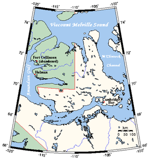
On Victoria Island, Canada, part of the border between Northwest Territories (green) and Nunavut (white) is defined by the 70th parallel north

خط العرض 70 شمالًا (إنگليزية: 70th parallel north) هي دائرة عرض بزاوية 70 درجة شمال خط الاستواء. تمر دائرة العرض 70° شمالاً عبر أفريقيا، المحيط الهندي، جنوب آسيا، جنوب شرق آسيا، المحيط الهادي، أمريكا الوسطى، امريكا الجنوبية والمحيط الأطلسي.

عند خط العرض هذا، تكون الشمس مرئية لمدة 24 ساعة ، 0 دقيقة أثناء الانقلاب الصيفي، والشفق المدني أثناء الانقلاب الشتوي


. . . . . . . . . . . . . . . . . . . . . . . . . . . . . . . . . . . . . . . . . . . . . . . . . . . . . . . . . . . . . . . . . . . . . . . . . . . . . . . . . . . . . . . . . . . . . . . . . . . . . . . . . . . . . . . . . . . . . . . . . . . . . . . . . . . . . . . . . . . . . . . . . . . . . . . . . . . . . . . . . . . . . . . .

حول العالم

بدءاً من خط الزوال الرئيسي، في الاتجاه الشرقي، يمر خط العرض 70° شمالاً عبر:

الإحداثيات البلد أو الإقليم أو البحر ملاحظات
70°0′N 0°0′E / 70.000°N 0.000°E / 70.000; 0.000 (Prime Meridian) Atlantic Ocean Norwegian Sea
70°0′N 18°40′E / 70.000°N 18.667°E / 70.000; 18.667 (Norway) Flag of Norway.svg نرويج Troms – islands of Rebbenesøya, Ringvassøy, Reinøya, Karlsøya and Kågen; mainland; island of Skorpa; mainland
Finnmark (mainland)
70°0′N 27°22′E / 70.000°N 27.367°E / 70.000; 27.367 (Finland) Flag of Finland.svg فنلندا Passing about 10 km south of the northernmost point of Finland, which is located at 70°05.537′N 27°57.335′E / 70.092283°N 27.955583°E / 70.092283; 27.955583 in the village of Nuorgam
70°0′N 28°2′E / 70.000°N 28.033°E / 70.000; 28.033 (Norway) Flag of Norway.svg نرويج Finnmark
70°0′N 29°30′E / 70.000°N 29.500°E / 70.000; 29.500 (Barents Sea) Barents Sea
70°0′N 58°44′E / 70.000°N 58.733°E / 70.000; 58.733 (Russia) Flag of Russia.svg روسيا Vaygach Island
70°0′N 60°12′E / 70.000°N 60.200°E / 70.000; 60.200 (Barents Sea) Kara Sea
70°0′N 66°56′E / 70.000°N 66.933°E / 70.000; 66.933 (Russia) Flag of Russia.svg روسيا Yamal Peninsula
70°0′N 72°30′E / 70.000°N 72.500°E / 70.000; 72.500 (Gulf of Ob) Gulf of Ob
70°0′N 73°45′E / 70.000°N 73.750°E / 70.000; 73.750 (Russia) Flag of Russia.svg روسيا
70°0′N 159°53′E / 70.000°N 159.883°E / 70.000; 159.883 (East Siberian Sea) East Siberian Sea
70°0′N 168°13′E / 70.000°N 168.217°E / 70.000; 168.217 (Russia) Flag of Russia.svg روسيا Ayon Island
70°0′N 168°31′E / 70.000°N 168.517°E / 70.000; 168.517 (East Siberian Sea) East Siberian Sea
70°0′N 170°35′E / 70.000°N 170.583°E / 70.000; 170.583 (Russia) Flag of Russia.svg روسيا
70°0′N 171°48′E / 70.000°N 171.800°E / 70.000; 171.800 (East Siberian Sea) East Siberian Sea
70°0′N 177°56′E / 70.000°N 177.933°E / 70.000; 177.933 (Chukchi Sea) Chukchi Sea
70°0′N 162°27′W / 70.000°N 162.450°W / 70.000; -162.450 (United States)  الولايات المتحدة Alaska
70°0′N 142°34′W / 70.000°N 142.567°W / 70.000; -142.567 (Beaufort Sea) Beaufort Sea
70°0′N 131°2′W / 70.000°N 131.033°W / 70.000; -131.033 (Canada) Flag of Canada.svg كندا Northwest TerritoriesTuktoyaktuk Peninsula
70°0′N 129°30′W / 70.000°N 129.500°W / 70.000; -129.500 (Beaufort Sea) Beaufort Sea
70°0′N 128°18′W / 70.000°N 128.300°W / 70.000; -128.300 (Canada) Flag of Canada.svg كندا Northwest TerritoriesCape Bathurst Peninsula
70°0′N 126°54′W / 70.000°N 126.900°W / 70.000; -126.900 (Amundsen Gulf) Amundsen Gulf
70°0′N 125°12′W / 70.000°N 125.200°W / 70.000; -125.200 (Canada) Flag of Canada.svg كندا Northwest TerritoriesParry Peninsula
70°0′N 124°30′W / 70.000°N 124.500°W / 70.000; -124.500 (Amundsen Gulf) Amundsen Gulf
70°0′N 117°22′W / 70.000°N 117.367°W / 70.000; -117.367 (Canada) Flag of Canada.svg كندا On Victoria Island:
Northwest Territories
Northwest Territories / Nunavut border
Northwest Territories
Northwest Territories / Nunavut border
Nunavut
70°0′N 100°48′W / 70.000°N 100.800°W / 70.000; -100.800 (Victoria Strait) Victoria Strait
70°0′N 98°50′W / 70.000°N 98.833°W / 70.000; -98.833 (Larsen Sound) Larsen Sound Passing just north of King William Island, Nunavut, Flag of Canada.svg كندا
70°0′N 97°35′W / 70.000°N 97.583°W / 70.000; -97.583 (James Ross Strait) James Ross Strait Passing just north of the Clarence Islands, Nunavut, Flag of Canada.svg كندا
70°0′N 96°17′W / 70.000°N 96.283°W / 70.000; -96.283 (Canada) Flag of Canada.svg كندا Boothia Peninsula, Nunavut
70°0′N 92°1′W / 70.000°N 92.017°W / 70.000; -92.017 (Gulf of Boothia) Gulf of Boothia
70°0′N 86°54′W / 70.000°N 86.900°W / 70.000; -86.900 (Canada) Flag of Canada.svg كندا NunavutCrown Prince Frederik Island
70°0′N 86°27′W / 70.000°N 86.450°W / 70.000; -86.450 (Fury and Hecla Strait) Fury and Hecla Strait
70°0′N 84°20′W / 70.000°N 84.333°W / 70.000; -84.333 (Canada) Flag of Canada.svg كندا NunavutBaffin Island
70°0′N 81°9′W / 70.000°N 81.150°W / 70.000; -81.150 (Murray Maxwell Bay) Murray Maxwell Bay
70°0′N 80°19′W / 70.000°N 80.317°W / 70.000; -80.317 (Canada) Flag of Canada.svg كندا NunavutBaffin Island
70°0′N 78°39′W / 70.000°N 78.650°W / 70.000; -78.650 (Steensby Inlet) Steensby Inlet
70°0′N 77°41′W / 70.000°N 77.683°W / 70.000; -77.683 (Canada) Flag of Canada.svg كندا NunavutBaffin Island
70°0′N 67°20′W / 70.000°N 67.333°W / 70.000; -67.333 (Baffin Bay) Baffin Bay Northern limit of the Davis Strait
70°0′N 53°39′W / 70.000°N 53.650°W / 70.000; -53.650 (Greenland) Flag of Greenland.svg گرينلاند Disko Island
70°0′N 52°30′W / 70.000°N 52.500°W / 70.000; -52.500 (Sullorsuaq Strait) Sullorsuaq Strait
70°0′N 51°28′W / 70.000°N 51.467°W / 70.000; -51.467 (Greenland) Flag of Greenland.svg گرينلاند Nuussuaq Peninsula
70°0′N 50°37′W / 70.000°N 50.617°W / 70.000; -50.617 (Torsukattak Fjord) Torsukattak Fjord
70°0′N 50°10′W / 70.000°N 50.167°W / 70.000; -50.167 (Greenland) Flag of Greenland.svg گرينلاند Sermeq Kujalleq
70°0′N 27°20′W / 70.000°N 27.333°W / 70.000; -27.333 (Gaasefjord) Gaasefjord
70°0′N 25°15′W / 70.000°N 25.250°W / 70.000; -25.250 (Greenland) Flag of Greenland.svg گرينلاند Geikie Plateau
70°0′N 22°18′W / 70.000°N 22.300°W / 70.000; -22.300 (Arctic Ocean) Arctic Ocean Greenland Sea
Norwegian Sea


انظر ايضا