جزر پاراسل
| جزيرة متنازع عليهاs أسماء أخرى: جزر شيشا أرخبيل هوانگ سا جزر وست ساند[1] | |
|---|---|
 جزر پاراسل حيث احتياطيات النفط والغاز الطبيعي في المياه المحيطة. | |
| الجغرافيا | |
| الموقع | بحر الصين الجنوبي |
| الإحداثيات | 16°30′N 112°00′E / 16.500°N 112.000°E |
| إجمالي الجزر | أكثر من 30 |
| الجزر الرئيسية | جزيرة روكي، جزيرة تري، جزيرة وودي، Money, روبرت، Pattle، تريتون، دنكان, لنكون |
| المساحة | 15,000 كم² ocean surface (7.75 كم² land surface) |
| طول الساحل | 518 كم |
| أعلى نقطة |
|
| يديرها | |
| الصين | |
| مدينة بمستوى محافظة مقاطعة | سانشا[2] هاينان |
| يطالب بها | |
| الصين | |
| المقاطعة | Paracels, Spratlys, and Zhongsha Islands Authority, هاينان |
| تايوان | |
| البلدية | كاوشونگ |
| ڤيتنام | |
| المركز | هوانگ سا، دا نانگ |
| الديمغرافيا | |
| التعداد | أكثر من 1000 (as of 2014) |
| الجماعات العرقية | صينيون |
| جزر پاراسل | |||||||||||
|---|---|---|---|---|---|---|---|---|---|---|---|
 | |||||||||||
| Chinese name | |||||||||||
| الصينية التقليدية | 西沙羣島 or 西沙群島 | ||||||||||
| الحروف المبسطة | 西沙群岛 | ||||||||||
| |||||||||||
| Vietnamese name | |||||||||||
| Vietnamese alphabet | Quần đảo Hoàng Sa | ||||||||||
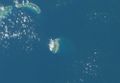
جزر پاراسل Paracel Islands، وتسمى أيضا جزر شيشا (西沙群岛) بالصينية، جزر هوأنگ سا بالڤتنامية جزر هوانگ سا، هي مجموعة جزر تحت ادارة مقاطعة هاينان، الصين. تطالب ڤيتنام وتايوان بالسيادة على تلك الجزر. في عام 1974 أدارت كل من تايوان وڤيتنام الجنوبية جزء من جزيرة پاراسل. أدى نزاع سريع حدث في عام 1974 إلى مقتل 18 جندي، ومنذ ذلك الحين استطاعت الصين من فرض سيطرتها على الجزيرة، ومازالت هذه السيطرة محل نزاع مع ڤيتنام.
تتكون جزر پاراسل من أكثر من 30 جزيرة صغيرة، رصيف رملي أو شعاب، تشغل حوالي 15,000 كم² من سطح المحيط، وتقع في بحر الصين الجنوبي.
الجغرافيا
بيانات جغرافية
- Geographic coordinates: 16°30′N 112°00′E / 16.500°N 112.000°E
- الساحل: 518 كم
- المناخ: استوائي
- أقصى ارتفاع
- أوطى نقطة: شرق البحر 0 م
- أعلى نقطة: مكان لا يحمل اسم في جزيرة روكي 14 م
- الموارد الطبيعية: صيد الأسماك، الشعاب المرجانية، نفط وغاز طبيعي.
- أخطار طبيعية: تايفونات
مجموعة أمفيتريت
مجموعة كرسنت

Duncan Islands
Drummond Island
Money Island
Antelope Reef
Robert Island
Pattle Island
Observation Bank
|
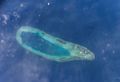
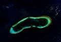
Lying about 70 km (43 mi) southwest of Amphitrite group, at the latitude of 16.52 degrees North and the longitude of 111.63 degrees East, this group consists of 8 islands and forms a crescent-like structure hanging from west to east and enclosing a deep central lagoon. The group measures 31 km (19 mi) and 15 km (9 mi) in length and width, from east to west and from north to south, respectively. All of the islands of the group are vegetated except for small cays. Located in the southwestern extremity of the group, at the hanging point of the crescent structure, is Money Island. This feature has some small cays in the southern side. The Antelope Reef, submerged at high tide and containing a central lagoon, lies 2.4 km (1.5 mi) east of the island of Money. Respectively, northeast of this reef are Robert and Pattle Islands. They are separated from each other by a 3.5 km (2.2 mi) wide, deep channel. The latter is the largest island of the group; a lighthouse and a radio and weather station were built there on 1937. The Observation Bank situates at the northernmost of the Crescent group and contains a small cay; from the southeastern side lying a 12 km (7 mi) long, boomerang shaped reef with the island of Drummond. The last distinct unit of the atoll-like structure is the Duncan Islands group, which is approximately 3 km (2 mi) west of the Drummond Island and about 8 km (5 mi) east of the island of Antelope.
- Pattle Islands
- Money Island
- Drummond Island
- Duncan Islands
مميزات أخرى

قائمة الأسماء الصينية والڤيتنامية لجزر پاراسل
| الاسم | الاسم الصيني | الاسم الڤيتنامي | الاحداثيات | المساحة (كم2) | الموقع/هوامش |
|---|---|---|---|---|---|
| مجموعة أمفيتريت | Xuande Islands (宣德群岛) | Nhóm An Vĩnh, Tuyên Đức | 16°50′N 112°20′E / 16.833°N 112.333°E | - | NE of the Islands |
| جزيرة ودي | Yongxing Dao (永兴岛) | Đảo Phú Lâm | 16°50′N 112°19′E / 16.833°N 112.317°E | 2.1 | Has airport, Center East |
| جزيرة روكي | Shidao (石岛) | Đảo Hòn Đá | 16°50′N 112°19′E / 16.833°N 112.317°E | 0.08 | connected to (NE of) Woody, 14m elev. |
| West Sand | Xisha Zhou (西沙洲) | Cồn Cát Tây | 16°50′N 112°19′E / 16.833°N 112.317°E | 0.04 | NW of Amphitrite Group |
| جزيرة تري | Zhaoshudao (赵述岛) | Đảo Cây | 16°50′N 112°19′E / 16.833°N 112.317°E | 0.22 | North of Amphitrite Group |
| (الأخوات السبع) | Qilian Yu Subgroup(七连屿) | - | - | - | NE of Amphitrite Group |
| جزيرة نورث | Bei Dao (北岛) | Đảo Bắc | 16°50′N 112°19′E / 16.833°N 112.317°E | 0.04 | N of Seven Islets(1) |
| Middle Island | Zhong Dao (中岛) | Đảo Trung/Giữa | 16°50′N 112°19′E / 16.833°N 112.317°E | 0.13 | N2 of Seven Islets(2) |
| South Island | Nan Dao (南岛) | Đảo Nam | 16°50′N 112°19′E / 16.833°N 112.317°E | 0.17 | N3 of Seven Islets(4) |
| (North Sand) | Bei Sha Zhou (北沙洲) | Cồn Cát Bắc | 16°50′N 112°19′E / 16.833°N 112.317°E | 0.02 | N4 of Seven Islets(4) |
| Middle Sand | Zhong Sha Zhou (中沙洲) | Đá Trung | 16°50′N 112°19′E / 16.833°N 112.317°E | 0.05 | N5 of Seven Islets(5) |
| South Sand | Nan Sha Zhou (南沙洲) | Cồn Cát Nam | 16°50′N 112°19′E / 16.833°N 112.317°E | 0.06 | N6 of Seven Islets(6) |
| (New West Sand) | Xixinsha Zhou (西新沙洲) | Chuỗi Tiên Sa | 16°50′N 112°19′E / 16.833°N 112.317°E | 0.002 | N7a of Seven Islets(7W) |
| (south of South Sand) | Dong Xin Sha Zhou (东新沙洲) | Chuỗi Cát Bằng | 16°50′N 112°19′E / 16.833°N 112.317°E | 0.004 | N7b of Seven Islets(7E) |
| Itis Bank | Yin Shuo Tan (银铄滩) | Bãi Liên Đông | 16°50′N 112°19′E / 16.833°N 112.317°E | - | SW of Amphitrite Group |
| Crescent Group | Yongle Islands(永樂群島) | Nhóm Trăng Khuyết | 16°30′N 111°40′E / 16.500°N 111.667°E | - | - |
| Money Island | Jinyin Dao (金银岛) | Đảo Quang Ảnh | 16°30′N 111°40′E / 16.500°N 111.667°E | 0.36 | West end of Crescent Group |
| Robert Island | Ganquan Dao (甘泉岛) | Đảo Hữu Nhật | 16°30′N 111°40′E / 16.500°N 111.667°E | 0.30 | W side of Crescent Group |
| Pattle Island | Shanhu Dao (珊瑚岛) | Đảo Hoàng Sa | 16°30′N 111°40′E / 16.500°N 111.667°E | 0.31 | N of Robert Island |
| Antelope Reef | Lingyang Jiao (羚羊礁) | Bãi ngầm Sơn Dương | 16°30′N 111°40′E / 16.500°N 111.667°E | - | W side of Crescent Group, S of Robert Is. |
| (Little Basket Sandbank) | Kuangzai Shazhou (筐仔沙洲) | Bãi Đá Nổi | 16°30′N 111°40′E / 16.500°N 111.667°E | 0.01 | S of Crescent Group |
| Duncan Island | Shenhang Dao (琛航岛) | Đảo Quang Hòa Đông Đảo Quang Hòa Tây |
16°30′N 111°40′E / 16.500°N 111.667°E | 0.28 | S side of Crescent Group |
| (Guangjin Island) | Guangjin Dao (广金岛) | Đảo Hoàng Châu | 16°30′N 111°40′E / 16.500°N 111.667°E | 0.06 | S side of Crescent Group |
| Drummond Island | Jinqing Dao (晋卿岛) | Đảo Duy Mộng | 16°30′N 111°40′E / 16.500°N 111.667°E | 0.21 | SE of Crescent Group |
| (Stone Islet) | Shi Yu (石屿) | Hòn Đá Nổi | 16°30′N 111°40′E / 16.500°N 111.667°E | 0.002 | NE of Crescent Group |
| (Minor Silver Islet) | Yinyu Zai (银屿仔) | Hòn Vọng Tuyết | 16°30′N 111°40′E / 16.500°N 111.667°E | 0.002 | SE of Yin Yu |
| (Silver Islet) | Yin Yu (银屿) | Hòn Đá Bạc | 16°30′N 111°40′E / 16.500°N 111.667°E | 0.01 | NE of Crescent Group |
| (He Duck Island) | Yagong Dao (鸭公岛) | Đảo Khe Sang | 16°30′N 111°40′E / 16.500°N 111.667°E | 0.01 | SW of Yin Yu |
| (All Wealth Island) | Quanfu Dao (全富岛) | Đảo Phú Hảo | 16°30′N 111°40′E / 16.500°N 111.667°E | 0.02 | NE of Pattle,SW of Yin Yu |
| (Salty Hut Islet) | Xianshe Yu (咸舍屿) | Hòn Đá Mặn | 16°30′N 111°40′E / 16.500°N 111.667°E | - | W of Shiyu |
| Other features | - | - | - | - | - |
| Triton Island | Zhongjiandao (中建岛) | Đảo Tri Tôn | 15°40′N 111°10′E / 15.667°N 111.167°E | 1.20 | SW of the Islands |
| Discovery Reef | Huaguang Jiao (华光礁) | Đá Lồi | 16°10′N 111°40′E / 16.167°N 111.667°E | - | S of Xuande Islands (宣德群岛) |
| Passu Keah | Panshi Yu (盘石屿) | Đảo Bạch Quỷ | 16°05′N 111°35′E / 16.083°N 111.583°E | 0.40 | S of Discovery Reef |
| (Songtao Beach) | Songtao Tan (嵩焘滩) | Đảo Ngân Quý | 15°35′N 112°15′E / 15.583°N 112.250°E | - | Central South of the Islands |
| Bombay Reef | Langhuajiao (浪花礁) | Đá Bông Bay | 16°02′N 112°32′E / 16.033°N 112.533°E | - | SE of the Islands |
| Vuladdore Reef | Yuduo Jiao (玉琢礁) | Đảo Chim Yến | 16°20′N 112°00′E / 16.333°N 112.000°E | - | SE of Xuande Islands, Center of the Islands |
| Bremen Bank | Binmei Tan (滨湄滩) | Bãi ngầm Bremen | 16°22′N 112°40′E / 16.367°N 112.667°E | - | Eastern Group |
| Jehangire Bank | Zhanhan Tan (湛涵滩) | Bãi ngầm Jehangire | 16°20′N 112°30′E / 16.333°N 112.500°E | - | Eastern Group |
| Neptune Bank | Beibian Lang (北边廊) | Bãi Thổ Tinh | 16°31′N 112°31′E / 16.517°N 112.517°E | - | Eastern Group |
| Pyramid Rock | Gaojian Shi (高尖石) | Hòn Tháp | 16°35′N 112°08′E / 16.583°N 112.133°E | 0.04 | Eastern Group |
| Lincoln Island | Dong Dao (东岛) | Đảo Linh Côn | 16°40′N 112°18′E / 16.667°N 112.300°E | 1.60 | Eastern Group |
| Dido Bank | Xidu Tan (西渡滩) | Rặng Thuỷ Tứ | 16°48′N 112°52′E / 16.800°N 112.867°E | - | SE of the Islands |
| North Reef | Beijiao (北礁) | Cồn Bắc | 17°05′N 111°30′E / 17.083°N 111.500°E | - | NW of the Islands |
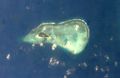
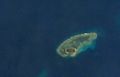
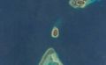
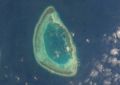
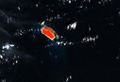
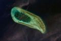
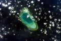
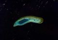
صور بالقمر الصناعي

Crescent Group
Money Island
Pattle Island
Robert Island
Antelope Reef
Woody Island
Bombay Reef

Bremen Bank
Discovery Reef
Iltis Bank
Lincoln Island
North Reef
Passu Keah Reef

Triton Island
Vuladdore Reef


معلومات عن الجزر
خلفية تاريخية للنزاع على الجزر
منظور تاريخي


پاراسل في الإعلام
انظر أيضا
المصادر
- ^ Jones, Gareth Wyn (2002). "Provinces". In Boland-Crewe, Tara and Lea, David (ed.). The Territories of the People's Republic of China. London: Europa Publications. p. 101. ISBN 978-0-203-40311-2.
{{cite book}}: CS1 maint: multiple names: editors list (link) - ^ 民政部关于国务院批准设立地级三沙市的公告 [Ministry of Public Affairs Announcement: State Council Ratification on the Establishment of Shashi City] (in الصينية). 中华人民共和国民政部 (Ministry of Foreign Affairs of the People's Republic of China). 21 June 2012. Retrieved 24 July 2014.
هوامش
المراجع
- (1686) Do Ba Cong Dao (translated by Buu Cam), "Toan Tap Thien Nam Tu Chí Lo Do Thu ", Hong Duc Ban Do, Saigon, 1962.
- (1776) Le Quí Don (translated by Le Xuan Giao), "Phu Bien Tap Luc", Saigon, 1972.
- (1821) Phan Huy Chu (translated by Nguyen Tho Duc), "Lich Trieu Hien Chuong Loai Chí", Saigon, 1972.
- Jean Louis TABERD, "Note on the Geography of Cochinchina", Journal of the Royal Asiatic Society of Bengal, Calcutta, Vol. VI, 9/1837.
- (1838) Jean Louis TABERD, "Additional Notice on the Geography of Cochinchina", Journal of the Royal Asiatic Society of Bengal, Calcutta, Vol. VII, 4/1838, pp 317 – 324.
- (1849) GUTZLAFF, "Geography of the Cochinchinese Empire", Journal of The Geographical Society of London, vol the 19th, p93.
- Vietnamese Claims to the Truong Sa Archipelago.Todd C. Kelly, August 1999.
وصلات خارجية
- Sovereignty over the Paracel and Spratly Islands, by Monique Chemillier-Gendreau
- Website about Paracels and Spratly
- CIA World Factbook for Paracel Islands
- Territorial claims in the Spratly and Paracel Islands
- A Collection of Documents on Paracel and Spratly Islands by HoangSa.Org
- Paracels Islands Dispute
- A Collection of Documents on Paracel and Spratly Islands by Nguyen Thai Hoc Foundation
| مناطق النزاع في شرق، جنوب، وجنوب شرق آسيا | |||
|---|---|---|---|
| النوع | المنطقة | الادارة الحالية | المطالبات |
| أراضي: | أكساي تشين | ||
| جبل بائكدو | |||
| Heixiazi / بولشوي اوسورييسكي (الجزء الشرقي)2 | |||
| Indo-Bangladesh enclaves3 | |||
| محافظة كاتشين | |||
| كشمير3 | |||
| محافظة كايين | |||
| شبه الجزيرة الكورية والجزر القريبة منها3 | |||
| بر الصين الرئيسي | |||
| شمال بورنيو (صباح)2 | |||
| منغوليا الخارجية2 | |||
| جبال پامير3 | |||
| فطاني | |||
| دولة شان | |||
| القرى الستة وأربعين شرق النهر2 | |||
| جنوب التبت (الآن أرونچال پرادش في الهند) | |||
| Tannu Uriankhai (now Tuva Republic of Russia)2 | |||
| Trans-Karakoram Tract | |||
| دولة وا | |||
| جزر ومياه: | جزر دياو يو تاي/ جزر سنكاكو | ||
| Kinmen | |||
| Kori Creek2 | |||
| Liancourt Rocks | |||
| Macclesfield Bank | |||
| Matsu | |||
| Paracel Islands | |||
| Pedra Branca, Middle Rocks, and South Ledge | |||
| جزر پراتاس | |||
| Scarborough Shoal | |||
| Socotra Rock | |||
| جزر كوريل الجنوبية | |||
| جزر سپراتلي3 | |||
| تايوان وPenghu2 | |||
| الهوامش: | 1حكومة في المنفى/جماعة منفية. 2Inactive dispute. 3Divided among multiple claimants. | ||
| مستوى محافظة |
|  | |||||||
|---|---|---|---|---|---|---|---|---|---|
| مستوى ناحية (بدون مستوى محافظة فوقها) |
| ||||||||
انظر أيضا: سياسة هاينان | |||||||||
| Đà Nẵng | Đà Nẵng • Cẩm Lệ • Hải Châu • Hòa Vang • جزر پاراسل (disputed) • Liên Chiểu • Ngũ Hành Sơn • Sơn Trà • Thanh Khê |  |
|---|---|---|
| Quảng Nam Province | Tam Kỳ • Hội An • Bắc Trà My • Duy Xuyên • Đại Lộc • Điện Bàn • Đông Giang • Hiệp Đức • Nam Giang • Nam Trà My • Nông Sơn • Núi Thành • Phú Ninh • Phước Sơn • Quế Sơn • Tây Giang • Thăng Bình • Tiên Phước | |
| Quảng Ngãi Province | ||
| Bình Định Province | ||
| Phú Yên Province | ||
| Khánh Hòa Province | Nha Trang • Cam Ranh • Khánh Sơn • Khánh Vĩnh • Cam Lâm • Diên Khánh • Ninh Hòa • Spratly Islands (disputed) • Vạn Ninh | |