إلجن، إلينوي
إلجن، إلينوي
Elgin, Illinois | |
|---|---|
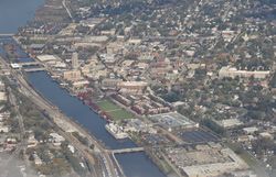
 منظر جوي لوسط إلجن | |
| الكنية: The City of Stars | |
| الشعار: جوهرة الغرب الأوسط The Jewel of the Midwest | |
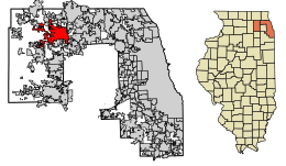
 موقع إلجن في مقاطعتي كين وكوك، إلينوي | |
| الإحداثيات: 42°02′18″N 88°19′22″W / 42.03833°N 88.32278°W[1] | |
| Country | |
| الولاية | |
| Counties | كوك وكين |
| Townships | Elgin, Dundee, Rutland, Plato, Hanover Township, Cook County, Illinois |
| Incorporated | 1854 |
| أسسها | 1835 |
| الحكومة | |
| • النوع | Home Rule, Council–manager |
| • العمدة | Dave Kaptain |
| • مدير المدينة | Rick Kozal |
| المساحة | |
| • الإجمالي | 38٫09 ميل² (98٫65 كم²) |
| • البر | 37٫52 ميل² (97٫16 كم²) |
| • الماء | 0٫57 ميل² (1٫49 كم²) 1.43% |
| المنسوب | 817 ft (249 m) |
| التعداد | |
| • الإجمالي | 108٬188 |
| • Estimate (2019)[4] | 110٬849 |
| • الكثافة | 2٬954٫79/sq mi (1٬140٫86/km2) |
| Standard of living (2011) | |
| • Median household income | $56,091 |
| • Median home value | $209,800 |
| منطقة التوقيت | UTC−6 (Central) |
| • الصيف (التوقيت الصيفي) | UTC−5 (Central) |
| ZIP code(s) | 60120–60125 |
| Area code(s) | 331, 847 and 224 |
| جيوكود | 17-23074 |
| FIPS code | 17-23074 |
| Demonym | Elginite |
| الموقع الإلكتروني | cityofelgin |
إلجن (Elgin ؛ /ˈɛldʒɪn/؛ EL-jin) هي مدينة في مقاطعتي كوك وكين في الجزء الشمالي من ولاية إلينوي. وتقع تقريباً على بعد 35 mi (56 km) شمال غرب شيكاغو، على نهر فوكس. وفي 2019، بلغ عدد سكان المدينة 110,849 نسمة،[5] مما يجعلها ثامن أكبر مدينة في إلينوي.
التاريخ
The Indian Removal Act of 1830 and the Black Hawk Indian War of 1832 led to the expulsion of the Native Americans who had settlements and burial mounds in the area, and set the stage for the founding of Elgin. Thousands of militiamen and soldiers of Gen. Winfield Scott's army marched through the Fox River valley during the war, and accounts of the area's fertile soils and flowing springs soon filtered east.
الجغرافيا
الطبوغرافيا
Elgin is located at 42°2′18″N 88°19′22″W / 42.03833°N 88.32278°W (42.0384225, −88.3226510).[1]
المناخ
| الشهر | Jan | Feb | Mar | Apr | May | Jun | Jul | Aug | Sep | Oct | Nov | Dec | Year |
|---|---|---|---|---|---|---|---|---|---|---|---|---|---|
| متوسط درجة الحرارة العليا °F | 29.6 |
34.0 |
45.5 |
58.7 |
69.7 |
79.8 |
83.6 |
81.9 |
75.1 |
62.0 |
47.5 |
33.2 |
58.4 |
| متوسط درجة الحرارة الدنيا °ف | 13.7 |
17.0 |
26.8 |
37.4 |
47.7 |
57.8 |
63.0 |
61.2 |
52.3 |
40.1 |
30.4 |
17.8 |
38.8 |
| هطل الأمطار في | 1.65 |
1.50 |
1.97 |
3.67 |
4.35 |
3.88 |
3.81 |
4.97 |
3.42 |
2.92 |
3.09 |
2.02 |
37.24 |
| تساقط الثلج في | 9.9 |
7.6 |
2.9 |
0.4 |
0.0 |
0.0 |
0.0 |
0.0 |
0.0 |
0.0 |
0.7 |
8.3 |
29.7 |
| Source: NOAA[6] | |||||||||||||
On March 28, 1920, Elgin was struck by several tornadoes along the Fox River that caused significant damage to Chicago and several western suburbs. Twenty-three people were killed and several businesses and homes were destroyed, including the Opera House and Grant Theater.[7]
الديمغرافيا
| Demographics (2010)[8] | |||
|---|---|---|---|
| White | Black | Asian | |
| 65.9% | 7.4% | 5.4% | |
| Islander | Native | Other | Hispanic (any race) |
| 0.0% | 1.4% | 16.3% | 43.6% |
| التعداد | Pop. | ملاحظة | %± |
|---|---|---|---|
| 1860 | 2٬797 | — | |
| 1870 | 5٬441 | 94٫5% | |
| 1880 | 8٬787 | 61٫5% | |
| 1890 | 17٬823 | 102٫8% | |
| 1900 | 22٬433 | 25٫9% | |
| 1910 | 25٬976 | 15٫8% | |
| 1920 | 27٬454 | 5٫7% | |
| 1930 | 35٬929 | 30٫9% | |
| 1940 | 38٬333 | 6٫7% | |
| 1950 | 44٬223 | 15٫4% | |
| 1960 | 49٬447 | 11٫8% | |
| 1970 | 55٬691 | 12٫6% | |
| 1980 | 63٬798 | 14٫6% | |
| 1990 | 77٬010 | 20٫7% | |
| 2000 | 94٬487 | 22٫7% | |
| 2010 | 108٬188 | 14٫5% | |
| 2019 (تق.) | 110٬849 | [4] | 2٫5% |
| U.S. Decennial Census[9] | |||
الهامش
- ^ أ ب ت "City of Elgin". نظام معلومات الأسماء الجغرافية، المسح الجيولوجي الأمريكي.
- ^ "2019 U.S. Gazetteer Files". United States Census Bureau. Retrieved July 14, 2020.
- ^ "Elgin (city), Illinois". State & County QuickFacts. U.S. Census Bureau. 8 July 2014. Archived from the original on 26 June 2012. Retrieved 16 September 2014.
- ^ أ ب "Population and Housing Unit Estimates". United States Census Bureau. May 24, 2020. Retrieved May 27, 2020.
- ^ "Population and Housing Unit Estimates". Retrieved May 21, 2020.
- ^ "NowData - NOAA Online Weather Data". National Oceanic and Atmospheric Administration. Retrieved December 27, 2012.
{{cite web}}: CS1 maint: url-status (link) - ^ "Effects of a Tornado along the Fox River in Elgin, 1920". www.encyclopedia.chicagohistory.org. Archived from the original on 2012-07-07. Retrieved 2017-10-16.
- ^ "Profile of General Population and Housing Characteristics: 2010 Demographic Profile Data (DP-1): Elgin city, Illinois". U.S. Census Bureau, American Factfinder. Archived from the original on February 12, 2020. Retrieved February 11, 2013.
- ^ United States Census Bureau. "Census of Population and Housing". Retrieved April 27, 2015.
وصلات خارجية
- City of Elgin official website
- Northern Fox River Valley Guide
- Elgin Area Historical Society
- Historic Elgin
- Pages using gadget WikiMiniAtlas
- CS1 maint: url-status
- Short description is different from Wikidata
- Coordinates on Wikidata
- Articles with hatnote templates targeting a nonexistent page
- Pages using US Census population needing update
- إلجن، إلينوي
- تأسيسات 1835 في إلينوي
- منطقة شيكاغو العمرانية
- مدن إلينوي
- مدن مقاطعة كوك، إلينوي
- مدن مقاطعة كين، إلينوي
- أماكن مأهولة تأسست في 1835


