سخلده
| شلت Scheldt | |
|---|---|
 الشلت عند أنتوِرپ | |
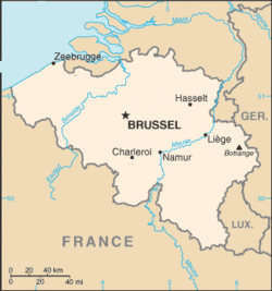 مسار السخلده | |
خطأ: إحداثيات غير صالحة. | |
| الاسم المحلي | فرنسية: l'Escaut (m), والون: Escô, هولندية: Schelde Error {{native name checker}}: list markup expected for multiple names (help) |
| السمات الطبيعية | |
| Source | |
| • location | فرنسا |
| • elevation | 97 متر |
| المصب | |
- الموقع | بحر الشمال |
• الإحداثيات | 51°25′51″N 3°31′44″E / 51.43083°N 3.52889°E |
| الطول | 360 كم |
| مساحة الحوض | 21،863 km2 (8،441 sq mi) |
| Discharge | |
| • average | 120 m3/s (4،200 cu ft/s) |
| سمات الحوض | |
| خطأ: الوظيفة "main" غير موجودة. | |
شلت (Scheldt؛ /ʃɛlt/؛ فرنسية: l'Escaut [ɛsko]؛ والون: Escô, هولندية: Schelde [ˈsxɛldə]) هو نهر يبلغ طوله 350 كيلومتر[1] في شمال فرنسا وغرب بلجيكا والجزء الجنوبي الغربي من هولندا. وإسمه مشتق من الصفة في الإنگليزية القديمة sceald "shallow", الإنگليزية الحديثة shoal، الألمانية السفلى schol، بالفريزية الغربية skol، و بالسويدية (البائدة) skäll "رفيع".
التاريخ
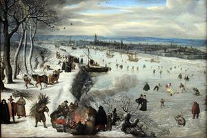
"منظر أنتوِرپ مع سخلده المجمد" (1590) بريشة Lucas van Valckenborch.
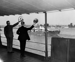
الرئيس الأمريكية هاري ترومان ووزير خارجيته جيمس بيرنز يلوِّحان للسفينة HMS Hambledon بينما هما على متن USS Augusta على نهر سخلده في طريقهما إلى مؤتمر پوتسدام في 15 يوليو 1945
الروافد

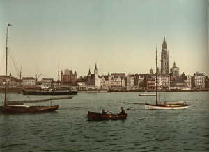
الشلت عند أنتوِرپ وقت الغروب.
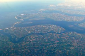
صورة ساتلية لدلتا سخلده قالب:Pufc
الملاحة
انظر أيضاً
الهامش
- ^ "VNSC Communicatie : vraagbaak voor alles op, rond en in de Schelde" (in الهولندية). Retrieved 2014-06-03.
المراجع
وصلات خارجية
- Water basin of the Scheldt
- www.scheldenet.nl
- ScheldeMonitor; Research studies and monitoring activities
- Deltaworks; Flood protection works in Scheldt Delta
- International Scheldt Commission
- Scaldit - Interreg IV B NWE project for a safer and cleaner Scheldt River Basin District (FR - BE (Walloon Region - Brussels Cap. Region - Flemish Region) - NL)
- Bibliography on Water Resources and International Law Peace Palace Library
- River Escaut with maps and details of places, ports and moorings, by the author of Inland Waterways of France, Imray
- Navigation details for 80 French rivers and canals (French waterways website section)
 Texts on Wikisource:
- "[[s:Collier's New Encyclopedia (1921)/{{{1}}}|{{{1}}}]]". Collier's New Encyclopedia. 1921.
- Chisholm, Hugh, ed. (1911). . دائرة المعارف البريطانية (eleventh ed.). Cambridge University Press.
{{cite encyclopedia}}: Cite has empty unknown parameter:|coauthors=(help) - James Wood (1907). "[[s:The Nuttall Encyclopædia/{{{first_letter}}}#{{{1}}}|{{{1}}}]]". The Nuttall Encyclopædia.
- Paget-Tyrell Memorandum of August 7, 1916, Section 6 (Belgium and the Scheldt)
This article contains content from Wikimedia licensed under CC BY-SA 4.0. Please comply with the license terms.
تصنيفات:
- Pages using gadget WikiMiniAtlas
- CS1 الهولندية-language sources (nl)
- Short description is different from Wikidata
- Articles containing فرنسية-language text
- Pages using Lang-xx templates
- Articles containing والون-language text
- Articles containing هولندية-language text
- Native name checker template errors
- Coordinates on Wikidata
- Pages using infobox river with unknown parameters
- مقالات المعرفة المحتوية على معلومات من دائرة المعارف البريطانية طبعة 1911
- حوض سخلده
- أنهار دلتا الراين-الموز-سخلده
- أنهار دولية في أوروپا
- أنهار فرتسا
- أنهار بلجيكا
- أنهار هولندا
- County of Flanders
- Rivers of Flanders
- Rivers of Wallonia
- Rivers of Aisne
- Rivers of Nord (French department)
- Rivers of Hauts-de-France
- Rivers of Antwerp (province)
- Rivers of East Flanders
- Rivers of Hainaut (province)
- Rivers of West Flanders
- أنهار زيلاند
