المقاطعات التشريفية لإنگلترة
| المقاطعات التشريفية لإنگلترة Ceremonial counties (England) | |
|---|---|
| تُعرف باسم: المقاطعات الجغرافية | |
 | |
| التصنيف | مناطق النائبيات |
| الموقع | إنگلترة |
| التأسيس | المناطق |
| العدد | 48 (as of 2009) |
| عدد السكان | 8,000–8,167,000[1] |
| المساحة | 3–8,611 km² |
| الكثافة السكانية | 62–4,806/km² |
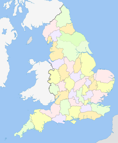
المقاطعات التشريفية لإنگلترة Ceremonial counties of England هي اسم جماعي للمناطق التي يُعيـَّن فيها نائب لورد. وقانونياً يُعرّفوا في قانون النائبيات 1997 بإسم المقاطعات والمناطق بغرض النائبيات في بريطانيا العظمى على النقيض من المناطق المستخدمة في الحكم المحلي
التاريخ

The distinction between a county for purposes of the Lieutenancy and a county for administrative purposes is not a new one: in some cases a county corporate that was part of a county was appointed its own Lieutenant (although the Lieutenant of the containing county would often be appointed to this position as well), and the three Ridings of يوركشر had been treated as three counties for Lieutenancy purposes since the 17th century.
التعريف
يُعرِّف قانون النائبيات 1997 المقاطعات لأغراض lieutenancies in terms of local government areas created by the Local Government Act 1972 as amended. وبالرغم من أن المصطلح غير مستخدم في القانون، فإن تلك المقاطعات تُعرف أحياناً بإسم "المقاطعات الاحتفالية". Schedule 1, paragraphs 2–5[2] كما عـُدِّل[3] (most recently in 2009[4]):
مناطق النائبيات منذ 1997
هذه هي 48 مقاطعة لأغراض النائبية في إنگلترة، كم ا هي معرّفة حالياً:
| مقاطعة لأغراض النائبية |
التعداد (2018)[5][6] |
Area | Density | Composition Metropolitan and non-metropolitan counties or unitary authority areas | |||||
|---|---|---|---|---|---|---|---|---|---|
| No. | Rank | (km2) | (sq mi) | Rank | (/km2) | (/sq mi) | Rank | ||
| Bedfordshire | 602,500 | 36th | 1،235 | 477 | align="right" | style="text-align:right;" data-sort-value="6996488000000000000"|488 | 1،260 | align="right" | Bedford, Central Bedfordshire and Luton |
| Berkshire | 836,300 | 26th | 1،262 | 487 | align="right" | style="text-align:right;" data-sort-value="6996663000000000000"|663 | 1،720 | align="right" | Bracknell Forest, Reading, Slough, West Berkshire, Windsor and Maidenhead and Wokingham |
| Bristol | 421,300 | 43rd | 110 | 42 | align="right" | style="text-align:right;" data-sort-value="6997384400000000000"|3،844 | 9،960 | align="right" | Bristol |
| Buckinghamshire | 725,400 | 30th | 1،874 | 724 | align="right" | style="text-align:right;" data-sort-value="6996387000000000000"|387 | 1،000 | align="right" | Buckinghamshire and Milton Keynes |
| Cambridgeshire | 769,100 | 28th | 3،390 | 1،310 | align="right" | style="text-align:right;" data-sort-value="6996227000000000000"|227 | 590 | align="right" | Cambridgeshire and Peterborough |
| Cheshire | 1,006,100 | 19th | 2،343 | 905 | align="right" | style="text-align:right;" data-sort-value="6996428999999999999"|429 | 1،110 | align="right" | Cheshire East, Cheshire West and Chester, Halton, and Warrington |
| City of London[note 1] | 7,900 | 48th | 2.90 | 1.12 | align="right" | style="text-align:right;" data-sort-value="6997272500000000000"|2،725 | 7،060 | align="right" | City of London |
| Cornwall | 534,300 | 39th | 3،563 | 1،376 | align="right" | style="text-align:right;" data-sort-value="6996150000000000000"|150 | 390 | align="right" | Cornwall and the Isles of Scilly |
| Cumbria | 496,600 | 41st | 6،767 | 2،613 | align="right" | style="text-align:right;" data-sort-value="6995730000000000000"|73 | 190 | align="right" | Cumbria |
| Derbyshire | 1,001,500 | 20th | 2،625 | 1،014 | align="right" | style="text-align:right;" data-sort-value="6996381999999999999"|382 | 990 | align="right" | Derbyshire and Derby |
| Devon | 1,141,600 | 11th | 6،707 | 2،590 | align="right" | style="text-align:right;" data-sort-value="6996170000000000000"|170 | 440 | align="right" | Devon, Plymouth and Torbay |
| Dorset | 710,500 | 32nd | 2،653 | 1،024 | align="right" | style="text-align:right;" data-sort-value="6996268000000000000"|268 | 690 | align="right" | Dorset and Bournemouth, Christchurch and Poole[7] |
| Durham | 892,600 | 23rd | 2،721 | 1،051 | align="right" | style="text-align:right;" data-sort-value="6996328000000000000"|328 | 850 | align="right" | County Durham, Darlington, Hartlepool and that part of Stockton-on-Tees north of the centre line of the River Tees |
| East Riding of Yorkshire | 593,700 | 37th | 2،479 | 957 | align="right" | style="text-align:right;" data-sort-value="6996238999999999999"|239 | 620 | align="right" | East Riding of Yorkshire and Kingston-upon-Hull |
| East Sussex | 766,400 | 29th | 1،791 | 692 | align="right" | style="text-align:right;" data-sort-value="6996428000000000000"|428 | 1،110 | align="right" | East Sussex and Brighton and Hove |
| Essex | 1,712,200 | 6th | 3،670 | 1،420 | align="right" | style="text-align:right;" data-sort-value="6996466999999999999"|467 | 1،210 | align="right" | Essex, Southend-on-Sea and Thurrock |
| Gloucestershire | 840,200 | 25th | 3،150 | 1،220 | align="right" | style="text-align:right;" data-sort-value="6996267000000000000"|267 | 690 | align="right" | Gloucestershire and South Gloucestershire |
| Greater London | 7,611,900 | 1st | 1،569 | 606 | align="right" | style="text-align:right;" data-sort-value="6997485099999999999"|4،851 | 12،560 | align="right" | The London boroughs |
| Greater Manchester | 2,573,500 | 3rd | 1،276 | 493 | align="right" | style="text-align:right;" data-sort-value="6997201699999999999"|2،017 | 5،220 | align="right" | Greater Manchester |
| Hampshire | 1,720,600 | 5th | 3،769 | 1،455 | align="right" | style="text-align:right;" data-sort-value="6996457000000000000"|457 | 1،180 | align="right" | Hampshire, Portsmouth and Southampton |
| Herefordshire | 179,300 | 45th | 2،180 | 840 | align="right" | style="text-align:right;" data-sort-value="6995820000000000000"|82 | 210 | align="right" | Herefordshire |
| Hertfordshire | 1,078,400 | 14th | 1،643 | 634 | align="right" | style="text-align:right;" data-sort-value="6996656000000000000"|656 | 1،700 | align="right" | Hertfordshire |
| Isle of Wight | 140,200 | 46th | 380 | 150 | align="right" | style="text-align:right;" data-sort-value="6996369000000000000"|369 | 960 | align="right" | Isle of Wight |
| Kent | 1,660,100 | 7th | 3،736 | 1،442 | align="right" | style="text-align:right;" data-sort-value="6996444000000000000"|444 | 1،150 | align="right" | Kent and Medway |
| Lancashire | 1,451,700 | 8th | 3،075 | 1،187 | align="right" | style="text-align:right;" data-sort-value="6996472000000000000"|472 | 1،220 | align="right" | Blackburn with Darwen, Blackpool and Lancashire |
| Leicestershire | 940,500 | 21st | 2،156 | 832 | align="right" | style="text-align:right;" data-sort-value="6996436000000000000"|436 | 1،130 | align="right" | Leicestershire and Leicester |
| Lincolnshire | 1,016,600 | 18th | 6،959 | 2،687 | align="right" | style="text-align:right;" data-sort-value="6996146000000000000"|146 | 380 | align="right" | Lincolnshire, North Lincolnshire and North East Lincolnshire |
| Merseyside | 1,347,800 | 9th | 645 | 249 | align="right" | style="text-align:right;" data-sort-value="6997209000000000000"|2،090 | 5،400 | align="right" | Merseyside |
| Norfolk | 850,800 | 24th | 5،371 | 2،074 | align="right" | style="text-align:right;" data-sort-value="6996158000000000000"|158 | 410 | align="right" | Norfolk |
| North Yorkshire | 1,073,200 | 15th | 8،608 | 3،324 | align="right" | style="text-align:right;" data-sort-value="6996125000000000000"|125 | 320 | align="right" | Middlesbrough, North Yorkshire, Redcar and Cleveland, York and part of Stockton-on-Tees south of the centre line of the River Tees |
| Northamptonshire | 685,000 | 33rd | 2،364 | 913 | align="right" | style="text-align:right;" data-sort-value="6996290000000000000"|290 | 750 | align="right" | Northamptonshire |
| Northumberland | 311,000 | 44th | 5،013 | 1،936 | align="right" | style="text-align:right;" data-sort-value="6995620000000000000"|62 | 160 | align="right" | Northumberland |
| Nottinghamshire | 1,068,900 | 17th | 2،159 | 834 | align="right" | style="text-align:right;" data-sort-value="6996495000000000000"|495 | 1،280 | align="right" | Nottinghamshire and Nottingham |
| Oxfordshire | 639,700 | 35th | 2،605 | 1،006 | align="right" | style="text-align:right;" data-sort-value="6996245999999999999"|246 | 640 | align="right" | Oxfordshire |
| Rutland | 39,200 | 47th | 382 | 147 | align="right" | style="text-align:right;" data-sort-value="6996103000000000000"|103 | 270 | align="right" | Rutland |
| Shropshire | 454,900 | 42nd | 3،488 | 1،347 | align="right" | style="text-align:right;" data-sort-value="6996129999999999999"|130 | 340 | align="right" | Shropshire and Telford and Wrekin |
| Somerset | 912,900 | 22nd | 4،170 | 1،610 | align="right" | style="text-align:right;" data-sort-value="6996218999999999999"|219 | 570 | align="right" | Bath and North East Somerset, North Somerset and Somerset |
| South Yorkshire | 1,305,900 | 10th | 1،552 | 599 | align="right" | style="text-align:right;" data-sort-value="6996842000000000000"|842 | 2،180 | align="right" | South Yorkshire |
| Staffordshire | 1,069,000 | 16th | 2،714 | 1،048 | align="right" | style="text-align:right;" data-sort-value="6996394000000000000"|394 | 1،020 | align="right" | Staffordshire and Stoke-on-Trent |
| Suffolk | 715,700 | 31st | 3،800 | 1،500 | align="right" | style="text-align:right;" data-sort-value="6996188000000000000"|188 | 490 | align="right" | Suffolk |
| Surrey | 1,109,700 | 12th | 1،663 | 642 | align="right" | style="text-align:right;" data-sort-value="6996667000000000000"|667 | 1،730 | align="right" | Surrey |
| Tyne and Wear | 1,093,400 | 13th | 540 | 210 | align="right" | style="text-align:right;" data-sort-value="6997202500000000000"|2،025 | 5،240 | align="right" | Tyne and Wear |
| Warwickshire | 530,500 | 40th | 1،975 | 763 | align="right" | style="text-align:right;" data-sort-value="6996268999999999999"|269 | 700 | align="right" | Warwickshire |
| West Midlands | 2,619,500 | 2nd | 902 | 348 | align="right" | style="text-align:right;" data-sort-value="6997290500000000000"|2،905 | 7،520 | align="right" | West Midlands |
| West Sussex | 781,600 | 27th | 1،991 | 769 | align="right" | style="text-align:right;" data-sort-value="6996392999999999999"|393 | 1،020 | align="right" | West Sussex |
| West Yorkshire | 2,200,500 | 4th | 2،029 | 783 | align="right" | style="text-align:right;" data-sort-value="6997108399999999999"|1،084 | 2،810 | align="right" | West Yorkshire |
| Wiltshire | 648,400 | 34th | 3،485 | 1،346 | align="right" | style="text-align:right;" data-sort-value="6996186000000000000"|186 | 480 | align="right" | Swindon and Wiltshire |
| Worcestershire | 557,600 | 38th | 1،741 | 672 | align="right" | style="text-align:right;" data-sort-value="6996320000000000000"|320 | 830 | align="right" | Worcestershire |
مناطق النائبيات Lieutenancy في 1890
- Bedfordshire
- Berkshire
- Buckinghamshire
- Cambridgeshire, including Isle of Ely
- Cheshire
- held jointly with Chester
- Cornwall
- Cumberland
- Derbyshire
- Devon
- محتفـَظ بها بالتشارك مع إكستر
- دورست
- held jointly with Poole
- Durham
- إسكس
- Gloucestershire
- Hampshire
- held jointly with Southampton
- Herefordshire
- Hertfordshire
- Huntingdonshire
- كنت
- held jointly with كانتربري
- Lancashire
- Leicestershire
- Lincolnshire
- held jointly with Lincoln
- City of London, having commissioners of Lieutenancy
- مقاطعة لندن
- مدلسكس
- نورفوك
- held jointly with Norwich
- Northamptonshire, including the Soke of Peterborough
- Northumberland
- held jointly with Berwick-upon-Tweed and Newcastle upon Tyne
- Nottinghamshire
- held jointly with Nottingham
- Oxfordshire
- Rutland
- Shropshire
- Somerset
- Staffordshire
- held jointly with Lichfield
- سفوك
- سسكس
- Warwickshire
- Westmorland
- Wiltshire
- Worcestershire
- held jointly with Worcester
- Yorkshire—had three Lieutenants, one for each of the three ridings
- East Riding, held jointly with Kingston upon Hull
- North Riding
- West Riding, held jointly with يورك
انظر أيضاً
- Historic counties of England
- Lieutenancy areas of Scotland
- List of articles about local government in the United Kingdom
- Nomenclature of Territorial Units for Statistics
- Preserved counties of Wales
References
- ^ [Table 2 2011 Census: Usual resident population and population density, local authorities in the United Kingdom UK Census 2011 UK usual resident population Greater London excluding City of London], Accessed 22 December 2012
- ^ قالب:UK-LEG
- ^ قالب:UK-LEG
- ^ قالب:UK-LEG
- ^ "Population Estimates for UK, England and Wales, Scotland and Northern Ireland, Mid-2019". Office for National Statistics. 6 May 2020. Retrieved 6 May 2020.
- ^ "Standard Area Measurements (2016) for Administrative Areas in the United Kingdom". Office for National Statistics. 1 February 2017. Retrieved 9 February 2017.
- ^ خطأ استشهاد: وسم
<ref>غير صحيح؛ لا نص تم توفيره للمراجع المسماةDorset
وصلات خارجية
خطأ استشهاد: وسوم <ref> موجودة لمجموعة اسمها "note"، ولكن لم يتم العثور على وسم <references group="note"/>