شرق سسكس
East Sussex | |||||||||||||||||||||||||||||||||||||||||||||||||||||||
|---|---|---|---|---|---|---|---|---|---|---|---|---|---|---|---|---|---|---|---|---|---|---|---|---|---|---|---|---|---|---|---|---|---|---|---|---|---|---|---|---|---|---|---|---|---|---|---|---|---|---|---|---|---|---|---|
 | |||||||||||||||||||||||||||||||||||||||||||||||||||||||
| البلد | المملكة المتحدة | ||||||||||||||||||||||||||||||||||||||||||||||||||||||
| المقاطعة | إنگلترة | ||||||||||||||||||||||||||||||||||||||||||||||||||||||
| المنطقة | South East England | ||||||||||||||||||||||||||||||||||||||||||||||||||||||
| التأسيس | 1974 (Local Government Act 1972) | ||||||||||||||||||||||||||||||||||||||||||||||||||||||
| منطقة التوقيت | UTC±00:00 (توقيت گرينتش المتوسط) | ||||||||||||||||||||||||||||||||||||||||||||||||||||||
| • الصيف (التوقيت الصيفي) | UTC+01:00 (توقيت بريطانيا الصيفي) | ||||||||||||||||||||||||||||||||||||||||||||||||||||||
| أعضاء البرلمان | |||||||||||||||||||||||||||||||||||||||||||||||||||||||
| |||||||||||||||||||||||||||||||||||||||||||||||||||||||
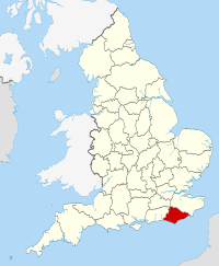
شرق سسكس (بالانجليزية: East Sussex) مقاطعة إنجليزية تقع في جنوب شرق إنجلترا يحدها شمال شرقا كنت وشمالا سري ومن الغرب والشمال الغربي مقاطعة غرب ساسكس و من الجنوب المقاطعة مطلة على البحر حيث يحدها يحدها القنال الإنجليزي.منذ القرن الثاني عشر عندما كانت مملكة ساسكس قائمة كان اقليم سسكس يدار بادارتين منفصلتين في شرقه وغربه. مركز المقاكعة هو بلدة لووز, توجد في المقاطعة ايضا مدينة برايتون الساحلية السياحية المهمه والمدينة ومنذ عام 1997 تتمتع بنوع من الادارة الذاتية تحت ما يسمى أقليم برايتون و هوف .أقتصاد المقاطعة يقوم على شركات الخدمات و التجارة و تشكل الصناعة المورد الاقتصادي الثاني و تليها السياحة, توجد في المقاطعة القليل من الانشطة الزراعية.
Economy and demography
أجزاء من هذا المقال (أولئك المتعلقين بـ القِسم) تحتاج أن تـُحدَّث. (September 2020) |
This is a chart of trend of regional gross value added of the non-metropolitan county of East Sussex (Brighton & Hove has a separate table) at current basic prices published (pp. 240–253) by Office for National Statistics with figures in millions of pounds.
| Year | Regional Gross Value Added[3] |
Agriculture[4] | Industry[5] | Services[6] |
|---|---|---|---|---|
| 1995 | 4,359 | 84 | 1,053 | 3,222 |
| 2000 | 4,953 | 54 | 1,155 | 3,744 |
| 2003 | 5,326 | 69 | 1,252 | 4,004 |
| Area | August 2012 | August 2001 | Population (April 2011) |
|---|---|---|---|
| East Sussex | 18,790 | 34,335 | 526,671 |
| % of 2011 resident population (2001 population where applicable) [مطلوب توضيح] |
3.6% | 7.0% | – |
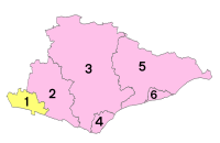
| Hastings | 6.7% | 12.1% | 90,254 |
| Eastbourne | 4.3% | 8.2% | 99,412 |
| Rother | 3.1% | 6.5% | 90,588 |
| Lewes | 3.0% | 5.7% | 97,502 |
| Wealden | 1.8% | 4.2% | 148,915 |
Politics
| General election 2019: East Sussex | ||||||||||
|---|---|---|---|---|---|---|---|---|---|---|
| Conservative | Labour | Liberal Democrats | Brexit | Green | Others | Turnout | ||||
| 197,728 +19,191 |
121,935 +26,216 |
75,754 +21,686 |
4,738 +4,738 |
42,143 +18,895 |
1898 +822 |
444196 +25,391 | ||||
| Overall number of seats as of 2019 | |||||||||
|---|---|---|---|---|---|---|---|---|---|
| Conservative | Labour | Green | Liberal Democrats | Brexit | Others | ||||
| 5 | 2 | 1 | 0 | 0 | 0 | ||||
Landmarks

See also
- Outline of England
- Historic coats of arms of East Sussex County Council
- History of local government in Sussex
- ESCIS
- List of High Sheriffs of East Sussex
- List of hills of East Sussex
- The Keep: the county's archive and record office, near Falmer
- List of Lord Lieutenants of East Sussex
- Healthcare in Sussex
References
- ^ "Personal Profile of the Lord Lieutenant". Lieutenancy of East Sussex. Archived from the original on 30 نوفمبر 2020. Retrieved 25 نوفمبر 2020.
- ^ "No. 62943". The London Gazette. 13 مارس 2020. p. 5161.
- ^ Components may not sum to totals due to rounding
- ^ includes hunting and forestry
- ^ includes energy and construction
- ^ includes financial intermediation services indirectly measured
- ^ Key Statistics: Population; Quick Statistics: Economic indicators Archived 11 فبراير 2003 at the Wayback Machine. (2011 census and 2001 census) Retrieved 27 February 2015.
External links
 East Sussex travel guide from Wikivoyage
- شرق سسكس at the Open Directory Project
- Images of East Sussex at the English Heritage Archive
- WW1 East Sussex, Sussex County Council

|
Kent | Kent | Surrey | 
|
| English Channel | West Sussex | |||
| English Channel | English Channel | English Channel |
- Pages using gadget WikiMiniAtlas
- Use dmy dates from January 2021
- Short description is different from Wikidata
- Pages using infobox settlement with no coordinates
- مقالات المعرفة بحاجة للتحديث from September 2020
- كل مقالات المعرفة بحاجة لتحديث
- جميع الصفحات التي تحتاج تنظيف
- مقالات بالمعرفة تحتاج توضيح from March 2020
- Articles with hatnote templates targeting a nonexistent page
- Coordinates on Wikidata
- East Sussex
- Non-metropolitan counties
- Counties of England established in 1974
- مقاطعات إنگلترة


