فلوريدا
فلوريدا
Florida | |
|---|---|
| ولاية فلوريدا | |
| الكنية: | |
| الشعار: | |
| النشيد: "فلوريدا" (نشيد الولاية)، "Old Folks at Home" (أغنية الولاية) | |
 خريطة الولايات المتحدة، موضح فيها فلوريدا | |
| البلد | الولايات المتحدة |
| قبل الولائية | إقليم فلوريدا |
| انضمت للاتحاد | 3 مارس 1845 |
| العاصمة | تالاهاسي |
| أكبر مدينة | جاكسونڤل |
| أكبر منطقة عمرانية | جنوب فلوريدا |
| الحكومة | |
| • الحاكم | رون دىسانتيس (ج) |
| • نائب الحاكم | جانيت نونييز (ج) |
| المجلس التشريعي | المجلس التشريعي لفلوريدا |
| • المجلس العلوي | مجلس شيوخ |
| • المجلس السفلى | مجلس النواب |
| القضاء | محكمة فلوريدا العليا |
| سناتورات الولايات المتحدة | ماركو روبيو (ج) ريك سكوت (ج) |
| وفد مجلس النواب | 20 جمهوري 8 ديمقراطي (القائمة) |
| المساحة | |
| • الإجمالي | 65٬758[5] ميل² (170٬312 كم²) |
| • البر | 53٬625 ميل² (138٬887 كم²) |
| • الماء | 12٬133 ميل² (31٬424 كم²) 18.5% |
| ترتيب المساحة | 22nd |
| الأبعاد | |
| • الطول | 447 mi (721 km) |
| • العرض | 361 mi (582 km) |
| المنسوب | 100 ft (30 m) |
| أعلى منسوب | 345 ft (105 m) |
| أوطى منسوب (المحيط الأطلسي[6]) | 0 ft (0 m) |
| التعداد (2022) | |
| • الإجمالي | |
| • الترتيب | 3rd |
| • ترتيب الكثافة | 8th |
| • الدخل الأوسط للأسرة | $57٬700[8] |
| • ترتيب الدخل | 34 |
| صفة المواطن | فلوريدي، Floridian, Floridan |
| اللغة | |
| • اللغة الرسمية | الإنجليزية[9] |
| • اللغة المحكية |
|
| منطقة التوقيت | |
| منطقة شبه الجزيرة و"الثنية الكبيرة" | UTC−05:00 (Eastern) |
| • الصيف (التوقيت الصيفي) | UTC−04:00 (EDT) |
| مقبض المقلاة غرب نهر أپالاتشيكولا | UTC−06:00 (Central) |
| • Summer (DST) | UTC−05:00 (CDT) |
| اختصار البريد | FL |
| ISO 3166 code | US-FL |
| الاختصار التقليدي | Fla. |
| خط العرض | 24° 27' N to 31° 00' N |
| خط الطول | 80° 02' W to 87° 38' W |
| الموقع الإلكتروني | myflorida |


فلوريدا Florida هي ولاية في منطقة جنوب شرق الولايات المتحدة، ويحدها من الغرب خليج المكسيك؛ ألباما من الشمال الغربي؛ جورجيا من الشمال؛ البهاماز والمحيط الأطلسي من الشرق؛ ومضائق فلوريدا وكوبا من الجنوب. وهي الولاية الوحيدة التي تحد كلاً من خليج المكسيك والمحيط الأطلسي. وبتعداد يتجاوز 21 مليون نسمة، فإنها ثالث أكبر الولايات تعداداً في الأمة وترتيبها الثامن من حيث الكثافة السكانية في 2020. وتفترش 65,758 square miles (170,310 km2)، بترتيب 22 من حيث المساحة بين الخمسين ولاية. منطقة ميامي العمرانية، التي ترتكز على مدن ميامي وفورت لودرديل ووست پالم بيتش، هي أكبر منطقة عمرانية في الولاية بتعداد 6.138 مليون نسمة، وأكبر المدن تعداداً في الولاية هي جاكسونڤل بتعداد 949,611 نسمة. تشمل المراكز السكانية الرئيسية الأخرى في فلوريدا خليج تامپا وأورلاندو وكيپ كورال ,وعاصمة الولاية تالاهاسي.
فلوريدا Florida إحدى الولايات الأمريكية تقع في أقصى الجنوب الشرقي للبلاد، فيها مدينة سانت أوغسطين التي تعتبر أقدم مستعمرة أوروبية ظلت مسكونة بشكل مستمر في أمريكا. تشتهر بزراعة البرتقال، كما أن فيها مركز كندي الفضائي الذي إستخدمته ناسا لأطلاق عدد كبير من مركباتها الفضائية.
تعتبر فلوريدا بسبب مناخها شبه الإستوائي الدافئ مكانا محبوبا للأمريكيين، وخاصة كبار السن، ولكن بسبب وقوعها بين خليج المكسيك والمحيط الأطلسي، فإنها تتعرض لأعاصير قوية.
فلوريدا ولاية تقع في أقصى جنوب الولايات المتحدة الأمريكية. ويجذب مناخ هذه الولاية الدافئ المشمس، كثيرًا من المتقاعدين وطالبي النزهة في إجازاتهم. ومن الشواطئ المعروفة في فلوريدا: كليرووتر، وديتونا بيتش، وفورت لودرديل، وكي وست، وميامي بيتش، وبالم بيتش، وبنما سيتي، وجزيرة سانيبل. ويحتشد السائحون على هيئة أفواج متجهين إلى ديزني ورلد منتزه الملاهي القريب من أورلاندو ومركز كنيدي الفضائي في كيب كنافرال.
يتزايد عدد سكان فلوريدا باطراد، كما ينمو اقتصادها سريعًا، ويطرد النمو بصفة خاصة في مجال المصارف وخدمات الأعمال وصناعة الحاسوب، وغيره من المعدات الكهربائية الإلكترونية. ينتج مزارعو فلوريدا أكثر من نصف محصول البرتقال والجريب فروت في الولايات المتحدة.
عاش العديد من جماعات الأمريكان الأصليين في فلوريدا لما لا يقل عن 14,000 سنة. وفي 1513، أصبح المستكشف الإسپاني خوان پونسه دى ليون أول أوروپي معروف تطأ قدماه فلوريدا، ويسمي المنطقة لا فلوريدا ( La Florida ؛ [la floˈɾiða] لخضرتها الوارفة ولموسم عيد الفصح (Pascua Florida بالإسبانية). أصبحت فلوريدا بعد ذلك أول منطقة في الولايات المتحدة القارية يستوطنها بشكل دائم أوروبيون، بتأسيس المستعمرة الإسبانية سانت أوغستين في 1565، التي هي أقدم مدينة مأهولة باستمرار. كانت فلوريدا موضع نزاعات متكررة بين إسبانيا وبريطانيا العظمى قبل أن تتنازل عنها للولايات المتحدة في 1819؛ وانضمت كالولاية السابعة والعشرين في 3 مارس 1845. كانت فلوريدا ميدان القتال الرئيسي لحروب السمينول (1816–1858)، أطول وأوسع الحروب الهندية في التاريخ الأمريكي. انفصلت الولاية عن الاتحاد في 10 يناير 1861، لتصبح واحدة من الولايات الكونفدرالية السبع الأصلية، ثم عادت للاتحاد بعد الحرب الأهلية في 25 يونيو 1868.
منذ منتصف القرن العشرين، شهدت فلوريداً نمواً ديمغرافياً واقتصادياً سريعين. بناتج الولاية الإجمالي (GSP) يناهز 1.4 تريليون دولار، فإن اقتصاد فلوريدا هو رابع أكبر اقتصاد ولاية في الولايات المتحدة وترتيبه السادس عشر بين أكبر اقتصادات العالم؛ وقطاعاته الرئيسية هي السياحة والضيافة والزراعة والعقارات و النقل. تشتهر فلوريدا عالمياً بمنتجعاتها الشاطئية ومدن الملاهي، ومناخها الدافئ المشمس، والاستجمام الملاحي؛ عوامل الجذب مثل عالم والت ديزني، مركز كندي للفضاء، وميامي بيتش تجذب عشرات الملايين من الزوار سنوياً. فلوريدا هي وجهة شهيرة للمتقاعدين و الهاربين الموسميين من الثلج، وكلاً من المهاجرين المحليين والدوليين؛ فهي تضم تسعة من كل عشر مجتمعات أسرع نمواً في الولايات المتحدة. شكـَّل قـُرب الولاية من المحيط ثقافتها، وهويتها وحياتها اليومية؛ فتاريخها كمستعمرة والموجات المتتالية من الهجرة انعكس في تأثيرات الأفارقة، الأوروبيون، الأصليين، اللاتين، و الآسيويين. جذبت فلوريدا أو ألهمت بعضًا من أبرز الكتاب الأمريكيين، ومنهم إرنست همنجواي، مارجوري كينان رولنغز، وتنسي وليامز، وتواصِل اجتذاب الشاهير والرياضيين، خصوصاً في الجولف والتنس وسباق السيارات و الرياضات المائية. وتُعتبر فلوريدا ولاية ترجيح في الانتخابات الرئاسية الأمريكية، وخصوصاً أولئك في 2000 و 2016 و 2020.
ثلثا فلوريدا تحتله شبه جزيرة بين خليج المكسيك والمحيط الأطلسي. ولديها أطول خط ساحلي في الولايات المتحدة المتلاصقة، إذ تمتد نحو 1,350 miles (2,170 km)، دون الأخذ في الاعتبار العديد من جزر الحاجز التابعة لها. لدى فلوريدا 4,510 جزيرة مساحة كل منها تتجاوز ten acres (4.0 hectares)، فهي ثاني أكبر ولاية بعد ألاسكا. يقع جزء كبير من فلوريدا عند مستوى سطح البحر أو بالقرب منه، ويتميز الرواسب بالتربة. فلوريدا هي الولاية الأكثر تسطحًا في البلاد، مع أدنى نقطة عالية من أي ولاية أمريكية، مجرد 345 feet (105 meters). أكبر بحيرة للمياه العذبة في فلوريدا ، بحيرة أوكيتشوبي، هي ثاني أكبر بحيرة تقع بالكامل داخل 48 ولاية متجاورة وغالبًا ما يشار إليها على أنها بحر داخلي. تحتوي العديد من الشواطئ في فلوريدا على مياه ساحلية باللون الفيروزي والزمرد.
يتراوح مناخ فلوريدا من شبه مداري في الشمال إلى مداري في الجنوب. وهي الولاية الوحيدة بجانب هاوائي التي لديها مناخ مداري، وهي الولاية القارية الوحيدة التي تتمتع بمناخ مداري، يوجد في الجزء الجنوبي من الولاية، وشعاب مرجانية. فلوريدا لديها العديد من النظم البيئية الفريدة، بما في ذلك إڤرگليدز، المنتزه الوطني، أكبر برية مدارية في الولايات المتحدة وبين الأكبر في الأمريكتين. الحياة البرية الفريدة تضم قاطور أمريكي وتمساح أمريكي ونحام أمريكي وأبو ملعقة وردي وفهد فلوريدا، دولفين قاروري الأنف، والماناتي. شعاب فلوريدا هي حاجز الشعاب المرجانية الحي الوحيد في الولايات المتحدة القارية، وثالث أكبر حاجز شعاب مرجانية في العالم بعد الحاجز المرجاني العظيم، وحاجز شعاب بليز.
. . . . . . . . . . . . . . . . . . . . . . . . . . . . . . . . . . . . . . . . . . . . . . . . . . . . . . . . . . . . . . . . . . . . . . . . . . . . . . . . . . . . . . . . . . . . . . . . . . . . . . . . . . . . . . . . . . . . . . . . . . . . . . . . . . . . . . . . . . . . . . . . . . . . . . . . . . . . . . . . . . . . . . . .
التاريخ


دخل الشعب المعروف بإسم الهنود العتاق فلوريدا قبل ما يزيد عن 14,000 سنة.[13] وبحلول القرن السادس عشر، وهو أقدم وقت توجد منه سجلات تاريخية، كانت هناك جماعات رئيسية من الناس تعيش في فلوريدا تضم الأپالاتشي في مقبض مقلاة فلوريدا، والتيموكوا في شمال ووسط فلوريدا، و الآيس في الساحل الأطلسي الأوسط، و كالوسا في جنوب غرب فلوريدا.[14]
وصول الأوروبيين
احتل المكتشف الأسباني خوان بونسي دي ليون شبه جزيرة فلوريدا باسم أسبانيا عام 1513، كما قامت جماعة من الفرنسيين البروتستانت بتأسيس مستعمرة لهم على نهر سانت جونز عام 1564. وفي العام التالي أسست جماعة من الأسبان يبلغ عددهم مائة شخص ـ مستعمرة سانت أوگستين التي تعد أول موطن دائم للأوروبيين فيما يعرف بالولايات المتحدة حاليًا. وفي العام التالي ذبح الأسبان الفرنسيين في مستعمرتهم وأنهوا بذلك محاولات الفرنسيين الإقامة في شرق فلوريدا.
بقي الأسبان في فلوريدا 200 عام بعد ذلك. بينما أسس الإنجليز مستعمراتهم إلى الشمال من فلوريدا، كما بدأت فرنسا تبني المستعمرات إلى الغرب منها. نشبت الحرب بين الفريقين في منتصف القرن الثامن عشر، وساندت أسبانيا فرنسا. واحتلت القوات البريطانية كوبا عام 1762، وفي عام 1763 تنازلت أسبانيا عن فلوريدا لبريطانيا وأخذت كوبا بدلاً منها.
استرجعت إسبانيا منطقة فلوريدا من الحكومة البريطانية بعد عقد معاهدة باريس 1783، إبّان الثورة الأمريكية (1775 – 1783). القسم الغربي من فلوريدا – ممتدا من نهر برديدو غربا محاذيا لساحل خليج المكسيك حتى يصل إلى مسيسيبي – كان أول ما وقع تحت النفوذ الأمريكي. طمع الولايات المتحدة في منطقة فلوريدا يرجع إلى قربها من ميناء نيو أورليانز، واستعمال الأنهار المارة بهذه المنطقة للملاحة، وخصوبة تربتها، وفشل إسبانيا في منع الهنود من القيام بغارات ضد المستوطنين.

استطاعت أمريكا الحصول على فلوريدا في أربع مراحل أولا. شريط يازو حصلت عليه نتيجة معاهدة بنكني؛ ثانياً، غرب فلوريدا حيث استوطنه بعض الرواد في عام 1810، وقد ثار هؤلاء الرواد على الإسبان هناك بإيعاز من الحكومة الأمريكية؛ وبذلك أعلن جيمس ماديسون ضمه إلى الولايات المتحدة؛ ثالثاً، أكمل الأمريكيون احتلالهم لغرب فلوريدا بعد أن احتل الجنرال ولكنسون هذا القسم بالقوة بأمر من الحكومة الأمريكية عام 1813؛ رابعاً، في خلال حرب سمينول بين إسبانيا والولايات المتحدة استطاع أندرو جاكسون أن يحتل شرق فلوريدا وعاصمتها پنساكولا، وهكذا أقنع إسبانيا بضرورة بيع هذه المنطقة – ولكنها من الأصح بأن تسمى معاهدة آدمز-أونيس عام 1819.
معاهدة آدمز-أونس عام 1819
 مقالة مفصلة: معاهدة آدمز-أونيس


تسمى – هذه أحيانا – بمعاهدة فلوريدا ، ولكنها من الأصح أن تسمى بمعاهدة آدمز – أونس حيث إنها حلت مشاكل أخرى غير فلوريدا . كان من أهم شروط الاتفاقية : إعطاء فلوريدا لولايات المتحدة مقابل تخلي المواطنين الأمريكيين عن شكاواهم ضد إسبانيا ؛ وضعت الحدود بين لويزيانا والممتلكات الإسبانية في الجنوب الغربي، هذه الحدود كانت تمر بحدود تكساس الحالية في الشرق والشمال ، من ثم محاذيا لنهر أركنسا إلى جبال روكي، وعندها بمحاذاة خط عرض 42º ش إلى المحيط الهادي؛ تخلت إسبانيا عن ادعاءاتها في أوريجون مقابل تخلي أمريكا عن ادعاءاتها في تكساس – أوريجون آلت للولايات المتحدة ؛ بينما آلت تكساس لإسبانيا. لم تصدق إسبانيا على هذه المعاهدة إلا بعد عام 1821، حتى تمنع أمريكا من الاعتراف باستقلال بعض المستعمرات الإسبانية عن إسبانيا.
قام مجلس الشيوخ الأمريكي بتنظيم أراضي إقليم فلوريدا عام 1822. وسرعان ما اندفع إلى هذا الإقليم آلاف المستوطنين الأمريكيين، إلا أنهم لم يجدوا أراضي يستقرون فيها، ويرجع السبب في ذلك إلى أن هنود السيمينول كانوا يعيشون في الأراضي الزراعية الخصيبة. وعرضت حكومة الولايات المتحدة على الهنود العيش في أراض غيرها في إقليم أوكلاهوما، لكن كثيرًا منهم رفضوا التخلي عن مواطنهم. وفي منتصف القرن التاسع عشر أسفرت الحربان السيمينوليتان الثانية والثالثة عن إبادة معظم هؤلاء الهنود، وأُرْغم الأحياء منهم على الرحيل للاستقرار في بقاع أخرى.
أدخلت فلوريدا في الاتحاد بوصفها ولاية رقيق عام 1845، ولكنها انسحبت من ذلك الاتحاد في العاشر من يناير 1861. وكانت تلاهاسي في فلوريدا وأوستن في تكساس العاصمتين الوحيدتين بين عواصم الولايات الأمريكية الكونفدرالية اللتين لم تحتلهما جيوش الاتحاد في الحرب الأهلية الأمريكية (1861 – 1865)، وبعد ذلك أعيدت فلوريدا إلى الاتحاد في الخامس والعشرين من يونيو عام 1868.
تطورت فلوريدا سريعًا خلال القرن التاسع عشر. واكتشف الجيولوجيون بها مخزونًا ضخمًا من الفوسفات. وجُففت المستنقعات وساعدت خطوط السكك الحــديدية على تهيئة أراض جديدة استغلت في التطوير وزرعت بساتين الفاكهة وظهرت مدن سياحية، وتدفق الناس والأموال من الولايات الأمريكية الشمالية نحو فلوريدا.

انتشرت أنباء الأرباح الخيالية التي درتها الأملاك في فلوريدا في أوائل القرن العشرين. وبحلول عام 1925م برز اقتصاد فلوريدا متميزًا بالتطور والرخاء، لكن حل بفلوريدا كساد حاد في عام 1926م ولم يفارقها إلا بقدر يسير في أواخر العشرينيات من القرن العشرين. وفي عام 1929م أصاب الكساد العظيم الولايات المتحدة قاطبة حيث قاست منه كل تلك الولايات بما في ذلك فلوريدا. ولكن هذه الولاية كانت أحسن حظًا من غيرها وذلك بفضل الإجراءات الإنعاشية لاقتصادها التي قامت بها كل من حكومة الولاية والحكومة الفيدرالية خلال سنوات الكساد.
إن موقع فلوريدا على ساحل المحيط الأطلسي وقربه من قناة بنما أكسب الولاية أهمية في الدفاع عن نصف الكرة الغربي أثناء الحرب العالمية الثانية (1939 – 1945) حيث أقيمت في كثير من أجزائها قواعد برية وبحرية وجوية.
ازداد عدد سكان فلوريدا بعد تلك الحرب زيادة هائلة وظلت السياحة مصدر الدخل الرئيسي، لكن التوسع في الصناعة ساعد على توازن الاقتصاد.
وأصبحت كيب كناڤرال مركزا فضائيًا ومركز صواريخ في الخمسينيات من القرن العشرين. وبعد استيلاء الشيوعيين على السلطة في كوبا هرب كثير من الكوبيين إلى فلوريدا واستقروا في كل من ميامي وهياليا. تعرضت فلوريدا، كغيرها من الولايات الأمريكية، إلى مشاكل التفرقة العنصرية البغيضة في الستينيات من القرن العشرين. فقد جعلت كل دائرة من ولاية فلوريدا كل المدارس العامة أو أغلبها حقًا مشاعًا للطلاب البيض والسود على حد سواء. وبدأت فلوريدا أيضًا تمدّ هذه التسهيلات إلى التعليم العالي أثناء ستينيات القرن العشرين. وقد صمم البرنامج ليسد الحاجة في المستقبل إلى موظفين يعملون في الصناعات المتعلقة بعلم المحيطات وغزو الفضاء.
نمت فلوريدا نموًا مطردًا في السبعينيات والثمانينيات من القرن العشرين. وبعد عام 1980 استقر فيها 100 ألف من اللاجئين الكوبيين والهاييتـين، وجلب هذا النمو اللافت للنظر معه المشكلات لهذه الولاية، فتزايد أعداد السكان يستلزم مساكن أكثر، وطرقًا ومدارس. كما يستلزم نظاما للتخلص من الفضلات وتنقــية المياه وإجراءات صحية وخدمات اجتماعية، غير أن التطور الذي لا رقابة عليه أثار الاهتمام بحماية بـيـئة فلوريدا.

ضرب إعصار أندرو ولاية فلوريدا عام 1992، تشرد بسببه 250,000 مواطن وبلغت الخسائر المادية نحو 20 مليون دولار. وفي عام 1998 عم الولاية حريق هائل انتشر في مساحة قدرها 200,000 هكتار، وقد ساعد رجال إطفاء من 46 ولاية أمريكية في إخماد الحريق.
الجغرافيا

تسمى فلوريدا أحيانًا الولاية شبه الجزيرة لأنها تمتد جنوبًا نحو 640 كم داخل البحر، وبذلك يحيط البحر بها من ثلاث جهات. أما الجزء الشمالي الغربي من الولاية الذي عرف باسم بانهاندل ومعناها يد المقلاة فيمتد محاذيًا لخليج المكسيك، ويغطي السهل الساحلي الأطلسي كل الجزء الشرقي من فلوريدا. ويمتد بمحاذاة الساحل شريط الشعاب المرجانية والحواجز الرملية، وجزر المحيط الأطلسي.
وتوجد بين هذا الشريط وبين فلوريدا بحــيرات طويلة ضحلة، وبرك مياه مالحة وأنهار وخلجان. أما جنوب فلوريدا فتكثر به المستنقعات والأراضي والأهوار. وتغطي هذه الأهوار المعروفة باسم إفرجليدز نحو سبعة آلاف كم². وهي مستنقعات تنمو بها أعشاب وشجيرات. وتشغل جزر فلوريدا المنخفضة معظم أقاصي جنوبها. وتنعطف هذه الجزر إلى مسافة 240 كم من ميامي باتجاه عرض البحر.
ينقسم إقليم سهل الخليج الساحلي الشرقي في فلوريدا إلى قســمين رئيسيين، أحدهما يغطي الجزء الجنوبي الغربي من الولاية، والآخر ينعطف محاذياً للطرف الشمالي لخليج المكسيك ماراً بمقبض مقلاة فلوريدا "بانهاندل" إلى أن يصل حد فلوريدا الغربي.
أما إقليم مرتفعات فلوريدا فإنه يشمل النصف الشمالي من البانهاندل ومساحة كبيرة تقع إلى الغرب من إقليم السهل الساحلي الأطلسي. وهذا الإقليم يفوق أي إقليم آخر من حيث الارتفاع عن مستوى سطح البحر. وتكثر البحيرات في هذه المرتفعات وتنمو غابات الصنوبر في القسم الشمالي من هذا الإقليم، كما تزدهر بساتين الحمضيات في الجزء الجنوبي.
يعد خليج بسكاين الواقع إلى الجنوب من ميامي أحد الخلجان المهمة الواقعة على ساحل المحيط الأطلسي. أما الخلجان المهمة الأخرى الواقعة على الساحل الغربي للولاية فتشمل تشارلوت هاربر، وسان كارلوس، وسراسوتا وتامبا.
يبلغ طول نهر سانت جونز ـ وهو أطول أنهار الولاية ـ 450كم تقريبًا. وأكبر بحيرات الولاية بحيرة أوكيتشوبي، ومساحتها 1,750 كم²، وهي أكبر مسطح طبيعي للمياه العذبة، داخل الولايات المتحدة حيث لا تكبرها مساحة إلا بحيرة مشيجن. وتنتشر في الجزء الأوسط من الولاية 30 ألفًا من البحيرات الضحلة. وفيها 17 ينبوعًا كبيرًا وأخرى صغيرة كثيرة. وتحتوي بعض هذه الينابيع على مياه معدنية.
![كراندون پارك في Key Biscayne]]](/w/images/thumb/c/c9/Crandon_Park_Modified.jpg/120px-Crandon_Park_Modified.jpg)
كراندون پارك في Key Biscayne]]
![الشاطئ في باهيا هوندا في فلوريدا كيز]]](/w/images/thumb/4/44/BahiaHonda.jpg/120px-BahiaHonda.jpg)
الشاطئ في باهيا هوندا في فلوريدا كيز]]
![إڤرگليدز، المنتزه الوطني في جنوب فلوريدا]]](/%D9%85%D9%84%D9%81:Everglades_National_Park_cypress.jpg)
![كراندون پارك في Key Biscayne]]](/%D9%85%D9%84%D9%81:Crandon_Park_Modified.jpg)
![الشاطئ في باهيا هوندا في فلوريدا كيز]]](/%D9%85%D9%84%D9%81:BahiaHonda.jpg)
. . . . . . . . . . . . . . . . . . . . . . . . . . . . . . . . . . . . . . . . . . . . . . . . . . . . . . . . . . . . . . . . . . . . . . . . . . . . . . . . . . . . . . . . . . . . . . . . . . . . . . . . . . . . . . . . . . . . . . . . . . . . . . . . . . . . . . . . . . . . . . . . . . . . . . . . . . . . . . . . . . . . . . . .
المناخ
The climate of Florida is tempered somewhat by the fact that no part of the state is distant from the ocean. North of Lake Okeechobee, the prevalent climate is humid subtropical (Köppen: Cfa), while areas south of the lake (including the Florida Keys) have a true tropical climate (Köppen: Aw, Am, and Af).[15] Mean high temperatures for late July are primarily in the low 90s Fahrenheit (32–34 °C). Mean low temperatures for early to mid January range from the low 40s Fahrenheit (4–7 °C) in north Florida to above 60 °F (16 °C) from Miami on southward. With an average daily temperature of 70.7 °F (21.5 °C), it is the warmest state in the U.S.[16][17]
In the summer, high temperatures in the state rarely exceed 100 °F (37.8 °C). Several record cold maxima have been in the 30s °F (−1 to 4 °C) and record lows have been in the 10s (−12 to −7 °C). These temperatures normally extend at most a few days at a time in the northern and central parts of Florida. South Florida, however, rarely encounters below freezing temperatures.[18] The hottest temperature ever recorded in Florida was 109 °F (43 °C), which was set on June 29, 1931, in Monticello. The coldest temperature was −2 °F (−19 °C), on February 13, 1899, just 25 miles (40 km) away, in Tallahassee.[19][20]
Due to its subtropical and tropical climate, Florida rarely receives measurable snowfall.[21] However, on rare occasions, a combination of cold moisture and freezing temperatures can result in snowfall in the farthest northern regions like Jacksonville, Gainesville or Pensacola. Frost, which is more common than snow, sometimes occurs in the panhandle.[22] The USDA Plant hardiness zones for the state range from zone 8a (no colder than 10 °F or −12 °C) in the inland western panhandle to zone 11b (no colder than 45 °F or 7 °C) in the lower Florida Keys.[23] Fog also occurs all over the state or climate of Florida.[24]
| متوسطات درجات الحرارة القصوى والدنيا لمختلف مدن فلوريدا | ||||||||||||
| المدينة | Jan | Feb | Mar | Apr | May | Jun | Jul | Aug | Sep | Oct | Nov | Dec |
|---|---|---|---|---|---|---|---|---|---|---|---|---|
| جاكسونڤيل[25] | 65/43 | 68/45 | 74/50 | 80/56 | 86/64 | 90/70 | 92/73 | 91/73 | 87/70 | 80/61 | 73/51 | 66/44 |
| كي وست[26] | 75/65 | 76/66 | 79/69 | 82/72 | 85/76 | 88/78 | 89/80 | 90/80 | 88/78 | 85/76 | 80/71 | 76/67 |
| ملبورن[27] | 72/51 | 73/53 | 77/57 | 81/61 | 85/67 | 88/71 | 90/73 | 90/73 | 88/72 | 83/67 | 78/60 | 73/53 |
| ميامي[28] | 76/60 | 77/61 | 80/64 | 83/68 | 86/72 | 88/75 | 90/77 | 90/77 | 88/76 | 85/72 | 81/67 | 77/62 |
| پنساكولا[29] | 61/43 | 64/46 | 70/51 | 76/58 | 84/66 | 89/72 | 90/74 | 90/74 | 87/70 | 80/60 | 70/50 | 63/45 |
| تلاهاسي[30] | 64/40 | 67/42 | 73/48 | 80/53 | 87/62 | 91/69 | 91/72 | 91/72 | 88/68 | 81/57 | 72/47 | 66/41 |
| تامپا[31] | 71/51 | 72/52 | 77/57 | 82/62 | 88/68 | 90/73 | 90/75 | 90/75 | 89/73 | 84/66 | 77/58 | 72/52 |
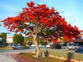
Royal Poinciana tree in full bloom in the فلوريدا كيز، دليل على المناخ المداري في جنوب فلوريدا.
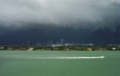
Typical summer afternoon shower from the Everglades traveling eastward over Miami Beach.
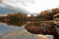
Fall foliage is a common sight in Central and North Florida starting around late November, and into Winter.
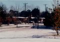
الثلج هو غير معتاد في فلوريدا،, but has occurred in every major Florida city at least once. Snow also falls occasionally in North Florida.
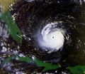
الإعصار أندرو يضرب فلوريدا في 23 أغسطس 1992.


الوحيش


Florida is host to many types of wildlife including:
- Marine mammals: bottlenose dolphin, short-finned pilot whale, North Atlantic right whale, West Indian manatee
- Mammals: Florida panther, northern river otter, mink, eastern cottontail rabbit, marsh rabbit, raccoon, striped skunk, squirrel, white-tailed deer, Key deer, bobcats, red fox, gray fox, coyote, wild boar, Florida black bear, nine-banded armadillos, Virginia opossum
- Reptiles: eastern diamondback and pygmy rattlesnakes, gopher tortoise, green and leatherback sea turtles,[32] brown anoles, and eastern indigo snake. In 2012, there were about one million American alligators and 1,500 crocodiles.[33]
- Birds: peregrine falcon,[34] bald eagle, American flamingo,[35] crested caracara, snail kite, osprey, white and brown pelicans, sea gulls, whooping and sandhill cranes, roseate spoonbill, American white ibis, Florida scrub jay (state endemic), and others. One subspecies of wild turkey, Meleagris gallopavo osceola, is found only in Florida.[36] The state is a wintering location for many species of eastern North American birds.
- As a result of climate change, there have been small numbers of several new species normally native to cooler areas to the north: snowy owls, snow buntings, harlequin ducks, and razorbills. These have been seen in the northern part of the state.[37]
- Invertebrates: carpenter ants, termites, American cockroach, Africanized bees, the Miami blue butterfly, and the grizzled mantis.
Florida also has more than 500 nonnative animal species and 1,000 nonnative insects found throughout the state.[38] Some exotic species living in Florida include the Burmese python, green iguana, veiled chameleon, Argentine black and white tegu, peacock bass, mayan cichlid, lionfish, White-nosed coati, rhesus macaque, vervet monkey, Cuban tree frog, cane toad, Indian peafowl, monk parakeet, tui parakeet, and many more. Some of these nonnative species do not pose a threat to any native species, but some do threaten the native species of Florida by living in the state and eating them.[39]


. . . . . . . . . . . . . . . . . . . . . . . . . . . . . . . . . . . . . . . . . . . . . . . . . . . . . . . . . . . . . . . . . . . . . . . . . . . . . . . . . . . . . . . . . . . . . . . . . . . . . . . . . . . . . . . . . . . . . . . . . . . . . . . . . . . . . . . . . . . . . . . . . . . . . . . . . . . . . . . . . . . . . . . .
النبيت

The state has more than 26,000 square miles (67,000 km2) of forests, covering about half of the state's land area.[40]
There are about 3,000 different types of wildflowers in Florida.[41] This is the third-most diverse state in the union, behind California and Texas, both larger states.[42] In Florida, wild populations of coconut palms extend up the East Coast from Key West to Jupiter Inlet, and up the West Coast from Marco Island to Sarasota. Many of the smallest coral islands in the Florida Keys are known to have abundant coconut palms sprouting from coconuts deposited by ocean currents. Coconut palms are cultivated north of south Florida to roughly Cocoa Beach on the East Coast and the Tampa Bay Area on the West Coast.[43]
On the east coast of the state, mangroves have normally dominated the coast from Cocoa Beach southward; salt marshes from St. Augustine northward. From St. Augustine south to Cocoa Beach, the coast fluctuates between the two, depending on the annual weather conditions.[37] All three mangrove species flower in the spring and early summer. Propagules fall from late summer through early autumn.[بحاجة لمصدر] Florida mangrove plant communities covered an estimated 430,000 to 540,000 acres (1,700 to 2,200 km2) in Florida in 1981. Ninety percent of the Florida mangroves are in southern Florida, in Collier, Lee, Miami-Dade and Monroe Counties.
رصيف فلوريدا المرجاني
.jpg&filetimestamp=20230607221837&)
The Florida Reef is the only living coral barrier reef in the continental United States.[44] It is also the third-largest coral barrier reef system in the world, after the Great Barrier Reef and the Belize Barrier Reef.[45] The reef lies a little bit off of the coast of the Florida Keys. A lot of the reef lies within John Pennekamp Coral Reef State Park, which was the first underwater park in the United States.[46] The park contains a lot of tropical vegetation, marine life, and seabirds. The Florida Reef extends into other parks and sanctuaries as well including Dry Tortugas National Park, Biscayne National Park, and the Florida Keys National Marine Sanctuary. Almost 1,400 species of marine plants and animals, including more than 40 species of stony corals and 500 species of fish, live on the Florida Reef.[47] The Florida Reef, being a delicate ecosystem like other coral reefs, faces many threats including overfishing, plastics in the ocean, coral bleaching, rising sea levels, and changes in sea surface temperature.
قضايا بيئية


Florida is a low per capita energy user.[48] اعتبارا من 2008[تحديث], it is estimated that approximately 4% of energy in the state is generated through renewable resources.[49] Florida's energy production is 6% of the nation's total energy output, while total production of pollutants is lower, with figures of 6% for nitrogen oxide, 5% for carbon dioxide, and 4% for sulfur dioxide.[49] Wildfires in Florida occur at all times of the year.[50]
All potable water resources have been controlled by the state government through five regional water authorities since 1972.[51]
Red tide has been an issue on the southwest coast of Florida, as well as other areas. While there has been a great deal of conjecture over the cause of the toxic algae bloom, there is no evidence that it is being caused by pollution or that there has been an increase in the duration or frequency of red tides.[52] Red tide is now killing off wildlife or Tropical fish and coral reefs putting all in danger.[53]
The Florida panther is close to extinction. A record 23 were killed in 2009, mainly by automobile collisions, leaving about 100 individuals in the wild. The Center for Biological Diversity and others have therefore called for a special protected area for the panther to be established.[54] Manatees are also dying at a rate higher than their reproduction.[55] American flamingos are rare to see in Florida due to being hunted in the 1900s, where it was to a point considered completely extirpated. Now the flamingos are reproducing toward making a comeback to South Florida since it is adamantly considered native to the state and also are now being protected.[56][57]
Much of Florida has an elevation of less than 12 feet (3.7 m), including many populated areas. Therefore, it is susceptible to rising sea levels associated with global warming.[58] The Atlantic beaches that are vital to the state's economy are being washed out to sea due to rising sea levels caused by climate change. The Miami beach area, close to the continental shelf, is running out of accessible offshore sand reserves.[59] Elevated temperatures can damage coral reefs, causing coral bleaching. The first recorded bleaching incident on the Florida Reef was in 1973. Incidents of bleaching have become more frequent in recent decades, in correlation with a rise in sea surface temperatures. White band disease has also adversely affected corals on the Florida Reef.[60]
الجيولوجيا

شبه جزيرة فلوريدا هي هضبة مسامية من كارست حجر جيري يجلس على ركيزة أساس تُعرف باسم رصيف فلوريدا.
The largest deposits of potash in the United States are found in Florida.[62] The largest deposits of rock phosphate in the country are found in Florida.[62] Most of this is in Bone Valley.[63]
Extended systems of underwater caves, sinkholes and springs are found throughout the state and supply most of the water used by residents.[64] The limestone is topped with sandy soils deposited as ancient beaches over millions of years as global sea levels rose and fell. During the last glacial period, lower sea levels and a drier climate revealed a much wider peninsula, largely savanna.[65] While there are sinkholes in much of the state, modern sinkholes have tended to be in West-Central Florida.[66][67] Everglades National Park covers 1,509,000 acres (6,110 km2), throughout Dade, Monroe, and Collier counties in Florida.[68] The Everglades, an enormously wide, slow-flowing river encompasses the southern tip of the peninsula. Sinkhole damage claims on property in the state exceeded a total of $2 billion from 2006 through 2010.[69] Winter Park Sinkhole, in central Florida, appeared May 8, 1981. It was approximately 350 feet (107 m) wide and 75 feet (23 m) deep. It was notable as one of the largest recent sinkholes to form in the United States. It is now known as Lake Rose.[70] The Econlockhatchee River (Econ River for short) is an 54.5-mile-long (87.7 km)[71] north-flowing blackwater tributary of the St. Johns River, the longest river in the U.S. state of Florida. The Econ River flows through Osceola, Orange, and Seminole counties in Central Florida, just east of the Orlando Metropolitan Area (east of State Road 417). It is a designated Outstanding Florida Waters.[72]
Earthquakes are rare because Florida is not located near any tectonic plate boundaries.[73]
المناطق

المدن والبلدات
The largest metropolitan area in the state as well as the entire southeastern United States is the Miami metropolitan area, with about 6.06 million people. The Tampa Bay Area, with more than 3.02 million, is the second largest; the Orlando metropolitan area, with more than 2.44 million, is third; and the Jacksonville metropolitan area, with more than 1.47 million, is fourth.[74]
Florida has 22 Metropolitan Statistical Areas (MSAs) defined by the United States Office of Management and Budget (OMB). Forty-three of Florida's 67 counties are in an MSA.
The legal name in Florida for a city, town or village is "municipality". In Florida there is no legal difference between towns, villages and cities.[75]
Florida is a highly urbanized state, with 89 percent of its population living in urban areas in 2000, compared to 79 percent nationally.[76]
In 2012, 75% of the population lived within 10 miles (16 km) of the coastline.[77]
| الترتيب | المقاطعة | التعداد | الترتيب | المقاطعة | التعداد | ||||
|---|---|---|---|---|---|---|---|---|---|
 جاكسونڤل  ميامي |
1 | جاكسونڤل | دوڤال | 949,611 | 11 | پمبروك پاينز، فلوريدا | براورد | 171,178 |  تامپا  أورلاندو |
| 2 | ميامي | ميامي-ديد | 442,241 | 12 | هوليوود | براورد | 153,067 | ||
| 3 | تامپا | هيلزبورو | 384,959 | 13 | غينزفيل | ألاتشوا | 141,085 | ||
| 4 | أورلاندو | أورانج | 307,573 | 14 | ميرامار | براورد | 134,721 | ||
| 5 | سانت بيترسبرغ | پينلاس | 258,308 | 15 | كورال سبرنغز | براورد | 134,394 | ||
| 6 | هياليا | ميامي-ديد | 223,109 | 16 | پالم باي | بريڤارد | 119,760 | ||
| 7 | پورت سانت لوسي | سانت لوسي | 204,851 | 17 | وست پالم بيتش | پالم بيتش | 117,415 | ||
| 8 | تالاهاسي | ليون | 196,169 | 18 | كليرواتر | پينلاس | 117,292 | ||
| 9 | كيپ كورال | لي | 194,016 | 19 | ليكلاند | پولك | 112,641 | ||
| 10 | فورت لودرديل | براورد | 182,760 | 20 | پومپانو بيتش | براورد | 112,046 | ||
التوزيع السكاني
السكان
| التعداد تاريخياً | |||
|---|---|---|---|
| الإحصاء | التعداد | %± | |
| 1830 | 34٬730 | ||
| 1840 | 54٬477 | 56.9% | |
| 1850 | 87٬445 | 60.5% | |
| 1860 | 140٬424 | 60.6% | |
| 1870 | 187٬748 | 33.7% | |
| 1880 | 269٬493 | 43.5% | |
| 1890 | 391٬422 | 45.2% | |
| 1900 | 528٬542 | 35.0% | |
| 1910 | 752٬619 | 42.4% | |
| 1920 | 968٬470 | 28.7% | |
| 1930 | 1٬468٬211 | 51.6% | |
| 1940 | 1٬897٬414 | 29.2% | |
| 1950 | 2٬771٬305 | 46.1% | |
| 1960 | 4٬951٬560 | 78.7% | |
| 1970 | 6٬789٬443 | 37.1% | |
| 1980 | 9٬746٬324 | 43.6% | |
| 1990 | 12٬937٬926 | 32.7% | |
| 2000 | 15٬982٬378 | 23.5% | |
| تقديري 2008 | 18٬328٬340 | 14.7% | |


المناطق الحضرية
أكبر المدن والبلدات
|
تعداد المدينة > 500,000
تعداد المدينة > 200,000
تعداد المدينة > 150,000
|
تعداد المدينة > 100,000
|


اللغات
In 1988, English was affirmed as the state's official language in the Florida Constitution. Spanish is also widely spoken, especially as immigration has continued from Latin America.[80] About twenty percent of the population speak Spanish as their first language. Twenty-seven percent of Florida's population reports speaking a mother language other than English, and more than 200 first languages other than English are spoken at home in the state.[81][82]
The most common languages spoken in Florida as a first language in 2010 are:[81]
- 73% English
- 20% Spanish
- 2% Haitian Creole
- Other languages less than 1% each
الدين


Florida is mostly Christian (70%),[83] although there is a large irreligious and relatively significant Jewish community. Protestants account for almost half of the population, but the Catholic Church is the largest single denomination in the state mainly due to its large Hispanic population and other groups like Haitians. Protestants are very diverse, although Baptists, Methodists, Pentecostals and nondenominational Protestants are the largest groups. Smaller Christian groups include The Church of Jesus Christ of Latter-day Saints and Jehovah's Witnesses. There is also a sizable Jewish community in South Florida. This is the largest Jewish population in the southern U.S. and the third-largest in the U.S. behind those of New York and California.[84]
In 2010, the three largest denominations in Florida were the Catholic Church, the Southern Baptist Convention, and the United Methodist Church.[85]
The Pew Research Center survey in 2014 gave the following religious makeup of Florida:[86]
الحكومة

| السنة | جمهوريون | ديمقراطيون |
|---|---|---|
| 2008 | 48.22% 4,045,624 | 50.96% 4,282,074 |
| 2004 | 52.10% 3,964,522 | 47.09% 3,583,544 |
| 2000 | 48.85% 2,912,790 | 48.84% 2,912,253 |
| 1996 | 42.32% 2,244,536 | 48.02% 2,546,870 |
| 1992 | 40.89% 2,173,310 | 39.00% 2,072,698 |
| 1988 | 60.87% 2,618,885 | 38.51% 1,656,701 |
| 1984 | 65.32% 2,730,350 | 34.66% 1,448,816 |
| 1980 | 55.52% 2,046,951 | 38.50% 1,419,475 |
| 1976 | 46.64% 1,469,531 | 51.93% 1,636,000 |
| 1972 | 71.91% 1,857,759 | 27.80% 718,117 |
| 1968 | 40.53% 886,804 | 30.93% 676,794 |
| 1964 | 48.85% 905,941 | 51.15% 948,540 |
| 1960 | 51.51% 795,476 | 48.49% 748,700 |
السياسة
الصحة

There were 2.7 million Medicaid patients in Florida in 2009. The governor has proposed adding $2.6 billion to care for the expected 300,000 additional patients in 2011.[88] The cost of caring for 2.3 million clients in 2010 was $18.8 billion.[89] This is nearly 30% of Florida's budget.[90] Medicaid paid for 60% of all births in Florida in 2009. The state has a program for those not covered by Medicaid.
In 2013, Florida refused to participate in providing coverage for the uninsured under the Affordable Care Act, colloquially called Obamacare. The Florida legislature also refused to accept additional Federal funding for Medicaid, although this would have helped its constituents at no cost to the state. As a result, Florida is second only to Texas in the percentage of its citizens without health insurance.[91]
العمارة

Florida has the largest collection of Art Deco and Streamline Moderne buildings, both in the United States and in the entire world, most of which are located in the Miami metropolitan area, especially Miami Beach's Art Deco District, constructed as the city was becoming a resort destination.[92] A unique architectural design found only in Florida is the post-World War II Miami Modern, which can be seen in areas such as Miami's MiMo Historic District.[93]
Being of early importance as a regional center of banking and finance, the architecture of Jacksonville displays a wide variety of styles and design principles. Many of the state's earliest skyscrapers were constructed in Jacksonville, dating as far back as 1902,[94] and last holding a state height record from 1974 to 1981.[95] The city is endowed with one of the largest collections of Prairie School buildings outside of the Midwest.[96] Jacksonville is also noteworthy for its collection of Mid-Century modern architecture.[97]
Some sections of the state feature architectural styles including Spanish revival, Florida vernacular, and Mediterranean Revival.[98] A notable collection of these styles can be found in St. Augustine, the oldest continuously occupied European-established settlement within the borders of the United States.[99]
الإقتصاد


تمــثل تجــارة الجمـــلة، وتجـــارة التــجزئة النشاط الاقتصادي الرئيسي في فلوريدا. ويستوعب هذا النشاط 27% من القوى العاملة بالولاية. وتُعد تجارة التجزئة أهم من تجارة الجملة في فلوريدا. وأكثر أنواع مؤسسات تجارة التجزئة أهمية في الولاية سماسرة السيارات ومتاجر البقالة. كما أن لتجارة الجملة في منتجات النفط والحمضيات شأن عظيم في فلوريدا.
تستوعب خدمات الجمهور أو الخدمات الاجتماعية والشخصية، والنشــاطات الأخرى 25% من القوى العاملة بالولاية. ومن أمثلة هذه الأنشطة إدارة متنزهات الملاهي والفنادق والمدارس الخاصة والمستشفيات، وورش التصليح.
ولقد نمت الأعمال المالية وأعمال التأمين وإدارة العقار مع التزايد السريع في أعداد السكان بالولاية. وتلْقى شركات المال والتأمين مصادر استثمار مهمة في فلوريدا نظرًا لأن أعداد الأشخاص المتقاعدين فيها كبيرة. وتتــبوأ كل من جاكسونفيل وميامي مركز الصدارة في شؤون التأمين والمصارف. تُعد منطقة ميامي-فورت لودرديل أهم منطقة صناعية استفادت من نمو برنامج الحكومة الفيدرالية الدفاعي، فصارت معدات طيران الفضاء، ووسائل الاتصال العسكري أهم المنتجات الصناعية. بالإضافة إلى ذلك، فإن تعليب الحمضيات صناعة مهمة أيضًا في فلوريدا. ومن مراكز الصناعة الأخرى تامبا، جاكسونفيل واورلاندو.
تمثل المحاصيل الزراعية نحو 80% من مجموع دخل فلوريدا من المزارع. ويعتبر البرتقال أهم منتجات هذه المزارع. أما الحمضيات الأخرى التي تُزرع في هذه الولاية فمن أهمها الجريب فروت والليمون الحمضي والتنغرين والطنجال.
وأهم خضراوات فلوريدا الطماطم، وهي المحصول الزراعي الثاني من حيث الأهمية. ويعتمد كثير من الولايات في شمال الولايات المتحدة على خضراوات فلوريدا الطازجة خصوصًا في الأشهر الباردة. وقصب الــسكر محصول آخر مهم في فلوريدا، حيث تعتبر الولاية الأولى في إنتاجه. وتأتي فلوريدا في المرتبة الثانية بعد كاليفورنيا في إنتاج محاصيل البيوت المحمية والمشاتل. كما يوجد في هذه الولاية ثلاثة أرباع ما تنتجه الولايات المتحدة من صخور الفوسفات.
تتصدر فلوريدا أيضًا في تجارة الأسماك حيث تُصاد في مياهها أنواع مختلفة من الأسماك مثل الروبيان والكركند والمحار المروحي.
تمر عبر مطار ميامي الدولي أكثر طائرات الركاب والبضائع الذاهبة إلى أمريكا اللاتينية والقادمة منها. لذا فإنه غالبًا ما يطلق على ميامي اسم بوابة أمريكا اللاتينية. في فلوريدا 15 ميناء عميقاً كلها تعمل موانئ دخول ومغـادرة للولايــات المتحدة. وتامبا الميناء الرئيسي في الولاية.
التعليم
In 2020, Florida was ranked the third best state in America for K-12 education, outperforming the nation in 15 out of 18 metrics in Education Week's 2020 Quality Counts report.[100] In terms of K-12 Achievement, which measures progress in areas such as academic excellence and graduation rates, the state was graded "B-" compared to a national average of C.[100] Florida's higher education was ranked first and pre-K-12 was ranked 27th best nationwide by U.S. News & World Report.[101]
التعليم العالي
The State University System of Florida was founded in 1905, and is governed by the Florida Board of Governors. During the 2019 academic year, 346,604 students attended one of these twelve universities.[102] In 2016, Florida charged the second lowest tuition in the nation for four-year programs, at $26,000 for in-state students and $86,000 for out-of-state students; this compares with an average of $34,800 nationally for in-state students.[103]
As of 2020, three Florida universities are among the top 10 largest universities by enrollment in the United States: The University of Central Florida in Orlando (2nd), the University of Florida in Gainesville (4th), and Florida International University in Miami (8th).
The Florida College System comprises 28 public community and state colleges with 68 campuses spread out throughout the state. In 2016, enrollment exceeded 813,000 students.[104]
The Independent Colleges and Universities of Florida is an association of 30 private, educational institutions in the state.[105] This Association reported that their member institutions served more than 158,000 students in the fall of 2020.[106]
University of Miami in Coral Gables is one of the nation's top private research universities. Florida's first private university, Stetson University in DeLand, was founded in 1883.


النقل
الطرق السريعة

Florida's interstates, state highways and U.S. Highways are maintained by the Florida Department of Transportation. Florida's interstate highway system contains 1,473 miles (2,371 km) of highway, and there are 9,934 miles (15,987 km) of non-interstate highway in the state, such as Florida state highways and U.S. Highways.
الطرق الرئيسية العابرة للولايات في فلوريدا تتضمن:
 I-4, which bisects the state, connecting Tampa, Lakeland, اورلاندو, and Daytona Beach, connecting with I-95 in Daytona Beach and I-75 in Tampa.
 I-10, which traverses the panhandle, connecting Jacksonville, Lake City, تلاهاسي and Pensacola, with junctions with I-95 in Jacksonville and I-75 in Lake City.
 I-75, which enters the state near Lake City (45 miles west of Jacksonville) and continues southward through Gainesville, Ocala, Tampa's eastern suburbs, Bradenton, Sarasota, Fort Myers and Naples, where it crosses the "Alligator Alley" as a toll road to فورت لودرديل before turning southward and terminating in Hialeah/Miami Lakes having junctions with I-10 in Lake City and I-4 in Tampa.
 I-95, which enters the state near Jacksonville and continues along the Atlantic Coast through Daytona Beach Melbourne/Titusville, Palm Bay, Vero Beach, Fort Pierce, Port Saint Lucie, Stuart, West Palm Beach, and فورت لودرديل before terminating in Downtown Miami, with junctions with I-10 in Jacksonville and I-4 in Daytona Beach.

Prior to the construction of routes under the Federal Aid Highway Act of 1956, Florida began construction of a long cross-state toll road, Florida's Turnpike. The first section, from Fort Pierce south to the Golden Glades Interchange was completed in 1957. After a second section north through Orlando to Wildwood (near present-day The Villages), and a southward extension around Miami to Homestead, it was finished in 1974.
State highways are numbered in a specific order. The first digits of state highways, with some exceptions, such as State Road 112 connecting Interstate 95 to the Miami International Airport or State Road 15 في اورلاندو، مرقمة with the first digit indicating what area of the state the road is in, from 1 in the north to 9 in the south. North-South Florida State Roads are generally odd numbered increasingly from east to west, and East-West Florida State Roads are even numbered increasingly from north to south. Following this convention, State Road 907, or Alton Rd. on Miami Beach, is farther east than State Road 997, which is Krome Ave, or the farthest west north-south road in Miami-Dade County. The other notable exception to this rule is State Road 826, or the Palmetto Expressway (pictured at the right heading north) which although is even numbered, is labeled north to south. State roads can have anywhere from one to four digits depending on the importance and location of the road.[107] County roads often follow this same system.
السكك الحديدية بين المدن

Florida is served by Amtrak: Sanford, in Greater Orlando, is the southern terminus of the Amtrak Auto Train, which originates at Lorton, Virginia, south of Washington, DC. Orlando is also the eastern terminus of the Sunset Limited, which travels across the southern United States via New Orleans, Houston, and San Antonio to its western terminus of Los Angeles. Florida is served by two additional Amtrak trains (the Silver Star and the Silver Meteor), التي تعمل بين مدينة نيويورك وميامي.
المطارات
المطارات الدولية الكبرى في فلوريدا التي مر عبر كل منها أكثر من 15 مليون مسافر في 2006 هي مطار اورلاندو الدولي (34,128,048), مطار ميامي الدولي (32,533,974), مطار فورت لودرديل-هوليوود الدولي(21,369,577) ومطار تامپا الدولي (18,867,541).
Secondary airports, with annual passenger traffic exceeding 5 million each in 2006, include مطار جنوب غرب فلوريدا الدولي (Fort Myers) (7,643,217), مطار پالم بيتش الدولي (West Palm Beach) (7,014,237),[108] and مطار جاكسونفيل الدولي (5,946,188).
Regional Airports which processed over one million passengers each in 2006 are Pensacola (1,620,198) and Sarasota-Bradenton (1,423,113). Sanford, which is primarily served by international charter airlines processed 1,649,565 passengers in 2006.[109]
الرياضة


مدن شقيقة
| الدائرة الشقيقة | البلد | السنة[110] |
|---|---|---|
| كيونگگي | 2000 | |
| لانگدوك-روسيون | 1989 | |
| نويڤا إسپرطة | 1999 | |
| مقاطعة تايوان | 1992 | |
| محافظة واكاياما | 1995 | |
| الكاپ الغربي | 1995 |
انظر أيضا
- Index of Florida-related articles
- Outline of Florida
- List of people from Florida
- USS فلوريدا, 6 ships
ملاحظات
- ^ Elevation adjusted to North American Vertical Datum of 1988
المصادر
- ^ "Florida | Map, Population, History, & Facts". Encyclopedia Britannica. Archived from the original on July 5, 2020. Retrieved June 30, 2020.
- ^ "Florida | State Facts & History". www.infoplease.com. Archived from the original on June 30, 2020. Retrieved June 30, 2020.
- ^ "Florida". www.americaslibrary.gov. Archived from the original on April 27, 2020. Retrieved June 30, 2020.
- ^ "State Motto". Florida Department of State. Archived from the original on January 21, 2016. Retrieved September 14, 2018.
- ^ "United States Summary: 2010. Population and Housing Unit Counts. 2010 Census of Population and Housing" (PDF). مكتب تعداد الولايات المتحدة. September 2012. p. 41. Archived (PDF) from the original on October 19, 2012. Retrieved April 9, 2019.
- ^ أ ب "Elevations and Distances in the United States". United States Geological Survey. 2001. Archived from the original on October 15, 2011. Retrieved October 21, 2011.
- ^ "U.S. Census Bureau QuickFacts Florida". U.S. Census Bureau, 2022 Estimate. Retrieved January 2, 2023.
- ^ "US Census Bureau QuickFacts". United States Census Bureau. Archived from the original on May 9, 2022. Retrieved April 30, 2022.
- ^ خطأ استشهاد: وسم
<ref>غير صحيح؛ لا نص تم توفيره للمراجع المسماةArticle 2, Section 9, Constitution of the State of Florida - ^ "Languages Spoken at Home in Florida". United States Census Bureau. Retrieved January 2, 2022.
- ^ أ ب "SB 230—State Symbols/Fla. Cracker Horse/Loggerhead Turtle [RPCC]". Florida House of Representatives. Archived from the original on August 19, 2014. Retrieved April 7, 2012.
- ^ "Cérémonies et Coutumes Religieuses de tous les Peuples du Monde"
- ^ Dunbar, James S. "The pre-Clovis occupation of Florida: The Page-Ladson and Wakulla Springs Lodge Data". Archived from the original on October 12, 2014. Retrieved June 23, 2011.
- ^ "16th Century Settlements - Florida Department of State". dos.myflorida.com. Retrieved 12 November 2022.
- ^ Ritter, Michael. "Wet/Dry Tropical Climate". University of Wisconsin, Stevens Point. Archived from the original on November 24, 2010. Retrieved July 18, 2007.
- ^ "Average Annual Temperature for Each US State". Current Results Nexus. Archived from the original on August 27, 2011. Retrieved August 19, 2011.
- ^ "Hottest States in the US—Current Results". Currentresults.com. Archived from the original on April 9, 2022. Retrieved May 9, 2022.
- ^ "Cold Weather Hazards". National Weather Service Miami, Florida. Archived from the original on June 19, 2018. Retrieved June 19, 2018.
- ^ "Hazardous Weather: A Florida Guide—Temperatures". FloridaDisaster.org. Archived from the original on June 19, 2016. Retrieved October 9, 2016.
- ^ "Temperature Extremes". Mymanatee.org. June 11, 2012. Archived from the original on September 7, 2016. Retrieved October 9, 2016.
- ^ "Has It Ever Snowed in Florida?". Worldatlas.com. October 25, 2017. Archived from the original on April 9, 2022. Retrieved May 9, 2022.
- ^ Geggis, Anne (January 2, 2018). "Brrrrr! South Florida may see frost by week's end". Sun-sentinel.com. Archived from the original on November 12, 2020. Retrieved May 9, 2022.
- ^ United States National Arboretum. "Florida Hardiness Zones". St Johns River Water Management District. Archived from the original on July 16, 2011. Retrieved March 25, 2011.
- ^ "Dense Fog Advisory". miami.cbslocal.com. Archived from the original on February 4, 2021. Retrieved May 9, 2022.
- ^ "JACKSONVILLE WSO AP, FLORIDA—Climate Summary". Southeast Regional Climate Center. Retrieved 2008-01-26.
- ^ "KEY WEST WSO AIRPORT, FLORIDA—Climate Summary". Southeast Regional Climate Center. Retrieved 2008-01-26.
- ^ "MELBOURNE WSO, FLORIDA—Climate Summary". Southeast Regional Climate Center. Retrieved 2008-01-26.
- ^ "MIAMI WSCMO AIRPORT, FLORIDA—Climate Summary". Southeast Regional Climate Center. Retrieved 2008-01-26.
- ^ "PENSACOLA FAA ARPT, FLORIDA—Climate Summary". Southeast Regional Climate Center. Retrieved 2008-01-26.
- ^ "TALLAHASSEE WSO AP, FLORIDA—Climate Summary". Southeast Regional Climate Center. Retrieved 2008-01-26.
- ^ "TAMPA WSCMO ARPT, FLORIDA—Climate Summary". Southeast Regional Climate Center. Retrieved 2008-01-26.
- ^ "Leatherback Nesting in Florida". myfwc.com. Archived from the original on October 31, 2020. Retrieved May 9, 2022.
- ^ Morgan, Curtis (April 9, 2012). "Crocs crawl back to coast". Florida Today. Melbourne, Florida. pp. 8B. Archived from the original on April 10, 2012.
- ^ Winston, Keith (December 24, 2013). "Predator animals rebound". Florida Today. Melbourne, Florida. pp. 7B. Archived from the original on March 16, 2015. Retrieved December 29, 2013.
- ^ "Surprising Origin of American Flamingos Discovered". News.mationalgeographic.com. March 10, 2018. Archived from the original on June 12, 2018. Retrieved May 9, 2022.
- ^ C. Michael Hogan. 2008. Wild turkey: Meleagris gallopavo, GlobalTwitcher.com, ed. N. Stromberg Archived يوليو 25, 2017 at the Wayback Machine
- ^ أ ب Winsten, Keith (January 7, 2014). "'Snow' bird species in South". Florida Today. Melbourne, Florida. pp. 7B. Archived from the original on January 9, 2014. Retrieved January 7, 2014.
- ^ "BIOLOGICAL CONTROL OF INVASIVE INSECT PESTS OF CROPS AND NATIVE FLORA IN FLORIDA". Usda.gov/. Archived from the original on February 4, 2021. Retrieved June 3, 2018.
- ^ "Nonnative Species". myfwc.com. Archived from the original on February 13, 2021. Retrieved May 17, 2018.
- ^ Waymer, Jim (April 1, 2020). "Florida forests help roll out toilet paper". Florida Today. Melbourne, Florida. pp. 1A, 10A. Archived from the original on April 3, 2020. Retrieved April 4, 2020.
- ^ "Native Plants—University of Florida, Institute of Food and Agricultural Sciences". gardeningsolutions.ifas.ufl.edu. Archived from the original on February 1, 2021. Retrieved May 9, 2022.
- ^ Sonnenberg, Maria (September 21, 2013). "Florida's flowers". Florida Today. Melbourne, Florida. p. 1D. Archived from the original on March 16, 2015. Retrieved September 21, 2013.
- ^ Crane, Timothy K. Broschat and Jonathan H. (April 4, 2018). "The Coconut Palm in Florida". edis.ifas.ufl.edu. Archived from the original on February 9, 2021. Retrieved May 9, 2022.
- ^ "The biggest coral reef in the continental U.S. is dissolving into the ocean". Washington Post. Archived from the original on February 4, 2021. Retrieved May 9, 2022.
- ^ US Department of Commerce, National Oceanic and Atmospheric Administration. "NOAA CoRIS—Regional Portal—Florida". www.coris.noaa.gov. Archived from the original on June 5, 2019. Retrieved May 19, 2019.
- ^ "About—Pennekamp Coral Reef State Park". pennekamppark.com. Archived from the original on February 6, 2015. Retrieved May 19, 2019.
- ^ "SOFIA—Circular 1134—the Natural System—Florida Reef Tract". archive.usgs.gov. Archived from the original on July 31, 2020. Retrieved May 19, 2019.
- ^ خطأ استشهاد: وسم
<ref>غير صحيح؛ لا نص تم توفيره للمراجع المسماةEnergy Consumption by Source and Total Consumption per Capita, Ranked by State, 2004 - ^ أ ب خطأ استشهاد: وسم
<ref>غير صحيح؛ لا نص تم توفيره للمراجع المسماةDoE-profile - ^ "Current Wildfire Conditions / Wildland Fire / Florida Forest Service / Divisions & Offices / Home—Florida Department of Agriculture & Consumer Services". Freshfromflorida.com. Archived from the original on February 2, 2019. Retrieved October 23, 2018.
- ^ "Florida Statutes". Leg.state.fl.us. Archived from the original on October 31, 2005. Retrieved November 4, 2011.
- ^ خطأ استشهاد: وسم
<ref>غير صحيح؛ لا نص تم توفيره للمراجع المسماةTide's toxins trouble lungs ashore - ^ "Why Florida's red tide is killing fish, manatees, and turtles". Vox.com. August 30, 2018. Archived from the original on April 16, 2022. Retrieved May 9, 2022.
- ^ خطأ استشهاد: وسم
<ref>غير صحيح؛ لا نص تم توفيره للمراجع المسماةRecord number of panthers killed by vehicles in 2009 - ^ "More manatees have died in Florida so far this year than in all of 2017. Here's why". Miamiherald.com. Archived from the original on August 18, 2021. Retrieved May 9, 2022.
- ^ "Florida's Long-Lost Wild Flamingos Were Hiding in Plain Sight". Npr.org. Archived from the original on April 9, 2022. Retrieved May 9, 2022.
- ^ "Now that we agree these flamingos are Florida natives, it's time to protect them, experts say". Miamiherald.com. Archived from the original on August 27, 2021. Retrieved May 9, 2022.
- ^ Jeff Goodell (June 20, 2013). "Goodbye, Miami". Rolling Stone. Archived from the original on May 10, 2018. Retrieved June 21, 2013.
- ^ "Where Sand Is Gold, the Reserves Are Running Dry". The New York Times. August 25, 2013. Archived from the original on November 12, 2020. Retrieved February 16, 2017.
- ^ Precht and Miller:243–44, 245, 247–48, 249
The State of Coral Reef Ecosystems of the Florida Keys Archived أغسطس 11, 2010 at the Wayback Machine Accessed December 17, 2010 - ^ Wilkinson, Jerry. "History of Keys Geology". Keyshistory.org. Archived from the original on November 9, 2020. Retrieved May 9, 2022.
- ^ أ ب خطأ استشهاد: وسم
<ref>غير صحيح؛ لا نص تم توفيره للمراجع المسماةIndustry overview - ^ Parsons, Victoria (Spring 2011). "The Real Cost of Fertilizer". Bay Soundings. Archived from the original on March 24, 2015. Retrieved June 21, 2014.
- ^ "Florida Springs, Springs in Florida, Florida Cave Diving—Florida's Springs: Protecting Nature's Gems—Florida DEP—Springshed Map". February 11, 2011. Archived from the original on February 11, 2011. Retrieved May 19, 2019.
- ^ خطأ استشهاد: وسم
<ref>غير صحيح؛ لا نص تم توفيره للمراجع المسماةFlorida's Geological History - ^ Tihansky, Ann B. "Sinkholes, West-Central Florida. A link between surface water and ground water" (PDF). U.S. Geological Survey, Tampa, Florida. Archived (PDF) from the original on October 25, 2011. Retrieved June 21, 2014.
- ^ "Sinkhole Maps of Florida Counties". Florida Center for Instructional Technology, College of Education. University of South Florida. 2007. Archived from the original on April 10, 2013. Retrieved June 21, 2014.
- ^ "The National Parks: Index 2012–2016" (PDF). nps.gov. National Park Service. p. 47. Archived (PDF) from the original on 13 November 2018. Retrieved November 19, 2018.
- ^ "State Farm seeks 28% rate hike". Florida Today. Melbourne, Florida. February 16, 2011. p. 8B. Archived from the original on February 19, 2011.
- ^ Huber, Red (November 13, 2012). "Looking back at Winter Park's famous sinkhole". Orlando Sentinel. Archived from the original on January 17, 2021. Retrieved May 9, 2022.
- ^ U.S. Geological Survey. National Hydrography Dataset high-resolution flowline data. The National Map Archived مارس 29, 2012 at the Wayback Machine, accessed April 21, 2011
- ^ (2013-01-02). "Econlockhatchee River" Archived يوليو 5, 2017 at the Wayback Machine. Saint Johns River Water Management District. Retrieved on August 4, 2014.
- ^ "Florida's Earthquake History and Tectonic Setting". Decodedscience.org. January 23, 2015. Archived from the original on September 3, 2018. Retrieved May 9, 2022.
- ^ Millsap, Adam. "Big Metro Areas in Florida Keep Getting Bigger". Forbes.com. Archived from the original on April 9, 2022. Retrieved May 9, 2022.
- ^ "Local Government Vocabulary". Florida League of Cities. Archived from the original on November 10, 2013. Retrieved May 15, 2012.
- ^ "Population data" (PDF). bebr.ufl.edu. 2005. Archived (PDF) from the original on December 12, 2019. Retrieved November 9, 2019.
- ^ Fishkind, Hank (November 9, 2013). "Beaches are critically important to us". Florida Today. Melbourne, Florida. pp. 4B. Archived from the original on March 16, 2015. Retrieved November 11, 2013.
- ^ "2020 Decennial US Census". 2020 US Census. November 2021. Archived from the original on December 8, 2021. Retrieved November 26, 2021.
- ^ World skyline rankings
- ^ "Immigrants in Florida". Americanmigrationcouncil.org. January 1, 2015. Archived from the original on February 4, 2021. Retrieved May 9, 2022.
- ^ أ ب "Florida". Modern Language Association. Archived from the original on December 1, 2007. Retrieved August 11, 2013.
- ^ MacDonald, Victoria M. (April 2004). "The Status of English Language Learners in Florida: Trends and Prospects" (PDF). Education Policy Research Unit, Arizona State University. Archived from the original (PDF) on February 9, 2014. Retrieved May 24, 2013.
- ^ أ ب "Religious Landscape Study". Pew Forum. May 11, 2015. Archived from the original on November 24, 2020. Retrieved June 7, 2015.
- ^ "Jewish Population of the United States, by State (2011)". Jewish Virtual Library. Archived from the original on January 21, 2017. Retrieved September 13, 2013.
- ^ "The Association of Religion Data Archives | State Membership Report". www.thearda.com. Archived from the original on December 2, 2013. Retrieved November 15, 2013.
- ^ Pew Research Center, "Religious Landscape Study: Florida" Archived نوفمبر 24, 2020 at the Wayback Machine
- ^ "100 of the largest hospitals and health systems in America," Becker's Hospital Review
- ^ خطأ استشهاد: وسم
<ref>غير صحيح؛ لا نص تم توفيره للمراجع المسماةCounty Medicaid tab rises, could get worse - ^ Ryan, MacKenzie (December 26, 2010). "Qualifying for care a minefield" (PDF). Florida Today. Melbourne, Florida. p. 3A. Archived from the original (PDF) on December 5, 2010.
- ^ Marshal, James (December 26, 2010). "Sunday debate: No: Longtime official lost touch with voters". Florida Today. Melbourne, Florida. p. 19A. Archived from the original on August 21, 2013.
- ^ Bureau, US Census. "Health Insurance Coverage in the United States: 2013". Census.gov. Retrieved 12 November 2022.
- ^ "Miami Beach". Bass Museum of Art. Archived from the original on November 22, 2010.
- ^ "Tour Miami's Art Deco District—MiamiAndBeaches.com—Miami and The Beaches". September 18, 2018. Archived from the original on September 18, 2018. Retrieved May 19, 2019.
- ^ Ennis Davis (March 6, 2008). "A Century of Florida's Tallest Skyscrapers". Metro Jacksonville. Archived from the original on May 25, 2017. Retrieved April 12, 2016.
- ^ "Wells Fargo Center, Jacksonville". Emporis. Archived from the original on May 9, 2016. Retrieved April 12, 2016.
- ^ Wayne W. Wood. "Jacksonville's Lost Treasures". Prairie School Traveler. Archived from the original on May 25, 2017. Retrieved April 23, 2016.
- ^ "When Does Modern Architecture Become Historic?". Jacksonville Historical Society. Archived from the original on August 26, 2016. Retrieved April 23, 2016.
- ^ "Official: Design rules haven't cost Palm Bay new businesses". Florida Today. Archived from the original on August 25, 2013. Retrieved June 1, 2009.
- ^ "Florida: St. Augustine Town Plan Historic District". National Park Service. Archived from the original on April 30, 2015. Retrieved May 8, 2016.
- ^ أ ب Solodev (October 16, 2020). "Florida Moves Up in National Ranking". www.fldoe.org (in الإنجليزية). Retrieved June 28, 2022.
- ^ "Rankings". www.usnews.com. Archived from the original on April 13, 2021. Retrieved April 13, 2021.
- ^ "Accountability plan" (PDF). www.flbog.edu. 2020. Archived (PDF) from the original on May 17, 2021. Retrieved April 13, 2021.
- ^ "Higher education in Britain is still good value compared with America". Economist. March 2, 2017. Archived from the original on March 2, 2017. Retrieved March 2, 2017.
- ^ "Factbook" (PDF). www.fldoe.org. 2016. Archived (PDF) from the original on May 15, 2021. Retrieved April 13, 2021.
- ^ "Official website of ICUF". Icuf.org. Archived from the original on May 29, 2010. Retrieved November 4, 2011.
- ^ "ICUF – Independent Colleges and Universities of Florida". Archived from the original on February 24, 2021. Retrieved March 9, 2021.
- ^ FHP State Road Listings accessed March 29, 2009
- ^ 2005 figure; 2006 data not available.
- ^ "2006 North America Airports Traffic Statistics". Airports Council International. Retrieved 2007-10-18.
- ^ "Florida Sister City/Sister State Directory 2001" (PDF). State of Florida. 2001. Retrieved 2009-02-12.
روابط خارجية
- الموقع الإلكتروني للولاية
- فلوريدا at the Open Directory Project
- Florida State Guide, from the Library of Congress
فلوريدا travel guide from Wikitravel
- Florida Memory Project Over 300,000 photographs and documents from the State Library & Archives of Florida
- Online collection of the Spanish Land Grants.
- USGS real-time, geographic, and other scientific resources of Florida
- University of Florida Digital Collections Digital collections of texts and images, including Florida aerial photography, ephemeral photographs and postcards, letters, and more
- U.S. Census Bureau
- Economic and farm demographics fact sheet from the USDA
- Energy & Environmental Data For Florida
- List of searchable databases produced by Florida state agencies hosted by the American Library Association Government Documents Roundtable
- Heliconius charitonia, zebra longwing Florida state butterfly, on the UF / IFAS Featured Creatures Web site
- Florida stone quarry information on Stone Quarries and Beyond
- “Scenes in Florida,” in Picturesque America, with Illustrations, by Harry Fenn, 1872, on Stone Quarries and Beyond.
- Florida Wiki
- Florida Rivers and Watersheds - Florida DEP
| سبقه Michigan |
List of U.S. states by date of statehood Admitted on March 3, 1845 (27th) |
تبعه Texas |
أماكن قريبة من فلوريدا | ||||||||||
|---|---|---|---|---|---|---|---|---|---|---|
| ||||||||||
قالب:Protected areas of Florida
| ||||||||||||||

.jpg&filetimestamp=20230607221837)
- Short description matches Wikidata
- Short description is different from Wikidata
- صفحات تستخدم جدول مستوطنة بقائمة محتملة لصفات المواطن
- Pages using infobox settlement with no coordinates
- Articles with hatnote templates targeting a nonexistent page
- Articles with unsourced statements from October 2018
- مقالات فيها عبارات متقادمة منذ 2008
- جميع المقالات التي فيها عبارات متقادمة
- Pages using bar box without float left or float right
- Coordinates on Wikidata
- فلوريدا
- ولايات الولايات المتحدة الأمريكية
- الولايات المتحدة الجنوبية
- Confederate states (1861-1865)
- مستعمرات بريطانية سابقة
- مستعمرات إسپانية سابقة
- دول وأراضي تأسست في 1845
- States and territories established in 1845
- States of the Confederate States of America
- States of the East Coast of the United States
- States of the Gulf Coast of the United States
- States of the United States
- الولايات المتحدة المتجاورة