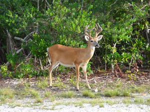
فلوريدا كيز

فلُورِيدَا كِيِز Florida Keys مجموعة جزر صغيرة أو سلاسل صخرية تشكل جزءًا من فلُورِيدَا الجنوبية بالولايات المتحدة الأمريكية. تمتد فلوريدا كيز في خط منحن إلى 240كم طولاً من خليج بيسكَاين في الجنوب الغربي إلى داخل خليج المَكْسِيك ـ جاء اسم كيز من كلمة أسبانية بمعنى جزيرة صغيرة. وفلوريداكيز نماذج مهمة للتكوين المرجاني. وتتمتع بحركة سياحية رائجة. تشمل الصناعات فيها الإسفنج، والسيجار ومعامل التعليب. أهم مرفأ بها هو كي ويست، ويوجد في أقصى طرف اليابسة. ويربطها باليابسة طريق عام خارجي، يبلغ طوله 206كم.
. . . . . . . . . . . . . . . . . . . . . . . . . . . . . . . . . . . . . . . . . . . . . . . . . . . . . . . . . . . . . . . . . . . . . . . . . . . . . . . . . . . . . . . . . . . . . . . . . . . . . . . . . . . . . . . . . . . . . . . . . . . . . . . . . . . . . . . . . . . . . . . . . . . . . . . . . . . . . . . . . . . . . . . .
الجيولوجيا
البيئة

الجزر الكبرى


انظر أيضًا
الهامش
مصادر أخرى
- Jeff, Ripple (1995). The Florida Keys: the Natural Wonders of an Island Paradise, Photographs by Bill Keogh, Stillwater, منيسوتا: Voyageur Press. ISBN 0-89658-262-0.
- Jason Project The Story of Water Movement and Land Formation - accessed January 28 2006
- About the Florida Keys
وصلات خارجية
- A Gazetteer of the Florida Keys
- Florida Keys travel guide from Wikitravel
- City of Key West
- City of Marathon
- Historical photographs of the Florida Keys
- History of the Conch Republic
- National Park Service: Dry Tortugas
- NOAA Marine Sanctuary
الوسائط
Coordinates: 24°40′01″N 81°32′39″W / 24.66694°N 81.54417°W


