أريزونا


ولاية أريزونا Arizona، في المنطقة الجنوبية الغربية من الولايات المتحدة الأمريكية الجنوبية الغربية وهي تلمس ولاية كاليفورنيا، ولاية كولورادو، وولاية نيفادا، ولاية نيو مكسيكو، وولاية يوتا، ودولة المكسيك. بلغ سكان أريزونا 6,000,000 والعاصمة هي فينكس. المدن الكبيرة في أريزونا هي فينكس وتوسن وميسا وتمبي. وأيضاً في أريزونا أرض للهنود الحمر، مثل النافاهو والهوبي. السياحة والزراعة والتربية مهمة للإقصاد، وفي أراضي الهنود الحمر أصبحت كازينوهات القمار المصدر الرئيسي للدخل لمجلس القبيلة. الطقس الأريزوني هو جيد ومشمس كل الوقت. حاكمة الولاية هي جانت نابوليتانو وشيوخ الولاية في الكونغرس هم جون مكين ودجون كيل. بعض المشاهير من أريزونا هم ساندرة دي أو كانر وهي قاضة كبيرة في المحكمة العليا، وباري غولدواتر وكان مرشحا للرئاسة ، وأليس كوبر وهو موسيقار، وسيزار شافيز وهو مدافع عن حقوق العمال الزراعيين.
تتميز أريزونا بمناخها الصحراوي الدافئ الجاف الذي يجذب إليها الكثير من الناس، حتى أصبحت هذه الولاية واحدة من أسرع المناطق نموّاً. يعيش أكثر من نصف السكان في فينكس، عاصمة أريزونا كبرى مدنها. تغطي الأراضي المخصصة للهنود ربع أرض أريزونا، ويعيش بعض الهنود في مجتمعات تأسست منذ أكثر من 800 سنة. ويعيش الكثير من الأمريكيين ذوي الأصل المكسيكي أيضًا في أريزونا، ويظهر تأثيرهم في العادات والأطعمة وأسماء الأماكن.
Arizona is the 48th state and last of the contiguous states to be admitted to the Union, achieving statehood on February 14, 1912. Historically part of the territory of Alta California in New Spain, it became part of independent Mexico in 1821. After being defeated in the Mexican–American War, Mexico ceded much of this territory to the United States in 1848, where the area became part of the territory of New Mexico. The southernmost portion of the state was acquired in 1853 through the Gadsden Purchase.
Southern Arizona is known for its desert climate, with very hot summers and mild winters. Northern Arizona features forests of pine, Douglas fir, and spruce trees; the Colorado Plateau; mountain ranges (such as the San Francisco Mountains); as well as large, deep canyons, with much more moderate summer temperatures and significant winter snowfalls. There are ski resorts in the areas of Flagstaff, Sunrise, and Tucson. In addition to the internationally known Grand Canyon National Park, which is one of the world's seven natural wonders, there are several national forests, national parks, and national monuments.
Arizona's population and economy have grown dramatically since the 1950s because of inward migration, and the state is now a major hub of the Sun Belt. Cities such as Phoenix and Tucson have developed large, sprawling suburban areas. Many large companies, such as PetSmart and Circle K,[8] have headquarters in the state, and Arizona is home to major universities, including the University of Arizona and Arizona State University. The state is known for a history of conservative politicians such as Barry Goldwater and John McCain, though it has become a swing state since the 1990s.
Arizona is home to a diverse population. About one-quarter of the state[9][10] is made up of Indian reservations that serve as the home of 27 federally recognized Native American tribes, including the Navajo Nation, the largest in the state and the United States, with more than 300,000 citizens. Since the 1980s, the proportion of Hispanics in the state's population has grown significantly owing to migration from Mexico. A substantial portion of the population are followers of the Roman Catholic Church and the Church of Jesus Christ of Latter-day Saints.
. . . . . . . . . . . . . . . . . . . . . . . . . . . . . . . . . . . . . . . . . . . . . . . . . . . . . . . . . . . . . . . . . . . . . . . . . . . . . . . . . . . . . . . . . . . . . . . . . . . . . . . . . . . . . . . . . . . . . . . . . . . . . . . . . . . . . . . . . . . . . . . . . . . . . . . . . . . . . . . . . . . . . . . .
أصل الاسم
The state's name appears to originate from an earlier Spanish name, Arizonac, derived from the O'odham name alĭ ṣonak, meaning قالب:Gloss. Initially this term was applied by Spanish colonists only to an area near the silver mining camp of Planchas de Plata, Sonora.[11][12][13][14] To the European settlers, the O'odham pronunciation sounded like Arissona.[15] The area is still known as alĭ ṣonak in the O'odham language.[16]
Another possible origin is the Basque phrase haritz ona قالب:Gloss, as there were numerous Basque sheepherders in the area.[17][18][19] A native-born Mexican of Basque ancestry established the ranchería قالب:Gloss of Arizona between 1734 and 1736 in the current Mexican state of Sonora. It became notable after a significant discovery of silver there around 1737.[20]
The misconception that the state's name purportedly originated from the Spanish term Árida Zona قالب:Gloss is considered a case of folk etymology.[15]
التاريخ


عاش الهنود في أريزونا منذ عدة آلاف سنة. وخلال ثلاثينات القرن السادس عشر، بدأت حملات للأسبان المقيمين في المكسيك ـ دون إحراز نجاح ـ للعثور على الكنز الأسطوري في منطقة أريزونا. وأرسلت الكنيسة الرومانية الكاثوليكية القساوسة إلى داخل المنطقة لتأسيس الإرساليات في أواخر القرن السابع عشر.
حاول الهنود إخراج الإسبان عدة مرات ولكنهم فشلوا. حصلت المكسيك على استقلالها من أسبانيا في 1821، وأصبحت منطقة أريزونا جزءًا من الدولة الجديدة. وسيطرت الولايات المتحدة على المنطقة في عام 1848، في أعقاب الحرب مع المكسيك. وقد عاش مستوطنو أريزونا القليلون في خوف من مقاتلي قبائل الناڤاهو والآپاشي المعادين لهم. وانتهى معظم القتال في حوالي عام 1886، عندما استسلم الزعيم الآباشي جيرونيمو.
جلبت المناجم ومزارع تربية الحيوانات والمزارع الكبيرة الكثير من الناس إلى المنطقة خلال سبعينيات وثمانينيات القرن التاسع عشر.
For thousands of years before the modern era, Arizona was home to many ancient Native American civilizations. Hohokam, Mogollon, and Ancestral Puebloan cultures were among those that flourished throughout the state. Many of their pueblos, cliffside dwellings, rock paintings and other prehistoric treasures have survived and attract thousands of tourists each year.[بحاجة لمصدر]

In 1539, Marcos de Niza, a Spanish Franciscan, became the first European to contact Native Americans. He explored parts of the present state and made contact with native inhabitants, probably the Sobaipuri. The expedition of Spanish explorer Coronado entered the area in 1540–1542 during its search for Cíbola.[21] Few Spanish settlers migrated to Arizona. One of the first settlers in Arizona was José Romo de Vivar.[22]
Father Kino was the next European in the region. A member of the Society of Jesus ("Jesuits"), he led the development of a chain of missions in the region. He converted many of the Indians to Christianity in the Pimería Alta (now southern Arizona and northern Sonora) in the 1690s and early 18th century. Spain founded presidios ("fortified towns") at Tubac in 1752 and Tucson in 1775.[23]
When Mexico achieved its independence from the Kingdom of Spain and its Spanish Empire in 1821, what is now Arizona became part of its Territory of Nueva California, ("New California"), also known as Alta California ("Upper California").[24] Descendants of ethnic Spanish and mestizo settlers from the colonial years still lived in the area at the time of the arrival of later European-American migrants from the United States.[بحاجة لمصدر]
.png)
During the Mexican–American War (1847–1848), the U.S. Army occupied the national capital of Mexico City and pursued its claim to much of northern Mexico, including what later became Arizona Territory in 1863 and later the State of Arizona in 1912.[25] The Treaty of Guadalupe Hidalgo (1848) specified that, in addition to language and cultural rights of the existing inhabitants of former Mexican citizens being considered as inviolable, the sum of $15 million in compensation (equivalent to $402٬923٬076٫92 in 2022) be paid to the Republic of Mexico.[26] In 1853, the U.S. acquired the land south below the Gila River from Mexico in the Gadsden Purchase along the southern border area as encompassing the best future southern route for a transcontinental railway.[27]
What is now the state of Arizona was administered by the United States government as part of the Territory of New Mexico from 1850 until the southern part of that region seceded from the Union to form the Territory of Arizona.[28] This newly established territory was formally organized by the federal government of the Confederate States on Saturday, January 18, 1862, when President Jefferson Davis approved and signed An Act to Organize the Territory of Arizona,[29] marking the first official use of the name "Territory of Arizona". The Southern territory supplied the Confederate government with men, horses, and equipment. Formed in 1862, Arizona scout companies served with the Confederate States Army during the American Civil War. Arizona has the westernmost military engagement on record during the Civil War with the Battle of Picacho Pass (1862).[30]
_and_his_warriors_in_1886.jpg)
The Federal government declared a new U.S. Arizona Territory, consisting of the western half of earlier New Mexico Territory, in Washington, D.C., on February 24, 1863.[31] These new boundaries would later form the basis of the state. The first territorial capital, Prescott, was founded in 1864 following a gold rush to central Arizona.[32] The capital was later moved to Tucson, back to Prescott, and then to its final location in Phoenix in a series of controversial moves as different regions of the territory gained and lost political influence with the growth and development of the territory.[33]
Although names including "Gadsonia", "Pimeria", "Montezuma" and "Arizuma" had been considered for the territory,[34] when 16th President Abraham Lincoln signed the final bill, it read "Arizona", and that name was adopted. (Montezuma was not derived from the Aztec emperor, but was the sacred name of a divine hero to the Pima people of the Gila River Valley. It was probably considered – and rejected – for its sentimental value before Congress settled on the name "Arizona".)[بحاجة لمصدر]
Brigham Young, patriarchal leader of the Church of Jesus Christ of Latter-day Saints in Salt Lake City in Utah, sent Mormons to Arizona in the mid- to late 19th century. They founded Mesa, Snowflake, Heber, Safford, and other towns. They also settled in the Phoenix Valley (or "Valley of the Sun"), Tempe, Prescott, and other areas. The Mormons settled what became northern Arizona and northern New Mexico. At the time these areas were in a part of the former New Mexico Territory.
During the nineteenth century, a series of gold and silver rushes occurred in the territory, the best known being the 1870s stampede to the silver bonanzas of Tombstone, Arizona in southeast Arizona, also known for its legendary outlaws and lawmen.[35] By the late 1880s, copper production eclipsed the precious metals with the rise of copper camps like Bisbee, Arizona and Jerome, Arizona.[36][37] The boom and bust economy of mining also left hundreds of ghost towns across the territory, but copper mining continued to prosper with the territory producing more copper than any other state by 1907, which earned Arizona the nickname "the Copper State" at the time of statehood.[38][39] During the first years of statehood the industry experienced growing pains and labor disputes with the Bisbee Deportation of 1917 the result of a copper miners' strike.[40]

. . . . . . . . . . . . . . . . . . . . . . . . . . . . . . . . . . . . . . . . . . . . . . . . . . . . . . . . . . . . . . . . . . . . . . . . . . . . . . . . . . . . . . . . . . . . . . . . . . . . . . . . . . . . . . . . . . . . . . . . . . . . . . . . . . . . . . . . . . . . . . . . . . . . . . . . . . . . . . . . . . . . . . . .
القرن العشرون إلى الحاضر
During the Mexican Revolution from 1910 to 1920, several battles were fought in the Mexican towns just across the border from Arizona settlements. Throughout the revolution, many Arizonans enlisted in one of the several armies fighting in Mexico. Only two significant engagements took place on U.S. soil between U.S. and Mexican forces: Pancho Villa's 1916 Columbus Raid in New Mexico and the Battle of Ambos Nogales in 1918 in Arizona.
After Mexican federal troops fired on U.S. soldiers, the American garrison launched an assault into Nogales, Mexico. The Mexicans eventually surrendered after both sides sustained heavy casualties. A few months earlier, just west of Nogales, an Indian War battle had occurred, considered the last engagement in the American Indian Wars, which lasted from 1775 to 1918. U.S. soldiers stationed on the border confronted Yaqui Indians who were using Arizona as a base to raid the nearby Mexican settlements, as part of their wars against Mexico.[بحاجة لمصدر]

كانت أريزونا جزءا من المكسيك. أمريكا حصلت على جزء الولاية الشمالي في 1848 في الحرب المكسيكية الأمريكية وحصلت على جزء الولاية الجنوبي في شراء گادسدن في 1853.
أصبحت أريزونا إحدى ولايات الولايات المتحدة الأمريكية في 14 فبراير 1912، فتوافقت مع عيد الحب. Arizona was the 48th state admitted to the U.S. and the last of the contiguous states to be admitted.[41]

Cotton farming and copper mining, two of Arizona's most important statewide industries, suffered heavily during the Great Depression.[42] But during the 1920s and even the 1930s, tourism began to develop as the important Arizonan industry it is today. Dude ranches, such as the K L Bar and Remuda in Wickenburg, along with the Flying V and Tanque Verde in Tucson, gave tourists the chance to take part in the flavor and activities of the "Old West". Several upscale hotels and resorts opened during this period, some of which are still top tourist draws. They include the Arizona Biltmore Hotel in central Phoenix (opened 1929) and the Wigwam Resort on the west side of the Phoenix area (opened 1936).[43][44]
Arizona was the site of German prisoner of war camps during World War II and Japanese American internment camps.[45] Because of wartime fears of a Japanese invasion of the U.S. West Coast (which in fact materialized in the Aleutian Islands Campaign in June 1942), from 1942 to 1945, persons of Japanese descent were forced to reside in internment camps built in the interior of the country. Many lost their homes and businesses. The camps were abolished after World War II.[46]
The Phoenix-area German P.O.W. site was purchased after the war by the Maytag family (of major home appliance fame). It was developed as the site of the Phoenix Zoo. A Japanese-American internment camp was on Mount Lemmon, just outside the state's southeastern city of Tucson. Another POW camp was near the Gila River in eastern Yuma County. Arizona was also home to the Phoenix Indian School, one of several federal Indian boarding schools designed to assimilate Native American children into mainstream European-American culture. Children were often enrolled in these schools against the wishes of their parents and families. Attempts to suppress native identities included forcing the children to cut their hair, to take and use English names, to speak only English, and to practice Christianity rather than their native religions.[47]
وفي أثناء الحرب العالمية الثانية (1939-1945)، أنشأت حكومة الولايات المتحدة عدة قواعد جوية في أريزونا.
Arizona's population grew tremendously with residential and business development after World War II, aided by the widespread use of air conditioning, which made the intensely hot summers more comfortable. According to the Arizona Blue Book (published by the Arizona Secretary of State's office each year), the state population in 1910 was 294,353. By 1970, it was 1,752,122. The percentage growth each decade averaged about 20% in the earlier decades, and about 60% each decade thereafter.[بحاجة لمصدر]
أدى نمو الزراعة والتصنيع والسكان في أربعينيات وخمسينيات القرن العشرين إلى ضيق في الموارد المائية لأريزونا. وفي عام 1974، بدأ إنشاء مشروع وسط أريزونا، الذي يسحب المياه إلي مناطق العمران المدني من نهر كولورادو. اكتمل العمل على المشروع الذي غطى مساحة 541 كم في عام 1991. يذكر أن المشروع امتد بين بحيرة هاڤاسو ومدينة توسن.
In the 1960s, retirement communities were developed. These age-restricted subdivisions catered exclusively to the needs of senior citizens and attracted many retirees who wanted to escape the harsh winters of the Midwest and the Northeast. Sun City, established by developer Del Webb and opened in 1960, was one of the first such communities. Green Valley, south of Tucson, was another such community, designed as a retirement subdivision for Arizona's teachers. Many senior citizens from across the United States and Canada come to Arizona each winter and stay only during the winter months; they are referred to as snowbirds.[بحاجة لمصدر]
In March 2000, Arizona was the site of the first legally binding election ever held over the internet to nominate a candidate for public office.[48] In the 2000 Arizona Democratic Primary, under worldwide attention, Al Gore defeated Bill Bradley. Voter turnout in this state primary increased more than 500% over the 1996 primary.
In the 21st century, Arizona has frequently garnered national attention for its efforts to quell illegal immigration into the state. In 2004, voters passed Proposition 200, requiring proof of citizenship to register to vote. The Supreme Court of the United States struck this restriction down in 2013.[49] In 2010, Arizona enacted SB 1070 which required all immigrants to carry immigration papers at all times, but the Supreme Court also invalidated parts of this law in Arizona v. United States in 2012.[50]
On January 8, 2011, a gunman shot congresswoman Gabby Giffords and 18 others at a gathering in Tucson. Giffords was critically wounded. The incident sparked national attention regarding incendiary political rhetoric.[51]
Three ships named USS Arizona have been christened in honor of the state, although only USS Arizona (BB-39) was so named after statehood was achieved.
الجغرافيا


تغطي هضبة كولورادو، شمالي أريزونا، حوالي خمسي الولاية. وهي تشتمل على سلسلة من الهضاب التي تعترضها أحيانًا الجبال والوديان العميقة. وأعمق هذه الوديان هو الوادي الكبير أو الجراندكانيون الرائع المنظر لنهر كولورادو. والمنطقة الانتقالية شريحة ضيقة من الأرض الجبلية التي تقع إلى الجنوب من هضبة كولورادو. ويشمل الحوض ومنطقة السلسلة الجبلية معظم الجزء الجنوبي من الولاية والشريحة الضيقة في الغرب. وتجري سلاسل الجبال خلال هذه المنطقة من الشمال الغربي إلى الجنوب الشرقي. وتزدهر العديد من أنواع الصبّار في المناطق الصحراوية العريضة لجنوبي أريزونا.
Arizona is in the Southwestern United States as one of the Four Corners states. Arizona is the sixth largest state by area, ranked after New Mexico and before Nevada. Of the state's 113,998 square miles (295,000 km2), approximately 15% is privately owned. The remaining area is public forest and parkland, state trust land and Native American reservations. There are 24 National Park Service maintained sites in Arizona, including the three national parks of Grand Canyon National Park, Saguaro National Park, and the Petrified Forest National Park.[52]
Arizona is well known for its desert Basin and Range region in the state's southern portions, which is rich in a landscape of xerophyte plants such as the cactus. This region's topography was shaped by prehistoric volcanism, followed by the cooling-off and related subsidence. Its climate has exceptionally hot summers and mild winters. The state is less well known for its pine-covered north-central portion of the high country of the Colorado Plateau (see Arizona Mountains forests).
Like other states of the Southwest United States, Arizona is marked by high mountains, the Colorado plateau, and mesas. Despite the state's aridity, 27% of Arizona is forest,[53] a percentage comparable to modern-day Romania or Greece.[54] The world's largest stand of ponderosa pine trees is in Arizona.[55]
The Mogollon Rim (/ ˌmoʊ gəˈyoʊn /), a 1,998-foot (609 m) escarpment, cuts across the state's central section and marks the southwestern edge of the Colorado Plateau. In 2002, this was an area of the Rodeo–Chediski Fire, the worst fire in state history until 2011.
Located in northern Arizona, the Grand Canyon is a colorful, deep, steep-sided gorge, carved by the Colorado River. The canyon is one of the Seven Natural Wonders of the World and is largely contained in the Grand Canyon National Park – one of the first national parks in the United States. President Theodore Roosevelt was a major proponent of designating the Grand Canyon area as a National Park, often visiting to hunt mountain lion and enjoy the scenery. The canyon was created by the Colorado River cutting a channel over millions of years, and is about 277 miles (446 km) long, ranges in width from 4 to 18 miles (6 to 29 km) and attains a depth of more than 1 mile (1.6 km). Nearly two billion years of the Earth's history have been exposed as the Colorado River and its tributaries cut through layer after layer of sediment as the Colorado Plateau uplifted.
Arizona is home to one of the most well-preserved meteorite impact sites in the world. Created around 50,000 years ago, the Barringer Meteorite Crater (better known simply as "Meteor Crater") is a gigantic hole in the middle of the high plains of the Colorado Plateau, about 25 miles (40 km) west of Winslow.[56] A rim of smashed and jumbled boulders, some of them the size of small houses, rises 150 feet (46 m) above the level of the surrounding plain. The crater itself is nearly a mile (1.6 kilometers) wide and 570 feet (170 m) deep.
Arizona is one of two U.S. states, along with Hawaii, that does not observe Daylight Saving Time, though the large Navajo Nation in the state's northeastern region does.
. . . . . . . . . . . . . . . . . . . . . . . . . . . . . . . . . . . . . . . . . . . . . . . . . . . . . . . . . . . . . . . . . . . . . . . . . . . . . . . . . . . . . . . . . . . . . . . . . . . . . . . . . . . . . . . . . . . . . . . . . . . . . . . . . . . . . . . . . . . . . . . . . . . . . . . . . . . . . . . . . . . . . . . .
الولايات المجاورة
- Utah (north)
- Colorado (northeast)
- Nevada (northwest)
- Sonora, Mexico (south)
- Baja California, Mexico (southwest)
- New Mexico (east)
- California (west)
المناخ
Due to its large area and variations in elevation, the state has a wide variety of localized climate conditions. In the lower elevations the climate is primarily desert, with mild winters and extremely hot summers. Typically, from late fall to early spring, the weather is mild, averaging a minimum of 60 °F (16 °C). November through February are the coldest months, with temperatures typically ranging from 40 to 75 °F (4 to 24 °C), with occasional frosts.[57]
About midway through February, the temperatures start to rise, with warm days, and cool, breezy nights. The summer months of June through September bring a dry heat from 90 to 120 °F (32 to 49 °C), with occasional high temperatures exceeding 125 °F (52 °C) having been observed in the desert area.[57] Arizona's all-time record high is 128 °F (53 °C) recorded at Lake Havasu City on June 29, 1994, and July 5, 2007; the all-time record low of −40 °F (−40 °C) was recorded at Hawley Lake on January 7, 1971.[58]
Due to the primarily dry climate, large diurnal temperature variations occur in less-developed areas of the desert above 2,500 ft (760 m). The swings can be as large as 83 °F (46 °C) in the summer months. In the state's urban centers, the effects of local warming result in much higher measured night-time lows than in the recent past.
Arizona has an average annual rainfall of 12.7 in (323 mm),[59] which comes during two rainy seasons, with cold fronts coming from the Pacific Ocean during the winter and a monsoon in the summer.[60] The monsoon season occurs toward the end of summer. In July or August, the dewpoint rises dramatically for a brief period. During this time, the air contains large amounts of water vapor. Dewpoints as high as 81 °F (27 °C)[61] have been recorded during the Phoenix monsoon season. This hot moisture brings lightning, thunderstorms, wind, and torrential, if usually brief, downpours. These downpours often cause flash floods, which can turn deadly. In an attempt to deter drivers from crossing flooding streams, the Arizona Legislature enacted the Stupid Motorist Law. It is rare for tornadoes or hurricanes to occur in Arizona.
Arizona's northern third is a plateau at significantly higher altitudes than the lower desert, and has an appreciably cooler climate, with cold winters and mild summers, though the climate remains semiarid to arid. Extremely cold temperatures are not unknown; cold air systems from the northern states and Canada occasionally push into the state, bringing temperatures below 0 °F (−18 °C) to the state's northern parts.[62]
Indicative of the variation in climate, Arizona is the state which has both the metropolitan area with the most days over 100 °F (38 °C) (Phoenix), and the metropolitan area in the lower 48 states with the most days with a low temperature below freezing (Flagstaff).[63]
| Location | July (°F) | July (°C) | December (°F) | December (°C) |
|---|---|---|---|---|
| Phoenix | 106/83 | 41/28 | 66/45 | 19/7 |
| Tucson | 100/74 | 38/23 | 65/39 | 18/4 |
| Yuma | 107/82 | 42/28 | 68/46 | 20/8 |
| Flagstaff | 81/51 | 27/11 | 42/17 | 6/−8 |
| Prescott | 89/60 | 32/16 | 51/23 | 11/−5 |
| Kingman | 98/66 | 37/19 | 56/32 | 13/0 |
المدن والبلدات

Phoenix, in Maricopa County, is Arizona's capital and largest city. Other prominent cities in the Phoenix metro area include Mesa (Arizona's third largest city), Chandler (Arizona's fourth largest city), Glendale, Peoria, Buckeye, Sun City, Sun City West, Fountain Hills, Surprise, Gilbert, El Mirage, Avondale, Tempe, Tolleson and Scottsdale, with a total metropolitan population of just over 4.7 million.[65] The average high temperature in July, 106 °F (41 °C), is one of the highest of any metropolitan area in the United States, offset by an average January high temperature of 67 °F (19 °C), the basis of its winter appeal.
Tucson, with a metro population of just over one million, is the state's second-largest city. Located in Pima County, approximately 110 miles (180 km) southeast of Phoenix, it was incorporated in 1877, making it the oldest incorporated city in Arizona. It is home to the University of Arizona. Major incorporated suburbs of Tucson include Oro Valley and Marana northwest of the city, Sahuarita south of the city, and South Tucson in an enclave south of downtown. It has an average July temperature of 100 °F (38 °C) and winter temperatures averaging 65 °F (18 °C). Saguaro National Park, just west of the city in the Tucson Mountains, is the site of the world's largest collection of Saguaro cacti.
The Prescott metropolitan area includes the cities of Prescott, Cottonwood, Camp Verde and many other towns in the 8,123 square miles (21,000 km2) of Yavapai County area. With 212,635 residents, this cluster of towns is the state's third largest metropolitan area. The city of Prescott (population 41,528) lies approximately 100 miles (160 km) northwest of the Phoenix metropolitan area. Situated in pine tree forests at an elevation of about 5,500 feet (1,700 m), Prescott enjoys a much cooler climate than Phoenix, with average summer highs around 88 °F (31 °C) and winter temperatures averaging 50 °F (10 °C).
Yuma is the center of the fourth-largest metropolitan area in Arizona. Located in Yuma County, it is near the borders of California and Mexico. It is one of the hottest cities in the United States, with an average July high of 107 °F (42 °C). (The same month's average in Death Valley is 115 °F (46 °C).) The city features sunny days about 90% of the year. The Yuma Metropolitan Statistical Area has a population of 160,000. Yuma attracts many winter visitors from all over the United States.
Flagstaff, in Coconino County, is the largest city in northern Arizona, and is at an elevation of nearly 7,000 feet (2,100 m). With its large Ponderosa pine forests, snowy winter weather and picturesque mountains, it is a stark contrast to the desert regions typically associated with Arizona. It is sited at the base of the San Francisco Peaks, the highest mountain range in the state of Arizona, which contains Humphreys Peak, the highest point in Arizona at 12,633 feet (3,851 m). Flagstaff has a strong tourism sector, due to its proximity to numerous tourist attractions including: Grand Canyon National Park, Sedona, and Oak Creek Canyon. Historic U.S. Route 66 is the main east–west street in the town. The Flagstaff metropolitan area is home to 134,421 residents and the main campus of Northern Arizona University.
Lake Havasu City, in Mohave County, known as "Arizona's playground", was developed on the Colorado River and is named after Lake Havasu. Lake Havasu City has a population of about 57,000 people. It is famous for huge spring break parties, sunsets and the London Bridge, relocated from London, England. Lake Havasu City was founded by real estate developer Robert P. McCulloch in 1963.[66] It has two colleges, Mohave Community College and ASU Colleges in Lake Havasu City.[67]
| الترتيب | County | التعداد | الترتيب | County | التعداد | ||||
|---|---|---|---|---|---|---|---|---|---|
 Phoenix  Tucson |
1 | Phoenix | Maricopa | 1,624,569 | 11 | Goodyear | Maricopa | 101,733 |  Mesa  Chandler |
| 2 | Tucson | Pima | 543,242 | 12 | Buckeye | Maricopa | 101,315 | ||
| 3 | Mesa | Maricopa | 509,475 | 13 | Yuma | Yuma | 97,093 | ||
| 4 | Chandler | Maricopa | 279,458 | 14 | Avondale | Maricopa | 90,564 | ||
| 5 | Gilbert | Maricopa | 273,136 | 15 | Flagstaff | Coconino | 76,989 | ||
| 6 | Glendale | Maricopa | 249,630 | 16 | Queen Creek | Maricopa / Pinal | 66,346 | ||
| 7 | Scottsdale | Maricopa | 242,753 | 17 | Maricopa | Pinal | 62,720 | ||
| 8 | Peoria | Maricopa | 194,917 | 18 | Lake Havasu City | Mohave | 58,284 | ||
| 9 | Tempe | Maricopa | 184,118 | 19 | Casa Grande | Pinal | 57,699 | ||
| 10 | Surprise | Maricopa | 149,191 | 20 | Marana | Pima | 54,895 | ||
الديموغرافيا
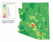
A population density map of Arizona
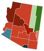 Map of counties in Arizona by racial plurality, per the 2020 U.S. censusLegend
- Non-Hispanic White 40–50%50–60%60–70%70–80%Native American40–50%70–80%Hispanic or Latino60–70%80–90%
- Non-Hispanic White
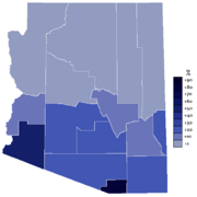
Extent of the Spanish language in the state of Arizona


| التعداد التاريخي | |||
|---|---|---|---|
| التعداد | Pop. | %± | |
| 1860 | 6٬482 | — | |
| 1870 | 9٬658 | 49�0% | |
| 1880 | 40٬440 | 318٫7% | |
| 1890 | 88٬243 | 118٫2% | |
| 1900 | 122٬931 | 39٫3% | |
| 1910 | 204٬354 | 66٫2% | |
| 1920 | 334٬162 | 63٫5% | |
| 1930 | 435٬573 | 30٫3% | |
| 1940 | 499٬261 | 14٫6% | |
| 1950 | 749٬587 | 50٫1% | |
| 1960 | 1٬302٬161 | 73٫7% | |
| 1970 | 1٬770٬900 | 36�0% | |
| 1980 | 2٬718٬215 | 53٫5% | |
| 1990 | 3٬665٬228 | 34٫8% | |
| 2000 | 5٬130٬632 | 40�0% | |
| 2010 | 6٬392٬017 | 24٫6% | |
| 2020 | 7٬151٬502 | 11٫9% | |
| 2022 (تق.) | 7٬359٬197 | 2٫9% | |
| Sources: 1910–2020[69] Note that early censuses may not include Native Americans in Arizona 2022[70] | |||
The United States Census Bureau records Arizona's population as 7,151,502 in the 2020 census,[4] a 12% increase since the 2010 United States census.[69]
Arizona remained sparsely settled for most of the 19th century.[71] The 1860 census reported the population of "Arizona County" to be 6,482, of whom 4,040 were listed as "Indians", 21 as "free colored", and 2,421 as "white".[72][73] Arizona's continued population growth puts an enormous stress on the state's water supply.[74] اعتبارا من 2011[تحديث], 61% of Arizona's children under age one belonged to racial groups of color.[75]
The population of metropolitan Phoenix increased by 45% from 1991 through 2001, helping to make Arizona the second fastest-growing state in the U.S. in the 1990s (the fastest was Nevada).[76] اعتبارا من يوليو 2018[تحديث], the population of the Phoenix area is estimated to be over 4.9 million.
According to the 2010 United States census, Arizona had a population of 6,392,017. In 2010, illegal immigrants constituted an estimated 8% of the population. This was the second highest percentage of any state in the U.S.[77][ب]
Metropolitan Phoenix (4.7 million) and Tucson (1.0 million) are home to about five-sixths of Arizona's people (as of the 2010 census). Metro Phoenix alone accounts for two-thirds of the state's population.
According to HUD's 2022 Annual Homeless Assessment Report, there were an estimated 13,553 homeless people in Arizona.[78][79]
In 2018, The top countries of origin for Arizona's immigrants were Mexico, Canada, India, the Philippines and China.[80]
Race and ethnicity
| Race and ethnicity[81] | Alone | Total | ||
|---|---|---|---|---|
| White (non-Hispanic) | 53.4% | 56.8% | ||
| Hispanic or Latino[ت] | — | 30.7% | ||
| African American (non-Hispanic) | 4.4% | 5.5% | ||
| Native American (non-Hispanic) | 3.7% | 4.9% | ||
| Asian | 3.5% | 4.5% | ||
| Pacific Islander | 0.2% | 0.4% | ||
| Other | 0.4% | 1.2% | ||
| Racial composition | 1970[82] | 1990[82] | 2000[83] | 2010[84] |
|---|---|---|---|---|
| White (non-Hispanic) | 74.3% | 71.7% | 63.8% | 57.8% |
| Native (non-Hispanic) | 5.4% | 5.6% | 5.0% | 4.6% |
| Black (non-Hispanic) | - | - | - | 4.1% |
| Asian | - | - | - | 2.8% |
| Native Hawaiian and other Pacific Islander |
- | – | – | 0.2% |
| Other race | - | - | - | 11.6% |
| Two or more races | – | – | - | 3.4% |
Arizona's five largest ancestry groups, اعتبارا من 2019[تحديث], were:[85]
Languages
| Language | Percentage of population (as of 2010)[86] |
|---|---|
| Spanish | 21% |
| Navajo | 2% |
| German | <1% |
| Chinese (including Mandarin) | <1% |
| Tagalog | <1% |
| Vietnamese | <1% |
| Other North American indigenous languages (especially indigenous languages of Arizona) | <1% |
| French | <1% |
| Arabic | <1% |
| Apache | <1% |
| Korean | <1% |

اعتبارا من 2010[تحديث], 73% (4,215,749) of Arizona residents age five and older spoke only English at home, while 21% (1,202,638) spoke Spanish, 2% (85,602) Navajo, <1% (22,592) German, <1% (22,426) Chinese (which includes Mandarin), <1% (19,015) Tagalog, <1% (17,603) Vietnamese, <1% (15,707) Other North American Indigenous Languages (especially indigenous languages of Arizona), and French was spoken as a main language by <1% (15,062) of the population over the age of five. In total, 27% (1,567,548) of Arizona's population age five and older spoke a mother language other than English.[86]
Arizona is home to the largest number of speakers of Native American languages in the 48 contiguous states, as more than 85,000 individuals reported speaking Navajo,[7] and 10,403 people reported Apache, as a language spoken at home in 2005.[7] Arizona's Apache County has the highest concentration of speakers of Native American Indian languages in the United States.[87]
Religion

Religious self-identification, per Public Religion Research Institute's 2022 American Values Survey[88]
The 2010 U.S. Religion Census: Religious Congregations & Membership Study by ARDA reported that the three largest denominational groups in Arizona were the Catholic Church, the Church of Jesus Christ of Latter-Day Saints and non-denominational Evangelical Protestants. The Catholic Church had the highest number of adherents in Arizona (at 930,001), followed by the Church of Jesus Christ of Latter-day Saints with 392,918 members reported and then non-denominational Evangelical Protestant churches, reporting 281,105 adherents. The religious body with the largest number of congregations is The Church of Jesus Christ of Latter-day Saints (with 811 congregations) followed by the Southern Baptist Convention (with 323 congregations).[89] This census accounted for about 2.4 million of Arizona's 6.4 million residents in 2010.
According to the study, the fifteen largest denominations by number of adherents in 2010 and 2000 were:[90][91]
| Religion | 2010 population | 2000 population |
|---|---|---|
| Unclaimed[92][93] | 4,012,089 | |
| Catholic Church | 930,001 | 974,884 |
| The Church of Jesus Christ of Latter-day Saints | 410,263 | 251,974 |
| Non-denominational Christianity | 281,105 | 63,885[ث] |
| Southern Baptist Convention | 126,830 | 138,516 |
| Assemblies of God | 123,713 | 82,802 |
| United Methodist Church | 54,977 | 53,232 |
| Christian Churches and Churches of Christ | 48,386 | 33,162 |
| Evangelical Lutheran Church in America | 42,944 | 69,393 |
| Lutheran Church–Missouri Synod | 26,322 | 24,977 |
| Presbyterian Church (U.S.A.) | 26,078 | 33,554 |
| Episcopal Church (United States) | 24,853 | 31,104 |
| Seventh-day Adventist Church | 20,924 | 11,513 |
| Church of the Nazarene | 16,991 | 18,143 |
| Lutheran Congregations in Mission for Christ | 14,350 | 0 |
| Churches of Christ | 14,151 | 14,471 |
Hinduism became the largest non-Christian religion (when combining all denominations) in 2010 with more than 32,000 adherents, followed by Judaism with more than 20,000 and Buddhism with more than 19,000.[90][94][95]
By the publication of the Public Religion Research Institute's 2020 study, 68% of the population identified as Christian.[96] At the Pew Research Center's 2014 study, 67% of Arizona was Christian.[97] Among the irreligious population from 2014 to 2020 per both studies, they have decreased from 27% of the population to 24% of self-identified irreligious or agnostic Arizonans. Additionally, a third separate study by the Association of Religion Data Archives in 2020 determined Christianity as the dominant religion in the state, with Catholics numbering 1,522,410 adherents and non-denominational Christians increasing to 402,842 Arizonan Christians.[98]
الإقتصاد

The 2020 total gross state product was $373 billion. The composition of the state's economy is moderately diverse, although health care, transportation and the government remain the largest sectors.[99]
The state's per capita income is $40,828, ranking 39th in the U.S. The state had a median household income of $50,448, making it 22nd in the country and just below the U.S. national mean.[100] Early in its history, Arizona's economy relied on the "five C's": copper (see Copper mining in Arizona), cotton, cattle, citrus, and climate (tourism). Copper is still extensively mined from many expansive open-pit and underground mines, accounting for two-thirds of the nation's output.
العمالة
- Total employment (2016): 2,379,409
- Total employer establishments (2016): 139,134[101]
The state government is Arizona's largest employer, while Banner Health is the state's largest private employer, with more than 39,000 employees (2016). اعتبارا من August 2020[تحديث], the state's unemployment rate was 5.9%.[102]
The largest employment sectors in Arizona are (August 2020, Nonfarm Employment):[102]
| القطاع | الموظفون |
|---|---|
| Trade, transportation, and utilities | 553,300 |
| Education and health services | 459,400 |
| Government | 430,400 |
| Professional and business services | 419,200 |
| Leisure and hospitality | 269,400 |
| Financial activities | 231,900 |
| Manufacturing | 170,900 |
| Construction | 169,900 |
| Other services | 95,600 |
| Information | 46,100 |
| Mining and logging | 13,300 |


أكبر أرباب العمل
According to The Arizona Republic, the largest private employers in the state اعتبارا من 2019[تحديث] were:[103]
الزراعة
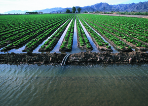
Multiple crops are grown in Arizona, including lettuce, spinach, cantaloupe, broccoli, cauliflower, cabbage, and watermelon.[104]
Federal crop insurance is available for grape (Vitis vinifera and other Vitis spp.) here.[105] Together with California's crop it falls under special provisions of the relevant crop insurance statutes.[105] Insect pests and diseases are covered, excluding Phylloxera (Daktulosphaira vitifoliae) or failure to correctly apply insect control or apply disease control.[105]
The whitefly Bemisia tabaci B was introduced through the poinsettia trade in the 1980s, displacing the previous A biotype.[106] In 2004 the Q biotype (from the Mediterranean) was first found here, also on poinsettia.[106]
The Colorado Potato Beetle (Leptinotarsa decemlineata) is either native or an early introduction here.[107] Unusually, the population here commonly feeds on Silverleaf Nightshade (Solanum elaeagnifolium), which is usually a less attractive host for this beetle.[107] The CPB is an occasional pest of tomato.[107]
النقل

الطرق السريعة
الطرق السريحة داخل الولاية
![]() Interstate 8 |
Interstate 8 | ![]() Interstate 10 |
Interstate 10 | ![]() Interstate 15 |
Interstate 15 | ![]() Interstate 17 |
Interstate 17 | ![]() Interstate 19 |
Interstate 19 | ![]() Interstate 40
Interstate 40
طرق الولايات المتحدة
![]() U.S. Route 60 |
U.S. Route 60 | ![]() U.S. Route 64 |
U.S. Route 64 | ![]() U.S. Route 70 |
U.S. Route 70 | ![]() U.S. Route 89 |
U.S. Route 89 | ![]() U.S. Route 66
U.S. Route 66
![]() U.S. Route 91 |
U.S. Route 91 | ![]() U.S. Route 93 |
U.S. Route 93 | ![]() U.S. Route 95 |
U.S. Route 95 | ![]() U.S. Route 160 |
U.S. Route 160 | ![]() U.S. Route 163
U.S. Route 163
![]() U.S. Route 180 |
U.S. Route 180 | ![]() U.S. Route 191 |
U.S. Route 191 | ![]() U.S. Route 466 |
U.S. Route 466 | ![]() U.S. Route 491
U.S. Route 491
الطيران
القانون والحكومة


المقاطعات
| مقاطعات أريزونا | ||||||
|---|---|---|---|---|---|---|
| اسم المقاطعة | مجلس المقاطعة | سنة التأسيس | السكان 2000 | النسبة من الإجمالي | المساحة (م3) | النسبة من الإجمالي |
| Apache | St. Johns | 1879 | 69,423 | 1.17 % | 11,218 | 9.84 % |
| Cochise | Bisbee | 1881 | 117,755 | 1.98 % | 6,219 | 5.46 % |
| Coconino | Flagstaff | 1891 | 116,320 | 1.96 % | 18,661 | 16.37 % |
| Gila | Globe | 1881 | 51,335 | 0.86 % | 4,796 | 4.21 % |
| Graham | Safford | 1881 | 33,489 | 0.56 % | 4,641 | 4.07 % |
| Greenlee | Clifton | 1909 | 8,547 | 0.14 % | 1,848 | 1.62 % |
| La Paz | Parker | 1983 | 19,715 | 0.33 % | 4,513 | 3.96 % |
| Maricopa | Phoenix | 1871 | 3,880,181 | 65.34 % | 9,224 | 8.09 % |
| Mohave | Kingman | 1864 | 155,032 | 2.61 % | 13,470 | 11.82 % |
| Navajo | Holbrook | 1895 | 97,470 | 1.64 % | 9,959 | 8.74 % |
| Pima | Tucson | 1864 | 843,746 | 14.21 % | 9,189 | 8.06 % |
| Pinal | Florence | 1875 | 179,727 | 3.03 % | 5,374 | 4.71 % |
| Santa Cruz | Nogales | 1899 | 36,381 | 0.65 % | 1,238 | 1.09 % |
| Yavapai | Prescott | 1865 | 167,517 | 2.82 % | 8,128 | 7.13 % |
| Yuma | Yuma | 1864 | 160,026 | 2.69 % | 5,519 | 4.84 % |
| Totals: 15 | 5,938,664 | 113,997 | ||||
الثقافة السياسية
| السنة | الحزب الجمهوري | الحزب الديموقراطي |
|---|---|---|
| 2008 | 53.60% 1,230,111 | 45.12% 1,034,707 |
| 2004 | 54.87% 1,104,294 | 44.40% 893,524 |
| 2000 | 50.95% 781,652 | 44.67% 685,341 |
| 1996 | 44.29% 622,073 | 46.52% 653,288 |
| 1992 | 38.47% 572,086 | 36.52% 543,050 |
| 1988 | 59.95% 702,541 | 38.74% 454,029 |
| 1984 | 66.42% 681,416 | 32.54% 333,854 |
| 1980 | 60.61% 529,688 | 28.24% 246,843 |
| 1976 | 56.37% 418,642 | 39.80% 295,602 |
| 1972 | 61.64% 402,812 | 30.38% 198,540 |
| 1968 | 54.78% 266,721 | 35.02% 170,514 |
| 1964 | 50.45% 242,535 | 49.45% 237,753 |
| 1960 | 55.52% 221,241 | 44.36% 176,781 |
انظر أيضا: الانتخابات الرئاسية الأمريكية 2004، في أريزونا
التعليم


رموز الولاية

انظر أيضا
المصادر
- ^ "State Area Measurements and Internal Point Coordinates".
- ^ "Frisco". NGS data sheet. U.S. National Geodetic Survey.
- ^ أ ب "Elevations and Distances in the United States". United States Geological Survey. 2001. Archived from the original on October 15, 2011. Retrieved December 28, 2011.
- ^ أ ب "Change in Resident Population of the 50 States, the District of Columbia, and Puerto Rico: 1910 to 2020" (PDF). Census.gov. United States Census Bureau. Archived (PDF) from the original on April 26, 2021. Retrieved April 27, 2020.
- ^ "US Census Bureau QuickFacts". Archived from the original on May 9, 2022. Retrieved April 30, 2022.
- ^ "Arizona—Definition and More from the Free Merriam-Webster Dictionary". Merriam-webster.com. April 25, 2007. Archived from the original on January 12, 2012. Retrieved December 28, 2011.
- ^ أ ب ت ث ج mla.org 2005 American Community Survey. Retrieved 2010-07-13. خطأ استشهاد: وسم
<ref>غير صالح؛ الاسم "mla2005" معرف أكثر من مرة بمحتويات مختلفة. - ^ "The 50 biggest companies in Arizona". AZBigMedia. Archived from the original on December 8, 2020. Retrieved 24 January 2021.
- ^ "All about Arizona". Sheppard Software. Archived from the original on November 20, 2017. Retrieved September 21, 2010.
- ^ "Federally Recognized Tribes in Arizona". Arizona State Museum. Archived from the original on September 26, 2021. Retrieved September 26, 2021.
- ^ Bright, William (2004). Native American Place Names of the United States. Norman, OK: University of Oklahoma Press. p. 47. ISBN 9780806135984.
- ^ Kitt, E.O.; Pearce, T.M. (1952). "Arizona Place Name Records". Western Folklore. 11 (4): 284–287. doi:10.2307/1496233. JSTOR 1496233.
- ^ Harper, Douglas. "Arizona". Online Etymology Dictionary. Archived from the original on July 28, 2011. Retrieved December 28, 2011.
- ^ McClintock, James (1916). Arizona, Prehistoric, Aboriginal, Pioneer, Modern: The Nation's Youngest Commonwealth within a Land of Ancient Culture. Chicago: The S.J. Clarke Publishing Co. Archived from the original on February 1, 2015. Retrieved November 9, 2019.
- ^ أ ب Thompson, Clay (February 25, 2007). "No, 'arid zone' not the basis of state's name". The Arizona Republic. Archived from the original on December 29, 2014. Retrieved March 14, 2023.
- ^ Saxton, Dean; Saxton, Lucille; Enos, Susie (1983). Dictionary: Tohono O'odham/Pima to English, English to Tohono O'odham/Pima. Tucson: University of Arizona Press. ISBN 9780816519422.
- ^ Thompson, Clay (February 25, 2007). "A sorry state of affairs when views change". The Arizona Republic. Archived from the original on June 4, 2012. Retrieved March 3, 2007.
- ^ Turner, Jim. "How Arizona Did NOT Get Its Name . . ". Arizona Historical Society. Archived from the original on October 13, 2007. Retrieved March 3, 2007.
- ^ Garate, Donald (2005). "Arizonac, a twentieth-century myth". Journal of Arizona History. 46 (2): 161–184. JSTOR 41696897.
- ^ "The Meaning of Arizona". Arizona Almanac. Arizona State Library Archives & Public Records. Archived from the original on July 16, 2019. Retrieved March 20, 2019.
- ^ Borrens, Lobby. "Francisco Vázquez de Coronado expedition to arizona". History. Archived from the original on December 7, 2021. Retrieved December 23, 2021.
- ^ Martínez Laínez, Fernando and Canales Torres, Carlos. Banderas lejanas: La exploración, conquista y defensa por parte de España del Territorio de los actuales Estados Unidos (in Spanish: Far flags. The exploration, conquest and defense by Spain of the Territory of the present United States). pp. 145–146. Fourth edition: September 2009.
- ^ "Father Kino converted many Indians to christans". nps. Archived from the original on October 19, 2021. Retrieved December 10, 2021.
- ^ Timothy Anna et al., Historia de México. Barcelona: Critica, 2001, p. 10.
- ^ "United States conqures arizona". history. Archived from the original on January 21, 2022. Retrieved December 10, 2021.
- ^ Mexican–American War as accessed on March 16, 2007, at 7:33 MST AM
- ^ "Gadsden purchase". historytoday. Archived from the original on December 28, 2021. Retrieved December 2, 2021.
- ^ "Arizona Ordinance of secession presented by the Col. Sherod Hunter Camp 1525, SCV, Phoenix, Arizona". Members.tripod.com. July 23, 2007. Archived from the original on October 2, 2006. Retrieved July 25, 2010.
- ^ United States. Cong. Senate (1904) [1st pub. Confederate States. Cong.: 1861–1862]. Journal of the Congress of the Confederate States of America, 1861–1865. Volume I. 58th Cong. 2d sess. S. Doc. 234. Washington: Government Printing Office. p. 691. LCCN 05012700. Archived from the original on February 22, 2019. Retrieved August 11, 2017 – via Internet Archive.
- ^ "Picacho Peak". American Battlefield Trust (in الإنجليزية الأمريكية). Retrieved 2023-08-10.
- ^ Bates, Al (April 14, 2019). "Arizona becomes a territory". AP News. Archived from the original on March 31, 2022. Retrieved December 10, 2021.
- ^ Henson, Pauline (1965). Founding a Wilderness Capital, Prescott, A. T., 1864. Flagstaff, AZ: Northland Press. pp. passim. LCCN 65-17578.
- ^ Arroyo Rodriguez, Nadine (September 26, 2014). "Did You Know: Capital Of Arizona Moved 4 Times Before Settling In Phoenix". kjzz. Archived from the original on January 14, 2019. Retrieved January 9, 2019.
- ^ "Preserving Cultural and Historic Resources – A Conservation Objective of the Sonoran Desert Conservation Plan". pima.gov. Archived from the original on July 3, 2010. Retrieved November 13, 2016.
- ^ Shillingberg, William (1999). Tombstone, A. T., A History of Early Mining, Milling and Mayhem. Spokane, WA: Arthur Clark. p. passim. ISBN 0870622730.
- ^ Bailey, Lynn (2002). Bisbee, Queen of the Copper Camps. Tucson: Westernlore Press. p. passim. ISBN 0870260588.
- ^ Clements, Eric (2003). After the Boom in Tombstone and Jerome, Arizona. Reno, NV: University of Nevada Press. p. passim. ISBN 0874175712.
- ^ Varney, Philip (1994). Arizona Ghost Towns and Mining Camps. Phoenix: Arizona Highways, DOT. p. passim. ISBN 0916179443.
- ^ Ascarza, William (2015). In Search of Fortunes, a Look at the History of Arizona Mining. Evansville, IN: M. T. Publishing. p. Passim. ISBN 978-1938730696.
- ^ Byrkit, James (1982). Forging the Copper Collar, Arizona's Labor-Management War, 1901–1921. Tucson: University of Arizona Press. p. passim. ISBN 08165-07457.
- ^ "Arizona becomes a state". worldhistoryproject. Archived from the original on December 31, 2021. Retrieved October 20, 2021.
- ^ tan, bri. "Arizona economy during great depression". Britannica. Archived from the original on August 31, 2021. Retrieved December 20, 2021.
- ^ "Biltomore hotel history". arizonabiltmore. Archived from the original on December 26, 2021. Retrieved December 10, 2021.
- ^ "Wigman resort history". wigmanresort. Archived from the original on November 4, 2021. Retrieved December 10, 2021.
- ^ Hobbs, Katie. "Arizona concentration camps". azliabary. Archived from the original on December 31, 2021. Retrieved December 20, 2021.
- ^ central, AZ. "Arizona concentration camps shut down". azcentral. Archived from the original on May 9, 2022. Retrieved December 20, 2021.
- ^ "Archaeology of the Phoenix Indian School". Archaeology.org. March 27, 1998. Archived from the original on November 3, 2009. Retrieved July 25, 2010.
- ^ "Arizona Democrats authorize Internet Voting for March 11 Advisory Primary" Archived نوفمبر 6, 2010 at the Wayback Machine, The Green Papers
- ^ "Supreme Court strikes down Arizona voting law". www.cbsnews.com. June 17, 2013. Archived from the original on August 11, 2020. Retrieved 7 February 2021.
- ^ ncsl, ncsl. "Arizona immigration law". ncsl. Archived from the original on January 20, 2022. Retrieved January 26, 2022.
- ^ Hulse, Carl; Zernike, Kate (January 9, 2011). "Bloodshed Puts New Focus on Vitriol in Politics". The New York Times. Archived from the original on January 25, 2021. Retrieved February 7, 2021.
- ^ "National Park Service – Arizona". National Park Service. Archived from the original on February 15, 2021. Retrieved January 10, 2021.
- ^ "Urban and Community Forestry Division". Arizona State Forestry Division. Archived from the original on July 14, 2014. Retrieved July 6, 2014.
- ^ "The World Factbook". Cia.gov. Archived from the original on April 30, 2020. Retrieved 2020-04-18.
- ^ "Prescott Overview". Ncsu.edu. May 15, 2002. Archived from the original on January 18, 2010. Retrieved July 25, 2010.
- ^ "Meteor Crater Arizona - World's Best Meteorite Impact Crater". www.meteorite.com. Archived from the original on September 13, 2022. Retrieved 2022-09-13.
- ^ أ ب "Arizona Climate". Desert Research Institute, Western Regional Climate Center, Reno, Nevada. December 7, 2001. Archived from the original on December 22, 2011. Retrieved December 28, 2011.
- ^ beat, your. "Climate records az". nyourcitybeat. Archived from the original on December 28, 2021. Retrieved December 2, 2021.
- ^ Climate Assessment for the Southwest (December 1999). "The Climate of the Southwest". University of Arizona. Archived from the original on October 12, 2007. Retrieved March 21, 2006.
- ^ United States Geological Survey (September 2005). "Hydrologic Conditions in Arizona During 1999–2004: A Historical Perspective" (PDF). Archived (PDF) from the original on November 4, 2011. Retrieved December 28, 2011.
- ^ "History for Phoenix, AZ". Weather Underground. August 31, 2006. Archived from the original on August 7, 2013. Retrieved December 28, 2011.
- ^ Hedding. "The Weather and Climate in Arizona: Too Hot to Handle?". TripSavvy. Archived from the original on September 14, 2022. Retrieved September 14, 2022.
- ^ "Mean number of Days with Minimum Temperature Below 32F National Oceanic and Atmospheric Administration, Retrieved March 24, 2007". Lwf.ncdc.noaa.gov. August 20, 2008. Archived from the original on December 17, 2001. Retrieved December 28, 2011.
- ^ "Arizona climate averages". Weatherbase. Archived from the original on October 9, 2015. Retrieved November 11, 2015.
- ^ "Phoenix Business Journal". September 2, 2011. p. 4.
- ^ "Welcome to Lake Havasu City". Lake Havasu City. Archived from the original on August 23, 2015. Retrieved July 5, 2015.
- ^ "ASU@Lake Havasu". Arizona Board of Regents. Archived from the original on March 20, 2019. Retrieved March 20, 2019.
- ^ "City and Town Population Totals: 2020-2021". United States Census Bureau. Archived from the original on July 11, 2022. Retrieved September 6, 2022.
- ^ أ ب Bureau, US Census. "Historical Population Change Data (1910–2020)". Census.gov. Archived from the original on April 29, 2021.
- ^ "Growth in U.S. Population Shows Early Indication of Recovery Amid COVID-19 Pandemic". Census Bureau QuickFacts. 2022-12-22. Archived from the original on April 19, 2023. Retrieved 2023-04-20.
- ^ Arizona (state, United States) Archived فبراير 26, 2010 at the Wayback Machine. Encyclopædia Britannica Online.
- ^ "Arizona – Race and Hispanic Origin: 1860 to 1990." (PDF). U.S. Census Bureau. Archived فبراير 9, 2018 at the Wayback Machine.
- ^ Census.gov Arizona – Race and Hispanic Origin: 1860 to 1990 Archived يناير 12, 2012 at the Wayback Machine
- ^ "Arizona at a crossroads over water and growth". The Arizona Republic. March 9, 2008.
- ^ "Americans under age one now mostly minorities, but not in Ohio: Statistical Snapshot Archived يوليو 14, 2016 at the Wayback Machine". The Plain Dealer. June 3, 2012.
- ^ "Ranking Tables for Metropolitan Areas: 1990 and 2000 Archived يوليو 19, 2018 at the Wayback Machine." United States Census Bureau. April 2, 2001. Retrieved on July 8, 2006.
- ^ Slevin, Peter (April 30, 2010). "New Arizona law puts police in 'tenuous' spot". Washington Post. Washington, DC. p. A4. Archived from the original on January 31, 2011. Retrieved December 28, 2011.
- ^ "2007-2022 PIT Counts by State". Archived from the original on March 14, 2023. Retrieved March 11, 2023.
- ^ "The 2022 Annual Homelessness Assessment Report (AHAR) to Congress" (PDF). Archived (PDF) from the original on March 11, 2023. Retrieved March 11, 2023.
- ^ "Immigrants in Arizona" (PDF).
- ^ "Race and Ethnicity in the United States: 2010 Census and 2020 Census". census.gov. United States Census Bureau. August 12, 2021. Archived from the original on August 15, 2021. Retrieved 2021-09-26.
- ^ أ ب Historical Census Statistics on Population Totals By Race, 1790 to 1990, and By Hispanic Origin, 1970 to 1990, For The United States, Regions, Divisions, and States Archived ديسمبر 24, 2014 at the Wayback Machine
"Table 17. Arizona – Race and Hispanic Origin: 1860 to 1990 Archived مايو 14, 2015 at the Wayback Machine". (PDF) - ^ "Population of Arizona – Census 2010 and 2000 Interactive Map, Demographics, Statistics, Quick Facts – CensusViewer". censusviewer.com. Archived from the original on January 26, 2017. Retrieved January 6, 2014.
- ^ "2010 Census Data". Archived from the original on May 22, 2017. Retrieved February 18, 2018.
- ^ Cenuseas ancetry, United states of america. "Arizonas demographics that equal 100 but most of it is under 3. also updated!". namecensus. Archived from the original on December 28, 2021. Retrieved December 2, 2021.
- ^ أ ب "Arizona". Modern Language Association. Archived from the original on December 1, 2007. Retrieved October 15, 2013.
- ^ Arizona has most Indian language speakers Archived ديسمبر 12, 2011 at the Wayback Machine. upi.com Accessed December 12, 2011.
- ^ Staff (February 24, 2023). "American Values Atlas: Religious Tradition in Arizona". Public Religion Research Institute. Archived from the original on April 4, 2017. Retrieved 2023-04-14.
- ^ "The Association of Religion Data Archives | State membership Report". www.Thearda.com. Archived from the original on December 7, 2014. Retrieved November 7, 2013. For 2010, it uses data in the 2010 U.S. Religion Census: Religious Congregations & Membership Study produced by the Association of Statisticians of American Religious Bodies (ASARB) which depends on reporting by the religious bodies.
- ^ أ ب "Arizona – Religious Traditions, 2010". Association of Religion Data Archives. Archived from the original on August 2, 2017. Retrieved August 2, 2017.
- ^ "Arizona – Religious Traditions, 2010". Association of Religion Data Archives. Archived from the original on August 2, 2017. Retrieved August 2, 2017.
- ^ "The Association of Religion Data Archives | Maps & Reports". Archived from the original on August 10, 2022. Retrieved August 10, 2022.
- ^ "The Association of Religion Data Archives | Maps and Reports | Reports | Denomination Listing: Unclaimed". Archived from the original on August 10, 2022. Retrieved August 10, 2022.
- ^ "How Hindus Grew into Second-Largest Faith in Arizona & Delaware". NBC News. June 24, 2014. Archived from the original on August 2, 2017. Retrieved August 2, 2017.
- ^ "U.S. Religion Census 2010: Summary Findings" (PDF). Association of Statisticians of American Religious Bodies. May 1, 2012. p. 16. Archived from the original (PDF) on February 1, 2017. Retrieved August 2, 2017.
- ^ "PRRI – American Values Atlas". ava.prri.org. Archived from the original on April 4, 2017. Retrieved September 17, 2022.
- ^ "Religious Landscape Study". Pew Research Center's Religion & Public Life Project (in الإنجليزية الأمريكية). Archived from the original on April 1, 2022. Retrieved September 17, 2022.
- ^ "Maps and data files for 2020 | U.S. Religion Census | Religious Statistics & Demographics". www.usreligioncensus.org. Archived from the original on January 15, 2023. Retrieved 2023-01-17.
- ^ Research, Economy (January 1997). "Arizona gross production". stlouisfed. Archived from the original on December 16, 2021. Retrieved December 2, 2021.
- ^ "News Release" (PDF). Archived from the original (PDF) on September 21, 2012. Retrieved December 28, 2011.
- ^ "QuickFacts Arizona". Archived from the original on November 9, 2019. Retrieved November 11, 2019.
- ^ أ ب "Arizona Economy at a Glance". Bls.gov. Archived from the original on October 24, 2020. Retrieved October 28, 2020.
- ^ "Arizona Republic 100: State's biggest employers"[dead link]. The Arizona Republic.
- ^ "USDA/NASS 2021 State Agriculture Overview for Arizona". USDA, National Agricultural Statistics Service. Archived from the original on July 5, 2022. Retrieved 2022-06-29.
- ^ أ ب ت "7 CFR § 457.138 - Grape crop insurance provisions". Legal Information Institute (LII). July 25, 2016. Archived from the original on October 5, 2022. Retrieved June 28, 2022.
- ^ أ ب قالب:Unbulleted list citebundle
- ^ أ ب ت قالب:Unbulleted list citebundle
ملاحظات
قراءات إضافية
- Bayless, Betsy, 1998, Arizona Blue Book, 1997-1998. Phoenix, Arizona.
- McIntyre, Allan J., 2008, The Tohono O'odham and Pimeria Alta. Arcadia Publishing, Charleston, South Carolina. (ISBN 978-0738556338).
- Miller, Tom (editor), 1986, Arizona: The Land and the People. University of Arizona Press, Tucson. (ISBN 0-8165-1004-0).
- Officer, James E., 1987, Hispanic Arizona, 1536-1856. University of Arizona Press, Tucson. (ISBN 0-8165-0981-6).
- Thomas, David M. (editor), 2003, Arizona Legislative Manual. In Arizona Phoenix, Arizona, Arizona Legislative Council. Google Print. Retrieved January 16, 2006.
- Trimble, Marshall, 1998, Arizona, A Cavalcade of History. Treasure Chest Publications, Tucson, Arizona. (ISBN 0-918080-43-6).
- Woosley, Anne I., 2008, Early Tucson. Arcadia Publishing, Charleston, South Carolina. (ISBN 0738556467).
وصلات خارجية
![]() تعريفات قاموسية في ويكاموس
تعريفات قاموسية في ويكاموس
![]() كتب من معرفة الكتب
كتب من معرفة الكتب
![]() اقتباسات من معرفة الاقتباس
اقتباسات من معرفة الاقتباس
![]() نصوص مصدرية من معرفة المصادر
نصوص مصدرية من معرفة المصادر
![]() صور و ملفات صوتية من كومونز
صور و ملفات صوتية من كومونز
![]() أخبار من معرفة الأخبار.
أخبار من معرفة الأخبار.
الموقع الرسمي لحكومة الولاية
مصادر أخرى
- Arizona State Guide, from the Library of Congress
- Arizona Regional Accounts Data
- Arizona Demographic Data from FedStats
- Community profiles from Arizona Department of Commerce
- Arizona Indicators, state's central resource for information on a wide range of topics
- Energy Data & Statistics for Arizona
- Arizona State Databases – Annotated list of searchable databases produced by Arizona state agencies and compiled by the Government Documents Roundtable of the American Library Association.
- Arizona State Library, Archives and Public Records
- USGS real-time, geographic, and other scientific resources of Arizona
- Arizona State Facts
- Morrison Institute for Public Policy, independent research and analysis center for Arizona public policy and issues
- Arizona Republic -- daily newspaper serving the state
- أريزونا at the Open Directory Project
معلومات سياحية
- Official Arizona Office of Tourism
- Arizona Game & Fish Department (Hunting, Boating & Fishing)
- Arizona State Parks
- American Southwest, a National Park Service Discover Our Shared Heritage Travel Itinerary

|
كلورادو | يوتا | نڤادا |
|
| نيو مكسيكو | كاليفورنيا | |||
قالب:AZ cities and mayors of 100,000 population
Coordinates: 34°N 112°W / 34°N 112°W
خطأ استشهاد: وسوم <ref> موجودة لمجموعة اسمها "lower-alpha"، ولكن لم يتم العثور على وسم <references group="lower-alpha"/>
- CS1 الإنجليزية الأمريكية-language sources (en-us)
- Articles with dead external links from July 2022
- Short description is different from Wikidata
- Pages using infobox settlement with possible nickname list
- صفحات تستخدم قالب:تاريخ إطلاق وعمر مع وسائط غير معروفة
- Pages using infobox settlement with no coordinates
- Articles containing إسپانية-language text
- Articles containing O'odham-language text
- Articles containing باسكية-language text
- Articles with unsourced statements from June 2023
- Articles with hatnote templates targeting a nonexistent page
- مقالات فيها عبارات متقادمة منذ 2011
- جميع المقالات التي فيها عبارات متقادمة
- مقالات فيها عبارات متقادمة منذ يوليو 2018
- مقالات فيها عبارات متقادمة منذ 2019
- مقالات فيها عبارات متقادمة منذ 2010
- مقالات فيها عبارات متقادمة منذ August 2020
- Coordinates on Wikidata
- ولايات ومناطق تأسست في 1912
- أريزونا
- مستعمرات إسپانية سابقة
- الشاطئ الغربي الأمريكي
- ولايات الولايات المتحدة الأمريكية