أور
| هذه المقالة تحتوي على حروف خاصة. بدون دعم العرض المناصب، فقد ترى علامات استفهام، مربعات، أو رموز أخرى. |
 | |
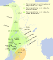
 Ur كما يظهر في العراق  Ur Ur (الشرق الأدنى)  Ur Ur (West and Central Asia) | |
| المكان | تل المقير، محافظة ذي قار، العراق |
|---|---|
| المنطقة | بلاد الرافدين، الشرق الأوسط |
| الإحداثيات | 30°57′42″N 46°06′18″E / 30.9616529°N 46.1051259°ECoordinates: 30°57′42″N 46°06′18″E / 30.9616529°N 46.1051259°E |
| النوع | مستوطنة |
| التاريخ | |
| تأسس | ح. 3800 ق.م. |
| هـُـجـِر | بعد 500 ق.م. |
| الفترات | فترة العبيد حتى العصر الحديدي |
| الثقافات | السومرية |
| ملاحظات حول الموقع | |
| تواريخ الحفريات | 1853–1854, 1922–1934 |
| الأثريون | John George Taylor, Charles Leonard Woolley |
| موقع تراث عالمي لليونسكو | |
| Official name | مدينة أور الأثرية Ur Archaeological City |
| جزء من | الأهوار |
| السمات | Mixed: (iii)(v)(ix)(x) |
| مراجع | 1481-006 |
| التدوين | 2016 (40 Session) |
| المساحة | 71 ha (0.27 sq mi) |
| منطقة عازلة | 317 ha (1.22 sq mi) |
أور ( Ur ؛ /ʊər/؛ بالسومرية: 𒌶𒆠, 𒋀𒀕𒆠, or 𒋀𒀊𒆠[note 1] Urim;[1] آكادية: 𒋀𒀕𒆠 Uru;[2] بالعبرية: אוּר)، هو مدينة-دولة سومرية في بلاد الرافدين القديمة، وتقع في موقع يُدعى حالياً تل المُقيَّر في محافظة ذي قار بجنوب العراق.[3] وبالرغم من أن أور كانت يوماً ما مدينة ساحلية بالقرب من مصب الفرات في الخليج العربي، إلى أن خط الساحل تراجع وأصبحت المدينة الآن داخل البر بنحو 160 كيلومتر شمال البصرة، على الضفة الجنوبية للفرات، على بعد 16 كم من الناصرية في العراق الحالي.[4] تعود المدينة إلى فترة العبيد حوالي 3800 ق.م.، ومسجلة في التاريخ المكتوب كمدينة-دولة من القرن 26 ق.م.، وأول ملوكها المسجلين هو Mesannepada.
وكانت بيضاوية الشكل.
The city's patron deity was Nanna (in Akkadian, Sin), the Sumerian and Akkadian moon god, and the name of the city is in origin derived from the god's name, UNUGKI, literally "the abode (UNUG) of Nanna".[4] The site is marked by the partially restored ruins of the Ziggurat of Ur, which contained the shrine of Nanna, excavated in the 1930s. The temple was built in the 21st century BC (short chronology), during the reign of Ur-Nammu and was reconstructed in the 6th century BC by Nabonidus, the last king of Babylon. The ruins cover an area of 1,200 metres (3,900 ft) northwest to southeast by 800 metres (2,600 ft) northeast to southwest and rise up to about 20 metres (66 ft) above the present plain level.[5]
. . . . . . . . . . . . . . . . . . . . . . . . . . . . . . . . . . . . . . . . . . . . . . . . . . . . . . . . . . . . . . . . . . . . . . . . . . . . . . . . . . . . . . . . . . . . . . . . . . . . . . . . . . . . . . . . . . . . . . . . . . . . . . . . . . . . . . . . . . . . . . . . . . . . . . . . . . . . . . . . . . . . . . . .
مخطط المدينة

The city, said to have been planned by Ur-Nammu, was apparently divided into neighbourhoods, with merchants living in one quarter, artisans in another. There were streets both wide and narrow, and open spaces for gatherings. Many structures for water resource management and flood control are in evidence. Houses were constructed from mudbricks and mud plaster. In major buildings, the masonry was strengthened with bitumen and reeds. For the most part, foundations are all that remain today. People were often buried (separately and alone; sometimes with jewellery, pots, and weapons) in chambers or shafts beneath the house floors.[6]

Ur was surrounded by sloping ramparts 8 metres (26 feet) high and about 25 metres (82 feet) wide, bordered in some places by a brick wall. Elsewhere, buildings were integrated into the ramparts. The Euphrates River complemented these fortifications on the city's western side.[6]
المجتمع والثقافة
Archaeological discoveries have shown unequivocally that Ur was a major Sumerian urban center on the Mesopotamian plain. Especially the discovery of the Royal Tombs has confirmed its splendour. These tombs, which date to the Early Dynastic IIIa period (approximately in the 25th or 24th century BC), contained an immense treasure of luxury items made of precious metals and semi-precious stones imported from long distances (Ancient Iran, Afghanistan, India, Asia Minor, the Levant and the Persian Gulf).[5] This wealth, unparalleled up to then, is a testimony of Ur's economic importance during the Early Bronze Age.[7]
Archaeological study of the region has contributed greatly to our understanding of the landscape and long-distance interactions during these ancient times. Ur was a major port on the Persian Gulf, which extended much farther inland than today, and the city controlled much of the trade into Mesopotamia. Imports to Ur came from many parts of the world: precious metals such as gold and silver, and semi-precious stones, namely lapis lazuli and carnelian.[6]
It is thought that Ur had a stratified social system including slaves (captured foreigners), farmers, artisans, doctors, scribes, and priests. High-ranking priests apparently enjoyed great luxury and splendid mansions. Tens of thousands of cuneiform texts have been recovered from temples, the palace, and individual houses, recording contracts, inventories, and court documents, evidence of the city's complex economic and legal systems.[6]
.jpg&filetimestamp=20230419043356&)

Excavation in the old city of Ur in 1929 revealed the Lyres of Ur, instruments similar to the modern harp but in the shape of a bull and with eleven strings.[8]


ولد بها الخليل إبراهيم أبو الأنبياء عام 2000 ق.م. ونزلت عليه فيها الرسالة الحنفية. واشتهرت المدينة بالزقورة التي هي معبد لنانا الهة القمر في الأساطير (الميثولوجيا) السومرية. وكان بها 16 مقبرة ملكية شيدت من الطوب اللبن. وكان بكل مقبرة بئر . وكان الملك الميت يدفن معه جواريه بملابسهن وحليهن بعد قتلهن بالسم عند موته. وكان للمقبرة قبة.
التاريخ

ما قبل التاريخ
أور كانت مسكونة منذ فترة العبيد حيث كانت القرى عبارة عن مستوطنات زراعية، ولكنها اصبحت مستوطنة كبيرة مع حاجة هذه المدن إلى مستوى أعلى من حيث السيطرة على الري في اوقات الجفاف. وفي الفترة 2600ق.م وخلال حكم السلالة الثالثة في الفترة المبكرة ازدهرت اور من جديد. وأصبحت المدينة المقدسة للالهة نانا. وفي الاخير أصبح ملوك أور هم الحكام المسيطرين على سومر
When Ur was founded, the Persian Gulf's water level was two-and-a-half metres higher than today. Ur is therefore thought to have had marshy surroundings; irrigation would have been unnecessary, and the city's evident canal system was likely used for transportation. Fish, birds, tubers, and reeds might have supported Ur economically without the need for an agricultural revolution sometimes hypothesized as a prerequisite to urbanization.[9][10]
Archaeologists have discovered the evidence of an early occupation at Ur during the Ubaid period (c. 6500 to 3800 BC). These early levels were sealed off with a sterile deposit of soil that was interpreted by excavators of the 1920s as evidence for the Great Flood of the Book of Genesis and Epic of Gilgamesh. It is now understood that the South Mesopotamian plain was exposed to regular floods from the Euphrates and the Tigris rivers, with heavy erosion from water and wind, which may have given rise to the Mesopotamian and derivative Biblical Great Flood stories.[11][12]
العصر البرونزي
There are various main sources informing scholars about the importance of Ur during the Early Bronze Age. Proto-cuneiform tablets from the Early Dynastic period, c. 2900 BC, have been recovered.[13][14] The First Dynasty of Ur seems to have had great wealth and power, as shown by the lavish remains of the Royal Cemetery at Ur. The Sumerian King List provides a tentative political history of ancient Sumer and mentions, among others, several rulers of Ur. Mesannepada is the first king mentioned in the Sumerian King List, and appears to have lived in the 26th century BC. That Ur was an important urban centre already then seems to be indicated by a type of cylinder seal called the City Seals. These seals contain a set of Proto-Cuneiform signs which appear to be writings or symbols of the name of city-states in ancient Mesopotamia. Many of these seals have been found in Ur, and the name of Ur is prominent on them.[15] Ur came under the control of the Semitic-speaking Akkadian Empire founded by Sargon the Great between the 24th and 22nd centuries BC. This was a period when the Semitic-speaking Akkadians, who had entered Mesopotamia in approximately 3000 BC, gained ascendancy over the Sumerians, and indeed much of the ancient Near East.
Empire of the Third Dynasty of Ur. West is at top, north at right.
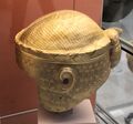
Gold helmet of King of Ur I Meskalamdug, c. 2600–2500 BC
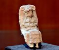
Mesopotamian female deity seated on a chair, Old-Babylonian fired clay plaque from Ur


أور III

After a short period of chaos following the fall of the Akkadian Empire the third Ur dynasty was established when the king Ur-Nammu came to power, ruling between c. 2047 BC and 2030 BC. During his rule, temples, including the Ziggurat of Ur, were built, and agriculture was improved through irrigation. His code of laws, the Code of Ur-Nammu (a fragment was identified in Istanbul in 1952) is one of the oldest such documents known, preceding the Code of Hammurabi by 300 years. He and his successor Shulgi were both deified during their reigns, and after his death he continued as a hero-figure: one of the surviving works of Sumerian literature describes the death of Ur-Nammu and his journey to the underworld.[16]
Ur-Nammu was succeeded by Shulgi, the greatest king of the Third Dynasty of Ur, who solidified the hegemony of Ur and reformed the empire into a highly centralized bureaucratic state. Shulgi ruled for a long time (at least 42 years) and deified himself halfway through his rule.[17]
The Ur empire continued through the reigns of three more kings with Semitic Akkadian names,[11] Amar-Sin, Shu-Sin, and Ibbi-Sin. It fell around 1940 BC to the Elamites in the 24th regnal year of Ibbi-Sin, an event commemorated by the Lament for Ur.[18][19]
According to one estimate, Ur was the largest city in the world from c. 2030 to 1980 BC. Its population was approximately 65,000 (or 0.1 per cent share of global population then).[بحاجة لمصدر]
The city of Ur lost its political power after the demise of the Third Dynasty of Ur. Nevertheless, its important position which kept on providing access to the Persian Gulf ensured the ongoing economic importance of the city during the second millennium BC. The city came to be ruled by the first dynasty (Amorite) of Babylon which rose to prominence in southern Mesopotamia in the 19th century BC. After the fall of Hammurabi's short lived Babylonian Empire, it later became a part of the Sealand Dynasty for several centuries. It then came under the control of the Kassites in the 16th century BC.[20]
. . . . . . . . . . . . . . . . . . . . . . . . . . . . . . . . . . . . . . . . . . . . . . . . . . . . . . . . . . . . . . . . . . . . . . . . . . . . . . . . . . . . . . . . . . . . . . . . . . . . . . . . . . . . . . . . . . . . . . . . . . . . . . . . . . . . . . . . . . . . . . . . . . . . . . . . . . . . . . . . . . . . . . . .
الألفية الثالثة قبل الميلاد


تأسست السلالة الملكية الأولى في أور في القرن السابع والعشرين قبل الميلاد تقريباً وكانت مركزاً سومرياً مهماً. وقد عُرف من القوائم الملكية ستة من ملوك هذه السلالة، وانتهت هذه السلالة على يد إيانا توم Eannatum أحد قادة مدينة لَغَش، وقد خلفت هذه الأسرة أهم المعالم التاريخية في هذه المدينة منها: الزقورة (برج هرمي لأغراض دينية)، والمدافن الملكية التي من أهمها مدفن الملكة (أو الكاهنة) «يو ـ أبي» التي كانت تُعرف في المراجع العلمية باسم شُبعاد، واحتوت هذه المدافن على لُقى بالغة الروعة والجمال ودقة الصنعة من الذهب واللازورد والفضة وغيرها مما كان يستعمله ملوك سلالة أور الأولى. ولما تمكن الأكديون من توحيد بلاد مابين النهرين بعد قتال شديد دخلت مدينة أور تحت سيطرتهم. وبعد زوال الامبراطورية الأكدية على يد الغوتيين خضعت أور للسلطة الجديدة. وفي ظل حكم هؤلاء الغوتيين قامت بعض المدن السومرية القديمة باستعادة قدر من الاستقلال وكانت أور من بين تلك المدن.
تمكن أوتو هيگال Utu-Hegal ملك أوروك (الوركاء) بعد مدَّة من الزمن من تحرير بلاده من الحكم الغوتي بمساعدة أورنامو الذي عُيّن حاكماً على أور، والذي مالبث أن أعلن استقلاله بعد سبع سنوات عن أوروك، وأقام نفسه ملكاً على أور وعلى بلاد سومر وأَكد مؤسساً بذلك مادُعي سلالة أور الثالثة (2050-1950ق.م)، وبذلك عادت أور لتتصدر الحياة السياسية والاقتصادية والثقافية والإدارية في بلاد مابين النهرين وماجاورها مدّة تزيد قليلاً على مئة عام.
تميز عهد سلالة أور الثالثة بإحياء الثقافة السومرية، إذ كُتبت معظم وثائقها بالسومرية إلا أنها لم تبطل الكتابة باللغة الأكدية، كما أنها قبلت على العموم أفكار سرگون الأكدي السياسية، وأخذت بالفكرة القائلة: «إن الملكية هبطت من السماء، وقد مُنِحتها في مدة محدودة مدنٌ أخرى ومالبثت أن عادت إلى أور». ويبدو أن ذلك كان محاولة من أورنامو لإضفاء الشرعية على حكمه، وهكذا صار حكام المناطق الأخرى أتباعاً لملك أور. أما الفن في هذه الحقبة فكان أقرب إلى فن لَغَش أكثر منه إلى الفن الأكدي، إذ لوحظت اختلافات كبيرة في تصميم الأختام، وتلاشت التنوعات التي كانت سائدة في العصر الأكدي، وحل محلها موضوع واحد هو ما عُرف بمشهد التقدمات التي تُظهر الملك أمام الرب. أو يُظهر أحد الرسميين أمام الملك، ومثل هذه الموضوعات كانت نادرة في العهود الأكدية، ولكنها كانت شائعة في لَغَش في عهد غوديا على حد قول العالم الأثري هنري فرانكفورت H.Frankfort. ومن أهم الأعمال الفنية المتبقية مسلة أورنامو التي ما يزال هناك بعض أجزائها، فقد كان ارتفاعها في الأصل ثلاثة أمتار وعرضها متر ونصف المتر، مُثل عليها مشهد يظهر الملك في الأعلى يقدم قرباناً أمام أحد الأرباب، وفوقه ربة تحمل إناء ينساب منه الماء القادم من السماء، وفي «الحقل» الذي يليه يتكرر المشهد نفسه ويشاهد الملك متجهاً مرة إلى اليمين ومرة نحو اليسار، وقد يمثل هذا النُّصب طقوس العبادة التي كان أورنامو يقوم بها للرب نانار Nannar وشريكته ننگال Ningal.

ومن أهم ما خلفه هذا العاهل من نصوص قانون أورنامو هو «السجل العقاري»، ويبدو أن الباقي من القانون والسجل ماهو إلا نسختان عن الأصل السومري المفقود. وقام أورنامو بحفر القنوات والمنشآت المائية وتوسيع القائم منها، كما أعاد بناء الزقورة المعروفة، وأضاف إليها إضافات كبيرة.[21]
العصر البرونزي والحديدي

خلف أورنامو ولدُه شولگي Shulgi الذي حكم مدة طويلة وصلت إلى نحو تسعة وأربعين عاماً سعى فيها إلى إظهار سلطته على بلاد بابل كلها، وأطلق على نفسه إضافة إلى ألقاب سلفه «ملك الجهات الأربع» وألَّه نفسه مما لم يفعله أي ملك سابق، وكان كوالده محباً للثقافة السومرية، فسعى إلى إحياء كل ماهو سومري واهتم بمدينة إريدو المركز الديني المهم، ولكنه كما يذكر هال H.R.Hall اتبع نصائح الشيطان فأخذ كنوز أي ـ ساگيل E-sagil وبابل غنائم.
خلف شولگي، أمار ـ سين Amar-Sin الذي تتحدث حوليات حكمه عن حملات عسكرية، وعن ترسيم حدود مملكة أور الثالثة، إضافة إلى تعيين كبار الكهنة في أور وأوروك وإريدو. وجاء بعده شو ـ سين Shu-sin فقام بحملات عسكرية وألّه نفسه، وحصّن البلاد في وجه أخطار الهجرات الأمورية (العمورية)، ثم جاء إبي ـ سين (2028- 2004ق.م) Ibi-Sin الذي جابه كسلفه أخطار الهجرات الأمورية القادمة من الغرب، أي من منطقة الفرات الأوسط، وأخطار التهديد العيلامي القادم من الشرق. إلا أن هذه الأعمال لم تستطع المحافظة على وحدة الامبراطورية. ومما زاد الأمر تعقيداً مرور البلاد بسنوات عجاف كثيرة ساد فيها الجوع والفوضى، وتمرد أحد قادة إبي سين واسمه إشبي إرّا Ishbi-Erra مما سبب انفصال المدن التابعة لمملكة أور الواحدة تلو الأخرى، ومن ثَمَّ تراجعت حدود المملكة لتقتصر على أور وماجاورها.
ثم كانت نهاية أور المفجعة على يد عيلام، فدُمرت المدينة وحُملَ إبي سين الخلف الثالث لشولغي أسيراً إلى عيلام. ويذكر نص متأخر يعود للملك آشور بانيبال الآشوري أن العيلاميين أسقطوا أور وأخذوا ربتها نانا Nana إلى سوسة وظلت هناك إلى نحو عام 647ق.م حين استولى آشور بانيبال عليها، وأعاد نانا في موكب نصر إلى مدينتها أور مركزها الأصلي.
ومع أن أور فقدت أهميتها السياسية بزوال سلالتها الثالثة فإنها ظلت موضع احترام كبير من الملوك لأهميتها الدينية، ففي ظل الحكم الكاشي لبابل حاول أحد ملوكها واسمه كوري غلزو Kurigalzo ترميم معابدها التي كانت قد هجرت جزئياً، وقام نبوخذ نصَّر الثاني في القرن السادس قبل الميلاد بترميم المنطقة المقدسة في أور ببواباتها الست، كما أعاد بناء الزقورة التي تعود بأصولها إلى سلالتها الأولى، ولكن كل هذه الأعمال لم تستطع إعادة الحياة إلى المدينة بعد أن ابتعد عنها الفرات شرقاً وتركها وحيدة في صحراء قاحلة، ففقدت تدريجياً ثراءها وحياتها، وهُجرت نهائياً نحو عام 400ق.م متحولة إلى تلال وسط الصحراء.
العلاقة بأور التوراتية

Ur is possibly the city of Ur Kasdim mentioned in the Book of Genesis as the birthplace of the Hebrew and Muslim patriarch Abraham (Ibrahim in Arabic), traditionally believed to have lived some time in the 2nd millennium BC.[22][23] There are however conflicting traditions and scholarly opinions identifying Ur Kasdim with the sites of Şanlıurfa, Urkesh, Urartu or Kutha.
The biblical Ur is mentioned four times in the Torah or Hebrew Bible, with the distinction "of the Kasdim/Kasdin"—traditionally rendered in English as "Ur of the Chaldees". The Chaldeans had settled in the vicinity by around 850 BC, but were not extant anywhere in Mesopotamia during the 2nd millennium BC period when Abraham is traditionally held to have lived. The Chaldean dynasty did not rule Babylonia (and thus become the rulers of Ur) until the late 7th century BC, and held power only until the mid 6th century BC. The name is found in Genesis 11:28, Genesis 11:31, and Genesis 15:7. In Nehemiah 9:7, a single passage mentioning Ur is a paraphrase of Genesis.
In March 2021, Pope Francis visited Ur during his journey through Iraq.[24]
. . . . . . . . . . . . . . . . . . . . . . . . . . . . . . . . . . . . . . . . . . . . . . . . . . . . . . . . . . . . . . . . . . . . . . . . . . . . . . . . . . . . . . . . . . . . . . . . . . . . . . . . . . . . . . . . . . . . . . . . . . . . . . . . . . . . . . . . . . . . . . . . . . . . . . . . . . . . . . . . . . . . . . . .
التنقيب عن الآثار
_but_2500_-_6000_y.o..JPG&filetimestamp=20230419045310&)
_(14767185992).jpg&filetimestamp=20230419045305&)
In 1625, the site was visited by Pietro Della Valle, who recorded the presence of ancient bricks stamped with strange symbols, cemented together with bitumen, as well as inscribed pieces of black marble that appeared to be seals. European archaeologists did not identify Tell el-Muqayyar as the site of Ur until Henry Rawlinson successfully deciphered some bricks from that location, brought to England by William Loftus in 1849.[25]
The site was first excavated in 1853 and 1854, on behalf of the British Museum and with instructions from the Foreign Office, by John George Taylor, British vice consul at Basra from 1851 to 1859.[26][27][28] Taylor uncovered the Ziggurat of Ur and a structure with an arch later identified as part of the "Gate of Judgment".[29]
In the four corners of the ziggurat's top stage, Taylor found clay cylinders bearing an inscription of Nabonidus (Nabuna`id), the last king of Babylon (539 BC), closing with a prayer for his son Belshar-uzur (Bel-ŝarra-Uzur), the Belshazzar of the Book of Daniel. Evidence was found of prior restorations of the ziggurat by Ishme-Dagan of Isin and Shu-Sin of Ur, and by Kurigalzu, a Kassite king of Babylon in the 14th century BC. Nebuchadnezzar also claims to have rebuilt the temple.[30]
Taylor further excavated an interesting Babylonian building, not far from the temple, part of an ancient Babylonian necropolis. All about the city he found abundant remains of burials of later periods. Apparently, in later times, owing to its sanctity, Ur became a favorite place of sepulchres, so that even after it had ceased to be inhabited, it continued to be used as a necropolis.[30] Typical of the era, his excavations destroyed information and exposed the tell. Natives used the now loosened, 4,000-year-old bricks and tile for construction for the next 75 years, while the site lay unexplored,[31] the British Museum having decided to prioritize archaeology in Assyria.[29]
ظل النسيان يلف أور إلى أن جاء القنصل البريطاني في البصرة عام 1853 واسمه تايلور J.E.Taylor، وتأكد له أن المدينة وتل المقيّر موقع واحد بعد إجراء أسبار محدودة، وسرعان ماانتشر خبر اكتشاف أهم مركز سومري في جنوبي العراق، فجاءت في نهاية القرن التاسع عشر بعثة من جامعة بنسلفانية الأمريكية لتُجري تنقيبات أثرية، ولكن التنقيبات الأثرية المنهجية لم تبدأ إلا في عام 1919 بإدارة هال وبإشراف المتحف البريطاني. وفي عام 1923 قامت بعثة أثرية مشتركة بين المتحف البريطاني وجامعة بنسلفانية بإدارة ليونارد وولي L.Woolley، وظلت تعمل حتى عام 1934. ومن تلك التنقيبات باحت المدينة بأسرارها، فقدمت كثيراً من المخلفات المعمارية كالمعابد والقصور والمباني السكنية واللقى الفنية والوثائق المكتوبة التي عُثر عليها في المدافن والمعابد والقصور مما يضيق المجال عن وصفه تفصيلاً، من أهمها: الخوذة الذهبية والحلي ونُصب أورنامو ورقم فخارية وقيثارة، ورأس ثور بلحية ذهبية، وراية أور الملكية المصنوعة من الصدف واللازورد، وتيس مصنوع من مواد متنوعة من الذهب والفضة واللازورد، وغيرها ممّا أغنى الحضارة الإنسانية وكشف عن الجهد المبدع لحضارات المشرق العربي القديم
After Taylor's time, the site was visited by numerous travellers, almost all of whom have found ancient Babylonian remains, inscribed stones and the like, lying upon the surface.[30] The site was considered rich in remains, and relatively easy to explore. After some soundings were made in 1918 by Reginald Campbell Thompson, H. R. Hall worked the site for one season for the British Museum in 1919, laying the groundwork for more extensive efforts to follow.[32][33]

Excavations from 1922 to 1934 were funded by the British Museum and the University of Pennsylvania and led by the archaeologist Sir Charles Leonard Woolley.[34][31][35] A total of about 1,850 burials were uncovered, including 16 that were described as "royal tombs" containing many valuable artifacts, including the Standard of Ur. Most of the royal tombs were dated to about 2600 BC. The finds included the unlooted tomb of a queen thought to be Queen Puabi[36]—the name is known from a cylinder seal found in the tomb, although there were two other different and unnamed seals found in the tomb. Many other people had been buried with her, in a form of human sacrifice.[37] Near the ziggurat were uncovered the temple E-nun-mah and buildings E-dub-lal-mah (built for a king), E-gi-par (residence of the high priestess) and E-hur-sag (a temple building).
Outside the temple area, many houses used in everyday life were found. Excavations were also made below the royal tombs layer: a 3.5-metre-thick (11 ft) layer of alluvial clay covered the remains of earlier habitation, including pottery from the Ubaid period, the first stage of settlement in southern Mesopotamia. Woolley later wrote many articles and books about the discoveries.[38] One of Woolley's assistants on the site was the British archaeologist Max Mallowan.
The discoveries at the site reached the headlines in mainstream media in the world with the discoveries of the Royal Tombs. As a result, the ruins of the ancient city attracted many visitors. One of these visitors was the already famous Agatha Christie, who as a result of this visit ended up marrying Max Mallowan.[39][40] During this time the site was accessible from the Baghdad–Basra railway, from a stop called "Ur Junction".[41]
In 2009, an agreement was reached for a joint University of Pennsylvania and Iraqi team to resume archaeological work at the site of Ur.[42] Excavations began in 2015 under the direction of Elizabeth C Stone and Paul Zimansky of the State University of New York. The first excavation season was primarily to re-excavate Woolley's work in an Old Babylonian housing area with two new trenches for confirmation. Among other finds a cylinder seal, a cuneiform tablet, and balance pan weights were found. A similar though smaller dig was made in a Neo-Babylonian housing area. [43][44]
حفر المقبرة الملكية
When the Royal Tombs at Ur were discovered, their size was unknown. Excavators started digging two trenches in the middle of the desert to see if they could find anything that would allow them to keep digging. They split into two teams - A and team B. Both teams spent the first few months digging a trench and found evidence of burial grounds by collecting small pieces of golden jewelry and pottery. This was called the "gold trench". After the first season of digging finished, Woolley returned to England. In Autumn, Woolley returned and started the second season. By the end of the second season, he had uncovered a courtyard surrounded by many rooms.[45] In their third season of digging archaeologists had uncovered their biggest find yet, a building that was believed to have been constructed by order of the king, and a second building thought to be where the high priestess lived. As the fourth and fifth season came to a close, they had discovered so many items that most of their time was now spent recording the objects they found instead of actually digging objects.[46] Items included gold jewelry, clay pots and stones. One of the most significant objects was the Standard of Ur. By the end of their sixth season they had excavated 1850 burial sites and deemed 17 of them to be "Royal Tombs". Some clay sealings and cuneiform tablet fragment were found in an underlying layer.[47]
Woolley finished his work excavating the Royal Tombs in 1934, uncovering a series of burials. Many servants were killed and buried with the royals, who he believed went to their deaths willingly. Computerized tomography scans on some of the surviving skulls have showed signs that they were killed by blows to the head that could be from the spiked end of a copper axe, which showed Woolley's initial theory of mass suicide via poison to be incorrect.[48]
Inside Puabi's tomb there was a chest in the middle of the room. Underneath that chest was a hole in the ground that led to what was called the "King's Grave": PG-789. It was believed to be the king's grave because it was buried next to the queen. In this grave, there were 63 attendants who were all equipped with copper helmets and swords. It is thought to be his army buried with him. Another large room was uncovered, PG-1237, called the "Great death pit". This large room had 74 bodies, 68 of which were women. There were only two artifacts in the tomb, both of which were Lyres.[بحاجة لمصدر]

Most of the treasures excavated at Ur are in the British Museum, the University of Pennsylvania Museum of Archaeology and Anthropology and the Baghdad Museum. At the Penn Museum the exhibition "Iraq's Ancient Past",[49] which includes many of the most famous pieces from the Royal Tombs, opened to visitors in late Spring 2011. Previously, the Penn Museum had sent many of its best pieces from Ur on tour in an exhibition called "Treasures From the Royal Tombs of Ur." It traveled to eight American museums, including those in Cleveland, Washington and Dallas, ending the tour at the Detroit Institute of Art in May 2011.[بحاجة لمصدر]
Samples from two stratigraphic layers in the royal cemetery area, from before the royal burials, have been radiocarbon dated. The ED Ia layer dated to c. 2900 BC and the ED Ic layer to c. 2679 BC.[50][51]
الآثار

Though some of the areas that were cleared during modern excavations have sanded over again, the Great Ziggurat is fully cleared and stands as the best-preserved and most visible landmark at the site.[52] The famous Royal tombs, also called the Neo-Sumerian Mausolea, located about 250 metres (820 ft) south-east of the Great Ziggurat in the corner of the wall that surrounds the city, are nearly totally cleared. Parts of the tomb area appear to be in need of structural consolidation or stabilization.[بحاجة لمصدر]
There are cuneiform (Sumerian writing) on many walls, some entirely covered in script stamped into the mud-bricks. The text is sometimes difficult to read, but it covers most surfaces. Modern graffiti has also found its way to the graves, usually in the form of names made with coloured pens (sometimes they are carved). The Great Ziggurat itself has far more graffiti, mostly lightly carved into the bricks. The graves are completely empty. A small number of the tombs are accessible. Most of them have been cordoned off. The whole site is covered with pottery debris, to the extent that it is virtually impossible to set foot anywhere without stepping on some. Some have colours and paintings on them. Some of the "mountains" of broken pottery are debris that has been removed from excavations. Pottery debris and human remains form many of the walls of the royal tombs area. In May 2009, the United States Army returned the Ur site to the Iraqi authorities, who hope to develop it as a tourist destination.[53]
الحفاظ

Since 2009, the non-profit organization Global Heritage Fund (GHF) has been working to protect and preserve Ur against the problems of erosion, neglect, inappropriate restoration, war and conflict. GHF's stated goal for the project is to create an informed and scientifically grounded Master Plan to guide the long-term conservation and management of the site, and to serve as a model for the stewardship of other sites.[54]
Since 2013, the institution for Development Cooperation of the Italian Ministry of Foreign Affairs DGCS[55] and the SBAH, the State Board of Antiquities and Heritage of the Iraqi Ministry of Tourism and Antiquities, have started a cooperation project for "The Conservation and Maintenance of Archaeological site of UR". In the framework of this cooperation agreement, the executive plan, with detailed drawings, is in progress for the maintenance of the Dublamah Temple (design concluded, works starting), the Royal Tombs—Mausolea 3rd Dynasty (in progress)—and the Ziqqurat (in progress). The first updated survey in 2013 has produced a new aerial map derived by the flight of a UAV (unmanned aerial vehicle) operated in March 2014. This is the first high-resolution map, derived from more than 100 aerial photograms, with an accuracy of 20 cm or less. A preview of the ORTHO-PHOTOMAP of Archaeological Site of UR is available online.[56]
مقابر اور
اشتهرت المدينة بالزقورات (الزجورات) وهي عبارة عن أبراج بابلية ما زالت أطلالها فوق التل. وكان بها 16 مقبرة ملكية شيدت من الطوب اللبن. وكان بكل مقبرة بئر. وكان الملك الميت يدفن معه جواريه بملابسهن وحليهن بعد قتلهن بالسم عند موته. وكان للمقبرة قبة.
يناير 2004


انظر أيضاً
ملاحظات
- ^ الترجمة اللفظية الحرفية: Urim2 = ŠEŠ. ABgunu = ŠEŠ.UNUG (𒋀𒀕) and Urim5 = ŠEŠ.AB (𒋀𒀊), where ŠEŠ=URI3 (The Electronic Text Corpus of Sumerian Literature.)
هامش
- ^ S. N. Kramer, "The Sumerians, Their History, Culture, and Character", University of Chicago Press, pages 28 and 298, 1963
- ^ I. E. S. Edwards, et al, "The Cambridge Ancient History: Prolegomena & Prehistory", vol. 1, part 1, pp. 149, Dec 2, 1970 ISBN 9780521070515
- ^ تل المقيَّر: بالعربية تل و مقيّر تعني 'مبنية بالقار'.
- ^ أ ب Erich Ebeling, Bruno Meissner, Dietz Otto Edzard, "Meek – Mythologie. Reallexikon der Assyriologie", (in ألمانية) p. 360, 1997 ISBN 978-3-11-014809-1
- ^ أ ب Zettler, R. L.; Horne, L., eds. (1998), Treasures from the Royal Tombs of Ur, University of Pennsylvania Museum of Archaeology and Anthropology
- ^ أ ب ت ث Joan Goodnick Westenholz (1996), "Ur – Capital of Sumer", Royal Cities of the Biblical World, Jerusalem: Bible Lands Museum, ISBN 965-7027-01-2
- ^ Aruz, J., ed. (2003), Art of the First Cities. The Third Millennium B.C. from the Mediterranean to the Indus, New York, the U.S.A.: The Metropolitan Museum of Art, http://cdm16028.contentdm.oclc.org/cdm/ref/collection/p15324coll10/id/189351
- ^ Galpin, F. W. (1929). "The Sumerian Harp of Ur, c. 3500 B. C." Music & Letters. Oxford University Press. 10 (2): 108–123. doi:10.1093/ml/X.2.108. ISSN 0027-4224. JSTOR 726035. Retrieved 25 February 2022.
- ^ Jennifer R. Pournelle, "KLM to CORONA: A Bird's Eye View of Cultural Ecology and Early Mesopotamian Urbanization"; in Settlement and Society: Essays Dedicated to Robert McCormick Adams ed. Elizabeth C. Stone; Cotsen Institute of Archaeology, UCLA, and Oriental Institute of the University of Chicago, 2007.
- ^ Crawford 2015, p. 5.
- ^ أ ب Georges Roux – Ancient Iraq
- ^ "Secrets of Noah's Ark - Transcript". Nova. PBS. 7 October 2015. Retrieved 27 May 2019.
- ^ Lecompte, Camille. "Observations on Diplomatics, Tablet Layout and Cultural Evolution of the Early Third Millennium: The Archaic Texts from Ur". Materiality of Writing in Early Mesopotamia, edited by Thomas E. Balke and Christina Tsouparopoulou, Berlin, Boston: De Gruyter, pp. 133-164, 2016
- ^ Denise Schmandt-Besserat, "An Archaic Recording System and the Origin of Writing." Syro Mesopotamian Studies, vol. 1, no. 1, pp. 1–32, 1977
- ^ Matthews, R.J. (1993). Cities, Seals and Writing: Archaic Seal Impressions from Jemdet Nasr and Ur, Berlin.
- ^ Amélie Kuhrt (1995). The Ancient Near East: C.3000-330 B.C. Routledge. ISBN 0-415-16762-0.
- ^ Potts, D. T. (1999). The Archaeology of Elam. Cambridge, United Kingdom: Cambridge University Press. p. 132. ISBN 0-521-56496-4. Retrieved 16 May 2015.
- ^ Ur III Period (2112–2004 BC) by Douglas Frayne, University of Toronto Press, 1997, ISBN 0-8020-4198-1
- ^ Dahl, Jacob Lebovitch (2003). The ruling family of Ur III Umma. A Prosopographical Analysis of an Elite Family in Southern Iraq 4000 Years ago (PDF). UCLA dissertation. Archived from the original (PDF) on 2006-05-12.
- ^ Brinkman, John Anthony. "Ur:" The Kassite Period and the Period of the Assyrian Kings"." (1969): 310-348
- ^ شوقي شعث. "اأور (تل المقيّر)". الموسوعة العربية. Retrieved 2012-06-19.
- ^ Salaheddin, Sinan (April 4, 2013). "Home of Abraham, Ur, unearthed by archaeologists in Iraq". The Christian Science Monitor. Retrieved July 15, 2017.
- ^ "Journey of Faith". National Geographic Magazine. May 15, 2012. Retrieved July 15, 2017.
- ^ Lowen, Mark (2021-03-05). "Pope Francis on Iraq visit calls for end to violence and extremism". BBC News (in الإنجليزية البريطانية). Retrieved 2021-10-28.
- ^ Crawford 2015, p. 3.
- ^ J.E. Taylor, "Notes on the Ruins of Muqeyer", Journal of the Royal Asiatic Society of Great Britain and Ireland, vol. 15, pp. 260–276, 1855.
- ^ JE Taylor, "Notes on Abu Shahrein and Tel-el-Lahm", Journal of the Royal Asiatic Society of Great Britain and Ireland, vol. 15, pp. 404–415, 1855. [In the relevant publications he is erroneously listed as J. E. Taylor].
- ^ E. Sollberger, "Mr. Taylor in Chaldaea", Anatolian Studies, vol. 22, pp. 129–139, 1972.
- ^ أ ب Crawford 2015, p. 4.
- ^ أ ب ت
 Peters, John Punnett (1911). . In Chisholm, Hugh (ed.). دائرة المعارف البريطانية. Vol. 27 (eleventh ed.). Cambridge University Press. pp. 783–784.
 {{cite encyclopedia}}: Cite has empty unknown parameter:|coauthors=(help) - ^ أ ب Leonard Woolley, Excavations at Ur: A Record of Twelve Years' Work, Apollo, 1965, ISBN 0-8152-0110-9.
- ^ H. R. Hall, "The Excavations of 1919 at Ur, el-'Obeid, and Eridu, and the History of Early Babylonia", Man, Royal Anthropological Institute of Great Britain and Ireland, Vol. 25, pp. 1–7, 1925.
- ^ H. R. Hall, "Ur and Eridu: The British Museum Excavations of 1919", Journal of Egyptian Archaeology, vol. 9, no. 3/4, pp. 177–195, 1923.
- ^ Leonard Woolley, Ur: The First Phases, Penguin, 1946.
- ^ Leonard Woolley and P. R. S. Moorey, Ur of the Chaldees: A Revised and Updated Edition of Sir Leonard Woolley's Excavations at Ur, Cornell University Press, 1982, ISBN 0-8014-1518-7.
- ^ Queen Puabi is also written Pu-Abi and formerly transcribed as Shub-ab.
- ^ Zimmerman, Paul C. (2021). Two Tombs or Three? PG 789 and PG 800 Again! (PDF). Chicago: The Oriental Institute. pp. 283–296. ISBN 978-1-61491-063-3.
{{cite book}}:|work=ignored (help) - ^ Beck, Roger B.; Linda Black; Larry S. Krieger; Phillip C. Naylor; Dahia Ibo Shabaka (1999). World History: Patterns of Interaction. Evanston, IL: McDougal Littell. ISBN 0-395-87274-X.
- ^ Brunsdale, Mitzi M. (26 July 2010). Icons of Mystery and Crime Detection: From Sleuths to Superheroes [2 volumes] (in الإنجليزية). ABC-CLIO. p. 143. ISBN 978-0-313-34531-9. Retrieved 25 February 2022.
- ^ "The World This Weekend - Sir Max Mallowan". BBC Archive (in الإنجليزية). Retrieved 25 February 2022.
- ^ Crawford 2015. p. 5. "It used to be close to the Basra to Baghdad railway, part of the proposed Berlin to Basra line that was never completed. It was possible to get off the train from Baghdad at the grandly named Ur Junction, where a branch line turned off to Nasariyah, and drive a mere two miles across the desert to the site itself, but the station was closed sometime after the Second World War, leaving a long, hot journey in a four-wheeled vehicle as the only option."
- ^ Radio Free Europe / Radio Liberty – Free Media in Unfree Societies U.S. Archaeologists To Excavate In Iraq
- ^ Stone, Elizabeth C; Zimansky, Paul, Archaeology Returns to Ur: A New Dialog with Old Houses, Near Eastern Archaeology; Chicago, vol. 79, iss. 4, pp. 246-259 Dec 2016
- ^ Grant Frame, Joshua Jeffers and Holly Pittman ed., "Ur in the Twenty-First Century CE", "Proceedings of the 62nd Rencontre Assyriologique Internationale at Philadelphia, July 11–15, 2016", Penn State University Press, 2021 ISBN 9781646021512
- ^ "The Royal Tombs of Ur – Story". Mesopotamia.co.uk. Retrieved 2016-12-04.
- ^ Hauptmann, Andreas, Klein, Sabine, Paoletti, Paola, Zettler, Richard L. and Jansen, Moritz. "Types of Gold, Types of Silver: The Composition of Precious Metal Artifacts Found in the Royal Tombs of Ur, Mesopotamia" Zeitschrift für Assyriologie und vorderasiatische Archäologie, vol. 108, no. 1, 2018, pp. 100-131
- ^ Benati, Giacomo and Lecompte, Camille. "From Field Cards to Cuneiform Archives: Two Inscribed Artifacts from Archaic Ur and Their Archaeological Context" Zeitschrift für Assyriologie und vorderasiatische Archäologie, vol. 106, no. 1, 2016, pp. 1-15
- ^ McCorriston Joy, Field Julie (2019). World Prehistory and the Anthropocene An Introduction to Human History. New York: Thames & Hudson Inc. pp. 286–287. ISBN 978-0-500-843185.
- ^ "Iraq's Ancient Past: Rediscovering Ur's Royal Cemetery". Penn.museum. Retrieved 11 August 2017.
- ^ Camille Lecompte, and Giacomo Benati, "Nonadministrative Documents from Archaic Ur and from Early Dynastic I–II Mesopotamia: A New Textual and Archaeological Analysis", Journal of Cuneiform Studies, vol. 69, pp. 3–31, 2017
- ^ Wencel, M. M., "Radiocarbon Dating of Early Dynastic Mesopotamia: Results, Limitations, and Prospects", Radiocarbon 59, pp. 635–45, 2017
- ^ "Soldiers visit historical ruins of Ur", Nov 18, 2009, by 13th Sustainment Command Expeditionary Public Affairs, web: Army-595.
- ^ "US returns Ur, birthplace of Abraham, to Iraq". AFP. 2009-05-14. Retrieved 2009-09-12.
- ^ Ur perservation project at the Global Heritage Fund
- ^ Italian Ministry of Foreign Affairs DGCS Ur funding
- ^ "UAV aerial Ur Photograph". Archived from the original on 2016-12-20. Retrieved 2016-12-10.
المراجع
- فاليري گولايف، المدن الأولى، مترجم عن الروسية (دار التقدم، موسكو 1989).
- سيتون لويد، آثار بلاد الرافدين، ترجمة سعيد الأحمد (بغداد 1980).
- محمد حرب فرزات وعيد مرعي، دول وحضارات في الشرق العربي القديم (دار طلاس، دمشق 1990).
- Woolley L. Ur Excavations, Vol, 11 The Royal Cemetry, Plates 1934, and Ur Excavations Vol v (The Ziggurat and its Surroundings 1939).
- Frankfort H., The Art and Architecture of the Ancient Orient (Pelican book 1970).
وصلات خارجية
- Explore some of the Royal Tombs Mesopotamia website from the المتحف البريطاني
- Woolley and the Great Flood
- Treasures from the Royal Tombs of Ur
- Jewish Encyclopedia: Ur
- Australian Battlegroup at the Ziggurat - Department of Defence, Australia.

- Articles with ألمانية-language sources (de)
- CS1 الإنجليزية البريطانية-language sources (en-gb)
- مقالات المعرفة المحتوية على معلومات من دائرة المعارف البريطانية طبعة 1911
- CS1 errors: periodical ignored
- Short description is different from Wikidata
- Articles containing سومرية-language text
- Coordinates on Wikidata
- Articles containing Akkadian-language text
- Articles containing عبرية-language text
- Pages using multiple image with auto scaled images
- Articles with unsourced statements from March 2023
- Articles with hatnote templates targeting a nonexistent page
- Articles with unsourced statements from November 2021
- أور
- مدن مدمرة
- تاريخ العراق
- مواقع أثرية في العراق
- مدن سومرية
- حضارة ما بين النهرين
- محافظة ذي قار
- أماكن مأهولة سابقاً في العراق
- المشرق
- تأسيسات الألفية الرابعة ق.م.
- أماكن مأهولة تأسست في الألفية الرابعة ق.م.
- فترة العبيد
- City-states