حصار القسطنطينية (674-678)
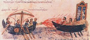
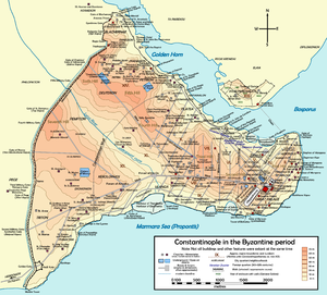
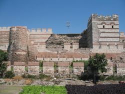
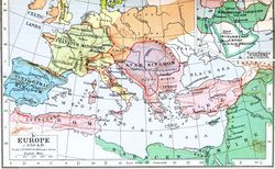
الحصار العربي الأول للقسطنطينية أو معركة سيلايوم البحرية حدثت في العام 677 الميلادي بين العرب المسلمين و الإمبراطورية البيزنطية، حدثت هذه المعركة البحرية بالتزامن مع سلسلة من المعارك البرية في سوريا والأناضول.
. . . . . . . . . . . . . . . . . . . . . . . . . . . . . . . . . . . . . . . . . . . . . . . . . . . . . . . . . . . . . . . . . . . . . . . . . . . . . . . . . . . . . . . . . . . . . . . . . . . . . . . . . . . . . . . . . . . . . . . . . . . . . . . . . . . . . . . . . . . . . . . . . . . . . . . . . . . . . . . . . . . . . . . .
الخلفية
التحركات الأولى: حملتي 672 و 673
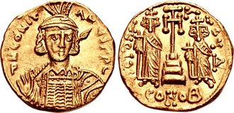
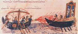
الوقع الثقافي

المراجع
- ^ Haldon 1990, p. 64.
المصادر
- Brooks, E.W. (1898). "The Arabs in Asia Minor (641–750), from Arabic Sources". The Journal of Hellenic Studies. The Society for the Promotion of Hellenic Studies. XVIII: 182–208.
{{cite journal}}: Invalid|ref=harv(help) - Canard, Marius (1926). "Les expéditions des Arabes contre Constantinople dans l'histoire et dans la légende" [The Expeditions of the Arabs Against Constantinople in History and Legend]. Journal Asiatique (in French) (208): 61–121. ISSN 0021-762X.
{{cite journal}}: Invalid|ref=harv(help)CS1 maint: unrecognized language (link) - El-Cheikh, Nadia Maria (2004). Byzantium Viewed by the Arabs. Cambridge, Massachusetts: Harvard Center for Middle Eastern Studies. ISBN 978-0-932885-30-2.
{{cite book}}: Invalid|ref=harv(help) - Foster, John (1939). The Church of the T'ang Dynasty. London: Society for Promoting Christian Knowledge. OCLC 3790642.
{{cite book}}: Invalid|ref=harv(help) - Haldon, John F. (1990). Byzantium in the Seventh Century: The Transformation of a Culture. Revised Edition. Cambridge, United Kingdom: Cambridge University Press. ISBN 978-0521319171.
{{cite book}}: Invalid|ref=harv(help) - Howard-Johnston, James (2010). Witnesses to a World Crisis: Historians and Histories of the Middle East in the Seventh Century. Oxford: Oxford University Press. ISBN 978-0-19-920859-3.
{{cite book}}: Invalid|ref=harv(help) - Jankowiak, Marek (2013). "The First Arab Siege of Constantinople". In Zuckerman, Constantin (ed.). Travaux et mémoires, Vol. 17: Constructing the Seventh Century. Paris: Association des Amis du Centre d’Histoire et Civilisation de Byzance. pp. 237–320.
{{cite book}}: External link in|chapterurl=|ref=harv(help); Unknown parameter|chapterurl=ignored (|chapter-url=suggested) (help) - Jenkins, Philip (2008). The Lost History of Christianity: the Thousand-Year Golden Age of the Church in the Middle East, Africa, and Asia – and How It Died. New York: Harper Collins. ISBN 978-0-06-147280-0.
{{cite book}}: Invalid|ref=harv(help) - Kaegi, Walter E. (2008). "Confronting Islam: Emperors versus Caliphs (641–c. 850)". In Shepard, Jonathan (ed.). The Cambridge History of the Byzantine Empire c. 500–1492. Cambridge: Cambridge University Press. pp. 365–394. ISBN 978-0-52-183231-1.
{{cite book}}: Invalid|ref=harv(help) - Lilie, Ralph-Johannes (1976). Die byzantinische Reaktion auf die Ausbreitung der Araber. Studien zur Strukturwandlung des byzantinischen Staates im 7. und 8. Jhd [Byzantine Reaction to the Expansion of the Arabs. Studies on the Structural Change of the Byzantine State in the 7th and 8th Cent.] (in German). Munich: Institut für Byzantinistik und Neugriechische Philologie der Universität München. OCLC 797598069.
{{cite book}}: Invalid|ref=harv(help)CS1 maint: unrecognized language (link) - Mango, Cyril; Scott, Roger (1997). The Chronicle of Theophanes Confessor. Byzantine and Near Eastern History, AD 284–813. Oxford: Oxford University Press. ISBN 978-0-19-822568-3.
{{cite book}}: Invalid|ref=harv(help) - Olster, David (1995). "Theodosius Grammaticus and the Arab Siege of 674-78". Byzantinoslavica. 56 (1): 23–28. ISSN 0007-7712.
{{cite journal}}: Invalid|ref=harv(help) - Stratos, Andreas N. (1978). Byzantium in the Seventh Century, Volume IV: 668–685. Amsterdam: Adolf M. Hakkert. ISBN 9789025606657.
{{cite book}}: Invalid|ref=harv(help) - Stratos, Andreas N. (1983). "Siège ou blocus de Constantinople sous Constantin IV" [Siege or Blockade of Constantinople under Constantine IV]. Jahrbuch der österreichischen Byzantinistik (in French). Vienna: Verlag der Österreichischen Akademie der Wissenschaften. 33: 89–107. ISSN 0378-8660.
{{cite journal}}: Invalid|ref=harv(help)CS1 maint: unrecognized language (link) - Treadgold, Warren (1997). A History of the Byzantine State and Society. Stanford, California: Stanford University Press. ISBN 0-8047-2630-2.
- Turnbull, Stephen (2004). The Walls of Constantinople, AD 324–1453. Oxford: Osprey Publishing. ISBN 978-1-84176-759-8.
{{cite book}}: Invalid|ref=harv(help) - Yule, Henry (1915). Cathay and the Way Thither: Being a Collection of Medieval Notices of China, Vol I: Preliminary Essay on the Intercourse Between China and the Western Nations Previous to the Discovery of the Cape Route. London: Hakluyt Society.
{{cite book}}: Invalid|ref=harv(help)
. . . . . . . . . . . . . . . . . . . . . . . . . . . . . . . . . . . . . . . . . . . . . . . . . . . . . . . . . . . . . . . . . . . . . . . . . . . . . . . . . . . . . . . . . . . . . . . . . . . . . . . . . . . . . . . . . . . . . . . . . . . . . . . . . . . . . . . . . . . . . . . . . . . . . . . . . . . . . . . . . . . . . . . .
وصلات خارجية
- Radic, Radivoj (2008). "Two Arabian sieges of Constantinople (674–678; 717/718)". Encyclopedia of the Hellenic World, Constantinople. Foundation of the Hellenic World. Retrieved 9 July 2012.
Coordinates: 41°00′44″N 28°58′34″E / 41.01224°N 28.976018°E
- CS1 errors: unsupported parameter
- Coordinates on Wikidata
- نزاعات عقد 670
- عقد 670 في الامبراطورية البيزنطية
- 674
- 678
- Amphibious operations
- Naval battles involving the Byzantine Empire
- Naval battles involving the Umayyad Caliphate
- Sieges involving the Byzantine Empire
- Sieges involving the Umayyad Caliphate
- Sieges of Constantinople
- Sieges of the Arab–Byzantine wars
- معارك بحرية
- الامبراطورية البيزنطية
- معارك الدولة الأموية

