توازن مرتد
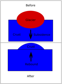
التوازن المرتد Post-glacial rebound ، هو ارتفاع جزء من القشرة الأرضية، نتيجة إزالة وزن كبير مثل جليد المثالج[1] أثناء last glacial period, which had caused isostatic depression. Post-glacial rebound and isostatic depression are phases of glacial isostasy (glacial isostatic adjustment, glacioisostasy), the deformation of the Earth's crust in response to changes in ice mass distribution.[2] The direct raising effects of post-glacial rebound are readily apparent in parts of Northern Eurasia, Northern America, Patagonia, and Antarctica. However, through the processes of ocean siphoning and continental levering, the effects of post-glacial rebound on sea level are felt globally far from the locations of current and former ice sheets.[3]
نظرة عامة
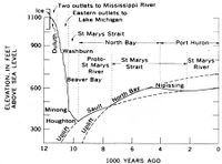
During the last glacial period, much of northern Europe, Asia, North America, Greenland and Antarctica was covered by ice sheets, which reached up to three kilometres thick during the glacial maximum about 20,000 years ago. The enormous weight of this ice caused the surface of the Earth's crust to deform and warp downward, forcing the viscoelastic mantle material to flow away from the loaded region. At the end of each glacial period when the glaciers retreated, the removal of this weight led to slow (and still ongoing) uplift or rebound of the land and the return flow of mantle material back under the deglaciated area. Due to the extreme viscosity of the mantle, it will take many thousands of years for the land to reach an equilibrium level.
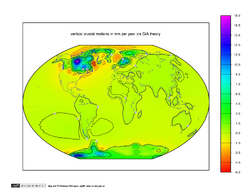
The uplift has taken place in two distinct stages. The initial uplift following deglaciation was almost immediate due to the elastic response of the crust as the ice load was removed. After this elastic phase, uplift proceeded by slow viscous flow at an exponentially decreasing rate.[citation needed] Today, typical uplift rates are of the order of 1 cm/year or less. In northern Europe, this is clearly shown by the GPS data obtained by the BIFROST GPS network;[4] for example in Finland, the total area of the country is growing by about seven square kilometers per year.[5][6] Studies suggest that rebound will continue for at least another 10,000 years. The total uplift from the end of deglaciation depends on the local ice load and could be several hundred metres near the centre of rebound.
Recently, the term "post-glacial rebound" is gradually being replaced by the term "glacial isostatic adjustment". This is in recognition that the response of the Earth to glacial loading and unloading is not limited to the upward rebound movement, but also involves downward land movement, horizontal crustal motion,[4][7] changes in global sea levels[8] and the Earth's gravity field,[9] induced earthquakes,[10] and changes in the Earth's rotation.[11] Another alternate term is "glacial isostasy", because the uplift near the centre of rebound is due to the tendency towards the restoration of isostatic equilibrium (as in the case of isostasy of mountains). Unfortunately, that term gives the wrong impression that isostatic equilibrium is somehow reached, so by appending "adjustment" at the end, the motion of restoration is emphasized.
الآثار
Post-glacial rebound produces measurable effects on vertical crustal motion, global sea levels, horizontal crustal motion, gravity field, Earth's rotation, crustal stress, and earthquakes. Studies of glacial rebound give us information about the flow law of mantle rocks, which is important to the study of mantle convection, plate tectonics and the thermal evolution of the Earth. It also gives insight into past ice sheet history, which is important to glaciology, paleoclimate, and changes in global sea level. Understanding postglacial rebound is also important to our ability to monitor recent global change.
الحركة الرأسية للقشرة الأرضية
Erratic boulders, U-shaped valleys, drumlins, eskers, kettle lakes, bedrock striations are among the common signatures of the Ice Age. In addition, post-glacial rebound has caused numerous significant changes to coastlines and landscapes over the last several thousand years, and the effects continue to be significant.
In Sweden, Lake Mälaren was formerly an arm of the Baltic Sea, but uplift eventually cut it off and led to its becoming a freshwater lake in about the 12th century, at the time when Stockholm was founded at its outlet. Marine seashells found in Lake Ontario sediments imply a similar event in prehistoric times. Other pronounced effects can be seen on the island of Öland, Sweden, which has little topographic relief due to the presence of the very level Stora Alvaret. The rising land has caused the Iron Age settlement area to recede from the Baltic Sea, making the present day villages on the west coast set back unexpectedly far from the shore. These effects are quite dramatic at the village of Alby, for example, where the Iron Age inhabitants were known to subsist on substantial coastal fishing.
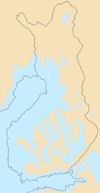
As a result of post-glacial rebound, the Gulf of Bothnia is predicted to eventually close up at Kvarken in more than 2,000 years.[12] The Kvarken is a UNESCO World Natural Heritage Site, selected as a "type area" illustrating the effects of post-glacial rebound and the holocene glacial retreat.
In several other Nordic ports, like Tornio and Pori (formerly at Ulvila), the harbour has had to be relocated several times. Place names in the coastal regions also illustrate the rising land: there are inland places named 'island', 'skerry', 'rock', 'point' and 'sound'. For example, Oulunsalo "island of Oulujoki"[13] is a peninsula, with inland names such as Koivukari "Birch Rock", Santaniemi "Sandy Cape", and Salmioja "the brook of the Sound". (Compare [1] and [2].)
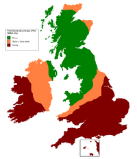
In Great Britain, glaciation affected Scotland but not southern England, and the post-glacial rebound of northern Great Britain (up to 10 cm per century) is causing a corresponding downward movement of the southern half of the island (up to 5 cm per century). This will eventually lead to an increased risk of floods in southern England and south-western Ireland.[14]
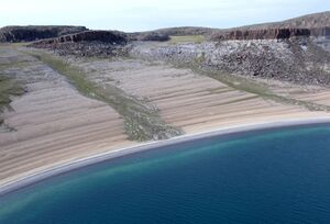
Since the glacial isostatic adjustment process causes the land to move relative to the sea, ancient shorelines are found to lie above present day sea level in areas that were once glaciated. On the other hand, places in the peripheral bulge area which was uplifted during glaciation now begins to subside. Therefore, ancient beaches are found below present day sea level in the bulge area. The "relative sea level data", which consists of height and age measurements of the ancient beaches around the world, tells us that glacial isostatic adjustment proceeded at a higher rate near the end of deglaciation than today.
The present-day uplift motion in northern Europe is also monitored by a GPS network called BIFROST.[4][15][16] Results of GPS data show a peak rate of about 11 mm/year in the north part of the Gulf of Bothnia, but this uplift rate decreases away and becomes negative outside the former ice margin.
In the near field outside the former ice margin, the land sinks relative to the sea. This is the case along the east coast of the United States, where ancient beaches are found submerged below present day sea level and Florida is expected to be submerged in the future.[8] GPS data in North America also confirms that land uplift becomes subsidence outside the former ice margin.[7]
مستويات البحار العالمية
To form the ice sheets of the last Ice Age, water from the oceans evaporated, condensed as snow and was deposited as ice in high latitudes. Thus global sea level fell during glaciation.
The ice sheets at the last glacial maximum were so massive that global sea level fell by about 120 metres. Thus continental shelves were exposed and many islands became connected with the continents through dry land. This was the case between the British Isles and Europe (Doggerland), or between Taiwan, the Indonesian islands and Asia (Sundaland). A land bridge also existed between Siberia and Alaska that allowed the migration of people and animals during the last glacial maximum.[8]
The fall in sea level also affects the circulation of ocean currents and thus has important impact on climate during the glacial maximum.
During deglaciation, the melted ice water returns to the oceans, thus sea level in the ocean increases again. However, geological records of sea level changes show that the redistribution of the melted ice water is not the same everywhere in the oceans. In other words, depending upon the location, the rise in sea level at a certain site may be more than that at another site. This is due to the gravitational attraction between the mass of the melted water and the other masses, such as remaining ice sheets, glaciers, water masses and mantle rocks[8] and the changes in centrifugal potential due to Earth's variable rotation.[17]
الحركة الأفقية للقشرة الأرضية
الإمالة
Gravity field
مسند عمودي
دوران الأرض
State of stress and intraplate earthquakes
الاحتباس الحراري الحديث
تطبيقات
الاكتشاف
Before the eighteenth century, it was thought, in Sweden, that sea levels were falling. On the initiative of Anders Celsius a number of marks were made in rock on different locations along the Swedish coast. In 1765 it was possible to conclude that it was not a lowering of sea levels but an uneven rise of land. In 1865 Thomas Jamieson came up with a theory that the rise of land was connected with the ice age that had been first discovered in 1837. The theory was accepted after investigations by Gerard De Geer of old shorelines in Scandinavia published in 1890.[18][19][20]
الوضع القانوني
صياغة: معادلة مستوى البحر
The sea-level equation (SLE) is a linear integral equation that describes the sea-level variations associated with the PGR. The basic idea of the SLE dates back to 1888, when Woodward published his pioneering work on the form and position of mean sea level,[21] and only later has been refined by Platzman [22] and Farrell [23] in the context of the study of the ocean tides. In the words of Wu and Peltier,[24] the solution of the SLE yields the space– and time–dependent change of ocean bathymetry which is required to keep the gravitational potential of the sea surface constant for a specific deglaciation chronology and viscoelastic earth model. The SLE theory was then developed by other authors as Mitrovica & Peltier,[25] Mitrovica et al.[26] and Spada & Stocchi.[27] In its simplest form, the SLE reads
where is the sea–level change, is the sea surface variation as seen from Earth's center of mass, and is vertical displacement.
In a more explicit form the SLE can be written as follow:
where is colatitude and is longitude, is time, and are the densities of ice and water, respectively, is the reference surface gravity, is the sea–level Green's function (dependent upon the and viscoelastic load–deformation coefficients - LDCs), is the ice thickness variation, represents the eustatic term (i.e. the ocean–averaged value of ), and denote spatio-temporal convolutions over the ice- and ocean-covered regions, and the overbar indicates an average over the surface of the oceans that ensures mass conservation.
انظر أيضا
- Holocene glacial retreat
- Raised beach, also known as marine terrace
- Physical impacts of climate change
- Stress (mechanics)
- Isostatic depression - The opposite of isostatic rebound
المصادر
- ^ عبد الجليل هويدي، محمد أحمد هيكل (2004). أساسيات الجيولوجيا التاريخية. مكتبة الدار العربية للكتب.
- ^ Milne, G.; Shennan, I. (2013). "Isostasy: Glaciation-Induced Sea-Level Change". In Elias, Scott A.; Mock, Cary J. (eds.). Encyclopedia of Quaternary Science. Vol. 3 (2nd ed.). Elsevier. pp. 452–459. doi:10.1016/B978-0-444-53643-3.00135-7. ISBN 978-0-444-53643-3.
- ^ Milne, G.A., and J.X. Mitrovica (2008) Searching for eustasy in deglacial sea-level histories. Quaternary Science Reviews. 27:2292–2302.
- ^ أ ب ت Johansson, J.M.; et al. (2002). "Continuous GPS measurements of postglacial adjustment in Fennoscandia. 1. Geodetic results". Journal of Geophysical Research. 107 (B8): 2157. Bibcode:2002JGRB..107.2157J. doi:10.1029/2001JB000400.[dead link]
- ^ "e_Opin oppikirjat: eMaantieto: Maankohoaminen". Peda.net (in الفنلندية). Retrieved July 12, 2021.[dead link]
- ^ "Maa kohoaa ja maisema muuttuu". e-Opin kustantama e-kirja (in الفنلندية). Retrieved July 12, 2021.
- ^ أ ب Sella, G.F.; Stein, S.; Dixon, T.H.; Craymer, M.; et al. (2007). "Observation of glacial isostatic adjustment in "stable" North America with GPS". Geophysical Research Letters. 34 (2): L02306. Bibcode:2007GeoRL..3402306S. doi:10.1029/2006GL027081.
- ^ أ ب ت ث Peltier, W.R. (1998). "Postglacial variations in the level of the sea: implications for climate dynamics and solid-earth geophysics". Reviews of Geophysics. 36 (4): 603–689. Bibcode:1998RvGeo..36..603P. doi:10.1029/98RG02638.
- ^ Mitrovica, J.X.; W.R. Peltier (1993). "Present-day secular variations in zonal harmonics of the Earth's geopotential". Journal of Geophysical Research. 98 (B3): 4509–4526. Bibcode:1993JGR....98.4509M. doi:10.1029/92JB02700.
- ^ Wu, P.; P. Johnston (2000). "Can deglaciation trigger earthquakes in N. America?". Geophysical Research Letters. 27 (9): 1323–1326. Bibcode:2000GeoRL..27.1323W. doi:10.1029/1999GL011070.
- ^ Wu, P.; W.R.Peltier (1984). "Pleistocene deglaciation and the earth's rotation: a new analysis". Geophysical Journal of the Royal Astronomical Society. 76 (3): 753–792. Bibcode:1984GeoJ...76..753W. doi:10.1111/j.1365-246X.1984.tb01920.x.
- ^ Tikkanen, Matti; Oksanen, Juha (2002). "Late Weichselian and Holocene shore displacement history of the Baltic Sea in Finland". Fennia. 180 (1–2). Archived from the original on October 20, 2017. Retrieved December 22, 2017.
- ^ "Oulunsalon kirkon seudun paikannimistö" (in الفنلندية). Archived from the original on 2008-02-21. Retrieved 2008-05-09.
- ^ Gray, Louise (7 October 2009). "England is sinking while Scotland rises above sea levels, according to new study". Telegraph. Archived from the original on 17 June 2012. Retrieved 10 April 2012.
- ^ "Observed Radial Rates from GPS". BIFROST Associated GPS Networks. Archived from the original on 2012-08-19. Retrieved 2008-05-09.
- ^ "BIFROST". Archived from the original on 2012-05-01. Retrieved 2008-05-09.
- ^ Mitrovica, J.X.; G.A. Milne & J.L. Davis (2001). "Glacial isostatic adjustment on a rotating earth". Geophysical Journal International. 147 (3): 562–578. Bibcode:2001GeoJI.147..562M. doi:10.1046/j.1365-246x.2001.01550.x.
- ^ De Geer, Gerard (1890). "Om Skandinaviens nivåförändringar under qvartärperioden". Geologiska Föreningen i Stockholm Förhandlingar (in Swedish). 10 (5): 366–379. doi:10.1080/11035898809444216.
{{cite journal}}: CS1 maint: unrecognized language (link) - ^ de Geer, Gerard (1910). "Quaternary Sen-bottoms in Western Sweden". Geologiska Föreningen i Stockholm Förhandlingar. 32 (5): 1139–1195. doi:10.1080/11035891009442325.
- ^ De Geer, Gerard (1924). "Post-Algonkian Oscillations of Land in Feunoscandia". Geologiska Föreningen i Stockholm Förhandlingar. 46 (3–4): 316–324. doi:10.1080/11035892409442370.
- ^ Woodward, R. S., 1888. On the form and position of mean sea level. United States Geol. Survey Bull., 48, 87170.
- ^ Platzman , G. W., 1971. Ocean tides. In Lectures in Applied Mathematics, 14, part 2, pp. 239292, American Mathematical Society, Providence, RI.
- ^ Farrell, W. E., 1973. Earth tides, ocean tides and tidal loading. Phil. Trans. R. Soc. Lond. A, 274, 253259.
- ^ Wu, P., and W. R. Peltier. Glacial isostatic adjustment and the free–air gravity anomaly as a constraint on deep mantle viscosity. Geophys. J. R. Astron. Soc., 74, 377449, 1983.
- ^ Mitrovica, J. X. & Peltier, W. R., 1991. On postglacial geoid subsidence over the equatorial ocean. J. geophys. Res., 96, 20,05320,071.
- ^ Mitrovica, J. X., Davis, J. L. & Shapiro, I. I., 1994. A spectral formal- ism for computing three–dimensional deformations due to surface loads. J. geophys. Res., 99, 70577073.
- ^ Spada G. & Stocchi, P., 2006. The Sea Level Equation, Theory and Numerical Examples. ISBN 88-548-0384-7, 96 pp., Aracne, Roma.
- Lambeck, K.; C. Smither; P. Johnston (July 1998). "Sea-level change, glacial rebound and mantle viscosity for northern Europe". Geophysical Journal International. 134 (1): 102–144. Bibcode:1998GeoJI.134..102L. doi:10.1046/j.1365-246x.1998.00541.x.
- Garai, J. (2003). "Post glacial rebounds measure the viscosity of the lithosphere". arXiv:physics/0308002.
- King Huber, N. (1973). "Glacial and Postglacial Geologic History of Isle Royale National Park, Michigan". Geological Survey Professional Paper 754-A. National Park Service. Archived from the original on 2011-03-17. Retrieved 2012-02-18.
- The Coordinating Committee On Great Lakes Basic Hydraulic and Hydrologic Data (November 2001). "Apparent Vertical Movement Over the Great Lakes — Revisited" (PDF). Geodetic Survey Division of Natural Resources Canada.
