جبال الخليل
| جبال الخليل | |
|---|---|
| Harei Yehuda / جبال يهودا | |
 Location | |
| أعلى نقطة | |
| القمة | جبل حلحول |
| الارتفاع | 1،026 m (3،366 ft) |
| الإحداثيات | 31°40′N 35°10′E / 31.667°N 35.167°E[1] |
| الجغرافيا | |
| السلسلة الأم | الوادي المتصدع الأكبر |
| الجيولوجيا | |
| عمر الصخر | Late Cretaceous |
| نوع الصخر | Terra rossa, حجر جيري |
| التسلق | |
| أسهل السبل | طريق الآباء (طريق الحافة) |
جبال الخليل أو جبال يهودا הרי יהודה في التاريخ والثقافة العبرية تطلق بشكل أساسي على جبال الخليل ومن ناحية جغرافية فهي المنطقة الممتدة من تل العاصور شمالاً إلى وادي بئر السبع جنوباً، وتمتد إلى صحراء الضفة الغربية (صحراء يهودا) شرقاً، وهي تشكل قلب مملكة يهوذا.
تتكون الجبال من الحجر الجيري و الدولوميت. والجزء الآخر هو صحراء.
من المعتاد تقسيم جبال يهودا لثلاثة أجزاء: الشمال حيث هناك تل العاصور ويرتفع 1016 متر فوق مستوى سطح البحر . المركز - وهي منطقة منخفضة نسبياً وتبلغ ذروتها حوالي 918 متراً. والجنوب - جبل الخليل ، وتبلغ ذروتها بلدة حلحول شمال الخليل بارتفاع يصل إلى 1،026 متر فوق مستوى سطح البحر[2].
المدن الكبرى في يهودا : القدس ، الخليل ، بيت لحم ، رام الله و مستوطنات إسرائيلية هما معاليه أدوميم وبيتار عيليت.
في يوليو 1965 أعلنت إسرائيل جزء من "جبال يهودا" حديقة وطنية ومساحتها حوالي 26،000 هكتار تركزت في تلال القدس.
الجغرافيا
The Judaean mountains are part of a more extended range that runs in a north-south direction. The ridge consists of the Samarian Hills in its northern part, and of the Judaean mountains in its southern part, the two segments meeting at the latitude of Ramallah. The westward descent from the hard limestone country of the Judaean mountains towards the coastal plain is by way of a longitudinal trough of fosse cut through chalk, followed by the low, rolling soft limestone hills of the Shephelah, while eastwards the landscape falls steeply towards the Jordan Rift Valley. The southern end of the mountain range is at Beersheba[3][4][5] in the northern part of the Negev, where the mountains slope down into the Beersheba-Arad valley.[citation needed] The average height of the Judaean mountains is of 900 متر (2،953 ft), and they encompass the cities of Ramallah, Jerusalem, Bethlehem and Hebron.[citation needed] The northern section of the Judaean mountains is referred to as Jerusalem Hills, and the southern one as Hebron Hills.[citation needed]
The Judaean Mountains were heavily forested in antiquity. The range is mostly composed of terra rossa soils over hard limestones.[2][6]
الجيولوجيا والمستحاثات
The Judaean Mountains are the surface expression of a series of monoclinic folds which trend north-northwest through Israel. The folding is the central expression of the Syrian Arc belt of anticlinal folding that began in the Late Cretaceous Period in northeast Africa and southwest Asia. The Syrian Arc extends east-northeast across the Sinai, turns north-northeast through Israel and continues the east-northeast trend into Syria. The Israeli segment parallels the Dead Sea Transform which lies just to the east.[7][8] The uplift events that created the mountain occurred in two phases one in the Late Eocene-Early Oligocene and second in the Early Miocene.[9]
In prehistoric times, animals no longer found elsewhere in the Levant region were found here, including elephants, rhinoceroses, giraffes and wild Asian water buffalo.[10]
The range has karst topography including a stalactite cave in Nahal Sorek National Park between Jerusalem and Beit Shemesh and the area surrounding Ofra, where fossils of prehistoric flora and fauna were found.
في التناخ
According to the Hebrew Bible, the Judean mountains were the allotment of the Tribe of Judah and the heartland of the former Kingdom of Judah.[11][12]
النقل
The main freeway between Tel Aviv and Jerusalem, which further extends to Jordan Valley as regular road, Highway 1, passes through Judean Mountains, between Beit Shemesh and Jerusalem.
An Israel Railways line, Jaffa-Jerusalem railway runs from Beit Shemesh along the Brook of Sorek and Valley of Rephaim into Jerusalem Malha Train Station. The line has since been largely replaced by Tel Aviv-Jerusalem railway, which utilizes tunnels and bridges through Judean Mountains, runs up to 160km/h (99 mph) between Ben Gurion Airport and Jerusalem-Yitzhak Navon railway station.
صناعة النبيذ
The Judean Mountains have been associated with winemaking for thousands of years, as evidenced by the abundance of ancient winepresses, references to viticulture in ancient texts like the Hebrew Bible, and archaeological findings such as the Arad ostraca, written by Judahite soldiers in the late 7th century BCE.[13][14] Nevertheless, with the Muslim conquest of the Levant in the 7th century, and particularly during the later Mamluk rule in the Middle Ages, a significant decline in winemaking activities occurred, ultimately leading to a complete prohibition of winemaking.[15] It wasn't until the 1980s that the Judaean Mountains witnessed a remarkable resurgence in winemaking, driven by Israeli entrepreneurs. Today, the area is renowned for its boutique wineries. This region's combination of Mediterranean microclimates, terra rossa clay soil, and high-altitude vineyards has also propelled it into the spotlight as a burgeoning center for quality wine production. In recent decades, wines originating from this area have garnered international recognition.[13]
معرض الصور
-
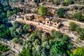
 The Judaean Mountains between Jerusalem and Ma'ale Adumim
 -
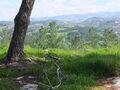
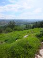 View from hilltop overlooking Wadi es-Ṣur, an extension of the Elah Valley in Israel
 -
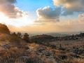 المنظر من بيت مئير في جبال الخليل
 -
 Elah Valley (Wadi es-Sur) near Adullam with the Judean mountains in the background
 -
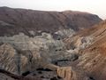 تلال الخليل كما تبدو من البحر الميت
 -
 Idyllic scene in the Judean mountains, overlooking the village of Khirbet ed-Deir which sits along the Green Line
 -
 The ruined structure of an ancient house, near Neve Michael
 -
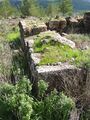
 Remains of Sataf village


انظر أيضاً
مراجع
- ^ Judaean_Mountains - Mapcarta
- ^ أ ب ت Encyclopedia of Prehistory: South and Southwest Asia.
{{cite book}}: Cite has empty unknown parameters:|lay-date=,|subscription=,|nopp=,|last-author-amp=,|name-list-format=,|lay-source=,|registration=, and|lay-summary=(help) - ^ Palestine: Land, Encyclopaedia Britannica
- ^ Stone, Lawson G. (2016). Philip W. Comfort (ed.). Judges (Judges 13:1-25). Vol. 3. Tyndale House. pp. 381–382. ISBN 9781414398792. Retrieved 11 December 2019.
{{cite book}}:|work=ignored (help) - ^ Jerusalem Hills - Mapcarta
- ^ Arieh Singer (2007). The Soils of Israel. Springer. pp. 129, 143.
- ^ Abd El-Motaal, Essam; Kusky, Timothy M. (2003). Tectonic Evolution of the Intraplate S-Shaped Syrian Arc Fold-Thrust Belt of the Middle East Region in the Context of Plate Tectonics (PDF). Archived from the original (PDF) on 2016-03-03. Retrieved 2012-02-23.
{{cite book}}:|work=ignored (help) - ^ Flexer A. (1989). "Late Cretaceous evolution of the Judean Mountains as indicated by ostracodes". Terra Nova. 1 (4): 349–358. Bibcode:1989TeNov...1..349F. doi:10.1111/j.1365-3121.1989.tb00385.x.
- ^ Bar, Oded; Zilberman, Ezra; Feinstein, Shimon; Calvo, Ran; Gvirtzman, Zohan (2016). "The uplift history of the Arabian Plateau as inferred from geomorphologic analysis of its northwestern edge". Tectonophysics. 671: 9–23. Bibcode:2016Tectp.671....9B. doi:10.1016/j.tecto.2016.01.004.
- ^ "History of Jerusalem from Its Beginning to David". Biu.ac.il. 1997-03-06. Retrieved 2012-02-13.
- ^ "Cambridge History of Judaism". Cambridge.org. p. 210. Retrieved 16 August 2011. "In both the Idumaean and the Ituraean alliances, and in the annexation of Samaria, the Judaeans had taken the leading role. They retained it. The whole political–military–religious league that now united the hill country of Palestine from Dan to Beersheba, whatever it called itself, was directed by, and soon came to be called by others, 'the Ioudaioi'"
- ^ A History of the Jewish People, edited by Haim Hillel Ben-Sasson, page 226, "The name Judea no longer referred only to...."
- ^ أ ب Todd, Cathrine (2019-04-17). "The Raw Beauty Of The Wines From The Judean Hills". Forbes (in الإنجليزية). Retrieved 2023-09-02.
- ^ Faigenbaum-Golovin, Shira; Mendel-Geberovich, Anat; Shaus, Arie; Sober, Barak; Cordonsky, Michael; Levin, David; Moinester, Murray; Sass, Benjamin; Turkel, Eli; Piasetzky, Eli; Finkelstein, Israel (2017-06-14). "Multispectral imaging reveals biblical-period inscription unnoticed for half a century". PLOS ONE (in الإنجليزية). 12 (6): e0178400. doi:10.1371/journal.pone.0178400. ISSN 1932-6203. PMC 5470672. PMID 28614416.
- ^ Sivan, Aviad; Rahimi, Oshrit; Lavi, Bar; Salmon‐Divon, Mali; Weiss, Ehud; Drori, Elyashiv; Hübner, Sariel (2021). "Genomic evidence supports an independent history of Levantine and Eurasian grapevines". Plants, People, Planet (in الإنجليزية). 3 (4): 414–427. doi:10.1002/ppp3.10197. ISSN 2572-2611.
- Pages using gadget WikiMiniAtlas
- CS1 errors: periodical ignored
- Short description is different from Wikidata
- Coordinates on Wikidata
- Wikidata value to be checked for Infobox mountain
- Pages using infobox mountain with unknown parameters
- جبال التوراة
- جبال الضفة الغربية
- جبال إسرائيل
- جغرافيا فلسطين
- سلاسل جبال إسرائيل