دوبلنگ
دوبلنگ
Döbling | |
|---|---|
19th District of Vienna | |
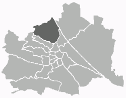
 Location of the district within Vienna | |
| البلد | النمسا |
| المدينة | ڤيينا |
| الحكومة | |
| • District Director | Adolf Tiller (ÖVP) |
| • First Deputy | Hannes Trinkl (ÖVP) |
| • Second Deputy | Gerald Kopecky (SPÖ) |
| • Representation (46 Members) | ÖVP 18, SPÖ 15, FPÖ 7, Green 6 |
| المساحة | |
| • الإجمالي | 24٫90 كم² (9٫61 ميل²) |
| التعداد (2016-01-01)[1] | |
| • الإجمالي | 71٬596 |
| • الكثافة | 2٬900/km2 (7٬400/sq mi) |
| Postal code | A-1190 |
| Address of District Office | Gatterburggasse 14 A-1190 Wien |
| الموقع الإلكتروني | www.wien.gv.at/bezirke/doebling/ |
دوبلنگ (Döbling ؛ النطق الألماني: [ˈdøːblɪŋ] (![]() listen)) هي 19th District in the city of Vienna, Austria (German: 19. Bezirk, Döbling, Doebling). It is located on the north end from the central districts, north of the districts Alsergrund and Währing.[2] Döbling has some heavily populated urban areas with many residential buildings, and borders the Vienna Woods.[1][2]
It hosts some of the most expensive residential areas such as Grinzing, Sievering, Neustift am Walde and Kaasgraben and is also the site of a large number of Heurigen restaurants. There are also some large Gemeindebauten, including Vienna's most famous one, the Karl-Marx-Hof.
listen)) هي 19th District in the city of Vienna, Austria (German: 19. Bezirk, Döbling, Doebling). It is located on the north end from the central districts, north of the districts Alsergrund and Währing.[2] Döbling has some heavily populated urban areas with many residential buildings, and borders the Vienna Woods.[1][2]
It hosts some of the most expensive residential areas such as Grinzing, Sievering, Neustift am Walde and Kaasgraben and is also the site of a large number of Heurigen restaurants. There are also some large Gemeindebauten, including Vienna's most famous one, the Karl-Marx-Hof.
Also located in Döbling is the American International School of Vienna, Lauder Business School and Q19 Shopping Center.
الجغرافيا
الموقع
Döbling is located in the northwest of Vienna and spans the slope of the Wienerwald (Vienna Forest) to the Danube and the Danube Canal that make up the border of the district in the east. The Danube forms the border between Döbling and the district Floridsdorf, and the canal forms the border to the district Brigittenau. At the Gürtel Bridge, over the Donau Canal, the district border splits off and separates Döbling in the south along the Vienna Belt from the district Alsergrund. At the Schrottenbachgasse the district border branches towards the northwest and separates Döbling from the district Währing along the line Währinger Park-Hasenauerstraße-Peter Jordan Straße-Starkfriedgasse -Sommerhaidenweg. There is then a short border to the district Hernals at the edge of Vienna.
أشهر السكان
- لودڤيگ ڤان بيتهوڤن (1770–1827)، ملحن (Grinzinger Straße 64; Pfarrplatz 2; Probusgasse 6 (the Heiligenstadt Testament was drafted here); Döblinger Hauptstraße 92 (Beethoven composed substantial parts of the Eroica Symphony here)
- Elias Canetti (1905–1994), writer, Nobel Prize in Literature 1981 (Himmelstraße 30)
- كورت گودل (1906–1978)، عالم رياضيات ومنطق وفيلسوف نمساوي-أمريكي (Himmelstraße 43)
- محمد البرادعي (ولد 1942)، المدير العام الأسبق للوكالة الدولية للطاقة الذرية (IAEA)، الحائز على جائزة نوبل
- Franz Grillparzer (1791–1872), poet (Grinzinger Straße 64)
- برونو كرايسكي (1911, Margareten, Vienna - 1990)، مستشار النمسا الأسبق. (Armbrustergasse 15)
- ألفرد فون كريمر (1828 - 1889)، مستعرب وقنصل في مصر
- Joseph Lanner (1801, Neubau, Vienna - 1843)، ملحن (Gymnasiumstraße 87, building demolished in the late 19th century)
- Nikolaus Lenau (1802–1850), author
- كولومان موزر (1868, Wieden, Vienna - 1918)، العضو المؤسس في حركة انفصال ڤيينا
- Helmut Qualtinger (1928, Alsergrund, Vienna - 1986), actor
- رومي شنايدر (1938–1982)، ممثلة
- يوهان شتراوس الأول (1804–1849)، ملحن (Dreimarksteingasse 13)
- يوهان شتراوس الثاني (1825–1899)، ملحن (Dreimarksteingasse 13)
- الحسين بن طلال، ملك الأردن (1935–1999)
- Ambros Rieder (1771–1855), composer, organist (born in Döbling) (de)
- ليون تروتسكي (1879–1940)، منظـِّر ماركسي وثوري بلشڤي (Rodlergasse 25)
- Franz Vranitzky (born 1937), former Austrian Chancellor
- Franz Werfel (writer) and his wife, Alma Mahler-Werfel
- سيمون ڤيزنتال (1908–2005)، Nazi hunter
- Hugo Wolf (1860–1903), ملحن
- هدڤيگ “هـِدي” كيزلر، الشهيرة بـ هدي لامار (1914 - 2000)، ممثلة ومخترعة (Peter-Jordan Strasse)
المعالم
الهامش
- ^ أ ب
Statistik Austria, 2008, website: "Archived copy". Archived from the original on 2008-05-30. Retrieved 2008-12-25.
{{cite web}}: CS1 maint: archived copy as title (link) (in German: population is "Einwohner"). - ^ أ ب Wien.gv.at webpage (see below: References).
المراجع
- [Parts of this article were translated from German Wikipedia.]
- "Wien - 19. Bezirk/Döbling", Wien.gv.at, 2008, webpage (15 subpages): Wien.gv.at-doebling (in German).
- Werner Filek-Wittinghausen: Gut gewerkt in Döbling: Beiträge und Dokumente zur Wirtschaftsgeschichte ("Good work in Döbling: Articles and Documents on Economic History"). Bastei, Vienna 1984, ISBN 3-85023-006-6.
- Christine Klusacek, Kurt Stimmer: Döbling. Vom Gürtel zu den Weinbergen ("Döbling: From the Belt to Weinberg Hill"). Vienna 1988, ISBN 3-900607-06-0.
- Helmut Kretschmer: Wiener Bezirkskulturführer: XIX. Döbling ("Vienna District Cultural Leader: XIX. Döbling"). Jugend und Volk, Vienna 1982, ISBN 3-7141-6235-6.
- Carola Leitner (Hg.): Döbling: Wiens 19. Bezirk in alten Fotografien ("Döbling: Vienna's 19th District in Old Photographs"). Ueberreuter, Vienna 2006, ISBN 3-8000-7177-0.
- Godehard Schwarz: Döbling. Zehn historische Spaziergänge durch Wiens 19. Bezirk ("Döbling: Ten Historic Walking Tours through Vienna's 19th District"). Vienna 2004, ISBN 3-900799-56-3.
- Franz Mazanec: Wien-Döbling. Frühere Verhältnisse. Sutton, Erfurt 2005. ISBN 978-3-89702-823-4.
وصلات خارجية
- (in ألمانية) Bezirksmuseum Döbling
- (in ألمانية) Döbling-Wien
- (in ألمانية) wien.at - 19. Bezirk/Döbling
48°15′59″N 16°19′22″E / 48.26639°N 16.32278°E قالب:Districts of Döbling قالب:Districts of Vienna
