مقاطعة تاوس، نيومكسيكو
Taos County | |
|---|---|
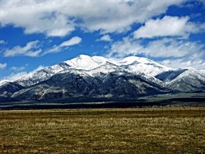
 Taos Mountain from El Prado | |
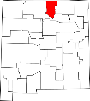
 الموقع ضمن ولاية New Mexico | |
 موقع New Mexico ضمن الولايات المتحدة | |
| الإحداثيات: 36°34′N 105°38′W / 36.57°N 105.63°W | |
| البلد | |
| State | |
| تأسست | January 9, 1852 |
| Seat | Taos |
| أكبر بلدة | Taos |
| المساحة | |
| • الإجمالي | 2٬204 ميل² (5٬710 كم²) |
| • البر | 2٬203 ميل² (5٬710 كم²) |
| • الماء | 1٫3 ميل² (3 كم²) 0.06%% |
| التعداد | |
| • Estimate (2019) | 32٬723 |
| • الكثافة | 15/sq mi (6/km2) |
| منطقة التوقيت | UTC−7 (Mountain) |
| • الصيف (التوقيت الصيفي) | UTC−6 (MDT) |
| Congressional district | 3rd |
| الموقع الإلكتروني | www |
مقاطعة تاوس إنگليزية: Taos County هي إحدى مقاطعات ولاية نيومكسيكو في الولايات المتحدة. As of the 2010 census, the population was 32,937.[1] عاصمتها تاوس.[2] The county was formed in 1852 as one of the original nine counties in New Mexico Territory.[3]
مقاطعة تاوس تضم تاوس، نيومكسيكو Micropolitan Statistical Area.
الجغرافيا
According to the U.S. Census Bureau, the county has a total area of 2،204 ميل مربع (5،710 km2), of which 2،203 ميل مربع (5،710 km2) is land and 1.3 ميل مربع (3.4 km2) (0.06%) is water.[4]
The county's highest point is the summit of Wheeler Peak at 13,161 feet (4,011 m). This is also the highest natural point in New Mexico. The county has the highest mean elevation of any U.S. county outside of Colorado at 8،510 أقدام (2،590 m), even though it ranks only 22nd overall.[5] Taos County contains 17 of New Mexico's highest 25 peaks.
المقاطعات المجاورة
- Rio Arriba County - west
- Mora County - southeast
- Colfax County - east
- Costilla County, Colorado - north
- Conejos County, Colorado - northwest
المنطقة المحمية الطبيعية
- Carson National Forest (part)
الديمغرافيا
| التعداد | Pop. | ملاحظة | %± |
|---|---|---|---|
| 1910 | 12٬008 | — | |
| 1920 | 12٬773 | 6٫4% | |
| 1930 | 14٬394 | 12٫7% | |
| 1940 | 18٬528 | 28٫7% | |
| 1950 | 17٬146 | −7٫5% | |
| 1960 | 15٬934 | −7٫1% | |
| 1970 | 17٬516 | 9٫9% | |
| 1980 | 19٬456 | 11٫1% | |
| 1990 | 23٬118 | 18٫8% | |
| 2000 | 29٬979 | 29٫7% | |
| 2010 | 32٬937 | 9٫9% | |
| 2019 (تق.) | 32٬723 | [6] | −0٫6% |
| U.S. Decennial Census[7] 1790-1960[8] 1900-1990[9] 1990-2000[10] 2010-2016[1] | |||
السياسة
Taos County is heavily Democratic. The last Republican candidate to win the county was Richard Nixon in his 1972 landslide, although the margin of victory was less than 2%.
| Year | Republican | Democratic | Third parties |
|---|---|---|---|
| 2020 | 21.6% 3,715 | 76.4% 13,121 | 2.0% 345 |
| 2016 | 17.9% 2,727 | 69.9% 10,668 | 12.2% 1,865 |
| 2012 | 17.8% 2,730 | 78.1% 11,978 | 4.1% 631 |
| 2008 | 17.0% 2,866 | 81.8% 13,816 | 1.2% 204 |
| 2004 | 24.7% 3,666 | 74.1% 10,987 | 1.2% 182 |
| 2000 | 25.2% 2,744 | 64.6% 7,039 | 10.2% 1,112 |
| 1996 | 21.2% 2,126 | 66.0% 6,635 | 12.9% 1,292 |
| 1992 | 21.2% 2,260 | 66.0% 7,051 | 12.8% 1,370 |
| 1988 | 31.3% 2,897 | 67.7% 6,271 | 1.0% 91 |
| 1984 | 44.0% 4,154 | 54.5% 5,144 | 1.4% 134 |
| 1980 | 41.7% 3,584 | 50.5% 4,346 | 7.8% 671 |
| 1976 | 40.1% 3,012 | 58.7% 4,414 | 1.2% 91 |
| 1972 | 50.5% 3,617 | 48.5% 3,472 | 1.1% 75 |
| 1968 | 49.9% 3,119 | 47.9% 2,993 | 2.2% 140 |
| 1964 | 32.2% 2,006 | 67.4% 4,204 | 0.5% 28 |
| 1960 | 41.9% 2,620 | 58.0% 3,631 | 0.1% 6 |
| 1956 | 53.0% 3,100 | 46.9% 2,743 | 0.1% 4 |
| 1952 | 48.9% 2,763 | 51.0% 2,877 | 0.1% 6 |
| 1948 | 48.6% 2,852 | 50.7% 2,977 | 0.7% 41 |
| 1944 | 50.3% 2,557 | 49.7% 2,525 | 0.0% 2 |
| 1940 | 49.1% 3,342 | 50.9% 3,463 | 0.1% 5 |
| 1936 | 48.8% 2,918 | 51.0% 3,051 | 0.2% 10 |
| 1932 | 42.2% 2,416 | 57.3% 3,277 | 0.5% 30 |
| 1928 | 57.0% 2,441 | 43.0% 1,842 | 0.0% 1 |
| 1924 | 58.7% 2,470 | 39.3% 1,655 | 2.0% 84 |
| 1920 | 64.9% 2,519 | 35.0% 1,359 | 0.2% 6 |
| 1916 | 58.0% 1,320 | 40.0% 910 | 2.1% 48 |
| 1912 | 44.6% 855 | 39.9% 765 | 15.5% 298 |
في الثقافة الشعبية
The Rio Grande Gorge Bridge is featured in the 1994 crime-drama film Natural Born Killers,[12] in the 2007 comedy Wild Hogs,[13] and in the 2009 film Terminator: Salvation.[14]
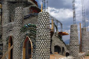
The 2007 film Garbage Warrior documents architect Mike Reynolds who builds Earthships in and around Taos County.[15]
انظر أيضاً
المراجع
- ^ أ ب "State & County QuickFacts". United States Census Bureau. Retrieved September 30, 2013.
- ^ "Find a County". National Association of Counties. Retrieved June 7, 2011.
- ^ "New Mexico: Consolidated Chronology of State and County Boundaries". New Mexico Atlas of Historical County Boundaries. The Newberry Library. 2007. Archived from the original on August 22, 2016. Retrieved January 2, 2015.
- ^ "2010 Census Gazetteer Files". United States Census Bureau. أغسطس 22, 2012. Archived from the original on يناير 1, 2015. Retrieved يناير 2, 2015.
- ^ Carl Mills. "Mean County Elevation Lists". Retrieved October 19, 2014.
- ^ "Population and Housing Unit Estimates". Retrieved December 23, 2019.
- ^ "U.S. Decennial Census". United States Census Bureau. Retrieved January 2, 2015.
- ^ "Historical Census Browser". University of Virginia Library. Retrieved January 2, 2015.
- ^ "Population of Counties by Decennial Census: 1900 to 1990". United States Census Bureau. Retrieved January 2, 2015.
- ^ "Census 2000 PHC-T-4. Ranking Tables for Counties: 1990 and 2000" (PDF). United States Census Bureau. Retrieved January 2, 2015.
- ^ Leip, David. "Dave Leip's Atlas of U.S. Presidential Elections". uselectionatlas.org. Retrieved 2018-04-02.
- ^ "Rio Grande Gorge Bridge". New York Times. 2011. Retrieved 2011-06-04.
- ^ "Goofs for Wild Hogs (2007)". IMDb. Retrieved 2011-06-04.
- ^ "Terminator Salvation: Set Locations Revisited". TheTerminatorFans.com. 2010-01-28. Retrieved 2011-06-03.
- ^ "Garbage Warrior". HESO Magazine. October 7, 2009.
وصلات خارجية

|
Costilla County, Colorado | Conejos County, Colorado | 
| |
| Colfax County | Rio Arriba County | |||
| Mora County | Rio Arriba County |
- Pages using gadget WikiMiniAtlas
- Short description is different from Wikidata
- Coordinates on Wikidata
- مقاطعات New Mexico
- Articles containing إنگليزية-language text
- Pages using Lang-xx templates
- Pages using US Census population needing update
- مقاطعة تاوس، نيومكسيكو
- تأسيسات 1852 في إقليم نيومكسيكو
- أماكن مأهولة تأسست في 1852
- مقاطعات نيومكسيكو


