الحدود الاسكتلندية
Scottish Borders The Mairches Crìochan na h-Alba | |
|---|---|
 | |
| الإحداثيات: 55°21′36″N 2°29′24″W / 55.36000°N 2.49000°W | |
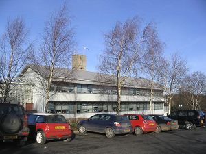
| Admin HQ | Newtown St Boswells |
| الحكومة | |
| • الكيان | Scottish Borders Council |
| • Control | Con + Ind (council NOC) |
| • MPs |
|
| • MSPs | |
| ترتيب المساحة | Ranked |
| • الترتيب | Ranked |
| ONS code | S12000026 |
| ISO 3166 code | GB-SCB |
| الموقع الإلكتروني | www |
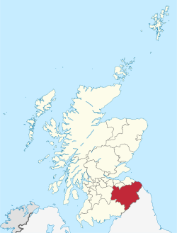
الحدود الاسكتلندية (Scottish Borders ؛ سكوتس: the Mairches, lit. 'التخوم'؛ غالية اسكتلندية: Crìochan na h-Alba) هي واحدة من 32 منطقة مجالس في اسكتلندا.[1] وهي تحد مدينة إدنبره، دمفريز وگالوي، شرق لوثيان، ميدلوثيان، جنوب لاناركشاير, غرب لوثيان وإلى الجنوب الغربي والجنوب والشرق، المقاطعات الإنگليزية كمبريا ونورثمبرلاند. المركز الاداري للمنطقة هو Newtown St Boswells.
المصطلح "الحدود الاسكتلندية" يُستخدم أيضاً لوصف مناطق جنوب اسكتلندا وشمال إنگلترة التي تحف الحدود الاسكتلندية الإنگليزية.
الجغرافيا
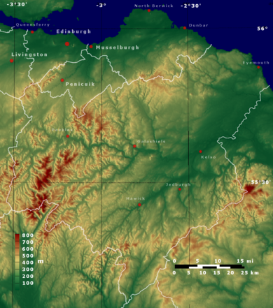
تقع الحدود الاسكتلندية في الجزء الشرقي من Southern Uplands.[2]
The region is hilly and largely rural, with the River Tweed flowing west to east through it. The highest hill in the region is Broad Law in the Manor Hills. In the east of the region, the area that borders the River Tweed is flat and is known as 'The Merse'.[3] The Tweed and its tributaries drain the entire region with the river flowing into the North Sea at Berwick-upon-Tweed, and forming the border with England for the last twenty miles or so of its length.
The term Central Borders refers to the area in which the majority of the main towns of Galashiels, Selkirk, Hawick, Jedburgh, Earlston, Kelso, Newtown St. Boswells, St Boswells, Peebles, Melrose and Tweedbank are located.
Two of Scotland's 40 national scenic areas (defined so as to identify areas of exceptional scenery and to ensure their protection from inappropriate development)[4] lie within the region:[5]
- The Eildon and Leaderfoot National Scenic Area covers the scenery surrounding Eildon Hill, and extends to include the town of Melrose and Leaderfoot Viaduct.[6]
- The Upper Tweeddale National Scenic Area covers the scenery surrounding the upper part of the River Tweed between Broughton and Peebles.[7]
أكبر البلدات
2011[8]
- Galashiels: 14,994
- Hawick: 14,294
- Peebles: 8,376
- Selkirk: 5,784
- Kelso: 5,639
- Jedburgh: 4,030
- Eyemouth: 3,546
- Innerleithen: 3,031
- Duns: 2,753
- Melrose: 2,307
- Coldstream: 1,946
- Earlston: 1,779
التاريخ
The term Borders also has a wider meaning, referring to all of the counties adjoining the English border, also including Dumfriesshire and Kirkcudbrightshire – as well as Northumberland, Cumberland and Westmorland في إنگلترة.
Roxburghshire and Berwickshire historically bore the brunt of the conflicts with England, both during declared wars such as the Wars of Scottish Independence, and armed raids which took place in the times of the Border Reivers. Thus, across the region are to be seen the ruins of many castles, abbeys and even towns.
The council area was created in 1975, by merging the historic counties of Berwickshire, Peeblesshire, Roxburghshire, and Selkirkshire and part of Midlothian, as a two-tier region with the districts of Berwickshire, Ettrick and Lauderdale, Roxburgh, and Tweeddale within it. In 1996 the region became a unitary authority area and the districts were wound up. The region was created with the name Borders. Following the election of a shadow area council in 1995 the name was changed to Scottish Borders with effect from 1996.[9]
Although there is evidence of some Scottish Gaelic in the origins of place names such as Innerleithen ("confluence of the Leithen"), Kilbucho and Longformacus, which contain identifiably Goidelic rather than Brythonic Celtic elements and are an indication of at least a Gaelic-speaking elite in the area, the main languages in the area since the 5th century appear to have been Brythonic (in the west) and Old English (in the east), the latter of which developed into its modern forms of English and Scots.
السياسة
There are two British Parliamentary constituencies in the Borders. Berwickshire, Roxburgh and Selkirk covers most of the region and is represented by John Lamont of the Conservatives. The western Tweeddale area is included in the Dumfriesshire, Clydesdale & Tweeddale constituency and is represented by David Mundell of the Conservatives.
At Scottish Parliament level, there are also two seats. The eastern constituency is Ettrick, Roxburgh and Berwickshire, which is currently represented by Conservative Rachael Hamilton. The western constituency is Midlothian South, Tweeddale and Lauderdale and is represented by SNP Christine Grahame.
Following the 2012 local elections, the council administration was a coalition of Independents, Scottish National Party and Liberal Democrats. Prior to the election a coalition of Conservatives, Liberal Democrats and Independents ruled. The Conservatives were the biggest party on the council with 10 seats, the Liberal Democrats had six. The SNP had nine seats and the Independents had seven. Two councillors form the Borders Party.
Following the 2017 local elections, the council is now a coalition of Independents and Conservatives. The Conservatives became the largest party on the council with 15, an increase of 5.
| الحزب | المقاعد | |
|---|---|---|
| المحافظون | 15 | |
| الحزب الوطني الاسكتلندي | 9 | |
| Independent | 8 | |
| Liberal Democrats | 2 | |
التعداد
At the Census held on 27 March 2011, the population of the region was 114,000 (provisional total), an increase of 6.78% from the 106,764 enumerated at the previous (2001) Census.
النقل
The region had until September 2015 no working railway stations. Although the area was well connected to the Victorian railway system, the branch lines that supplied it were closed in the decades following the Second World War. A bill was passed by the Scottish Parliament to extend the Waverley Line, which aimed to re-introduce a commuter service from Edinburgh to Stow, Galashiels and Tweedbank. This section of the route re-opened on 6 September 2015, under the Borders Railway branding. The other railway route running through the region is the East Coast Main Line, with Edinburgh Waverley, Dunbar and Berwick being the nearest stations on that line, all of which are outwith the Borders. Since 2014 there has been discussion[10] of re-opening the station at Reston which is within the region and would serve Eyemouth. To the west, Carlisle, Carstairs and Lockerbie are the nearest stations on the West Coast Main Line.
The area is served by buses which connect the main population centres. Express bus services link the main towns with rail stations at Edinburgh and Carlisle.
The region also has no commercial airports; the nearest are Edinburgh and Newcastle, both of which are international airports.
The main roads to and from the region are:
- The A1, which runs along the east coast from London to Edinburgh; passing near Eyemouth.
- The A7 which runs north to south from Edinburgh to Carlisle and the M6; passing through Galashiels, Selkirk and Hawick.
- The A68 running from Darlington to Edinburgh; passing through Jedburgh, St. Boswells, Earlston and Lauder.
- The A72, which runs east to west from Galashiels to Hamilton; passing through Innerleithen and Peebles
بلدات وقرى

- Abbey St. Bathans, Allanton, Ancrum, Ashkirk, Ayton
- Broughton, Burnmouth
- Camptown, Cardrona, Chirnside, Clovenfords, Cockburnspath, Coldingham, Coldstream
- Denholm, Dryburgh, Duns
- Earlston, Edgerston, Edrom, Eddleston, Ettrick, Ettrickbridge, Eyemouth
- Foulden
- Galashiels, Grantshouse, Greenlaw
- Hawick, Heriot, Hutton
- Innerleithen
- Jedburgh
- Kelso, Kirk Yetholm
- Lauder, Lilliesleaf, Longformacus
- Melrose, Morebattle
- Newcastleton, Newstead, Newtown St Boswells
- Oxton
- Peebles, Preston, Paxton
- Reston, Roxburgh
- Selkirk, St. Abbs, St Boswells, Stow, Stichill, Swinside, Swinton
- Teviothead, Town Yetholm, Traquair, Tweedbank, Tweedsmuir
- Walkerburn, West Linton, Whitsome
- Yair
معالم
- Abbotsford House
- Berwickshire Coastal Path
- Bowhill House
- Cheviot Hills
- Cessford Burn
- Coldingham Bay
- Dawyck Botanic Garden
- Dryburgh Abbey – اسكتلندة التاريخية
- Duns Castle
- Edin's Hall Broch
- Ettrick Forest
- Eyemouth
- Floors Castle
- Glentress Forest – Forest Enterprise
- Greenknowe Tower
- Harmony Garden – National Trust for Scotland
- Hawkshaw – ancestral home of the Porteous family
- Hermitage Castle – اسكتلندة التاريخية
- Jedburgh Abbey – اسكتلندة التاريخية
- Kailzie Gardens
- Kelso Abbey
- Kirna House (The Kirna)
- Lammermuir Hills
- Lauderdale
- Manderston
- Megget Reservoir
- Mellerstain House
- Melrose Abbey – اسكتلندة التاريخية
- Mire Loch
- Monteviot
- Morebattle
- Neidpath Castle
- Nisbet, Berwickshire
- Nisbet, Roxburghshire
- Paxton House
- Pennine Way – National Trails
- Priorwood Garden – National Trust for Scotland
- Robert Smail's Printing Works – National Trust for Scotland
- Scots' dike
- Smailholm Tower – اسكتلندة التاريخية
- Southern Upland Way – National Trails
- St. Abbs Head
- St. Mary's Loch
- St. Ronans Wells
- Teviotdale
- Thirlestane Castle
- Traquair House
- Trimontium
- Union Bridge
- Waterloo Monument
- Wedderburn Castle
انظر أيضاً
- Borders College
- Scottish Marches
- Anglo-Scottish border
- Debatable lands
- List of places in the Scottish Borders
- Scottish Lowlands
- Alexander Jeffrey, historian of Scottish Borders
ملاحظات ومراجع
- ^ Foundation, Internet Memory. "[Archived Content] UK Government Web Archive – The National Archives". Archived from the original on 5 فبراير 2008.
{{cite web}}: CS1 maint: bot: original URL status unknown (link) - ^ "Accommodation – Dumfries and Galloway – Ayrshire and Arran – Scottish Borders – Southern South West Scotland – Hotels – Bed and Breakfasts – Self Catering Holiday Cottages".
- ^ p. 47 ofBanks, F. R. (Francis Richard) (1951), Scottish Border Country, Batsford, http://trove.nla.gov.au/work/10125169, retrieved on 20 October 2016
- ^ "National Scenic Areas". Scottish Natural Heritage. Retrieved 5 يوليو 2018.
- ^ "National Scenic Areas – Maps". SNH. 20 ديسمبر 2010. Retrieved 7 مارس 2018.
- ^ "Eildon and Leaderfoot National Scenic Area Map" (PDF). Scottish Natural Heritage. 20 ديسمبر 2010. Retrieved 3 مارس 2018.
- ^ "Upper Tweeddale NSA Map" (PDF). Scottish Natural Heritage. Retrieved 3 يوليو 2018.
- ^ http://www.ourscottishborders.com/live/towns/populations
- ^ Notice of change of name of local authority area, Edinburgh Gazette, 26 May 1995
- ^ Rinaldi, Giancarlo (18 مارس 2016). "Borders Railway future goals drawn up". BBC News.
وصلات خارجية
- Pages using gadget WikiMiniAtlas
- CS1 maint: bot: original URL status unknown
- Articles with hatnote templates targeting a nonexistent page
- Missing redirects
- Use dmy dates from July 2014
- Use British English from July 2014
- Short description matches Wikidata
- Short description is different from Wikidata
- Articles containing سكوتس-language text
- Articles containing غالية اسكتلندية-language text
- Coordinates on Wikidata
- Pages using infobox settlement with missing country
- Pages using infobox settlement with no map
- Pages using Lang-xx templates
- الحدود الاسكتلندية
- مناطق مجالس اسكتلندا
- مناطق اسكتلندا
- نورثمبريا
- Southern Uplands
