أندوڤر، هامپشر
| أندوڤر | |
|---|---|
 High Street | |
Location within Hampshire | |
| Population | 38٬290 (2011 Census)[1] (50,000 as to built-up area in 2020)[2] |
| OS grid reference | SU3646 |
| Civil parish |
|
| District | |
| Shire county | |
| Region | |
| Country | England |
| Sovereign state | United Kingdom |
| Post town | Andover |
| Postcode district | SP10, SP11 |
| Dialling code | 01264 |
| Police | Hampshire |
| Fire | Hampshire |
| Ambulance | South Central |
| EU Parliament | South East England |
| UK Parliament | |
| Website | Town Council |
أندوڤر (Andover ؛ /ˈændoʊvər/ AN-doh-vər) هي بلدة في مقاطعة هامپشر الإنگليزية. وتطل البلدة على نهر أنطون، أحد المصادر الرئيسية لنهر تست، على بعد 29 كم غرب بلدة بيزنگستوك، وكلاهما محطات قطارات رئيسية. وهي 32 كم شمال بشمال غرب مدينة ونشستر، 56 كم شمال مدينة ساوثهامپتون و 105 كم غرب بجنوب غرب لندن.[3] أندوڤر متوأمة مع بلدات ريدون في فرنسا،[4] گوخ في ألمانيا، و أندوڤر، مساتشوستس في الولايات المتحدة.[5][6]
التاريخ
التاريخ المبكر
اسم البلدة مسجل بالإنگليزية القديمة في 955 كالتالي Andeferas، ويـُعتقـَد أنها ذات أصل كلتي: قارن الويلزية onn dwfr = "ash(tree) water".
الطواحين والمطاحن

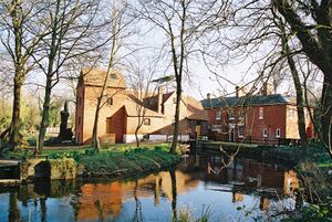
Watermills have formed an important part in Andover's history. The Domesday Book of 1086 provides the earliest record of watermills in Andover, which identifies six mills.[7]

المناخ
Andover, in common with much of the UK, experiences a maritime climate type, reflected in its limited temperature range and lack of rainy/dry seasons, although rainfall does tend to peak in winter and reach a minimum in summer. The nearest met office weather station to Andover is Leckford, about 5 ميل (8 km) south of the town centre.
The absolute maximum temperature recorded was 34.7 °C (94.5 °F)[8] during August 1990. In an average year the hottest day will achieve a temperature of 29.0 °C (84.2 °F).[9] In total 12.8 days[9] should have a maximum temperature of 25.1 °C (77.2 °F) or above.
The absolute minimum temperature recorded was −15.6 °C (3.9 °F)[10] during December 1960. In an average year the coldest night will fall to −7.5 °C (18.5 °F).[11] In total 46.6 nights[12] should register an air frost.
Total rainfall averages 805 mm[13] per year, with at least 1 mm falling on 124 days.[14] All averages refer to the 1971–2000 observation period.
| بيانات المناخ لـ لكفورد، منسوب 117م، 1971–2000، القصوى 1960–2007 | |||||||||||||
|---|---|---|---|---|---|---|---|---|---|---|---|---|---|
| الشهر | ينا | فب | مار | أبر | ماي | يون | يول | أغس | سبت | أكت | نوف | ديس | السنة |
| القصوى القياسية °س (°ف) | 13.5 (56.3) |
15.4 (59.7) |
20.0 (68.0) |
25.3 (77.5) |
27.2 (81.0) |
33.5 (92.3) |
33.8 (92.8) |
34.7 (94.5) |
28.9 (84.0) |
24.0 (75.2) |
17.0 (62.6) |
14.9 (58.8) |
34.7 (94.5) |
| متوسط القصوى اليومية °س (°ف) | 7.0 (44.6) |
7.3 (45.1) |
9.9 (49.8) |
12.6 (54.7) |
16.3 (61.3) |
18.9 (66.0) |
21.8 (71.2) |
21.8 (71.2) |
18.3 (64.9) |
14.0 (57.2) |
9.9 (49.8) |
7.8 (46.0) |
13.8 (56.8) |
| متوسط الدنيا اليومية °س (°ف) | 1.2 (34.2) |
1.0 (33.8) |
2.6 (36.7) |
3.7 (38.7) |
6.5 (43.7) |
9.1 (48.4) |
11.3 (52.3) |
11.4 (52.5) |
9.5 (49.1) |
6.9 (44.4) |
3.7 (38.7) |
2.2 (36.0) |
5.8 (42.4) |
| الصغرى القياسية °س (°ف) | −13.9 (7.0) |
−10.5 (13.1) |
−8.3 (17.1) |
−5.6 (21.9) |
−2.2 (28.0) |
0.6 (33.1) |
3.3 (37.9) |
4.4 (39.9) |
1.0 (33.8) |
−3.1 (26.4) |
−7.5 (18.5) |
−15.6 (3.9) |
−15.6 (3.9) |
| متوسط تساقط الأمطار mm (inches) | 88.07 (3.47) |
58.81 (2.32) |
63.31 (2.49) |
51.93 (2.04) |
50.85 (2.00) |
59.27 (2.33) |
42.57 (1.68) |
59.22 (2.33) |
69.60 (2.74) |
84.06 (3.31) |
82.12 (3.23) |
94.9 (3.74) |
804.71 (31.68) |
| Source: KNMI[15] | |||||||||||||
انظر أيضاً
- Amport House
- Andover workhouse scandal
- The Angel Inn - a 15th-century medieval coaching inn and the oldest building in Andover
- Army Air Corps
- Caldera UK (1996-1999), developers of OpenDOS/DR-DOS and WebSpyder
الهامش
- ^ قالب:NOMIS
- ^ "Andover Town Centre Masterplan" (PDF). Retrieved 23 September 2020.
- ^ Ordnance Survey (2004). OS Explorer Map 131 – Romsey, Andover & Test Valley. ISBN 0-319-23600-5.
- ^ "British towns twinned with French towns". Archant Community Media Ltd. Archived from the original on 5 July 2013. Retrieved 11 July 2013.
- ^ "Andover Town Twinning". Andover Town Twinning Association. Archived from the original on 13 November 2010. Retrieved 19 April 2011.
- ^ "Andover, Hampshire, England twinning". Andover MA Town Council. Archived from the original on 5 مايو 2011. Retrieved 19 أبريل 2011.
- ^ خطأ استشهاد: وسم
<ref>غير صحيح؛ لا نص تم توفيره للمراجع المسماةTim Lambert - ^ "1990 maximum". Retrieved 3 March 2011.
- ^ أ ب "1971-00 Days >25c". Retrieved 3 March 2011.
- ^ "1960 minimum". Retrieved 3 March 2011.
- ^ "1971-00 average coldest night". Retrieved 3 March 2011.
- ^ "1971-00 average frosts". Retrieved 3 March 2011.
- ^ "1971-00 Rainfall". Retrieved 3 March 2011.
- ^ "1971-00 Raindays". Retrieved 3 March 2011.
- ^ "Climate Normals 1971–2000". KNMI. Retrieved 3 March 2011.
