الطابغة
الطابغة | |
|---|---|
قرية | |
 Tabgha in 1903 | |
| أصل الاسم: From the Greek name "Heptapegon", lit. "seven springs". | |
 الطابغة | |
| الإحداثيات: 32°52′20″N 35°33′00″E / 32.87222°N 35.55000°ECoordinates: 32°52′20″N 35°33′00″E / 32.87222°N 35.55000°E | |
| Palestine grid | 201/252 |
| Geopolitical entity | Mandatory Palestine |
| Subdistrict | Tiberias |
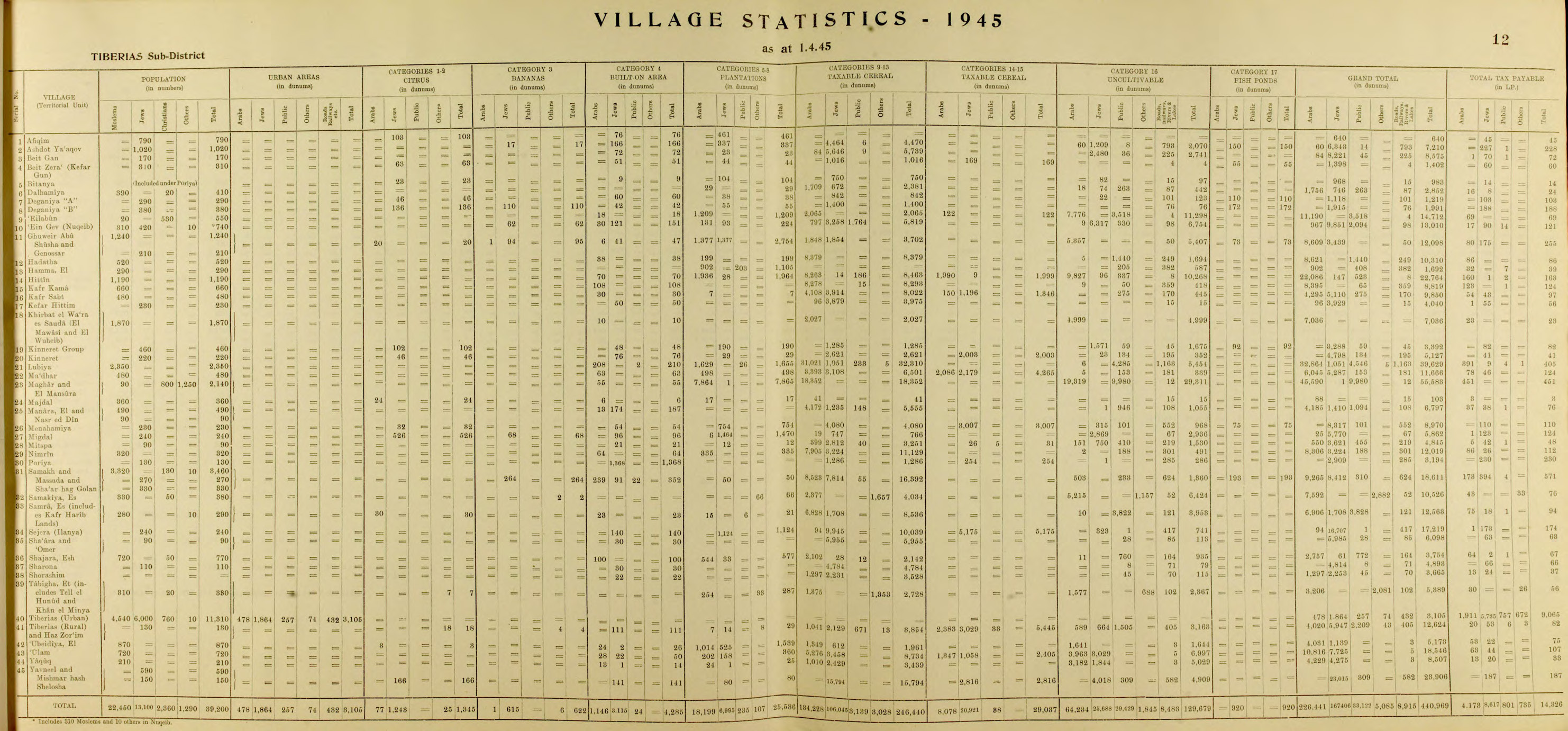
| المساحة | |
| • الإجمالي | 5 389 (includes Tell el Hunud and Khan el Minya dunams (خطأ في التعبير: رقم غير متوقع. ha or خطأ في التعبير: رقم غير متوقع. acres) |
| التعداد (1945) | |
| • الإجمالي | 330[1][2] |


قرية الطابغة ( وتعني الينابيع السبعة باللغة اليونانية ) تقع على الشاطئ الشمالي لبحيرة طبريا على الحدود إسرائيلية – السورية، وتبلغ مساحة أراضيها 5389.وتحيط بها أراضي قرى السميكة والقديرية وغور أبو شوشة ومياه بحيرة طبريا، أما عدد سكانها فقد ارتفع من 175 نسمة في عام 1922 إلى 310 نسمة في عام 1945 والى 2531 نسمة في عام 1998 حسب إحصائيات سلطات الاحتلال وكلهم فلسطينيون ، ومن معالمها خان منيا الذي يقع جنوب تل حوم عند مصب نهر الأردن في بحيرة طبريا في مكان بلدة جنسار الكنعانية ويحتوي على بقايا خان وقصر الخليفة الأموي عبد الملك بن مروان الشتوي وخربة العريمة التي تنخفض 125 مترا تحت مستوى سطح البحر وتحتوي على آثار بلدة كنار الكنعانية وجدران وأساسات ومجرى منقور في الصخر، وقد دمرها الغزاة الصهاينة وشتتوا أهلها في 1/5/1948 وأقاموا على أنقاضها مستعمرة تيفيريا.
. . . . . . . . . . . . . . . . . . . . . . . . . . . . . . . . . . . . . . . . . . . . . . . . . . . . . . . . . . . . . . . . . . . . . . . . . . . . . . . . . . . . . . . . . . . . . . . . . . . . . . . . . . . . . . . . . . . . . . . . . . . . . . . . . . . . . . . . . . . . . . . . . . . . . . . . . . . . . . . . . . . . . . . .
Church of the Multiplication
The earliest building at Tabgha was a small chapel built in the 4th century A.D. (around 350) by the Jewish convert to Christianity, Joseph of Tiberias. According to Epiphanius, Joseph was a contemporary of Emperor Constantine, a Rabbinical scholar, member of the Sanhedrin and a disciple of Hillel II. Following his conversion, Emperor Constantine gave him the rank of count (comes), and gave him permission to build churches in the Galilee, specifically, in Jewish towns which didn't yet have a Christian community, and the Galilee including the Sea of Galilee, was an area with a Jewish majority. This was probably the shrine described by the pilgrim Egeria at the end of the 4th century. The 4th century small shrine was dismounted in 480 and a bigger chapel was built by Martyrius of Jerusalem, Patriarch of Jerusalem from 478 to 486. Martyrius was Egyptian by origin, and this may be the reason why the floor of his chapel was covered with a beautiful Nile mosaic, a style of art popular in the Byzantine time, describing Nilotic landscape and the fest of the Nile.[بحاجة لمصدر]

انظر أيضاً
- خربة المنيا - أطلال قصر أموي
- Kinneret (archaeological site) - biblical city which gave the Sea of Galilee its Hebrew name; now Tell el-'Oreimeh (Arabic) or Tel Kinrot (Hebrew)
- Sea of Galilee Boat - fishing boat from the 1st century CE, preserved in a museum at Kibbutz Ginosar
المراجع
ببليوگرافيا
- Barron, J.B., ed. (1923). Palestine: Report and General Abstracts of the Census of 1922. Government of Palestine.
- Burckhardt, J.L. (1822). Travels in Syria and the Holy Land. London: J. Murray.
- Conder, C.R.; Kitchener, H.H. (1881). The Survey of Western Palestine: Memoirs of the Topography, Orography, Hydrography, and Archaeology. Vol. 1. London: Committee of the Palestine Exploration Fund.
- Government of Palestine, Department of Statistics (1945). Village Statistics, April, 1945.
- Guérin, V. (1880). Description Géographique Historique et Archéologique de la Palestine (in French). Vol. 3: Galilee, pt. 1. Paris: L'Imprimerie Nationale.
{{cite book}}: CS1 maint: unrecognized language (link) (pp. 224-226) - Hadawi, S. (1970). Village Statistics of 1945: A Classification of Land and Area ownership in Palestine. Palestine Liberation Organization Research Center.
- Hütteroth, Wolf-Dieter; Abdulfattah, Kamal (1977). Historical Geography of Palestine, Transjordan and Southern Syria in the Late 16th Century. Erlanger Geographische Arbeiten, Sonderband 5. Erlangen, Germany: Vorstand der Fränkischen Geographischen Gesellschaft. ISBN 3-920405-41-2.
- Karmon, Y. (1960). "An Analysis of Jacotin's Map of Palestine" (PDF). Israel Exploration Journal. 10 (3, 4): 155–173, 244–253.
- Khalidi, W (1992). All That Remains: The Palestinian Villages Occupied and Depopulated by Israel in 1948. Washington D.C.: Institute for Palestine Studies. ISBN 0-88728-224-5.
- Mills, E., ed. (1932). Census of Palestine 1931. Population of Villages, Towns and Administrative Areas. Jerusalem: Government of Palestine.
- Morris, B. (2004). The Birth of the Palestinian Refugee Problem Revisited. Cambridge University Press. ISBN 978-0-521-00967-6.
- Oliphant, L. (1887). Haifa, or Life in Modern Palestine. Edinburgh: Blackwood. (Oliphant, 1887, p. 227; cited in Khalidi, 1992, p. 542)
- Palmer, E.H. (1881). The Survey of Western Palestine: Arabic and English Name Lists Collected During the Survey by Lieutenants Conder and Kitchener, R. E. Transliterated and Explained by E.H. Palmer. Committee of the Palestine Exploration Fund.
- Pringle, Denys (1998). The Churches of the Crusader Kingdom of Jerusalem: L-Z (excluding Tyre). Vol. II. Cambridge University Press. ISBN 0 521 39037 0.
- Rhode, H. (1979). Administration and Population of the Sancak of Safed in the Sixteenth Century. Columbia University.
- Robinson, E.; Smith, E. (1841). Biblical Researches in Palestine, Mount Sinai and Arabia Petraea: A Journal of Travels in the year 1838. Vol. 3. Boston: Crocker & Brewster.
. . . . . . . . . . . . . . . . . . . . . . . . . . . . . . . . . . . . . . . . . . . . . . . . . . . . . . . . . . . . . . . . . . . . . . . . . . . . . . . . . . . . . . . . . . . . . . . . . . . . . . . . . . . . . . . . . . . . . . . . . . . . . . . . . . . . . . . . . . . . . . . . . . . . . . . . . . . . . . . . . . . . . . . .
وصلات خارجية
- Welcome To al-Tabigha
- al-Tabigha, Zochrot
- Survey of Western Palestine, Map 6: IAA, Wikimedia commons
| الأشخاص |
|  | |||||||||||||||||||||||||||||||
|---|---|---|---|---|---|---|---|---|---|---|---|---|---|---|---|---|---|---|---|---|---|---|---|---|---|---|---|---|---|---|---|---|---|
| القوات المتحاربة |
| ||||||||||||||||||||||||||||||||
| المعارك | |||||||||||||||||||||||||||||||||
| أماكن | |||||||||||||||||||||||||||||||||
| قرارات واتفاقيات |
| ||||||||||||||||||||||||||||||||
| التبعات |
| ||||||||||||||||||||||||||||||||
- Short description is different from Wikidata
- Coordinates on Wikidata
- Articles with hatnote templates targeting a nonexistent page
- Articles with unsourced statements from November 2014
- قرى عربية فلسطينية أخليت أثناء حرب 1948
- قضاء طبريا
- أماكن مذكورة في الإنجيل
- تاريخ إسرائيل حسب الموقع
- مستوطنات يهودية قديمة في منطقة الجليل
- مواقع أثرية في إسرائيل
- معالم الجليل