محافظة سييم رياب
| ||||||||||||||||||||||||||||||||||||||||||||||||||||||


.jpg&filetimestamp=20240301054206&)


Siem Reap, officially Siemreap[3] (خمير وسطى: សៀមរាប [siəm riəp], حرفياً 'Siam's Defeated'), is a province (khaet) of Cambodia. It borders the provinces of Oddar Meanchey to the north, Preah Vihear and Kampong Thom to the east, Battambang to the south, and Banteay Meanchey to the west. Its capital and largest city is Siem Reap.
Siem Reap province is the tenth largest province in Cambodia. Having reached a population of one million in 2019, it ranks as the nation's fourth most populous province.[2] A large portion of Siem Reap province's southern border is demarcated by the Tonle Sap and as such, it is one of the nine provinces that making up the Tonle Sap Biosphere Reserve. In modern times the province is best known as the site of Angkor and the Angkor Wat temple ruins, a UNESCO World Heritage Site. It is also the home of Banteay Srei, Roluos (temples), the UNESCO tentative site of Beng Mealea, and the UNESCO tentative site of Phnom Kulen National Park, home to the country's largest reclining Buddha.
أصل الاسم
The name Siem Reap literally means 'Siam defeated', a reminder of the centuries-old conflict between the Siamese and the Khmer. In Siam, the province and its capital were called Siemmarat (بالتايلندية: เสียมราฐ), literally meaning 'Siam's territory'.[4]
التاريخ
The province came under the control of the Thai kingdom of Siam in 1795 and was later returned to Cambodia in 1907 after the French made a treaty with Siam for the exchange of Trat and Dan Sai for the Siamese province of Inner Cambodia which included Phra Tabong (Battambang), Siemmarat (Siem Reap), and Nakhon Wat (Angkor Wat). The Inner Cambodia province was split into Battambang and Siem Reap by the royal decree of King Sisowath the same year. This area became part of a disputed territory between France and Siam (now Thailand) which led to the Franco-Thai War in 1941, resulting in victory for Thailand and a return to Thai control (with exception of Siem Reap and Angkor Wat). The province again reverted to Cambodia in 1946, after the end of World War II with French and UN international pressure.
الدين
Religion in Siem Reap province (2019 census)[5]
The state religion is Theravada Buddhism. More than 99.3% of the people in Siem Reap province are Buddhists. About 0.4% population of Siem Reap province follow Christianity. Islam which is mostly followed by Chams is 0.2% in the province.
التقسيمات
The province is divided into 1 municipality and 11 districts, and further subdivided into 100 communes and 907 villages.[6]
| ISO code |
Name | Khmer | Subdivisions | ||
|---|---|---|---|---|---|
| — Municipality — | |||||
| 17-10 | Siem Reap | សៀមរាប | 12 sangkat | ||
| — District — | |||||
| 17-01 | Angkor Chum | អង្គរជុំ | 7 khum | ||
| 17-02 | Angkor Thom | អង្គរធំ | 4 khum | ||
| 17-03 | Banteay Srei | បន្ទាយស្រី | 6 khum | ||
| 17-04 | Chi Kraeng | ជីក្រែង | 12 khum | ||
| 17-06 | Kralanh | ក្រឡាញ់ | 10 khum | ||
| 17-07 | Puok | ពួក | 14 khum | ||
| 17-09 | Prasat Bakong | ប្រាសាទបាគង | 9 khum | ||
| 17-11 | Soutr Nikom | សូត្រនិគម | 10 khum | ||
| 17-12 | Srei Snam | ស្រីស្នម | 6 khum | ||
| 17-13 | Svay Leu | ស្វាយលើ | 5 khum | ||
| 17-14 | Varin | វ៉ារិន | 5 khum | ||
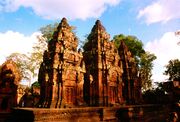
Gallery
-
-
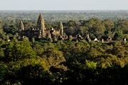 Angkor Wat view from Phnom Bakheng
 -
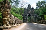 South gate of Angkor Thom
 -
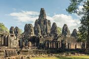 Bayon Temple
 -


References
- ^ "History of Siem Reap". siemreap.gov.kh. Archived from the original on 18 July 2019. Retrieved 17 August 2019.
- ^ أ ب "General Population Census of the Kingdom of Cambodia 2019 – Final Results" (PDF). National Institute of Statistics. Ministry of Planning. 26 January 2021. Retrieved 3 February 2021.
- ^ "Geographical Names of the Kingdom of Cambodia" (PDF). UNSTATS. Eighth United Nations Conference on the Standardization of Geographical Names. 29 August 2002. Retrieved 7 June 2019.
- ^ Article 6 of the "Convention between France and Siam Amending the Stipulations of the Treaty of 8 October 1904, Concerning the Territories and the Other Arrangements, Signed at Paris, the 13th February 1904."
- ^ "General Population census of the Kingdom of Cambodia 2019" (PDF). National Institute of Statistics Ministry of planning. October 2020.
- ^ "Administration; Siem Reap". Kingdom of Cambodia. Archived from the original on 27 مايو 2009. Retrieved 27 يونيو 2010.
وصلات خارجية
- Official website
- Siem Reap - The Gate to Angkor (Official Website of the Provincial Town Siem Reap on www.rithyrineangkorresidence.com
أماكن قريبة من محافظة سييم رياب | |
|---|---|
| البلدية الذاتية | ||
|---|---|---|
| المحافظات | ||
| Authority control databases: National |
|---|