مناطق نيوزيلندا
(تم التحويل من Regions of New Zealand)
| نيوزيلندا | |
 هذه المقالة هي جزء من سلسلة: | |
|
| |
|
عام
| |
|
دول أخرى • أطلس بوابة السياسة | |


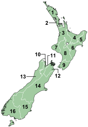
The region is the top tier of local government in New Zealand. There are 16 regions of New Zealand. Eleven are governed by an elected regional council, while five are governed by territorial authorities (the second tier of local government) which also perform the functions of a regional council and thus are known as unitary authorities. The Chatham Islands Council is similar to a unitary authority, but is authorised under its own enabling legislation.[1]
قائمة المناطق
List of United Councils
| Region | United Council formed | Rates Levy (1982/83) |
|---|---|---|
| Northland | January 1980 | $118,000 |
| Thames Valley | July 1980 | $46,000 |
| وايكاتو | October 1980 | $36,000 |
| Bay of Plenty | August 1979 | $17,000 |
| Tongariro | November 1979 | $50,000 |
| East Cape | August 1979 | $16,000 |
| Hawkes Bay | December 1983 | – |
| Taranaki | February 1979 | $60,000 |
| Wanganui | May 1979 | $81,000 |
| Wairarapa | November 1978 | $33,000 |
| Manawatu | May 1981 | 0 |
| Horowhenua | June 1980 | $47,000 |
| Nelson Bays | November 1978 | $84,000 |
| Marlborough | December 1978 | $30,000 |
| كانتربري | May 1979 | $605,000 |
| West Coast | November 1978 | $32,000 |
| Aorangi | 1983 | – |
| Coastal / North Otago | April 1983 | – |
| Clutha / Central Otago | November 1980 | $33,000 |
| ساوثلاند | May 1979 | $88,000 |
Source: Summary of the Functions and Activities of United Councils Dept of Internal Affairs, 1984.
انظر أيضا
- Provinces of New Zealand
- Territorial authorities of New Zealand
- Local Government New Zealand
- List of towns in New Zealand
الهامش
- ^ Chatham Islands Council Act 1995, Parliament of New Zealand, 1995, Statute No 041, Commenced: 1 November 1995, retrieved 4 February 2008.
- ^ Living Density: Table 1, Housing Statistics, Statistics New Zealand. Accessed 25 January 2009. Areas are based on 2001 boundaries. Water bodies greater than 15 hectares are excluded.
- ^ "Subnational population estimates at 30 June 2011 (boundaries at 1 July 2011)". Statistics New Zealand. 19 December 2011. Retrieved 19 December 2011.
| North Island | ||
|---|---|---|
| South Island | ||
* Governed by a unitary authority rather than a regional council | ||
| التقسيمات الادارية في نيوزيلندا | |||||||||||
|---|---|---|---|---|---|---|---|---|---|---|---|
| أملاك الكومنولث | عموم نيوزيلندا | ||||||||||
| الأقاليم والمناطق التابعة | نيوزيلندا | Ross Dependency | توكلاو | جزر كوك | نيوي | ||||||
| المناطق | 11 non-unitary regions | 5 unitary regions | Chatham Islands | الجزر النائية خارج أي سلطة مناطقية (جزر كرمادك، جزر الملوك الثلاث, and sub-Antarctic islands) | |||||||
| السلطات الإقليمية | 13 cities and 53 districts | ||||||||||
| هوامش | بعض المقاطعات تقع في أكثر من منطقة | These combine the regional and the territorial authority levels in one | السلطة الإقليمية الخاصة | جزر سولاندر النائية تشكل جزءا من منطقة ساوثلاند | New Zealand's الأراضي الأنتارتيكية | Non-self-governing territory لنيوزيلندا | دول في ارتباط حر مع نيوزيلندا | ||||