_were_razed_to_make_way_for_the_new_quay.jpg)
_were_razed_to_make_way_for_the_new_quay.jpg&action=edit&redlink=1)
_were_razed_to_make_way_for_the_new_quay.jpg&action=edit)
_were_razed_to_make_way_for_the_new_quay.jpg&action=history)
_were_razed_to_make_way_for_the_new_quay.jpg)
_were_razed_to_make_way_for_the_new_quay.jpg)
_were_razed_to_make_way_for_the_new_quay.jpg&oldid=2281084)
_were_razed_to_make_way_for_the_new_quay.jpg&action=info)
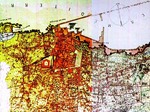
ملف:Map of Beirut port expansion plans from 1876. It wasn’t fully actualized until 1890 when the castle and the light house (on the island not Manara) were razed to make way for the new quay.jpg
لا توجد دقة أعلى متوفرة.
Map_of_Beirut_port_expansion_plans_from_1876._It_wasn’t_fully_actualized_until_1890_when_the_castle_and_the_light_house_(on_the_island_not_Manara)_were_razed_to_make_way_for_the_new_quay.jpg (638 × 474 بكسل حجم الملف: 136 كيلوبايت، نوع MIME: image/jpeg)
تاريخ الملف
اضغط على زمن/تاريخ لرؤية الملف كما بدا في هذا الزمن.
| زمن/تاريخ | صورة مصغرة | الأبعاد | مستخدم | تعليق | |
|---|---|---|---|---|---|
| حالي | 18:40، 3 فبراير 2021 | | 638 × 474 (136 كيلوبايت) | Shafei (نقاش | مساهمات) |
لا يمكنك استبدال هذا الملف.
وصلات
الصفحات التالية تحتوي على وصلة لهذه الصورة:
_were_razed_to_make_way_for_the_new_quay.jpg&oldid=2281084)