مقاطعة فلتون، كنتكي
Fulton County | |
|---|---|
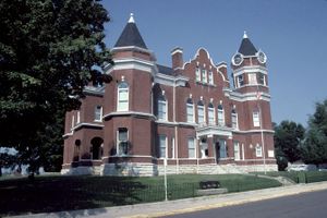
 Fulton County Courthouse in Hickman | |
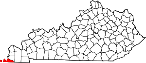
 الموقع ضمن ولاية Kentucky | |
 موقع Kentucky ضمن الولايات المتحدة | |
| الإحداثيات: 36°33′N 89°11′W / 36.55°N 89.19°W | |
| البلد | |
| State | |
| تأسست | 1845 |
| السمِيْ | Robert Fulton |
| Seat | Hickman |
| أكبر مدينة | Fulton |
| المساحة | |
| • الإجمالي | 231 ميل² (600 كم²) |
| • البر | 206 ميل² (530 كم²) |
| • الماء | 25 ميل² (60 كم²) 11%% |
| التعداد | |
| • Estimate (2018) | 6٬120 |
| • الكثافة | 33/sq mi (13/km2) |
| منطقة التوقيت | UTC−6 (Central) |
| • الصيف (التوقيت الصيفي) | UTC−5 (CDT) |
| Congressional district | 1st |
| الموقع الإلكتروني | www |
مقاطعة فلتون إنگليزية: Fulton County هي أقصى المقاطعات غرباً في ولاية كنتكي في الولايات المتحدة، و حدّها الغربي هو نهر المسيسپي.
المقاطعات المجاورة
- مقاطعة مسيسپي، مزوري (شمال غرب)
- مقاطعة هيكمان (شمال شرق)
- مقاطعة أوبايون، تنسي (جنوب)
- مقاطعة ليك، تنسي (جنوب غرب)
- مقاطعة نيو مدريد، مزوري (غرب)
الديمغرافيا
| التعداد | Pop. | ملاحظة | %± |
|---|---|---|---|
| 1850 | 4٬446 | — | |
| 1860 | 5٬317 | 19٫6% | |
| 1870 | 6٬161 | 15٫9% | |
| 1880 | 7٬977 | 29٫5% | |
| 1890 | 10٬005 | 25٫4% | |
| 1900 | 11٬546 | 15٫4% | |
| 1910 | 14٬114 | 22٫2% | |
| 1920 | 15٬197 | 7٫7% | |
| 1930 | 14٬927 | −1٫8% | |
| 1940 | 15٬413 | 3٫3% | |
| 1950 | 13٬668 | −11٫3% | |
| 1960 | 11٬256 | −17٫6% | |
| 1970 | 10٬183 | −9٫5% | |
| 1980 | 8٬971 | −11٫9% | |
| 1990 | 8٬271 | −7٫8% | |
| 2000 | 7٬752 | −6٫3% | |
| 2010 | 6٬813 | −12٫1% | |
| 2018 (تق.) | 6٬120 | [1] | −10٫2% |
| U.S. Decennial Census[2] 1790-1960[3] 1900-1990[4] 1990-2000[5] 2010-2013[6] | |||
السياسة
Presidential elections results
| Year | Republican | Democratic | Third parties |
|---|---|---|---|
| 2016 | 65.0% 1,549 | 32.5% 774 | 2.5% 59 |
| 2012 | 57.4% 1,425 | 41.2% 1,022 | 1.4% 34 |
| 2008 | 54.2% 1,530 | 43.8% 1,238 | 2.0% 57 |
| 2004 | 52.8% 1,527 | 46.4% 1,340 | 0.8% 23 |
| 2000 | 46.4% 1,293 | 52.1% 1,452 | 1.5% 43 |
| 1996 | 31.9% 863 | 59.6% 1,614 | 8.6% 233 |
| 1992 | 33.5% 1,073 | 56.6% 1,813 | 9.9% 318 |
| 1988 | 48.9% 1,474 | 50.8% 1,531 | 0.4% 11 |
| 1984 | 53.5% 1,780 | 46.1% 1,534 | 0.5% 16 |
| 1980 | 41.2% 1,462 | 56.8% 2,016 | 1.9% 69 |
| 1976 | 30.6% 1,060 | 68.3% 2,370 | 1.2% 40 |
| 1972 | 61.3% 1,807 | 34.8% 1,024 | 3.9% 116 |
| 1968 | 28.3% 1,079 | 31.5% 1,204 | 40.2% 1,535 |
| 1964 | 31.8% 1,169 | 67.9% 2,493 | 0.3% 10 |
| 1960 | 36.7% 1,567 | 63.4% 2,708 | 0.0% 0 |
| 1956 | 27.8% 1,147 | 71.5% 2,953 | 0.7% 28 |
| 1952 | 32.1% 1,266 | 67.8% 2,673 | 0.1% 3 |
| 1948 | 13.8% 450 | 76.3% 2,497 | 10.0% 326 |
| 1944 | 18.0% 654 | 81.7% 2,973 | 0.4% 13 |
| 1940 | 18.0% 791 | 81.8% 3,592 | 0.2% 9 |
| 1936 | 17.3% 782 | 82.4% 3,727 | 0.4% 17 |
| 1932 | 17.3% 837 | 82.3% 3,985 | 0.5% 23 |
| 1928 | 30.3% 1,366 | 69.6% 3,132 | 0.1% 5 |
| 1924 | 21.0% 902 | 77.5% 3,336 | 1.5% 65 |
| 1920 | 26.1% 1,365 | 73.4% 3,843 | 0.6% 31 |
| 1916 | 25.0% 747 | 73.5% 2,200 | 1.5% 45 |
| 1912 | 22.8% 520 | 70.6% 1,609 | 6.6% 150 |
التعليم
الإعلام
- WENK-AM 1240 "The Greatest Hits of All Time"
- WWKF-FM 99.3 "Today's Best Music with Ace & TJ in the Morning"
التجمعات السكنية
المدن
Census-designated place
Other unincorporated communities
انظر أيضاً
المراجع
- ^ "Population and Housing Unit Estimates". Retrieved July 29, 2019.
- ^ "U.S. Decennial Census". United States Census Bureau. Archived from the original on April 26, 2015. Retrieved August 14, 2014.
- ^ "Historical Census Browser". University of Virginia Library. Retrieved August 14, 2014.
- ^ "Population of Counties by Decennial Census: 1900 to 1990". United States Census Bureau. Retrieved August 14, 2014.
- ^ "Census 2000 PHC-T-4. Ranking Tables for Counties: 1990 and 2000" (PDF). United States Census Bureau. Retrieved August 14, 2014.
- ^ خطأ استشهاد: وسم
<ref>غير صحيح؛ لا نص تم توفيره للمراجع المسماةQF - ^ Leip, David. "Dave Leip's Atlas of U.S. Presidential Elections". uselectionatlas.org.
للاستزادة
- L. Otley Pindar, "List of the Birds of Fulton County, Kentucky," The Auk, vol. 6 (1889), pp. 310–316.
الكلمات الدالة:
?
تصنيفات:
- Pages using gadget WikiMiniAtlas
- Short description is different from Wikidata
- Coordinates on Wikidata
- مقاطعات Kentucky
- Articles containing إنگليزية-language text
- Pages using Lang-xx templates
- Pages using US Census population needing update
- مقاطعة فلتون، كنتكي
- Union City, Tennessee micropolitan area
- مقاطعات كنتكي على نهر المسيسپي
- تأسيسات 1845 في كنتكي
- أماكن مأهولة تأسست في 1845
- مقاطعات كنتكي