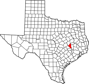
مقاطعة برازوس، تكساس
Brazos County | |
|---|---|
 الموقع ضمن ولاية Texas | |
 موقع Texas ضمن الولايات المتحدة | |
| الإحداثيات: 30°40′N 96°22′W / 30.667°N 96.367°W | |
| البلد | |
| State | |
| تأسست | 1841 |
| Seat | Bryan |
| المساحة | |
| • الإجمالي | 590 ميل² (1٬500 كم²) |
| • البر | 586 ميل² (1٬520 كم²) |
| • الماء | 5 ميل² (10 كم²) 0.76%% |
| التعداد (2000) | |
| • الإجمالي | 152٬415 |
| • الكثافة | 300/sq mi (100/km2) |
| الموقع الإلكتروني | www |
مقاطعة برازوس إنگليزية: Brazos County هي إحدى المقاطعات في ولاية تكساس، الولايات المتحدة.
السياسة
Although it is home to a prominent university, Brazos County is a Republican stronghold, with no Democratic presidential nominee having carried the county since Texas native Lyndon Johnson in his 1964 landslide. No Democrat since Hubert Humphrey in 1968 has even won more than forty percent of the county’s vote.
Presidential elections results
| Year | Republican | Democratic | Third parties |
|---|---|---|---|
| 2016 | 57.6% 38,738 | 34.4% 23,121 | 8.0% 5,352 |
| 2012 | 66.5% 37,209 | 31.2% 17,477 | 2.3% 1,276 |
| 2008 | 63.9% 37,465 | 34.9% 20,502 | 1.2% 706 |
| 2004 | 69.2% 37,594 | 29.7% 16,128 | 1.1% 587 |
| 2000 | 70.0% 32,864 | 26.3% 12,359 | 3.7% 1,718 |
| 1996 | 57.1% 22,082 | 36.2% 13,968 | 6.7% 2,594 |
| 1992 | 48.5% 23,943 | 30.0% 14,819 | 21.4% 10,578 |
| 1988 | 65.7% 29,369 | 33.3% 14,885 | 1.0% 436 |
| 1984 | 73.6% 34,733 | 26.2% 12,348 | 0.3% 140 |
| 1980 | 60.3% 17,798 | 33.4% 9,856 | 6.4% 1,885 |
| 1976 | 58.8% 15,685 | 39.8% 10,628 | 1.5% 387 |
| 1972 | 71.0% 14,243 | 28.4% 5,692 | 0.6% 116 |
| 1968 | 43.9% 6,839 | 40.4% 6,299 | 15.7% 2,441 |
| 1964 | 33.3% 4,003 | 66.5% 7,998 | 0.2% 18 |
| 1960 | 43.5% 4,553 | 56.4% 5,907 | 0.2% 17 |
| 1956 | 58.6% 4,942 | 41.1% 3,463 | 0.4% 31 |
| 1952 | 52.6% 4,681 | 47.4% 4,213 | 0.0% 2 |
| 1948 | 27.7% 1,533 | 62.6% 3,459 | 9.7% 538 |
| 1944 | 10.6% 464 | 76.8% 3,358 | 12.6% 553 |
| 1940 | 12.9% 617 | 86.9% 4,151 | 0.2% 9 |
| 1936 | 1.7% 45 | 98.2% 2,610 | 0.2% 4 |
| 1932 | 7.0% 195 | 92.4% 2,588 | 0.6% 18 |
| 1928 | 33.2% 738 | 66.6% 1,480 | 0.1% 3 |
| 1924 | 10.4% 255 | 87.1% 2,128 | 2.5% 61 |
| 1920 | 12.8% 277 | 59.0% 1,281 | 28.3% 614 |
| 1916 | 20.9% 273 | 78.5% 1,027 | 0.6% 8 |
| 1912 | 14.9% 142 | 80.0% 762 | 5.1% 49 |
التجمعات السكنية
المدن
- Bryan (county seat)
- College Station
- Navasota (partial)
- Wixon Valley
البلدات
Census-designated place
Unincorporated community
- Benchley (partly in Robertson County)
- Wellborn
بلدات أشباح
انظر أيضاً
- National Register of Historic Places listings in Brazos County, Texas
- Recorded Texas Historic Landmarks in Brazos County
الهامش
- ^ Leip, David. "Dave Leip's Atlas of U.S. Presidential Elections". uselectionatlas.org. Retrieved 2018-07-19.
وصلات خارجية
- Brazos County government
- Brazos County AgriLife Extension office
- Brazos County Attorney's Office
- Brazos County, Texas from the Handbook of Texas Online
- Brazos County from the Texas Almanac
- Brazos County from the TXGenWeb Project
- Historic Brazos County materials, hosted by the Portal to Texas History

|
Madison County | Leon County | Robertson County | 
|
| Grimes County | ||||
| Washington County | Burleson County |
الكلمات الدالة:
?
تصنيفات:
- Pages using gadget WikiMiniAtlas
- Short description is different from Wikidata
- Coordinates on Wikidata
- مقاطعات Texas
- U.S. Counties Missing Ex Image
- Pages using infobox U.S. county with unknown parameters
- Articles containing إنگليزية-language text
- Pages using Lang-xx templates
- Pages with empty portal template
- مقاطعة برازوس، تكساس
- 1843 establishments in the Republic of Texas
- Populated places established in 1843
- Bryan–College Station
- مقاطعات تكساس

